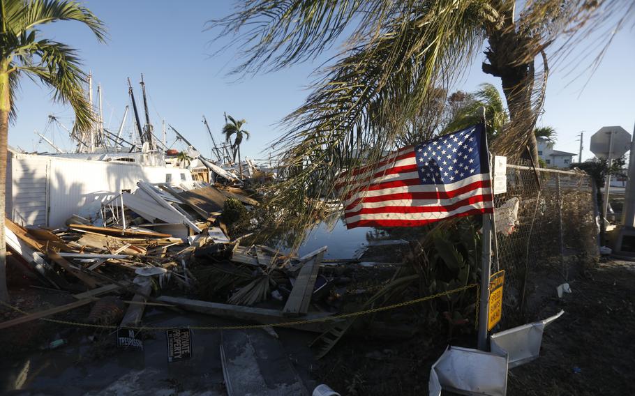
A flag flies at a mobile home park on San Carlos Island in the Fort Myers area days after Hurricane Ian hit Florida in late September 2022. (Octavio Jones/for The Washington Post)
Corry Robb's colleagues at the U.S. National Geospatial-Intelligence Agency use powerful satellites to monitor protests in Iran, missile launches in North Korea and Russian strikes on Ukraine. This fall, Robb and a team from the agency were deployed under far different circumstances: to Florida, in the aftermath of Hurricane Ian.
With climate change driving more frequent and powerful natural disasters, the intelligence agency, part of the Department of Defense, is contending with new needs closer to home. Charged with mapping and analyzing the physical world, it's turning skills sharpened in the world's danger spots toward helping people inside U.S. borders. And within days of Ian's landfall on the Florida coast, Robb and his team of analysts were processing tens of thousands of drone and satellite images per day to help direct rescuers in the Fort Myers area to their most important targets.
The week-long effort was one of the latest examples of public agencies and companies repurposing advanced technology toward improving the speed and efficacy of rescues, as more people stand in the pathway of climate-driven disasters. Now, U.S. intelligence officials are experimenting with ways to get involved, taking a small step toward an area they have often avoided: domestic deployments.
"Geospatial data is really layered data," said Robb, who helps run a team at the geospatial intelligence agency that deploys to locations around the world. "We're that foundational layer that you build everything on top of."
The deployment came after President Joe Biden declared Hurricane Ian a major disaster on Sept. 29, giving the Federal Emergency Management Agency (FEMA) the power to request help from across the federal government in response to one of the most powerful hurricanes ever to hit the United States.
The intelligence officials could accumulate drone and satellite photos of the hurricane-hit areas, plug them into their systems, and come up with a list of areas that were the likeliest to be in need of search-and-rescue teams. They could figure out which boat docks were still likely to be functional, making it easier to get around by water. They could plot quicker and safer routes for rescuers as they zipped around a torn-up and waterlogged landscape no longer navigable with Google Maps. More than 100 people died in the hurricane. Far more needed help from emergency workers.
At the peak, the analysts' system was processing about 60,000 images per day, Robb said, helping to produce rich information about the geography of the damage that made rescue efforts more effective. The agency has deployed to natural disasters for years, but it hadn't previously used drones, which meant it didn't have as rich or as many low-altitude images to work with.
The agency doesn't use classified images for emergency situations such as Hurricane Ian, since most of the people who would need access to them don't have security clearances, Robb said. But the analysts are still able to do powerful work with commercial, unclassified satellite images and pictures taken from small quadcopter drones, the kind with four spinning rotors, he said.
The data "tells us where some vulnerable communities could be," he said.
The team worked out of a parking lot in a cramped, nondescript white trailer that was small enough to be towed around by pickup truck. Sitting on black folding chairs as they stared at their computer screens, they tried to pinpoint rescue targets that people on the ground wouldn't otherwise have been able to see.
Analysts brought special large-format printers that could create detailed, waterproof maps on the spot. And they could feed data into an online portal that emergency personnel could access on their phones, helping to spread the information widely and quickly.
The effort was responsible for at least one human rescue, Robb said. After receiving a tip that a person might be stranded in a stand of mangrove trees, which can be difficult to search because of their thick root structures, an analyst pored over drone imagery and found a possible target for a rescue team. The analyst was right.
The emergency responders "were getting the information that they needed to be able to turn the power back on. Find the people still trapped in debris. All that kind of stuff," Robb said.
Analysts such as Robb aren't the only national security personnel finding themselves pulled more into a different kind of fight, one that is driven by climate change rather than human enemies. Across the globe, armed forces are also increasingly being seen as the emergency responders of last resort, as wildfires, floods and other disasters start to strain the civilian safety net.
The result can be complicated: officials who are accustomed to fighting foreign adversaries sometimes say that natural disasters are an unwanted distraction. And in societies in which attitudes toward the military are mixed or in which armies have occasionally subverted civilian leaders, widespread domestic deployments can cause tension.
That's true in the United States as well, where intelligence agencies restrain their activities domestically.
That's why the team deployed under the control of FEMA, a civilian nonmilitary agency, he said.
"There are some very strong sensitivities and some hot-button issues," Robb said. But, he said, "we're helping fellow Americans, which is kind of neat."