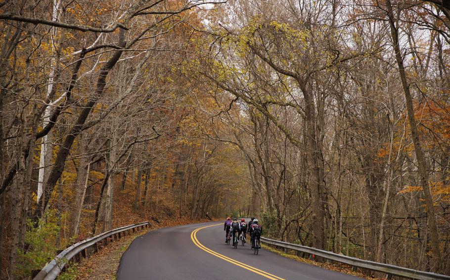
Cyclists on Old State Road 37 in Bloomington, Ind., on Nov. 13, 2021. (James Brosher/The Washington Post)
Sitting outside a century-old confectionery in southern Indiana, Jim Schroeder popped a piece of candy into his mouth and laid out my future. After cycling along country roads that could moonlight as an airport runway, we would climb a succession of hills before coasting into Bloomington, the halfway point of our 122.5-mile bike ride.
“You will want to use your granny gear,” the avid cyclist and Bloomington-based bike guide suggested, referring to the high gear used on steep ascents more often associated with Colorado than the Hoosier State.
Assuming the Midwestern hills would be speed bumps by another name, I ignored his advice. My stubbornness would later come back to taunt me: I had to hop off my bike not once but three times for the push of shame.
“If you’d used your granny gear …” became his common refrain.
Indiana’s vertical terrain is a key feature of the route that Jim spent six years designing and rallying behind. “USBR 235 is for people who want to see more than soybean and cornfields and flat, flat, flat,” he said. The hills of southern Indiana might have remained a state secret if not for the U.S. Bicycle Route System (USBRS), a network of bike-friendly routes with transnational aspirations. In August, the Adventure Cycling Association announced the latest crop of initiates: 18 itineraries in five states, including Jim’s alternate from Indianapolis to Seymour. The new additions enlarge the web by 2,903 miles, to 17,734 miles in 31 states and the District.
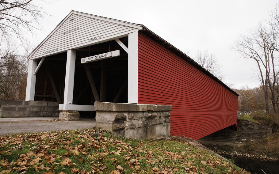
The Ramp Creek Covered Bridge stands at the northern entrance to the nearly 16,000-acre Brown County State Park near Nashville, Ind. (James Brosher/The Washington Post)
“The national corridor plan is to have 50,000 miles of routes across the United States that will be suitable for long-distance bike travel in a mix of environments,” said Jennifer Hamelman, USBRS program manager with the Adventure Cycling Association, a partner in the project. “It will be like the interstate highway system,” but for human-powered two-wheelers.
The idea of constructing an Interstate 80 for cyclists first surfaced in the late 1960s. The seed grew into a sapling a decade later, when the American Association of State Highway and Transportation Officials, a nonprofit organization that represents state highway and transportation departments, threw its support behind the concept. In 1982, it debuted the first two routes: USBR 1 in Virginia and North Carolina and USBR 76 in Virginia, Kentucky and Illinois. Enthusiasm for the project ebbed in the following years but resurged in the early aughts, around the same time the Adventure Cycling Association joined the mission. Since 2011, the associations have been unveiling new routes twice a year. The August collection, which also included realignments in Florida and California, set a record for the highest number of designations and total mileage since the program’s inception.
“The last cycle was the most successful in terms of hard numbers,” Hamelman said, adding that the association will announce the next round of routes in December.
The USBRS is not constructing new infrastructure; it knits together preexisting tracks, such as urban bike lanes, park pathways, rails-to-trails conversions, rural roads and highway shoulders. The patchwork of roads mirrors the country’s kaleidoscope of landscapes. The scenery can change as dramatically as the conditions under your wheels - from city to country, farmland to forest, coastline to desert.
Only a quarter of the USBRS has signage, so bikers follow local or state markers wherever they are available. You can download the maps through the Adventure Cycling Association’s website or find them on Ride With GPS. Navigation can be challenging if you are solo and unfamiliar with the area, which is why I recruited Jim to play tour guide. In addition to his job as a pharmacist, he runs a bike-touring company called Indiana Jim’s Bicycling Adventures. He mapped out our three-day itinerary, suggesting overnight accommodations and incorporating detours to the museum at Bill Monroe’s Music Park & Campground in Bean Blossom (the “Father of Bluegrass Music” owned the park from the early 1950s until his death in 1996) and the eccentric Story Inn on the edge of Brown County State Park. He also arranged a shuttle to transport my bags between hotels and kindly loaned me his wife’s road bike.
For USBR 235, an alternative to USBR 35, we kicked off the ride with a ceremonial spin around Monument Circle in downtown Indianapolis. From there, we moved seamlessly from the Indianapolis Cultural Trail to White River State Park, sticking to bike lanes. On the outskirts of the city, we shared the road with (mostly polite) cars as we rolled past the Eli Lilly campus, power plants and an industrial area that Jim admitted “is ugly, but it’s real America.” The road turned more rural and hushed. Papery cornstalks rustled in the wind. A deer darted through the woods. A hawk flew figure-eights overhead. We stopped in Martinsville, which bills itself as the “City of Mineral Water,” for a sugar fix at the Martinsville Candy Kitchen.
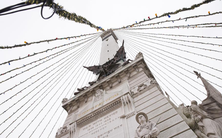
The Soldiers and Sailors Monument stands over Monument Circle in downtown Indianapolis. (James Brosher/The Washington Post)
The hills came, and I conquered. I could not make the same claim on the following days. At the end of the 30-mile ride to Brown County State Park, I hoofed it up a steep incline leading to the Abe Martin Lodge, my bed for the night. During our 40-miler to Seymour, I lost momentum twice. Fortunately, the hills on the final stretch receded into wavelets, then flattened out like a glassy pond. As Jim and I pedaled toward the finish line, we compared our favorite songs by John Mellencamp, who was born in Seymour and owns an estate in the Bloomington area. I debated which song to use as my USBR 235 anthem: “Pink Houses” or “Hurts So Good.”
The Story Inn in Story, Ind., is on the edge of Brown County State Park. (James Brosher/The Washington Post)
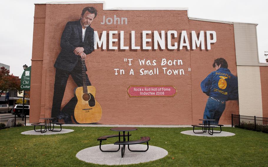
A mural dedicated to musician John Mellencamp adorns the side of a music store in Seymour, Ind. Mellencamp was born in Seymour and owns an estate in the Bloomington area. (James Brosher/The Washington Post)
At a diner in town, Jim bought me a celebratory cup of coffee and handed me printouts of the route, a certificate of achievement of sorts. Of course, my journey didn’t have to end in Seymour. I could bid Jim farewell and jump onto USBR 35 and pedal south to Kentucky or north to Michigan. But instead, I caught a ride back to Indianapolis and pressed the reset button on my bike odometer.
Where to cycle next? Any of the new routes, obviously. Below are descriptions of the trails, plus the total mileage for each state. Ohio, which added almost 1,200 miles, boasts the highest count. (Note: Mileage can vary in each direction because of road features and restrictions, such as one-way streets and roundabouts.) The network is just going to expand, so there’s no time better than now to start spinning through the USBR miles - with or without your granny gear.
OHIO
Number of additions: Six
Total USBR miles: 1,531
The routes: The 374.1-mile USBR 21 runs like a crooked zipper down the Buckeye State. The route starts in Cleveland’s Edgewater Park and follows the Ohio to Erie Trail through big cities (Akron, Cleveland), quaint villages (Millersburg, South Charleston) and farming communities knee-deep in corn and soy. In Cincinnati, bikers go with the flow of the Ohio River until Aberdeen, where they can wave a padded-gloved hand at Kentucky, across the river. The 196.1-mile USBR 44 picks up where 21 leaves off in Massillon and pushes westward until it bumps into Fort Wayne, Ind.
The 308.2-mile USBR 25 connects Toledo with Cincinnati and hitches a ride along the Great Miami River Trail, which Ohio Magazine called the “Best Bike Trail in Ohio” in 2019. From Cincinnati, the trail overlaps with USBR 21. For views from the opposite bank of the Great Miami River, jump on USBR 225, the 2.3-mile alternate route that passes through Piqua, where - “tra-la-la” - the kids’ book series “Captain Underpants” is set.
The Firelands Rails to Trails, a volunteer organization that manages the North Coast Inland Trail in Huron County, refers to the 225.6-mile USBR 30 as the original “east-west transcontinental route.” Cyclists trace the bottom lip of Lake Erie, which stretches from the Pennsylvania border to about 10 miles north of Toledo, near the Michigan state line. Between the towns of Elyria and Genoa, riders pedal along the North Coast Inland Trail, a rails-to-trails project that plans to link Ohio with its eastern and western neighbors. To ride tandem with Lake Erie, take the 78.1-mile USBR 230 alternate, which runs west of Cleveland and through Sandusky, home of Cedar Point, the roller coaster capital of the world, before veering slightly inland.
UTAH
Number of additions: Five
Total USBR miles: 1,167 miles
The routes: The 349.8-mile USBR 77 pushes off from the Idaho border and travels south to the Cache Valley, which is named after the early trappers who hid (“cacher” in French) their pelts and provisions here. From Logan, a university town on the Logan River, cyclists roll through the Wasatch Front and the eeny, meeny, miny, moe towns of Ogden, Salt Lake City and Provo. The route climbs to an elevation of more than 8,300 feet into Fishlake National Forest, where aspens form a halo around the state’s largest natural mountain lake. The journey ends in Torrey, the gateway to the Capitol Reef National Park, and joins USBR 70 from Cedar City to the Colorado border. The 40.6-mile USBR 677 takes a more panoramic route along Utah Lake, a freshwater lake shaped like a butterfly wing. The 88.8-mile USBR 877 bridges two other routes: USBR 77 in Sigurd, a tiny town with Danish roots, and 79 in Panguitch, northwest of Bryce Canyon National Park. The 9.4-mile USBR 679 provides the missing link between USBR 70 at Duck Creek Village, a jumping-off point for those going to national parks, and USBR 79, at Highway 89. The 269.3-mile USBR 79 existed before this latest round of additions, but it stopped short of the Arizona state line. Now, bikers can ride the final miles from Kanab, an outdoor adventure hub and film site known as “Little Hollywood,” to the southern exit of Utah.
WASHINGTON STATE
Number of additions: Four
Total USBR miles: 892
The routes: The 103.4-mile USBR 81 wriggles through the undulating wheat, barley and lentil fields of the Palouse, a bountiful agricultural area in the Pacific Northwest. The route passes through farming communities such as Pullman, home of Washington State University, then plunges about 2,000 feet through Wawawai Canyon to the Snake River. Along the country’s ninth-longest river, bikers will pick up the scent of Lewis and Clark en route to Clarkston, Wash. (Across the river is the other half of the Pacific Northwest duo: Lewiston, Idaho.) The ride ends in Asotin, the head of Snake River Road and Washington’s only access point to Hells Canyon, North America’s deepest river gorge. The alternate 23.1-mile USBR 281 surfs the waves of pastoral hills surrounding the prairie towns of Colton and Uniontown. The route terminates on a bluff that looms over the confluence of the Clearwater and Snake rivers, on the Idaho state line.
USBR 40 has big ambitions (the trail will eventually span 400 miles across the state), but you have to start somewhere - say, 1.9 miles from the Idaho border to Tekoa, a small town curled at the feet of Tekoa Mountain.
On the 77.9-mile USBR 20, bikers set off near Lewis & Clark State Park and cross a slice of the ancient basalt flow known as the Columbia Plateau. The route features two 2,000-feet-and-change crests: one near Dayton and the Tucannon River basin, and the other along the Pataha Valley to the Alpowa Summit. Afterward, riders glide down to the Snake River and through Chief Timothy State Park, a 282-acre island on Lower Granite Lake. The route ends at Clarkston’s Southway Bridge, a drier route over the Snake River to Idaho.
CALIFORNIA
Number of additions: Two
Total USBR miles: 1,003
The routes: The 333.6-mile USBR 66 rides shotgun on Route 66, following as much of the Mother Road as is logistically possible. The route travels from beachy (Santa Monica Pier) to bone dry (the Mojave Desert town of Needles). Bikers will laugh in the face of Los Angeles traffic as they zip through Beverly Hills, Hollywood and Chinatown. Below the San Gabriel Mountains, the Pacific Electric Trail covers a 20-mile stretch of converted railroad tracks that once transported citrus, wine and, during World War II, supplies and troops. The route jags north to the Route 66-rich cities of Victorville and Barstow and calls it a wrap at the Colorado River, near the Arizona border.
The 440.4-mile USBR 95 takes riders on a majestic and anthemic journey from Crescent City, where the ocean, ancient redwoods and two wild rivers collide near the Oregon border, down the Pacific Coast to San Francisco. Cyclists will feel as if they are pedaling inside a View-Master as redwood forests, sculptural rock formations and cliffside lighthouses flicker by. Bikers will also check off several national and state parks, two forts (Baker and Bragg) and a number of cities still practicing the Endless Summer of Love, such as Eureka and Arcata. From Sausalito, the ride crescendos on the Golden Gate Bridge, with a final thrill ride through one of the country’s hilliest cities.
PLEASE NOTE: Potential travelers should take local and national public health directives regarding the pandemic into consideration before planning any trips. Travel health notice information can be found on the Centers for Disease Control and Prevention’s interactive map showing travel recommendations by destination and the CDC’s travel health notice webpage.