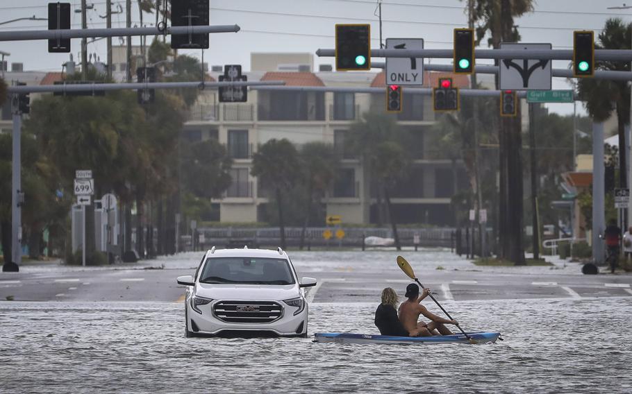
A man and woman kayak past an abandoned vehicle in the intersection of Boca Ciega Drive and Pasadena Avenue in St. Pete Beach, Florida. (Chris Urso/TNS)
MIAMI — Hurricane Idalia made landfall in Florida’s Big Bend early Wednesday morning as a Category 3 hurricane, pushing a wall of destructive water into coastal communities, shutting down part of a major interstate and knocking out power to hundreds of thousands of people.
By early afternoon, the fast-moving storm, now a Category 1, was already well into Georgia. Rescue efforts — and damage assessments — began immediately in the sparsely populated Nature Coast, which was hammered with 125 mph sustained winds in the strike zone at Keaton Beach.
Given Idalia’s power, the early assessments were encouraging. Gov. Ron DeSantis said Wednesday that there were no confirmed deaths yet and power restoration efforts were underway across the state, which reported no “major damage” from Idalia thus far.
“The eye of Hurricane Idalia has left the state of Florida,” he said. “We’re still assessing what is all going on on the ground in the places that had the initial impact.”
Deanne Criswell, director of the Federal Emergency Management Agency, told reporters Wednesday that it was too soon to assess how much recovery efforts would cost.
“It will take several days to get a full understanding of what the initial assessment, the damage assessment is,” she said. “But it will take longer to get a full picture of the total amount of impact of this.”
There were widespread reports of flooding from the heavily populated waterfronts around Tampa Bay north to Cedar Key, another isolated Big Bend enclave. Storm surge, Idalia’s biggest threat, reached 6.8 feet in Cedar Key early Wednesday, filling streets and flooding some homes and buildings. That broke a record for the small city, although it didn’t appear to reach the 16-foot maximum forecast by the National Hurricane Center.
Livestreams of webcams stationed throughout the area showed roofs ripped off sheds near Horseshoe Beach, buildings completely inundated at Steinhatchee Marina and roads underwater in Cedar Key. Spots across the Big Bend region were reporting 2 to 6 inches of rain as Idalia moved inland, according to the WeatherSTEM network, with a peak of 8.5 inches so far east of Tallahassee, near the Georgia border.
The worst of the wind damage appeared to be in the city of Perry, in Taylor County. High winds tore roofs off of buildings, metal awnings off of gas stations and blew in the glass windows of storefronts in the town of fewer than 7,000 people.
More than 280,000 households in Florida were without power Wednesday morning, according to poweroutage.us, with a concentration in Suwanee County, where nearly every customer lacked power.
The Associated Press reported that part of I-75, the major highway connecting Florida and Georgia, was closed in Georgia due to downed power lines. Dozens of bridges and roads, from the Big Bend area down to Sarasota, remained closed or inaccessible as officials checked them for damage. The bridge crossing Steinhatchee, in Taylor County, was cracked, and photos show the ocean chewed off chunks of at least one road, on Sarasota County’s barrier island.
In the state capital of Tallahassee, downed trees blocked roads, and one, a 100-year-old oak tree, fell near the Governor’s mansion. Casey DeSantis, Florida’s first lady, said she and her children were home and “no one was injured.”
In an afternoon press conference, Kevin Guthrie, head of Florida’s Division of Emergency Management, said that the search and rescue effort had already begun, but warned that it would take longer than it did last year after Hurricane Ian. Idalia came ashore in a lightly populated area, where small communities are spaced out between huge stretches of forest or nature preserves, as opposed to the densely packed neighborhoods in Southwest Florida.
“Some of this is going to take longer than what we experienced with initial search and rescue efforts in Fort Myers, just because of the landscape,” Guthrie said.
He said there were also very few people who didn’t evacuate. According to the state’s count, there were around 100 people who didn’t evacuate in Levy County and about 50 in Taylor County.
The good news, Guthrie said, is that state and local agencies were almost fully caught up on all calls for help from the region. He said a couple of 911 centers went down “briefly, for about 20 to 30 minutes” during the storm, and they’re nearly done with the “minor” backlog of calls for help.
“There is no one in distress that has not been taken care of. We have a lot of people that have called 911 saying ‘I’m entrapped in my house. I’m OK, but I need help,” Guthrie said. “We’re going to get to those folks just as fast as we can get our emergency access teams in to them.”
A Cat 3 at landfall
In the hours before landfall, Idalia’s maximum sustained winds hit 130 mph, Category 4 strength, but slightly weakened back to 125 mph and Category 3 — not a significant difference as far as potential damage. The hurricane had also spawned tornado watches and warnings across much of north Central Florida and as far as south Georgia as Idalia’s outer bands raked both states.
It made landfall in Keaton Beach around 7:45 a.m. and quickly trekked north, at 20 mph. The fast pace kept the biting winds from lingering too long on any of the already-thrashed communities in its path and kept rain from piling up too much.
By 1 p.m., the hurricane center said Idalia had weakened to a Category 1, with sustained winds near 80 mph, as it crossed over Southern Georgia. It was moving north-northeast at a fast clip — 20 mph. It was about 40 miles northeast of Valdosta, Georgia.
Overnight, the fast-moving storm jogged a bit to the northeast in a long-expected turn that spared the state capital of Tallahassee from the strongest winds around Idalia’s relatively small eyewall. But the full fury of the storm slammed the Big Bend, which saw up to 7 feet of surge in the fishing town of Cedar Key, where a NOAA tidal gauge was installed.
Wednesday morning, Cedar Key’s fire rescue team warned people to stay off of the island due to downed trees and propane tanks “blowing off” buildings. “We have multiple trees down, debris in the roads, do not come,” they posted on Facebook.
Miami Herald staff writer Joey Flechas and Mclatchy White House correspondent Alex Roarty contributed to this report.
©2023 Miami Herald. Visit at miamiherald.com. Distributed by Tribune Content Agency, LLC.