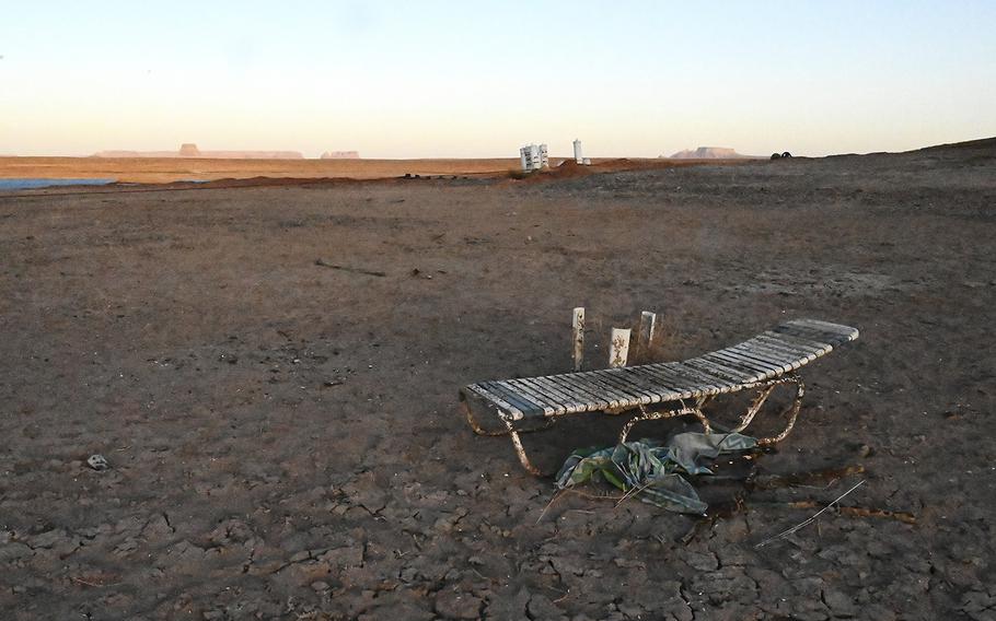
In an area near Wahweap Marina that was previously underwater at Lake Powell, the earth is dry and cracked on April 5, 2022, in Page, Arizona. (RJ Sangosti/The Denver Post/TNS)
PAGE, Ariz. (Tribune News Service) — White sandstone cliffs create a ring around Lake Powell in contrast to the honey- and red-colored desert rock nearby. Evidence that water once, not all that long ago, filled America's second-largest reservoir.
Fed by the Colorado River, Lake Powell, in south-central Utah, has seen wet years and dry years over the past two decades. Mostly dry years.
Buoys no longer bob, they tilt, sitting on dry sand. Beer cans, punctured pontoons and deck chairs litter miles of waterless lake bed.
The last time entire sections of Lake Powell were this dry, the place was actually called Glen Canyon. That was before the completion of the Glen Canyon Dam in 1963, which flooded the canyon and created the reservoir.
The reservoir's water is receding because the Colorado River is drying. Climatologists aren't sure when, or if, Powell will ever fill again. Rather, they expect conditions to worsen.
The chalky ring around Powell is just one sign of many that the 40 million people who directly depend on the Colorado River must fundamentally change their way of life, experts agree. And it's going to hurt, experts say.
"This is not a drought, this is aridification," Rhett Larson, a water law professor at Arizona State University, said. "This is not something we can wait out. This is not something we can survive. This is the new world we live in."
That likely means less water for major cities like Denver, Las Vegas, Los Angeles, Phoenix and San Diego. Higher electricity and grocery bills, too. Less swimming in reservoirs like Powell. Less boating, white water rafting, swimming. Fewer tourists.
The seven states relying on water from the Colorado River Basin are drawing too much. Hydrologists warned this would happen generations ago, though politicians and government officials failed to listen or decided not to.
"They knew this was a problem and they elected to kick the can down the road," Brad Udall, water and climate scientist at Colorado State University, said. "They knew better and they did it anyway."
Those seven states — Arizona, California, Colorado, Nevada, New Mexico, Utah and Wyoming — tapped into the river and unlocked the American West. But their agreement, the 1922 Colorado River Compact, eventually also steered the region toward disaster.
The framers of that compact overestimated the amount of water available, most experts agree. They imposed rigid standards and deadlines on one of the world's wildest rivers. And they excluded dozens of Native American tribes from negotiating for their fair share.
Within just a few generations, the West's thirst for water outpaced its supply. Then came the historic — and ongoing — drought that started in 2000, made even worse by a drying climate.
Cities, counties and states cut their water use multiple times in the last 20 years. But they'll have to cut deeper and learn a new way to split the river, Andy Mueller, general manager of the Colorado River District, said. And soon.
"There is no other answer," Mueller said.
On its face, the 1922 Colorado River Compact is fairly simple. It measures water in acre-feet — a volume equal to a year's worth for two families of four — and splits the river in half.
Upper-basin states, Colorado, New Mexico, Utah and Wyoming, receive a total of 7.5 million acre-feet from the river. So do the lower-basin states of Arizona, California and Nevada.
Some fine print and future negotiations gave the lower basin another million acre-feet (totaling 8.5 million) and set aside 1.5 million acre-feet for Mexico, the river's last stop before pouring into the Sea of Cortez.
During the negotiations, representatives from each state and the federal government assumed the river would flow with an average of up to 18 million acre-feet, Jennifer Gimbel, interim director of CSU's Water Center, said.
They agreed to return in 40 years and split up whatever water remained in the river.
But that time would never come.
A few people saw the signs and wrote about them. Like Eugene Clyde LaRue, a federal hydrologist who raised red flags in 1916, again in 1920 and then again in 1925. Or his colleague at the U.S. Geological Survey, Herman Stabler, that same decade.
William L. Sibert, chairman of the Colorado River Board, understood that flow estimates used in the 1922 compact were based on exceptionally wet years, not average or typical flows. Major droughts lurked in the not-so-distant past and would inevitably return, he wrote to the Secretary of the Interior in 1928.
Rather than 18 million acre-feet, the river probably flowed between 10 million and 14.5 million acre-feet a year, Sibert figured.
Were these early warnings ignored?
Or did the men negotiating the compact make an honest mistake with the limited data they had?
Did their desire to tame and develop the American West cloud their judgment?
Or did the inflated numbers ease negotiations that were already tense?
Whatever the reason, the errors set out in the compact weren't immediately apparent. The West hadn't yet grown as thirsty as it is today.
But development would catch up and eventually the states would see that they set concrete standards for a river that fluctuates between feast and famine. They should have instead divided percentages of whatever flows that were actually available, Mark Squillace, a water law professor at the University of Colorado, said.
Now Mueller wonders when water levels will shrink so low that the states will no longer be able to meet their compact requirement.
The compact negotiators also failed — or refused — to include the approximately 30 Native American tribes dependent on the river. Now acknowledged by the states and federal government, those tribes hold the rights to enough water to scuttle whatever balance remains, Squillace said.
Despite the claims of federal officials, many tribes still feel excluded from negotiations concerning the river's future, Manuel Heart, chairman of the Ute Mountain Ute Tribe, said.
Regardless of those now-obvious errors and omissions, with the compact, the West exploded with growth. The agreement gave life to massive cities, picturesque towns, factories, farms and ranches.
By the 1960s, Arizona and California's populations had more than quadrupled. New Mexico and Nevada's tripled. Colorado and Utah's doubled. Wyoming's population grew by nearly 70%.
People kept coming. So did the warnings.
In 1965 the Colorado Water Conservation Board hired civil engineer Royce J. Tipton to examine a massive canal proposal that would drain more Colorado River water for still-fledgling cities like Phoenix and Tucson. He reported back to Congress that the Central Arizona Project would be an "extremely unwise" undertaking. Barring a massive pipeline from somewhere else, the states in the Colorado River Basin wouldn't have enough water to meet their compact requirements in the decades to come.
"Whatever method of analysis of the water supplies of the Colorado River is used, the results are essentially the same… there is not enough water in the river," Tipton wrote.
If the project came to pass, water shortages could hit the basin by the year 2000, Tipton warned.
Congress still approved the project in 1968 and Colorado River water began to flow into south and central Arizona by the 1980s.
"We thought we could engineer nature," Mueller said. "Huge mistake."
As Arizona began to take more and more out of the Colorado River, so too did California.
By the mid-1990s California was taking much more water than it was allowed, so much so that then-Secretary of the Interior Bruce Babbitt threatened the state with the cudgel of a federal government takeover if it didn't get its water use in check.
All the while, the upper-basin states used less water than they were allotted, Mueller said.
Plus if the Colorado River ran short, the massive reservoirs Lake Mead and its younger sibling upriver, Lake Powell sat ready. They served as the checking and savings accounts for the Colorado River, steadying flows and humming as they generated renewable and affordable electricity.
And those reservoirs had been filled to the brim as recently as 1983 and were nearly full again in 1999. Right before the crash.
The lines of supply and demand crossed in the year 2000.
The West's need for Colorado River water surpassed the river's supply, according to a now-infamous report from the U.S. Bureau of Reclamation, published in 2013.
And then the drought. Less snow and rain. Higher temperatures. Less water to feed the river. Less moisture to beat back the wildfires.
The drought that began at the turn of the century is still going. It's now called a megadrought. And it's expected not only to continue but to turn worse.
Climate change is speeding up the damage, making it permanent, Udall said.
The snow that feeds the Colorado River doesn't fall as heavily as it once did. What does fall melts too fast to make it downstream before it's soaked up by the parched soils and plants. More water still is absorbed into the hotter and drier atmosphere.
For every degree of average temperatures rise, rivers and stream flows decline between 3% and 9%, Mueller testified before a Congressional committee in June. And average temperatures in most countries have risen more than four degrees since 1895 with a faster rise in the last decade.
For example, Mueller cited 2021 snowpack statistics and noted that while Colorado's mountains saw about 89% of their normal amount of snow, which he called "pretty good," less than 37% of the normal runoff water made it down to Lake Powell.
"The change in heat is just killing this river," he said.
Udall studied the Colorado River's flows and said they dropped by 20% between 1906 and 1999.
The government started catching on perhaps five years into the drought, Gimbel said. It rode out the first few years.
"It was a tumbling of circumstances and toward the end of 2005 it was clear this was getting to be a serious matter," Gimbel said.
And it's "been really bad since 2018," Udall said. Maybe 40% lower.
Cities and states launched conservation programs, some offered money to residents willing to replace their water-dependent lawns. Farmers planted new, less-thirsty crops, invested in new and more-efficient water technologies or even let their fields lay fallow. The seven states reconvened.
In 2007 the states set limits to how low they'd allow Lake Mead's water elevation to drop before cutting supply to Arizona and Nevada. California's share wouldn't change.
Lake Mead dropped below one limit briefly in 2015 and then again the next year. It sunk to a record low in May.
The states agreed to more cuts in 2019, including steps to cut California's supply this time. Then they cut even more in 2021.
None of the agreements have yet triggered cuts for California, though, according to Tina Shields, water department manager for the state's massive Imperial Irrigation District.
And the lower basin states consistently draw more water than they're allotted, according to Amy Ostdiek, section chief of interstate, federal and water information for the Colorado Water Conservation Board. They used 117% of their allotment last year and more than 113% the year before.
The basin's slow leak continues. Water levels at the reservoirs are still dropping. The Colorado River Basin's savings are running out.
Federal officials declared the first-ever water shortage at Lake Mead in 2021 and Lake Powell began to flirt with water levels so low that engineers fear it might no longer be able to produce electricity.
If reservoirs drop even lower — to a point called "deadpool" — officials at the dams will no longer be able to send water downstream at all, Bureau of Reclamation Commissioner Camille Touton said. Although that appears unlikely at this point.
Reclamation officials stepped in last year, ordering upstream dams to spill their water in an emergency plan to add at least a little water to Powell and Mead. More releases are a possibility, Touton said.
But upstream reservoirs don't have much more water to give, Mueller said.
"The three reservoirs that sit above Powell sit at about 23%, 27% and somewhere around 50% full, respectively," Mueller testified before a Congressional committee in June. "They are stark and empty."
Despite the downward trend, government officials across the West continue proposing projects that would take even more water out of the Colorado River. The Lake Powell Pipeline in southwest Utah, an expansion of Denver Water's Gross Reservoir in Boulder County and the Chimney Hollow Reservoir west of Loveland, to name a few.
"I'm stunned that people haven't risen up and said, 'Why are you doing this?'" Squillace said. "We cannot continue to do business as usual. It's not working. It's getting worse. And unfortunately we still have our heads in the sand."
Cities in California sank as much as a foot as people pumped more from groundwater reserves, the San Francisco Chronicle reported. Forests burned through by wildfires are likely now to be replaced by grassy savannahs, the Arizona Republic reported.
Colorado is expected to lose half its snow by 2080 and — alongside Utah and Wyoming — shift toward an ecosystem more closely resembling Arizona.
And the United States lost ground on its battle against climate change during former President Donald Trump's administration, the New York Times reported.
Lake Powell has a 25% annual chance over each of the next four years of dropping below the point where the Glen Canyon Dam can generate electricity, Nick Williams, power manager with the Bureau of Reclamation, said.
Electric bills for some customers — especially poor, rural and indigenous — within the Western Area Power Administration's coverage area have already increased as much as 14%, according to Lisa Meiman, a spokeswoman for the administration, which distributes electricity generated at Mead and Powell.
And further increases are likely, if not inevitable, Meiman said. It all depends on how diversified utilities that use WAPA's electricity are.
"This is an extremely challenging situation," Meiman said. "There aren't simple solutions. There aren't easy solutions. We've exhausted all of those."
Grocery bills have already increased as farmers face tighter water budgets, Shields said. And they'll climb higher if additional cuts plague the industry.
Agriculture consumes the vast majority of Colorado River water across the basin, so policy makers see the industry as an obvious target for conservation efforts.
Shields alluded to a hypothetical $14 head of lettuce and said that whatever cuts farmers face will ultimately result in more expensive or harder-to-find fruits and vegetables. Plus the Imperial Valley grows large quantities of alfalfa, which is used to feed livestock. So not only could meat become more expensive but so could dairy products like milk, cheese and ice cream.
"You don't just turn things on and off in the agriculture world," Shields said. "You have to cultivate the crop, you have to cultivate the land."
A cut in the Imperial Valley's water supply could lead to the "holy war of litigation," Shields said. She pointed to the West's growing cities as a focal point for conservation efforts.
The Ute Mountain Utes, in southwest Colorado and the Four Corners region, can't afford any more cuts either, Chairman Manuel Heart said. They're already eking by with just 10% of the water supply to which they have the rights. With that they can only irrigate a small percentage of the 7,700 acres they normally cultivate with alfalfa to sell and corn for tribal members to eat.
"We don't have very much time," Heart said. "Our snowpack is getting worse every year."
Wherever the cuts come from, the economic implications expand far out of the Colorado River Basin.
And then there's the damage to the natural environment. With less water to go around, plants and wild animals suffer. But also pollutants that factories and other industries pour into waterways will turn up in higher concentrations, Mueller said. There isn't enough water to dilute that pollution.
The bottom line, Mueller said, is that one way or the other the American West must use less water.
And the Colorado River Basin states must find a new way forward soon because the cuts they've made since 2007 expire in less than four years, Mueller said. Without a new plan in hand by the start of 2026, they risk ceding control to the federal government.
That route, legal experts agree, could easily lead to lawsuits between states, which would waste not only money but also time. Time the West doesn't have.
"Trying to resolve the issue in court would just be a quagmire and probably a mistake," Squillace said.
While the states negotiate, the federal government can send money, Touton said. Billions unlocked with President Joe Biden's Bipartisan Infrastructure Bill effectively doubled Reclamation's budget over the next five years. The agency can use that money to help build new water storage or delivery projects, fund new technologies — like more efficient farming equipment or projects to desalinate previously unusable water — or to pay farmers not to plant.
But while those negotiations are underway the Native American tribes must also be included, Heart said. Each tribe is a sovereign nation with its own goals, aspirations and its own water rights.
To this point, Heart said the tribes haven't been fully included in ongoing negotiations and he asked for new legislation at the state and federal levels to codify their seat at the table. He also said the Ute Mountain Utes could use federal money for water projects too.
All told, the 30 tribes depending on the Colorado River hold the rights to more than a quarter of the river's annual flows, Heart said.
Many of those rights are as old as they come too, Squillace said, which means they take priority over younger — or junior — water right holders.
So far the tribes haven't developed uses for most of their water so their rights haven't posed much of an issue, Mueller said. But if they ever decide to use all the water to which they're entitled, it could spell doom for many others along the Colorado River.
What's next?
Before even thinking about the next century, experts agree the West must make short-term water cuts just to survive until 2026.
And the lower-basin states like Arizona and California should lead the charge, Colorado Attorney General Phil Weiser told The Denver Post.
"It's no longer an option for the lower-basin states to use more (water) than we have," Weiser said.
But as weather patterns continue to change, less water will likely be available for the upper-basin states to use as well, Becky Mitchell, director of the Colorado Water Conservation Board, said.
So realistically each of the seven states in the Colorado River Basin, and the people in them, must get used to having less water, Mueller said.
People a century ago assumed the river would provide up to 18 million acre-feet a year, but it could soon hold as little as half of that, Larson said.
Conversations about possible solutions are already underway, Mueller said. A fresh round of cuts could be announced within the next 10 months.
The states can't ditch the original compact entirely, Squillace said. Starting from scratch would require approval from seven state legislatures and then Congress. Impractical, if not impossible, in today's political climate.
Better instead to tweak the existing document with better data, more flexible standards and with all parties at the table.
Otherwise, Mueller said, we risk repeating the same mistakes we made a century ago.
———
©2022 MediaNews Group, Inc.
Visit at denverpost.com.
Distributed by Tribune Content Agency, LLC.