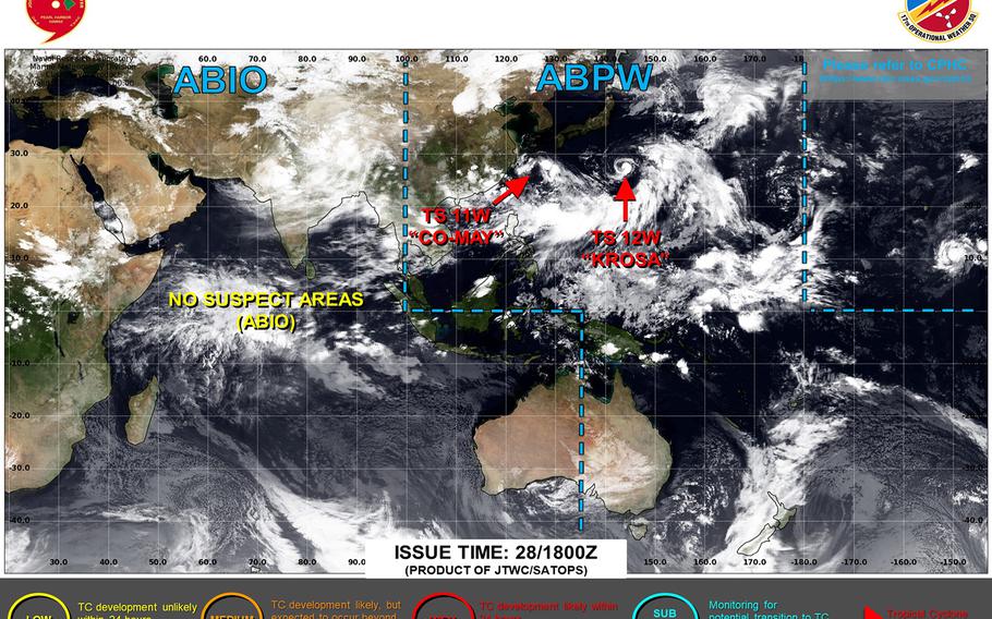
Subscribe
Tropical Depression 10W spawns southeast of Okinawa Tuesday afternoon; 98W Invest labeled medium area for development.

Tropical Depression 10W spawns southeast of Okinawa Tuesday afternoon; 98W Invest labeled medium area for development. (Joint Typhoon Warning Center)

7:10 p.m. Tuesday, July 22, Japan time: First warning has been issued on Tropical Depression 10W by Joint Typhoon Warning Center. It’s not forecast to become a typhoon at the moment, and is due to pass about 90 miles southwest of Kadena Air Base, Okinawa, at mid-evening Thursday as a tropical storm.

At 3 p.m., 10W was about 665 miles south-southeast of Kadena, moving north-northwest at 11 mph with 30-mph sustained winds and 40-mph gusts. U.S. bases on Okinawa remained in seasonal Tropical Cyclone Condition of Readiness 4 through Tuesday afternoon.

JTWC projects 10W to keep moving generally northwest over the next couple of days, peaking at 52-mph sustained winds and 63-mph gusts at center as it hurtles 92 miles southwest of Kadena at around 9 p.m. Thursday.

Kadena’s extended forecast calls for 23-mph sustained winds and 40-mph gusts as 10W makes its way northwest past the base Thursday, with scattered showers and isolated thunderstorms through Saturday.

Meanwhile, JTWC has labeled 98W Invest southeast of Guam as a medium area for development into a tropical cyclone within the next 24 hours. At 3 p.m., 98W was about 470 miles south-southeast of Guam.

author picture
Dave Ornauer has been employed by or assigned to Stars and Stripes Pacific almost continuously since March 5, 1981. He covers interservice and high school sports at DODEA-Pacific schools and manages the Pacific Storm Tracker.

Sign Up for Daily Headlines

Sign up to receive a daily email of today's top military news stories from Stars and Stripes and top news outlets from around the world.

Sign Up Now