Final warning issued for Tropical Depression Trases, forecast to graze Korea’s coast, cross peninsula Tuesday. (Joint Typhoon Warning Center)
6 p.m. Monday, Aug. 1, Korea time: Very quickly, the final warning has been issued for Tropical Depression Trases by Joint Typhoon Warning Center.
At 3 p.m., Trases was 104 miles south of Kunsan Air Base, South Korea, moving north at 21 mph and had weakened to 29-mph sustained winds and 40-mph gusts at center.
JTWC projects Trases to graze Korea’s west coast through early Tuesday morning, weakening steadily as it crosses the peninsula through Tuesday afternoon. Local forecast calls for continued rain through Wednesday morning.
Barring any unforeseen development, this is the final report on Trases.
***
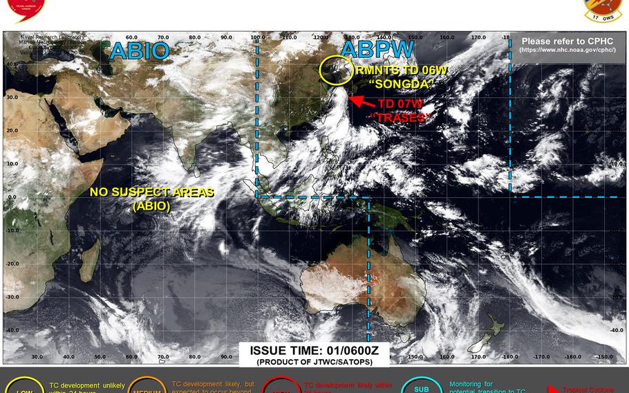
11:45 a.m. Monday, Aug. 1, Japan-Korea time: Say hello to the seventh numbered storm of the northwest Pacific’s tropical cyclone season.
Tropical Depression Trases spawned Monday morning north of Okinawa and west of Sasebo Naval Base, and appears headed quite rapidly toward Cheju Island and the west coast of the Korean peninsula, according to the Joint Typhoon Warning Center’s initial forecast track.
At 9 a.m., Trases was 229 miles south of Kunsan Air Base, trucking north at 23 mph, packing 35-mph sustained winds and 46-mph gusts. U.S. bases remain in seasonal Tropical Cyclone Conditions of Readiness.
JTWC projects Trases – Cambodian for woodpecker – to skim Korea’s west coast and dissipate within the next day or so. The local forecast calls for rain, heavy at times, mainly over the western portions of the peninsula, through Tuesday into Wednesday morning.
Meanwhile, JTWC has issued its final warning on Tropical Depression Songda, the remnants of which remain out over the Yellow Sea, where it’s forecast to dissipate in the coming hours.
At 9 a.m., it was 193 miles west of Kunsan, moving north-northeast at 6 mph with 29-mph sustained winds and 40-mph gusts at center.
***
3:30 a.m. Monday, Aug. 1, Japan-Korea time: A tropical cyclone formation alert has been issued for Tropical Disturbance 95W Invest by the Joint Typhoon Warning Center.
95W, labeled Tropical Storm Trases by Japan Meterological Agency, has a narrow window of about 18 hours or so to develop, and JTWC projects it to move quickly north and make landfall in the next day or so over the Korean Peninsula.
At 3 a.m., 95W Invest was 331 miles south-southwest of Sasebo Naval Base and trucking north-northwest at 20 mph, a fairly rapid clip, with the strongest winds, 35 to 40 mph, tucked into the east and northeast quadrants facing land, according to JTWC.
GFS forecast ensemble depicts landfall just past the DMZ, while the CMC ensemble favors landfall near Mokpo on Korea’s south coast.
As for Tropical Depression Songda, it continues to weaken as it heads northeast, possibly dissipating over the Yellow Sea in the next day or so.
***
11:30 p.m. Sunday, July 31, Japan-Korea time: The rain. So much rain. Though not a typhoon by any description, Tropical Disturbance 95W Invest provided a wealth of the wet stuff throughout Sunday afternoon, with more rain forecast into Monday.
At 9 p.m., 95W was 167 miles north-northwest of Kadena Air Base and following on Tropical Depression Songda’s heels toward the Yellow Sea. It remains a monsoon depression, much more a rain than wind event, though Japan Meteorological Agency has designated it Tropical Storm Trases (Cambodian for woodpecker).
Kadena’s and local Japanese forecasts call for more rain through Monday morning. U.S. bases on Okinawa remain in seasonal Tropical Cyclone Condition of Readiness 4.
Up north, Songda continues to degrade and, according to JTWC’s latest forecast track, could dissipate in the Yellow Sea before reaching the Korean Peninsula. Still, the local weather forecast calls for showers through Monday into Tuesday.
At 9 p.m., Songda was 222 miles west-southwest of Kunsan Air Base, crawling north at 5 mph, and had weakened to 29-mph sustained winds and 40-mph gusts at center.
***
5:30 p.m. Sunday, July 31, Japan-Korea time: While Tropical Depression Songda continues north into the Yellow Sea while struggling to stay alive … oh, have the heavens opened up over Okinawa, thanks to Tropical Disturbance 95W Invest.
95W, which at 3 p.m. was 34 miles south of Kadena Air Base, is more a rain event than a wind event, not yet a tropical cyclone. But the rain is coming down in buckets. Showers, heavy at times, along with isolated thunderstorms are forecast the rest of Sunday into Monday morning. And some gusty southerly winds, too.
As for Songda, it was 237 miles southwest of Kunsan Air Base, South Korea, crawling north-northeast at 5 mph and holding steady at 35-mph sustained winds and 46-mph gusts at center.
The system is degrading and according to Joint Typhoon Warning Center’s latest forecast track, it might dissipate over the Yellow Sea before making landfall. Still, the weather forecast for Korea’s west coast remains rainy into Tuesday morning.
***
6 a.m. Sunday, July 31, Japan-Korea time: Not much change in the last 12 hours. Tropical Depression Songda continues on its circuitous route north into the Yellow Sea, west of the Korean peninsula, while Tropical Disturbance 95W Invest, with its vast weather field, remains on a northerly path over Okinawa in Songda’s wake.
At 3 a.m., Songda was 236 miles southwest of Kunsan Air Base, moving north-northwest at 13 mph and holding steady at 35-mph sustained winds and 46-mph gusts at center.
As for 95W, the center of that disturbance, if it could be classified as a “center,” was 46 miles west of Kadena Air Base at 3 a.m.
But the system itself is a vast monsoon gyre, with gusts and showers stretching as far south as the Philippines and as far north as Songda’s south wind and rain bands.
Thus, while neither locale can expect anything close to a typhoon, local and military forecasts call for both Okinawa and for Korea’s west coast to endure showers, heavy at times, and gusty winds through Monday, with Korea’s nasty weather continuing into Tuesday. All locales remain in seasonal Tropical Cyclone Condition of Readiness.
***
7:15 p.m. Saturday, July 30, Japan-Korea time: Tropical Depression Songda has slowed slightly on its northwest journey toward the Yellow Sea. Joint Typhoon Warning Center projects it to strengthen to a tropical storm, then arc northeast toward landfall along the west coast of North Korea on Tuesday.
At 3 p.m., Songda was 139 miles southwest of Cheju Island, headed northwest at 13 mph, still packing 35-mph sustained winds and 46-mph gusts.
If it remains on current course, JTWC forecasts it to strengthen to 52-mph sustained winds and 63-mph gusts at center early Sunday morning, then gradually weaken as it arcs northeast. Landfall is forecast for about mid-morning Tuesday near Haeju, along North Korea’s west-central coast, as a tropical depression.
JTWC projects Songda to pass 104 miles northwest of Yongsan Garrison at about 8 a.m. Tuesday. Korea’s weather forecast calls for rain, heavy at times with gusty winds through the weekend into Tuesday.
To Okinawa’s south, Tropical Disturbance 95W Invest continues making its way north, with showers, heavy at times, isolated thunderstorms and gusty southerly winds forecast through the weekend into Monday. U.S. bases on Okinawa remain in seasonal Tropical Cyclone Condition of Readiness 4.
***
6 a.m. Saturday, July 30, Japan time: Tropical Depression Songda has weakened slightly as it continues heading west-northwest at a rather rapid clip headed for the Yellow Sea west of the Korean peninsula, according to the Joint Typhoon Warning Center.
At 3 a.m., Songda was 187 mile south-southwest of Sasebo Naval Base, moving west-northwest at 20 mph and had weakened to 29-mph sustained winds and 40-mph gusts. Joint Typhoon Warning Center continues to forecast Songda peaking at 40-mph sustained winds and 52-mph gusts as it heads into the Yellow Sea (West Sea) toward landfall near Haeju, North Korea, as a tropical depression.
Meanwhile, Tropical Disturbance 95W Invest remains a weak system which continues heading north, with model ensembles indicating it should pass near or over Okinawa in the next day or so, bringing a forecast of gusty southerly winds with isolated showers and thunderstorms over the weekend.
All locations remain in seasonal Tropical Cyclone Conditions of Readiness. Storm Tracker has the watch.
***
Midnight Friday, July 29, Japan time: Closest point of approach by Tropical Depression Songda to Okinawa has come and gone, according to Joint Typhoon Warning Center. But as that noted baseball philosopher Yogi Berra used to say, it ain’t over ‘til it’s over.
There’s another tropical disturbance south of Okinawa, 95W Invest, and though it, too, is not forecast to become anything major, Okinawa can expect clouds, gusts and rain, heavy at times, throughout the weekend and into next week as a result. Sorry about that, folks.
At 9 p.m., 95W was 342 miles south-southeast of Kadena Air Base and moving north-northwest at a fairly good clip. Model track guidance and the GFS and CMC forecast ensembles depict passage just to Okinawa’s east, while the ECMWF ensemble favors a track west-southwest of the island. Wait and see, this one’s about.
As for Songda, at 9 p.m., it was 234 miles south of Sasebo Naval Base, headed west-northwest at 22 mph, still packing 35-mph sustained winds and 46-mph gusts. Closest point of approach to Kadena was 267 miles north-northeast at about 10 p.m. Friday.
JTWC forecasts Songda to reach tropical-storm intensity, 40-mph sustained winds and 52-mph gusts, overnight Friday into Saturday, pass 217 miles south-southwest of Sasebo at 2 a.m. Saturday, head into the Yellow Sea (West Sea) west of the Korean peninsula and make landfall near Haeju on North Korea’s west-central coast late Tuesday evening.
In short, weather miserable enough to make for a wet, windy weekend, but not bad enough to give us that typhoon day off. Storm Tracker has the watch.
***
Noon Friday, July 29, Japan time: Say hello to the sixth numbered tropical cyclone of the northwest Pacific’s season.
What was 94W Invest has now morphed into Tropical Depression Songda, which at 9 a.m. was 382 miles east -northeast of Kadena Air Base, Okinawa, trucking northwest at 20 mph, with 35-mph sustained winds and 46-mph gusts at center.
U.S. bases on Okinawa and Fleet Activities Sasebo remain in seasonal Tropical Cyclone Condition of Readiness for both locales.
Joint Typhoon Warning Center doesn’t project a very long life for Songda. If it stays on present heading, Songda is forecast to remain at tropical-depression strength, 35-mph sustained winds and 46-mph gusts, passing 269 miles north-northeast of Kadena at midnight Friday and 209 miles south-southwest of Sasebo three hours later.
Keeping close watch on this, just in case Songda tries to misbehave more. Storm Tracker has the watch.
By the way, the name Songda stands for a river in northwestern Vietnam.
***
8 a.m. Friday, July 29, Japan time: Make that two tropical disturbances, almost co-located.
Joint Typhoon Warning Center has canceled its tropical cyclone formation alert on Tropical Disturbance 93W at 6 a.m. then an hour later issued one for Disturbance 94W Invest, which appears to have taken the torch of the dominant of the two invests.
At 3 a.m., 93W was 590 miles east-southeast of Kadena Air Base, Okinawa, while 94W was 483 miles due east. U.S. bases on Okinawa remain in seasonal Tropical Cyclone Condition of Readiness 4.
JTWC projects little development from either disturbance. Model track guidance and the GFS, CMC and ECMWF forecast ensembles depict northwest movement from 94W and passage north-northeast of Okinawa over the weekend.
Still not certain how close either may come or how strong either becomes. A confusing scenario, to say the least. And there’s another disturbance developing south of those, 95W Invest. Phew! Storm Tracker has the watch.
***
10:15 p.m. Thursday, July 28, Japan time: Tropical Disturbance 93W Invest remains in a struggle to develop, if not remain a disturbance altogether, as it keeps lurking well away from Okinawa.
At 9 p.m., 93W was 750 miles east-southeast of Kadena Air Base. U.S. bases on Okinawa remain in seasonal Tropical Cyclone Condition of Readiness 4.
Model track guidance and the GFS, CMC and ECMWF continue to remain in agreement on a northwest track, with passage north-northeast of Okinawa over the weekend.
But If current models and projections hold, 93W might not amount to much should it become a tropical cyclone. Still, it’s weather, and who knows what might happen in the coming days. Storm Tracker has the watch.
***
7:30 a.m. Thursday, July 28, Japan time: We’re still waiting for the other shoe to drop regarding Tropical Disturbance 93W Invest.
Joint Typhoon Warning Center re-issued its tropical cyclone formation alert at 7 a.m. Japan time. At 3 a.m., 93W was 949 miles east-southeast of Kadena Air Base and 477 miles northwest of Guam. U.S. bases on Okinawa remain in seasonal Tropical Cyclone Condition of Readiness 4.
Model track guidance, the GFS, CMC and ECMWF forecast ensembles remain in tight agreement on passage north-northwest of Okinawa. Questions still remain about how close and how strong 93W might become. Storm Tracker has the watch.
***
6:30 p.m. Wednesday, July 27, Japan time: Tropical Disturbance 93W Invest remains a goodly distance away from Okinawa and models continue to depict passage north-northeast of the island in the next few days with tropical cyclone development possible by the weekend.
At 3 p.m., 93W Invest was 1,052 miles southeast of Kadena Air Base and 270 miles northwest of Saipan. U.S. bases on Okinawa remain in seasonal Tropical Cyclone Condition of Readiness 4.
It remains uncertain how strong 93W might become and how close it might come to Okinawa should it become a tropical cyclone. Model track guidance, the GFS, CMC and ECMWF forecast ensembles still generally agree on northwest movement in the coming days. Storm Tracker has the watch.
***
6 a.m. Wednesday, July 27, Japan time: A tropical cyclone formation alert has been issued on tropical disturbance 93W Invest by the Joint Typhoon Warning Center.
93W Invest is just over a day old, and as of 3 a.m. Wednesday was 1,187 miles southeast of Kadena Air Base, Okinawa, and 237 miles northwest of Guam. U.S. bases in both locations remain in seasonal Tropical Cyclone Condition of Readiness 4.
Model track guidance and the GFS, CMC and ECMWF forecast ensembles are in general agreement on a northwest track in the vicinity of Okinawa and Amami Oshima about 200 miles north of Okinawa. But there remains a vast spread among model solutions longterm.
But it’s still very early in the game, too early to tell definitively where it might go, how close it might come to Okinawa – or Sasebo Naval Base – and how strong it might become. We’ll know more once JTWC issues a warning and a forecast track. Storm Tracker has the watch.
