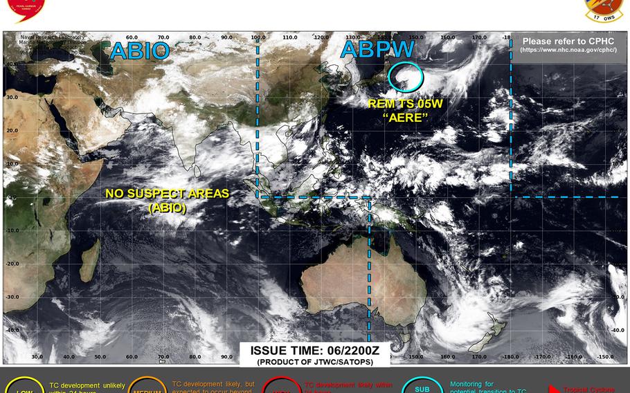
Aere strengthens into a tropical storm, forecast to dissipate east of Japan into the weekend. (Joint Typhoon Warning Center)
12:20 p.m. Thursday, July 7, Japan time: Joint Typhoon Warning Center issued its final warning on Aere as it became a tropical storm southeast of the Tokyo area. At 3 a.m., Aere was 286 miles east-southeast of Yokosuka Naval Base, moving east at 15 mph with 40-mph sustained winds and 52-mph gusts. JTWC’s final track depicts Aere turning north-northwest and dissipating over cooler waters and through strong vertical wind shear into the weekend. This is Storm Tracker’s final report on Aere.
***
11:40 p.m. Wednesday, July 6, Japan time: Now that Tropical Depression Aere is back out over open water in the northwest Pacific, it has actually strengthened slightly. A stubborn one, this one is.
And according to the Joint Typhoon Warning Center’s latest forecast track, Aere has a chance to regenerate into a tropical storm at mid-afternoon Thursday, but then gradually die out after that.
At 9 p.m., Aere was 205 miles east-southeast of Yokosuka Naval Base and 452 miles south-southeast of Misawa Air Base, moving east at 12 mph and had ticked up to 35-mph sustained winds and 46-mph gusts.
If Aere keeps on its present heading, JTWC projects it to keep moving east for another day, peaking at 40-mph sustained winds and 52-mph gusts at about 3 p.m. Thursday.
Aere is then forecast to make a sharp left turn northwest, rapidly weakening as it moves north and dissipating at mid-afternoon Sunday some 185 miles southeast of Misawa.
***
Noon Wednesday, July 6, Japan time: Marine Corps Air Station Iwakuni resumed seasonal Tropical Cyclone Condition of Readiness 5 at mid-morning Wednesday with Tropical Depression Aere moving out of the area.
Joint Typhoon Warning Center continues to project Aere hurtling quickly east, passing well south of the Tokyo area early Wednesday afternoon.
At 9 a.m., Aere was 140 miles south-southwest of Yokosuka Naval Base, speeding east at 22 mph and holding steady at 29-mph sustained winds and 40-mph gusts at center.
Yokosuka’s weather forecast calls for showers through Wednesday afternoon with northerly winds peaking at 18- to 23-mph sustained with 35-mph gusts Wednesday afternoon and evening into Thursday.
If Aere stays on present heading, JTWC forecasts it to remain well away from land, continue eastbound through mid-morning Friday, peaking at 40-mph sustained winds and 52-mph gusts at center, then turn sharply north Friday afternoon and dissipate off Japan’s northeast coast into the weekend.
***
Midnight Tuesday, July 5, Japan time: Tropical Depression Aere continues to hang in there, moving east on a Joint Typhoon Warning Center forecast track taking it just south of the Tokyo area late Wednesday.
Closest point of approach to Marine Corps Air Station Iwakuni has come and gone, though the base remained in Tropical Cyclone Condition of Readiness Storm Watch through Tuesday evening.
At 9 p.m., Aere was 84 miles southeast of Iwakuni, moving east at 13 mph, holding steady at 29-mph sustained winds and 40-mph gusts at center.
If Aere stays on present heading, JTWC projects it skim the south coasts of Shikoku and Honshu into Wednesday morning, moving back over open water at mid-morning, then restrengthen into a tropical storm, peaking at 46-mph sustained winds and 58-mph gusts at mid-evening and passing 98 miles south of Yokosuka Naval Base at 7 p.m. Wednesday.
JTWC forecasts Aere to then make a sharp left turn north at mid-evening Thursday, making secondary landfall east of Morioka early Sunday morning and passing just east of Misawa Air Base early Sunday evening, still packing 35-mph sustained winds and 46-mph gusts.
***
Noon Tuesday, July 5, Japan time: Tropical Depression Aere has exited the Sasebo Naval Base area, and the base resumed seasonal Tropical Cyclone Condition of Readiness 5 at 10:30 a.m. Marine Corps Air Station Iwakuni remains in TCCOR Storm Watch.
Aere is proving to be stubborn, if nothing else. At 9 a.m., Aere was 47 miles east of Sasebo, moving east-northeast at 12 mph with 29-mph sustained winds and 40-mph gusts, according to the Joint Typhoon Warning Center.
If Aere stays on present heading, it’s due to skim Shikoku and southern Honshu Island over the next 18 hours or so, passing 28 miles south of Iwakuni at about 4 p.m., then resume journey over water at mid-morning Wednesday, passing 58 miles south of Yokosuka Naval Base at mid-afternoon.
Long range, JTWC projects Aere to restrengthen into a tropical storm after passing south of the Tokyo area, make a left turn and head north before dissipating late this weekend about 120 miles east of Misawa Air Base.
***
1 a.m. Tuesday, July 5, Japan time: Little change. Tropical Depression Aere has weakened slightly, to 29-mph sustained winds and 40-mph gusts at center, and remains on course to pass 26 miles southeast of Sasebo Naval Base at 8 a.m. Tuesday and 21 miles southeast of Marine Corps Air Station Iwakuni 12 hours later. Sasebo remains in Tropical Cyclone Condition of Readiness Storm Watch.
***
3:30 p.m. Monday, July 4, Japan time: Happy Independence Day.
Boy, ol’ Aere simply doesn’t want to walk away quietly. We’re not expecting any significant fireworks from Aere, still a tropical depression as of Monday morning, but southwestern Japan and the Tokyo area can expect some gusty winds and scattered showers as Aere zooms through the area.
At 9 a.m., Aere was about 250 miles southwest of Sasebo Naval Base, moving northeast at 12 mph with 35-mph sustained winds and 46-mph gusts at center. Sasebo remained in Tropical Cyclone Condition of Readiness Storm Watch into Monday afternoon.
If Aere stays on present heading, Joint Typhoon Warning Center projects it to pass 32 miles southeast of Sasebo at mid-morning Tuesday, weaken slightly as it hurtles 15 miles southeast of Marine Corps Air Station Iwakuni at mid-evening Tuesday, then make its way back over water in the northwest Pacific Ocean after it passes 47 miles south of Yokosuka Naval Base at 11 p.m. Wednesday.
***
9:30 p.m. Sunday, July 3, Japan time: U.S. bases on Okinawa reverted to seasonal Tropical Cyclone Condition of Readiness 4 at 8:30 p.m., as announced by Kadena Air Base’s 18th Wing. Sasebo Naval Base remains in TCCOR Storm Watch as a precaution.
***
7:30 p.m. Sunday, July 3, Japan time: Aere has been downgraded to a tropical depression, continues moving north on course to pass through Japan’s main islands Tuesday and Wednesday, bringing a forecast of showers and gusty winds to Sasebo Naval Base, Marine Corps Air Station Iwakuni and the Tokyo area. Sasebo has directed Tropical Cyclone Condition of Readiness Storm Watch, while U.S. bases on Okinawa remain in TCCOR Storm Watch, just in case.
***
7:45 a.m. Sunday, July 3, Japan time: Though Tropical Storm Aere continues moving away from Okinawa, it’s those pesky backside wind and rain bands that are continuing to pelt the island with assorted nastiness, in the way of showers, some heavy, gusty winds and a bit of lightning hither and yon.
At 6 a.m., Aere was 71 miles northwest of Kadena Air Base, moving northwest at 13 mph. U.S. bases on Okinawa remained in Tropical Cyclone Condition of Readiness Storm Watch overnight Saturday into Sunday.
Kadena’s 18th Wing Weather Flight projects 29-mph sustained winds and 40-mph gusts for the island over the next several hours, courtesy of those peripheral rain bands. Japanese weather forecast calls for between a 50- and 80-percent chance of showers the rest of the day.
If Aere stays on present course, Joint Typhoon Warning Center projects it to gradually weaken and arc northeast, passing just south of Sasebo Naval Base at 7 a.m. Tuesday and Marine Corps Air Station Iwakuni 12 hours later as a tropical depression. Even the Tokyo area could feel some residual effects as Aere’s remnants pass through on Thursday.
***
2 a.m. Sunday, July 3, Japan time: Forecast closest point of approach by Tropical Storm Aere to Okinawa has come and gone. That said, there’s still plenty of wind and rain to come thanks to Aere’s backside rain and windbands.
Aere made landfall over Kayo on Okinawa’s northeast coast, 37 miles east-northeast of Kadena Air Base, at about midnight, according to Kadena’s 18th Wing Weather Flight. Joint Typhoon Warning Center’s latest forecast indicated Aere peaked at 46-mph sustained winds and 58-mph gusts as it made landfall.
U.S. bases on Okinawa remained in Tropical Cyclone Condition of Readiness Storm Watch through Saturday evening into Sunday morning.
The overnight forecast calls for showers, heavy at times, with isolated thunderstorms, through Sunday and continuing on and off into Monday.
If Aere keeps on its present heading, Joint Typhoon Warning Center projects it to weaken as it moves north, then make a right turn and pick up speed as it passes over Sasebo Naval Base at 2 p.m. Tuesday and Marine Corps Air Station Iwakuni 14 hours later as a tropical depression.
***
8:15 p.m. Saturday, July 2, Japan time: We’re starting to feel the effects of Tropical Storm Aere in the form of showers and high winds. The heaviest is forecast for early Sunday morning as Aere passes Okinawa to the east-northeast and the backside wind and rain bands smack the island.
At 6 p.m., Aere was about 92 miles southeast of Kadena Air Base and moving at a fast clip, north-northwest at 18 mph, holding steady at 52-mph sustained winds and 63-mph gusts. The east quadrants typically the worst of the four, should remain off shore as Aere passes 58 miles east-northeast of the island at about 10 p.m., according to the Joint Typhoon Warning Center’s latest forecast track.
Here is the latest wind-forecast timeline for Aere from Kadena’s 18th Wing Weather Flight. U.S. bases on Okinawa remain in Tropical Cyclone Condition of Readiness Storm Watch. Between 1 to 3 inches of rain are forecast:
-- Onset of 40-mph sustained winds: Began at 7:30 p.m.
-- Onset of 58-mph sustained winds: Not forecast at this time.
-- Peak 52-mph sustained winds and 63-mph gusts for Okinawa, 46-mph sustained winds and 58-mph gusts for Kadena: Midnight.
-- Sustained winds subsiding below 40 mph: 6 a.m. Sunday.
If Aere remains on current heading, JTWC projects it to peak at 58-mph sustained winds and 75-mph gusts after making closest point of approach, move north into cooler waters where it will gradually weaken, then make a sharp right turn, passing over Sasebo Naval Base at 2 p.m. Tuesday and Marine Corps Air Station Iwakuni 12 hours later as a tropical depression. More to follow.
***
1:30 p.m. Saturday, July 2, Japan time: Won’t be long now. Showers, isolated thunderstorms and gusty winds set to pick up Saturday afternoon and evening on into Sunday morning. The heaviest of winds should be off shore of Okinawa to the east-northeast, but it should still be quite a messy weekend.
Here is the latest wind-forecast timeline for Aere from Kadena Air Base’s 18th Wing Weather Flight. U.S. bases on Okinawa remain in Tropical Cyclone Condition of Readiness Storm Watch. Between 2 and 3 inches of rain associated with Aere are forecast:
-- Onset of 35-knot (40-mph) sustained winds: 7 p.m. Saturday.
-- Onset of 50-knot (58-mph) sustained winds: Not forecast at this time.
-- Peak 45-knot (52-mph) sustained winds, 55-knot (63-mph) gusts for Okinawa, 40-knot (46-mph) sustained winds, 50-knot (58-mph) gusts for Kadena: Midnight Saturday.
-- Winds subsiding below 35-knot (40-mph) sustained: 6 a.m. Sunday.
At 9 a.m., Tropical Storm Aere was 208 miles southeast of Kadena and it had put the pedal to the metal, moving north-northwest at 18 mph, holding steady at 52-mph sustained winds and 63-mph gusts at storm’s center.
If Aere continues on present heading, Joint Typhoon Warning Center projects it to peak at 58-mph sustained winds and 75-mph gusts, with the worst of it in the east quadrants, off the coast for the most part. JTWC projects closest point of approach to be 40 miles east-northeast of Kadena at 11 p.m. Saturday.
Once past Okinawa, Aere is forecast to keep moving northwest for another day, then start to weaken as it curves northeast, passing just south of Sasebo Naval Base at 2 p.m. Tuesday and Marine Corps Air Station Iwakuni 15 hours later as a weak tropical storm or tropical depression.
***
7:30 a.m. Saturday, July 2, Japan time: As Tropical Storm Aere closes in on Okinawa, little has changed regarding forecast wind speeds and rainfall for the island in the coming two days.
Here is the latest wind-forecast timeline for Aere from Kadena Air Base’s 18th Wing Weather Flight. U.S. bases on Okinawa remain in Tropical Cyclone Condition of Readiness Storm Watch. Between 1 and 3 inches of rain associated with Aere are forecast:
-- Onset of 35-knot (40-mph) sustained winds: 6 p.m. Saturday.
-- Onset of 50-knot (58-mph) sustained winds: Not forecast at this time.
-- Peak 45-knot (52-mph) sustained winds, 55-knot (63-mph) gusts for Okinawa, 40-knot (46-mph) sustained winds, 50-knot (58-mph) gusts for Kadena: 1 a.m. Sunday.
-- Winds subsiding below 35-knot (40-mph) sustained: Noon Sunday.
Weather Flight officials forecast the strongest winds for northeastern Okinawa between 11 p.m. Saturday and 3 a.m. Sunday.
At 3 a.m., Aere was 306 miles southeast of Kadena, headed north-northwest at 12 mph and had strengthened slightly, to 52-mph sustained winds and 63-mph gusts at center.
If Aere stays on present course, Joint Typhoon Warning Center projects it to pass 29 miles east-northeast of Kadena at midnight Saturday, packing 63-mph sustained winds and 81-mph gusts at center.
From there, Aere is forecast to gradually weaken as it heads north through cooler waters, curve northeast and pass almost directly over Sasebo Naval Base at 4 p.m. Tuesday and Marine Corps Air Station Iwakuni 15 hours later as either a weak tropical storm or tropical depression. More to follow.
***
12:30 a.m. Saturday, July 2, Japan time: Tropical Storm Aere’s forecast track has edged a bit further east again, taking its Joint Typhoon Warning Center forecast closest point of approach a bit further away from U.S. bases on Okinawa.
At 9 p.m., Aere was 366 miles southeast of Kadena Air Base and had put the foot down on the gas pedal some, moving north at 14 mph, holding steady at 46-mph sustained winds and 58-mph gusts at center.
U.S. bases on Okinawa remained in Tropical Cyclone Condition of Readiness Storm Watch through Friday evening into Saturday morning.
If Aere stays on present course, JTWC projects it to strengthen to 58-mph sustained winds and 75-mph gusts as it curves northwest, then passes 43 miles east-northeast of Kadena, over Cape Hedo at the island’s northeastern end, at 2 a.m. Sunday.
From there, Aere is forecast to peak at 63-mph sustained winds and 81-mph gusts at mid-evening Sunday, then arc northeast, gradually losing its punch as it grazes the northwest coasts of Kyushu and Honshu Islands in southwestern Japan, passing 29 miles northwest of Sasebo Naval Base at 1 p.m. Tuesday and 52 miles northwest of Marine Corps Air Station Iwakuni 15 hours later. More to follow.
***
8:15 p.m. Friday, July 1, Japan time: Here’s the latest wind-forecast timeline for Tropical Storm Aere from Kadena Air Base’s 18th Wing Weather Flight. U.S. bases on Okinawa remain in seasonal Tropical Cyclone Condition of Readiness 4. Between 1 and 3 inches of rain is forecast.
-- Onset of sustained 35-knot (40-mph) winds: 6 p.m. Saturday.
-- Onset of sustained 50-knot (58-mph) winds: Not forecast at this time.
-- Peak sustained 45-knot (52-mph) winds, 55-knot (63-mph) gusts for Okinawa, sustained 40-knot (46-mph) winds, 50-knot (58-mph) gusts for Kadena: 3 a.m. Sunday.
-- Sustained winds subsiding below 35-knot (40-mph): Noon Sunday.
Joint Typhoon Warning Center projects closest point of approach by Aere to Kadena to be 29 miles east-northeast at 3 a.m. Sunday. Showers and isolated thunderstorms are expected throughout the forecast period into Monday.
At 3 p.m., Aere was 436 miles south-southeast of Kadena, heading north at 7 p.m. and had strengthened slightly, to 46-mph sustained winds and 58-mph gusts at center. Aere is forecast to peak at 58-mph sustained winds and 75-mph gusts as it makes closest point of approach.
From there, JTWC projects Aere to arc gradually north to northeast through the Tsushima Strait between Korea’s southeast coast and southwestern Japan, passing 39 miles northwest of Sasebo Naval Base and 66 miles southeast of Pusan as a mild tropical storm, 40-mph sustained winds and 52-mph gusts. More to follow.
***
2:15 p.m. Friday, July 1, Japan time: Here is the initial wind-forecast timeline for Tropical Storm Aere courtesy of Kadena Air Base’s 18th Wing Weather Flight. U.S. bases on Okinawa remain in seasonal Tropical Cyclone Condition of Readiness 4. Between 1 and 3 inches of rain is forecast.
-- Onset of sustained 35-knot (40-mph) winds: 9 p.m. Saturday.
-- Onset of sustained 50-knot (58-mph) winds: Not forecast at this time.
-- Peak sustained 45-knot (52-mph) winds, 63-mph gusts for Okinawa, sustained 40-knot (46-mph) winds, 50-knot (58-mph) gusts for Kadena: 2 a.m. Sunday.
-- Sustained winds subsiding below 35-knot (40-mph): Noon Sunday.
Joint Typhoon Warning Center projects closest point of approach by Aere to Kadena to be 20 miles east-northeast at 2 a.m. Sunday. Showers and isolated thunderstorms are forecast throughout the forecast period into Monday.
***
12:30 p.m. Friday, July 1, Japan time: Aere has been upgraded to a tropical storm, has lurched a bit east, but remains on track to pass over Okinawa early Sunday morning as a severe tropical storm, according to the Joint Typhoon Warning Center’s latest forecast.
At 9 a.m., Aere was 470 miles south-southeast of Kadena Air Base, moving east-northeast at 9 mph and had strengthened to 46-mph sustained winds and 58-mph gusts at center. U.S. bases on Okinawa remained in seasonal Tropical Cyclone Condition of Readiness 4 through Friday morning into early afternoon.
If Aere continues on its present course, JTWC projects it to resume a northwesterly path, pass 20 miles east-northeast of Kadena at 1 a.m. Sunday packing 63-mph sustained winds and 81-mph gusts at storm’s center.
After moving north of Okinawa, Aere is forecast to peak at 69-mph sustained winds and 86-mph gusts – just shy of Category 1-equivalent typhoon strength.
Aere is projected to weaken rapidly as it moves further north, making landfall over the south coast of the Korean peninsula at mid-afternoon Tuesday as a tropical storm, degrading further as it moves inland. More to come.
***
7 a.m. Friday, July 1, Japan time: Tropical Depression 05W has strengthened slightly and remains on course to pass over Okinawa at mid-evening Saturday as a tropical storm.
At 3 a.m., 05W was 480 miles south-southeast of Kadena Air Base, moving northwest at 5 mph with 35-mph sustained winds and 46-mph gusts. U.S. bases on Okinawa remained in seasonal Tropical Cyclone Condition of Readiness 4 overnight Thursday into Friday.
Should 05W stay on present heading, Joint Typhoon Warning Center projects it to keep moving north-northwest, peak at 58-mph sustained winds and 75-mph gusts at mid-afternoon Saturday, just before passing 6 miles east-northeast of Kadena at about 7 p.m. Saturday.
Kadena’s 18th Wing Weather Flight forecast continues to call for showers and isolated thunderstorms throughout the July 4th weekend, with tropical-storm conditions Friday afternoon and evening into Saturday, east to southeasterly 20-mph winds and 40-mph gusts.
Once past Okinawa, 05W is forecast to gradually weaken, move due north and then northeast, grazing the southeast coast of the Korean peninsula, passing over Kimhae International Airport at mid-afternoon Tuesday as a tropical depression.
Model-track guidance is a bit varied, while the GFS and CMC forecast ensembles generally agree on a track similar to that of JTWC. More to follow.
***
12:45 a.m. Friday, July 1, Japan time: As we bid June a fond farewell and enter the Independence Day holiday weekend, we welcome the fifth numbered tropical cyclone of the northwest Pacific’s typhoon season. And it appears on target to pass over Okinawa this weekend as a mid-range tropical storm.
At 9 p.m., 05W was 535 miles south-southeast of Kadena Air Base, headed north-northwest at 5 mph, with 29-mph sustained winds and 40-mph gusts at center. U.S. bases on Okinawa remained in seasonal Tropical Cyclone Condition of Readiness 4 through Thursday evening into Friday.
Kadena’s 18th Wing Weather Flight forecast calls for tropical-storm conditions Friday evening into Saturday morning, with easterly winds of 20 mph gusting to 40 mph Friday afternoon and evening, shifting southerly Saturday morning. Isolate rain showers are forecast the rest of the July 4th weekend.
If 05W continues on present course, Joint Typhoon Warning Center projects it to pass 13 miles east-northeast of Kadena at 2 p.m. Saturday, packing 52-mph sustained winds and 63 mph gusts at center. Model-track guidance and the GFS forecast ensemble best track concur with a track over Okinawa.
JTWC forecasts it to peak at 58-mph sustained winds and 75-mph gusts at mid-evening Saturday just after closest point of approach to Okinawa, then diminish gradually as it heads north and northeast through the Tsushima Straits as a tropical depression late Tuesday evening.
If 05W becomes a named storm, it would be called Aere, which stands for … wait for it … storm. You can’t make up stuff like that.
***
2 p.m. Thursday, June 30, Japan time: Looks like it could be one of those on-and-off rainy-type next couple of days, with heavy day-long rain possible Saturday and Sunday, the peak of the July 4th Independence Day weekend.
U.S. bases on Okinawa remain in seasonal Tropical Cyclone Condition of Readiness 4. Regarding 98W Invest, Kadena Air Base's 18th Wing Weather Flight says for the moment, it appears it may be more of a rain than wind event, they're not expecting to accelerate TCCOR; but prudent to bear in mind, that can change at any time. This is weather we're talking.
Here are what the GFS and ECMWF forecast ensembles are showing regarding 98W Invest. In basic agreement on a zig-zag walk northwest, with something of a spread among solutions.
For now, expect showers and isolated thunderstorms through the rest of Thursday into Friday. Already, we’ve seen masses of those type of clouds moving our way from the southeast. As one once told me in my early years in the Pacific and my first couple of visits to Okinawa, if you don’t like the weather, wait five minutes.
2 a.m. Thursday, June 30, Japan time: The picture is coming into better focus regarding tropical disturbance 98W Invest and proximity to Okinawa this coming weekend.
The bad news: It does appear as though it should pass close if not directly over the island. The good news: For the moment, it doesn’t look like it could be a knock-down, drag-out typhoon, though this is weather we’re talking.
Here is what the GFS, CMC and ECMWF model ensembles are projecting. It’s still a young disturbance and these might change, though the Joint Typhoon Warning Center reports that the ensembles are in tight agreement. Here are the Kadena Air Base 18th Wing Weather Flight and local Japanese forecasts.
U.S. bases on Okinawa remain in seasonal Tropical Cyclone Condition of Readiness 4. That may or may not change, depending on forecast winds. If we’re looking at winds of 58 mph or greater, yes, we could see accelerated TCCORs.
That is up to the forecast and any TCCOR calls made by the 18th Wing commanding officer, who speaks in one voice for the island regarding TCCORs.
***
9 p.m. Wednesday, June 29, Japan time: A tropical disturbance, labeled 98W Invest, is developing south-southeast of Okinawa. Joint Typhoon Warning Center reports that at 8 p.m., 98W was 675 miles south-southeast of Kadena Air Base and forecast to track northwest while gradually developing over the next day to two days. It’s far too early to tell how strong it might become as it heads northwest. Model track guidance shows it coming close to Okinawa. Military and Japanese forecasts call for showers and isolated thunderstorms during the upcoming July 4th Independence Day weekend. More to follow.
