Malakas passes closest point of approach regarding Guam, Saipan, continues on northwest course over open water. (Joint Typhoon Warning Center)
4 p.m. Sunday, April 10, Guam time: Closest point of approach to Guam and Saipan regarding Tropical Storm Malakas has come and gone. Malakas continues on a northwest course over open water; the latest Joint Typhoon Warning Center forecast track doesn’t have it threatening any land masses at this point. Assuming it remains that way, this is Storm Tracker’s final report on Malakas.
***
12:30 a.m. Sunday, April 10, Guam time: Not much change since the last report. Tropical Storm Malakas continues tracking northwest and Guam remains well out of harm’s way, according to the Joint Typhoon Warning Center.
At 10 p.m. Saturday, Malakas was 370 miles south-southwest of Guam and 500 south-southwest of Saipan, headed northwest at 10 mph, packing 52-mph sustained winds and 63-mph gusts, according to -JTWC and the National Weather Service. Tropical storm-force winds extend 70 miles to the south of center and 90 miles north, NWS reports.
If Malakas stays on present heading, JTWC projects it to keep heading northwest, passing 348 miles southwest of Andersen Air Force Base and 324 southwest of Naval Base “Big Navy” as a severe tropical storm, packing 58-mph sustained winds and 75-mph gusts.
Guam remains just outside JTWC’s probability cone, no watches or warnings are in effect for the island and U.S. bases on Guam remain in seasonal Tropical Cyclone Condition of Readiness 4.
***
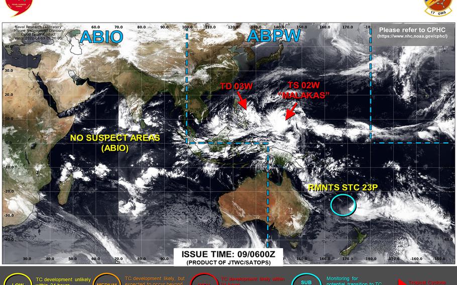
7:50 p.m. Saturday, April 9, Guam time: Very gradually, Tropical Storm Malakas is strengthening and continues to head northwest on a Joint Typhoon Warning Center forecast track taking well southwest of Guam early Sunday morning.
At 4 p.m., Malakas was 410 miles south of Guam, headed northwest at 6 mph, according to the National Weather Service on Guam. No watches or warnings are up for the island and U.S. bases on Guam remain in seasonal Tropical Cyclone Condition of Readiness 4.
If Malakas remains on present heading, JTWC projects it to pass 355 miles southwest of Andersen Air Force Base and 331 miles southwest of Naval Base “Big Navy” at about 6 a.m. Sunday as a severe tropical storm. While not expected to directly threaten the island, Guam could receive gusty southeasterly winds and isolated showers as Malakas passes.
***
1 a.m. Saturday, April 9, Guam time: Tropical Storm Malakas continues building strength, but remains on course to pass more than 300 miles southwest of Guam early Sunday morning, according to the Joint Typhoon Warning Center.
At 10 p.m., Malakas was 520 miles south of Andersen Air Force Base, moving north-northwest at 7 mph and had strengthened to 46-mph sustained winds and 58-mph gusts, JTWC reports. Tropical storm-force winds extend outward from center up to 145 miles south and 115 north, according to the National Weather Service on Guam.
No warnings or watches are in effect for Guam, NWS reports. U.S. bases on Guam remain in seasonal Tropical Cyclone Condition of Readiness 4.
If Malakas stays on present course, JTWC projects it to pass 309 miles southwest of Naval Base “Big Navy” and 334 southwest of Andersen between 5 and 6 a.m. Sunday as a severe tropical storm, 69-mph sustained winds and 86-mph gusts.
From there, Malakas is forecast to keep tracking northwest, then curve northeast in the general direction of Iwo Jima, well southeast of Okinawa by middle of next week.
***
1 p.m. Friday, April 8, Guam time: 02W has strengthened into a tropical storm and has acquired a name, Malakas, which is Tagalog (Philippines) for strong. And the name could well befit Malakas according to the latest from Joint Typhoon Warning Center.
At 10 a.m., Malakas was 590 miles south of Guam, moving north-northwest at 8 mph and had strengthened to 40-mph sustained winds and 52-mph gusts at center, according to the National Weather Service on Guam. Tropical storm-force winds extend up to about 40 miles northeast of center.
With the strongest wind and rain bands currently in the northeast quadrant, if Malakas continues on present course, Guam could be on the receiving end of some gusty southeasterly winds and rain squalls – the latter which the island really needs at this point.
Still, the island should be spared Malakas’ worst; JTWC projects it to pass well southwest, 289 miles from Naval Base “Big Navy” and 313 from Andersen Air Force Base, packing Category 1-equivalent force, 81-mph sustained winds and 98-mph at center at mid-afternoon Sunday, then keep heading northwest into next week.
Way too soon to say definitively whether it might or might not affect Okinawa; model-track guidance and best tracks have Malakas curving northeast and passing well southeast of the island. Storm Tracker has the watch.
***
7:45 p.m. Thursday, April 7, Guam time: The news gets better for Guam as Tropical Depression 02W’s latest Joint Typhoon Warning Center forecast track takes it further southwest of the island than previously reported.
At 4 p.m., 02W was 669 miles south-southeast of Guam’s capital of Hagatna, traveling west-northwest at 9 mph and had strengthened to 35-mph sustained winds and 46-mph gusts, according to the National Weather Service on Guam. U.S. bases on Guam remain in seasonal Tropical Cyclone Condition of Readiness 4.
If 02W stays on present course, JTWC projects it to keep gradually curving northwest, strengthen in to a tropical storm by mid-afternoon Friday, then become a Category 1-equivalent typhoon at mid-afternoon Sunday.
JTWC forecasts 02W to pass 340 miles southwest of Andersen Air Force Base and 315 miles southwest of Naval Base “Big Navy” at about 1 p.m. Sunday as a Category 1-equivalent typhoon. A tad further southwest than previously reported.
That’s better news than before. Still, this is a young storm with plenty of possibilities, as the spread among model track guidance and solutions is rather vast. Stay tuned. Storm Tracker has the watch.
***
2 p.m. Thursday, April 7, Guam time: Tropical Depression 02W spawned overnight south-southeast of Guam, and according to the Joint Typhoon Warning Center’s initial warning, it could pass a little more than 200 miles southwest of the island early next week.
At 10 a.m., 02W was 736 miles south-southeast of Andersen Air Force Base, heading west-northwest at 9 mph with 29-mph sustained winds and 40-mph gusts at center. U.S. bases on Guam remain in seasonal Tropical Cyclone Condition of Readiness 4.
If 02W stays on current heading, JTWC projects it to gradually curve northwest, strengthen into a tropical storm by mid-morning Friday, then become a Category 1-equivalent typhoon at mid-morning Sunday, passing 252 miles southwest of Andersen and 228 southwest of Naval Base “Big Navy” early Monday morning.
A word of advice: It’s very early in the life of a young storm. Much can change as 02W develops and the best tracks become more defined. Storm Tracker has the watch.
***
5 a.m. Thursday, April 7, Guam time: A tropical cyclone formation alert was issued for tropical disturbance 95W Invest just after midnight by the Joint Typhoon Warning Center. It’s possible the disturbance could become a tropical cyclone later Thursday and pass relatively close to Guam in the coming days.
At 4:30 a.m., 95W was 690 miles south-southeast of Guam. Current model track guidance indicates close passage to Guam in the next three to four days, while the Global Forecast System best track has it splitting the difference between Yap and Guam in the coming days.
Too soon to say exactly what it might do. Storm Tracker has the watch.
