Storm Signal 8 lowered, Strong Wind Signal 3 raised for Hong Kong as Kompasu keeps moving west toward Vietnam. (Joint Typhoon Warning Center)
5 p.m. Wednesday, Oct. 13, Hong Kong time: Storm Signal 8 has been lowered, replaced by Strong Wind Signal 3 at 4:40 p.m. by the Hong Kong Observatory, as Tropical Storm Kompasu has made landfall over Hainan Island and keeps moving west toward Vietnam.
And finally, the skies have cleared over Okinawa after several days of rain, heavy at times, though the easterly winds and gusts remain, as they have for more than a week now. Local forecasts call for sunshine to remain at least entering the weekend.
At 4 p.m., Kompasu was 322 miles southwest of Hong Kong, moving west at 22 mph and holding steady at 63-mph sustained winds and 81-mph gusts.
Joint Typhoon Warning Center’s latest forecast track indicates passage into the Gulf of Tonkin and secondary landfall 124 miles south of Hanoi, Vietnam, at about midday Thursday. This is Storm Tracker’s final report on Kompasu.
8:30 p.m. Tuesday, Oct. 12, Hong Kong time: Northeast Storm Signal 8 was issued at 5:20 p.m. by the Hong Kong Observatory as Tropical Storm Kompasu continues moving west through the South China Sea. HKO reports that Signal 8 is expected to remain in force through at least before sunrise Wednesday.
Joint Typhoon Warning Center’s forecast track shows Kompasu continuing to pick up speed and passing 242 miles south of Hong Kong early Wednesday morning. But its wind field continues to be vast, with gusts as high as 60 mph recorded at Tate’s Caim, Waglan Island and Cheung Chau. HKO reporters that Kompasu’s outer bands are expected to bring showers and squalls overnight.
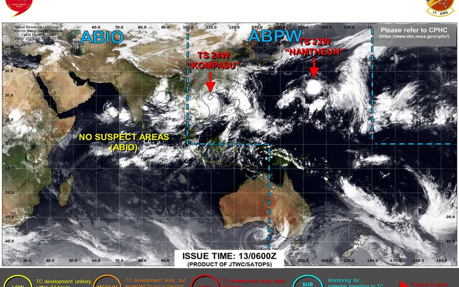
At 2 p.m., Kompasu was 317 miles southeast of Hong Kong, hurtling west at 18 mph and holding steady at 63-mph sustained winds and 81-mph gusts at center. The wind field remains huge, as much as 700 miles in diameter, with spiral bands stretching as far as the Formosa Strait and southern Luzon in the Philippines.
Okinawa continues to experience showers, some heavy at times, with easterly to southeasterly winds forecast to peak at 23-mph sustained and 31-mph gusts Wednesday afternoon and evening, according to Kadena’s extended weather forecast. U.S. bases on Okinawa remain in seasonal Tropical Cyclone Condition of Readiness 4, and sea condition has been scaled back to East-West Caution.
***
11:30 a.m. Tuesday, Oct. 12, Japan time: Tropical Storm Kompasu continues its westward journey into the South China Sea. Though destructive winds remain hundreds of miles away from Okinawa, the island can continue to expect blustery, gusty, showery conditions through Wednesday, according to military and local Japanese forecasts.
At 9 a.m., Kompasu was 313 miles north-northwest of Metro Manila and 756 southwest of Kadena Air Base, Okinawa, moving due west at 14 mph, packing 63-mph sustained winds and 81-mph gusts at center.
U.S. bases on Okinawa remain in seasonal Tropical Cyclone Condition of Readiness 4. Sea condition remains East-West Danger.
Kadena’s extended forecast calls for showers and isolated thunderstorms through Wednesday, with easterly winds peaking at 22-mph sustained and 31-mph gusts; Japanese weather forecasts concur.
Kompasu’s wind field and outer rain bands simply stretch far enough that Okinawa continues to feel some effect, though nothing typhoony. Clearing skies are expected by Thursday.
***
6 p.m. Monday, Oct. 11, Japan time: Tropical Storm Kompasu keeps moving away from Japan’s southwestern-most islands, according to Joint Typhoon Warning Center. But Kompasu’s wind field remains quite vast, and though destructive winds are not forecast for Okinawa, expect some blustery, gusty, showery conditions over the next couple of days.
At 3 p.m., Kompasu was 577 miles south-southwest of Kadena Air Base, Okinawa, and 328 miles north-northeast of Metro Manila, moving west-northwest at 12 mph and holding steady at 58-mph sustained winds and 75-mph gusts at center.
U.S. bases on Okinawa are in seasonal Tropical Cyclone Condition of Readiness 4 and should remain that way unless Kompasu reverses course and heads in Okinawa’s direction, which is most unlikely. Sea condition for Okinawa is East-West Danger.
Kadena’s extended weather forecast calls for up to a 70-percent chance of showers and scattered thunderstorms through Tuesday, with easterly winds peaking at 26-mph sustained and 37-mph gusts Tuesday afternoon and evening.
If Kompasu remains on present course, JTWC forecasts it to skim Luzon’s north coast, peak at 69-mph sustained winds and 86-mph gusts at mid-afternoon Tuesday as it traverses the South China Sea, weakening gradually as it reaches Hainan Island Wednesday evening and make secondary landfall over Vietnam overnight Thursday into Friday.
***
1 a.m. Monday, Oct. 11, Japan time: Tropical Storm Kompasu has begun arcing northwest and has strengthened some over the last several hours. Joint Typhoon Warning Center’s latest forecast track continues taking it west through the Babuyan Islands late Monday, the South China Sea, over Hainan Island late Wednesday and make secondary landfall over Vietnam at mid-afternoon Thursday.
At 9 p.m. Sunday, Kompasu was 454 miles northeast of Metro Manila and 518 miles south of Kadena Air Base, Okinawa, moving northwest at 17 mph and packing 52-mph sustained winds and 63-mph gusts at center.
U.S. bases on Okinawa remain in seasonal Tropical Cyclone Condition of Readiness 4 and sea condition is East West Danger. Kadena’s extended forecast calls for easterly winds the next several days, peaking at -30-mph sustained with 42-mph gusts Monday afternoon and up to a 70-percent chance of showers and scattered thunderstorms through mid-day Wednesday.
***
5:40 p.m. Sunday, Oct. 10, Japan time: Tropical Storm Kompasu is up and operating in the northern Philippine Sea. While it doesn’t appear to be a direct threat to any U.S. facilities in Japan, the forecast for mid-week on Okinawa calls for blustery, gusty conditions and plenty of rain, heavy at times.
At 3 p.m., Kompasu was 588 miles south of Kadena Air Base, Okinawa, and 499 east-northeast of Metro Manila, moving north-northwest at 10 mph with 40-mph sustained winds and 52-mph gusts at center.
U.S. bases on Okinawa are in seasonal Tropical Cyclone Condition of Readiness 4 and should remain that way unless there’s a drastic change in Kompasu’s Joint Typhoon Warning Center forecast track.
That calls for Kompasu to curve west and make a beeline for the Babuyan Islands just north of Luzon in the Philippines and southern Taiwan as a Category 1-equivalent typhoon on Monday, then keep heading west through Hainan Island in southeastern Japan and make secondary landfall at mid-afternoon Thursday in Vietnam.
Kompasu is Japanese for that v-shaped compass that elders used in geometry class years ago.
