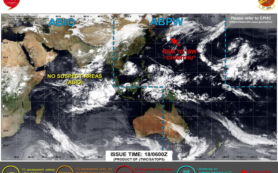
Chanthu forecast to die out southeast of Tokyo, brings to an end what at one time was the strongest tropical system in the world this year. (Joint Typhoon Warning Center)
3:30 p.m. Saturday, Sept. 18, Japan time: Joint Typhoon Warning Center has issued its final warning on Chanthu, which at one time a week ago was the strong tropical system in the world this calendar year. JTWC projects Chanthu to keep moving rapidly, following the south coast of Honshu and dying out southeast of Tokyo in the Pacific Ocean. This concludes Storm Tracker’s coverage of Chanthu.
***
7 a.m. Saturday, Sept. 18, Japan time: Chanthu has been downgraded to a tropical depression by Joint Typhoon Warning Center as it continues its beeline east over Japan’s main Honshu Island. Though it’s not much of a wind event, heavy rain is forecast to soak Honshu, especially in the major metropolitan areas, throughout Saturday.
At 3 a.m., Chanthu was 322 miles west-southwest of Yokosuka Naval Base, moving rapidly east at 26 mph with 35-mph sustained winds and 46-mph gusts at center.
If Chanthu remains on present heading, JTWC forecasts it to keep accelerating each, weakening as it moves and passing 70 miles south of Yokosuka at 10 p.m. Saturday. A final wrapup coming at about midnight Saturday.
***
11:40 p.m. Friday, Sept. 17, Japan time: Tropical Storm Chanthu is making its way just south of Marine Corps Air Station Iwakuni, which remains under Tropical Cyclone Condition of Readiness Storm Watch. Joint Typhoon Warning Center projects it to move rapidly through the Seto Inland Sea between Honshu and Shikoku, passing just south of Tokyo and the Kanto Plain late Saturday into Sunday.
At 9 p.m., Chanthu was 48 miles southwest of Iwakuni and had put the hammer down, moving east at 23 mph, holding steady at 46-mph sustained winds and 58-mph gusts.
If Chanthu stays on present heading, JTWC forecasts it to move quickly through the Kansai region (Osaka, Nagoya), weakening steadily as it moves, then pass 45 miles south of Yokosuka Naval Base at 5 a.m. Sunday as a tropical depression before dissipating out at sea.
***
5:30 p.m. Friday, Sept. 17, Japan time: Weaker, ever weaker, Tropical Storm Chanthu is becoming as it makes its way over land in Kyushu, just north of Sasebo Naval Base, according to the Joint Typhoon Warning Center.
At 3 p.m., Chanthu was 36 miles northwest of Sasebo and has put the pedal to the metal, moving east-northeast at 17 mph and had weakened to 46-mph sustained winds and 58-mph gusts at center. Sasebo remains in Tropical Cyclone Condition of Readiness 1 and Marine Corps Air Station Iwakuni remains in TCCOR Storm Watch.
If Chanthu remains on present course, JTWC projects it to keep moving generally east, passing 10 miles north of Iwakuni, then weaken to a tropical depression and pass 46 miles south of Yokosuka Naval Base. Weather forecasts for Sasebo and Yokosuka remain the same.
***
11:30 a.m. Friday, Sept. 17, Japan time: One change on the TCCOR scoreboard: Naval Base Chinhae has resumed seasonal Tropical Cyclone Condition of Readiness 5 for Chinhae, Pusan and other areas along Korea’s south coast. Sasebo Naval Base remains in TCCOR 1 and Marine Corps Air Station Iwakuni in TCCOR Storm Watch.
At 9 a.m., Chanthu was 128 miles west of Sasebo, headed east at xx mph with 58-mph sustained winds and 75-mph gusts at center.
If Chanthu stays on present heading, Joint Typhoon Warning Center projects it to weaken slightly to 52-mph sustained winds and 63-mph gusts as it comes ashore and passes 17 miles north-northwest of Sasebo at 5 p.m. Friday, and weaken again to 46-mph sustained winds and 58-mph gusts as it passes 9 miles north of Iwakuni at 1 a.m. Saturday.
Sasebo’s weather forecast calls for isolated thunderstorms Friday, with south-southeasterly winds peaking between 35- and 40-mph sustained and 58-mph gusts at mid-afternoon Friday. While TCCOR 1-E (emergency) is not expected, Sasebo’s Facebook page says to prepare for destructive winds, just in case.
From there, Chanthu is forecast to move through Japan’s main island of Honshu and skim the north coast of Shikoku, passing 41 miles south of Yokosuka Naval Base at about 9 a.m. Sunday. Fleet Activities Yokosuka also remains in seasonal TCCOR 5.
Yokosuka’s weather forecast calls for showers and isolated thunderstorms Saturday, with south-southwesterly winds peaking at 35 mph sustained and 46-mph gusts at mid-afternoon Saturday with between 2 to 3 inches of rain.
***
6 a.m. Friday, Sept. 17, Japan time: TCCOR scoreboard remains the same: Sasebo Naval Base remained in Tropical Cyclone Condition of Readiness 1 overnight, Naval Base Chinhae remained in TCCOR 2 and Marine Corps Air Station Iwakuni in TCCOR Storm Watch in advance of Tropical Storm Chanthu.
At 3 a.m., Chanthu was 183 miles west-southwest of Sasebo, moving northeast at 12 mph and holding steady at 58-mph sustained winds and 75-mph gusts at center.
If Chanthu stays on present heading, Joint Typhoon Warning Center projects it to curve east-northeast and weaken slightly, to 52-mph sustained winds and 63-mph gusts as it comes ashore over Kyushu, passing 13 miles north-northwest of Sasebo at about 4 p.m. Friday.
Sasebo’s weather forecast calls for rain and isolated thunderstorms Friday, with southerly winds peaking between 37- and 43-mph sustained and 58-mph gusts at mid-afternoon Friday. While TCCOR 1-E (emergency) is not expected, Sasebo’s Facebook page says to prepare for destructive winds, just in case.
From there, Chanthu is forecast to move rapidly through Japan’s main Honshu and Shikoku islands, passing 19 miles south-southeast of Iwakuni at midnight Friday, accelerating and weakening as it moves, then passing 22 miles south-southeast of Yokosuka Naval Base overnight Saturday, then out to sea over the Pacific Ocean.
Yokosuka’s weather forecast continues to call for showers and isolated thunderstorms Saturday, with south-southwesterly winds peaking between 29- and 35-mph sustained and 52-mph gusts at mid-afternoon Saturday.
***
Midnight Thursday, Sept. 16, Japan time: Checking the TCCOR scoreboard, Sasebo Naval Base remained in Tropical Cyclone Condition of Readiness 1 through Thursday evening, Naval Base Chinhae remained in TCCOR 2 and Marine Corps Air Station Iwakuni in TCCOR Storm Watch in advance of Tropical Storm Chanthu.
At 9 p.m. Thursday, Chanthu was 242 miles west-southwest of Sasebo, moving north-northeast at 10 mph and had weakened slightly, to 58-mph sustained winds and 75-mph gusts at center.
If Chanthu remains on present course, Joint Typhoon Warning Center projects it to maintain present intensity as it comes ashore over the northwest tip of Kyushu, passing 18 miles north-northwest of Sasebo at 4 p.m. Friday.
Sasebo’s weather forecast continues to call for rain and isolated thunderstorms Friday, with southerly winds peaking between 37- and 43-mph sustained and 58-mph gusts at mid-afternoon Friday.
From there, Chanthu is forecast to hit the gas pedal, hurtling east-northeast, gradually losing strength as it passes 19 miles south-southeast of Iwakuni at about midnight Friday, then pass 17 miles south-southeast of Yokosuka Naval Base at about 11 p.m. Saturday.
Yokosuka’s weather forecast continues to call for showers and isolated thunderstorms Saturday, with south-southwesterly winds peaking between 29- and 35-mph sustained and 52-mph gusts at mid-afternoon Saturday.
***
6:30 p.m. Thursday, Sept. 16, Japan time: Sasebo Naval Base set Tropical Cyclone Condition of Readiness 1 at 4 p.m. in advance of Tropical Storm Chanthu, which could be rather strong as it reaches Kyushu Friday. Naval Base Chinhae remains in TCCOR 2 and Marine Corps Air Station Iwakuni in TCCOR Storm Watch.
At 3 p.m., Chanthu was 286 miles west-southwest of Sasebo, finally hitting the gas pedal and moving north at 8 mph, holding steady at 63-mph sustained winds and 81-mph gusts.
If Chanthu remains on present heading, Joint Typhoon Warning Center projects it to move northeast, peaking at 69-mph sustained winds and 86-mph gusts at center, then weaken slightly as it approaches Kyushu in southwestern Japan.
Chanthu is forecast to pass 26 miles north-northwest of Sasebo at 4 p.m. Friday, packing 63-mph sustained winds and 81-mph gusts. Sasebo’s weather forecast continues to call for rain and isolated thunderstorms Friday, with southerly winds peaking between 37- and 43-mph sustained and 58-mph gusts at mid-afternoon Friday.
From there, Chanthu is forecast to knife its way between southwestern Honshu and Shikoku islands, passing 9 miles north-northwest of Iwakuni at 11 p.m. Friday, with 52-mph sustained winds and 63-mph gusts at center as it moves rapidly east-northeast.
JTWC forecasts Chanthu to pass just south of Tokyo, 12 miles south-southeast of Yokosuka Naval Base at about 11 p.m. Saturday, packing 46-mph sustained winds and 58-mph gusts at center, then move out to sea overnight Saturday into Sunday.
Yokosuka’s weather forecast continues to call for showers and isolated thunderstorms Saturday, with south-southwesterly winds peaking between 29- and 35-mph sustained and 52-mph gusts at mid-afternoon Saturday.
***
2 p.m. Thursday, Sept. 16, Japan time: Sasebo Naval Base has joined Naval Base Chinhae in setting Tropical Cyclone Condition of Readiness 2 in advance of Tropical Storm Chanthu. Marine Corps Air Station Iwakuni remains in TCCOR Storm Watch.
***
12:10 p.m. Thursday, Sept. 16, Japan/Korea time: Naval Base Chinhae has set Tropical Cyclone Condition of Readiness 2, while Marine Corps Air Station Iwakuni has joined Sasebo Naval Base in TCCOR Storm Watch in advance of Tropical Storm Chanthu, which continues to gain strength off China’s east coast.
At 9 a.m., Chanthu was 328 miles west-southwest of Sasebo, crawling north-northwest at 2 mph and had strengthened to 63-mph sustained winds and 81-mph gusts at center.
If Chanthu remains on present heading, Joint Typhoon Warning Center projects it to regain Category 1-equivalent typhoon strength by Thursday evening as it picks up speed northeast and heads toward southwestern Japan.
Chanthu is forecast to pass 13 miles north-northwest of Sasebo and 15 north-northwest of Iwakuni as s severe tropical storm between 4 p.m. and midnight Friday, continue moving rapidly east-northeast over Japan’s main island of Honshu and passing just north of Yokota Air Base at 7 p.m. Saturday, still packing tropical storm-force winds.
Sasebo’s weather forecast calls for rain and isolated thunderstorms Friday, with southerly winds peaking between 37- and 43-mph sustained and 58-mph gusts at mid-afternoon Friday.
Yokosuka’s forecast calls for showers and isolated thunderstorms Saturday, with south-southwesterly winds peaking between 29- and 35-mph sustained and 52-mph gusts at mid-afternoon Saturday.
***
Midnight Wednesday, Sept. 15, Japan/Korea time: Won’t be long now before Tropical Storm Chanthu begins moving northeast, away from China’s east coast. Joint Typhoon Warning Center projects Chanthu to skim the northwest coast of Kyushu in southwestern Japan, pass just north of Sasebo Naval Base, Marine Corps Air Station Iwakuni and through central Honshu through the weekend.
At 9 p.m., Chanthu was 322 miles southwest of Sasebo, moving west at 7 mph and holding steady at 52-mph sustained winds and 63-mph gusts at center. Fleet Activities Sasebo remains in Tropical Cyclone Condition of Readiness Storm Watch; other bases in Chanthu’s forecast path remain in seasonal TCCORs.
If Chanthu stays on present heading, JTWC projects it to strengthen to 58-mph sustained winds and 75-mph gusts as it curves north and northeast, picking up forward speed as it moves, passing 23 miles north-northwest of Sasebo and 10 miles north of Iwakuni between 3 and 10 p.m. Friday.
Sasebo’s weather forecast calls for winds and rain picking up Thursday evening, southerly winds peaking at 23- to 28-mph sustained and 40-mph gusts early Friday morning, shifting southwest by mid-day, then west-northwest in the afternoon and subsiding into the evening, along with rain, heavy at times, throughout the period.
Iwakuni can expect much of the same, southerly winds and rain, heavy at times, peaking Friday afternoon and evening, then quickly moving out of the area, with sunny skies forecast for Sasebo and Iwakuni on Saturday.
Chanthu is then forecast to move rapidly over central Honshu, passing 53 miles northwest of Yokota Air Base at mid-afternoon Saturday. Yokosuka Naval Base’s forecast calls for southerly winds peaking between 29- and 35-mph sustained and 52-mph gusts early Saturday morning, with rain forecast through Saturday and clearing by Sunday.
***
6:45 p.m. Wednesday, Sept. 15, Japan/Korea time: So much for the premature reports of Chanthu’s imminent demise.
Like a campfire suddenly leaping back into flame after a cold rain, Chanthu has enjoyed a revival as a tropical storm. Joint Typhoon Warning Center forecasts Chanthu to move northeast starting Thursday, passing just north of Sasebo Naval Base, Marine Corps Air Station Iwakuni and eventually the Tokyo area as a tropical storm.
At 3 p.m., Chanthu was 286 miles southwest of Sasebo, moving east-southeast at 5 mph and had intensified to 52-mph sustained winds and 63-mph gusts at center.
Fleet Activities Sasebo remains in Tropical Cyclone Condition of Readiness Storm Watch, as it has since Friday. All other bases in or near Chanthu’s forecast track remain in seasonal TCCOR for the moment.
U.S. Forces Korea’s official Facebook page published an update several hours ago, warning of possible gusts up to 63 mph and between 5 to 10 inches of rain associated with Chanthu.
If Chanthu remains on present course and if it keeps strengthening, JTWC projects it to peak at 58-mph sustained winds and 75-mph gusts between 3 a.m. and 3 p.m. Thursday, then weaken again as it picks up forward speed northeast.
Chanthu is forecast to pass 114 miles south-southeast of Fleet Activities Chinhae, 36 miles north-northwest of Sasebo and 34 north-northwest of Iwakuni between 1 and 9 p.m. Friday, move rapidly over Japan’s main island of Honshu and come within 58 miles north-northwest of Yokota Air Base at the end of the JTWC forecast period, mid-afternoon Saturday.
***
Noon Wednesday, Sept. 15, Japan/Korea time: Tropical Depression Chanthu remains stalled off the east China coast. Joint Typhoon Warning Center’s latest forecast track takes it through the Tsushima Strait, bring some gusty winds and up to 3 inches of rain for the Sasebo area as it moves through rapidly into the Sea of Japan (East Sea).
At 9 a.m., Chanthu was 296 miles west-southwest of Sasebo Naval Base, Japan, moving east at 7 mph with 35-mph sustained winds and 46-mph gusts. Fleet Activities Sasebo remains in Tropical Cyclone Condition of Readiness Storm Watch.
JTWC forecasts Chanthu to remain off the China coast for another day, then hit the gas pedal and move through the Tsushima Strait, weakening in terms of wind, but bringing plenty of rain for both Kyushu and Korea’s south coast, up to 3 inches in and around Sasebo, and shower activity Friday for Marine Corps Air Station Iwakuni before dissipating in the Sea of Japan.
***
6:15 a.m. Wednesday, Sept. 15, Japan/Korea time: Chanthu has been downgraded to a tropical depression by the Joint Typhoon Warning Center, and could dissipate before it even reaches the Tsushima Straits.
At 3 a.m., Chanthu was 322 miles west-southwest of Sasebo Naval Base, crawling southeast at 6 mph and had weakened to 35-mph sustained winds and 46-mph gusts at center.
JTWC forecasts Chanthu to start moving north-northeast late Wednesday into Thursday, weakening as it moves, then die out south of Cheju Island off Korea’s south coast. We’ll keep an eye out in case Chanthu regenerates.
***
11:30 p.m. Tuesday, Sept. 14, Japan/Korea time: With every passing update, Joint Typhoon Warning Center’s forecast track for Tropical Storm Chanthu keeps edging away from the Korean peninsula and toward Japan’s southwest island of Kyushu and western Honshu.
At 9 p.m., Chantu was 344 miles west-southwest of Sasebo Naval Base, Japan, moving east-southeast at 5 mph and holding steady at 52-mph sustained winds and 63-mph gusts at center.
Fleet Activities Sasebo remains in Tropical Cyclone Condition of Readiness Storm Watch. Fleet Activities Chinhae has not set an accelerated TCCOR, but U.S. Forces Korea posted a bulleting on its Facebook page, alerting personnel in Areas IV and VII to possible gusts of 58 to 75 mph and between 5 to 10 inches of rain associated with Chanthu.
If Chanthu remains on present course, JTWC projects it to start moving north, ever so slowly, on Wednesday, then hit the gas pedal on Thursday, moving northeast through the Tsushima Strait between Korea’s southeast coast and western Kyushu.
JTWC forecasts Chanthu to weaken to 40-mph sustained winds and 52-mph gusts as it passes 44 miles north-northwest of Sasebo and 105 miles south-southeast of Chinhae between 11 a.m. and noon Friday, then 53 miles north-northwest of Marine Corps Air Station Iwakuni at about 6 p.m. Friday.
Chanthu is then projected to move rapidly along the north coast of Honshu, then cut across its Tohoku (northeast) region, passing 121 miles south-southeast of Misawa Air Base early Saturday evening. Not an especially strong wind event, but plenty of rain is in store for Japan’s main islands this weekend.
***
Noon Tuesday, Sept. 14, Korea time: Chanthu has been downgraded to a tropical storm and remains in a holding pattern east of Shanghai on China’s east coast. Joint Typhoon Warning Center continues to forecast Chanthu to hit the accelerator northeast on Thursday, passing through the Tsushima Strait between Korea’s southeast coast and Kyushu in southwestern Japan as a tropical storm.
At 9 a.m., Chanthu was 355 miles southwest of Kunsan Air Base, South Korea, moving northeast at 4 mph with 63-mph sustained winds and 81-mph gusts. Sasebo Naval Base remains in Tropical Cyclone Condition of Readiness Storm Watch.
If Chanthu stays on present heading, JTWC projects it to put the hammer down at mid-morning Thursday, packing 46-mph sustained winds and 58-mph gusts, passing 26 miles south-southeast of Pusan on Korea’s southeast coast and 107 miles north-northwest of Sasebo between noon and 1 p.m. Friday.
Chanthu is then forecast to move rapidly through the Sea of Japan (East Sea), skimming the north coast of Honshu, then crossing 49 miles southeast of Misawa Air Base at 5 p.m. Saturday, still packing 46-mph sustained winds and 58-mph gusts.
***
11:30 p.m. Monday, Sept. 13, Korea time: Chanthu is barely clinging to Category 1-equivalent typhoon status and has slammed on the brakes in its journey north, pausing just east of Shanghai, China, forecast to remain stationary for a day or so, then take off northeast passing just off the Korean Peninsula’s south coast, according to the Joint Typhoon Warning Center.
At 9 p.m., Chanthu was 113 miles east of Shanghai and 426 miles southwest of Pusan, on Korea’s southeast coast, crawling north at 4 mph with 75-mph sustained winds and 92-mph gusts at center.
Sasebo Naval Base in southwestern Japan remains in Tropical Cyclone Condition of Readiness Storm Watch. It’s possible for Naval Base Chinhae on Korea’s southeast coast to upgrade similarly as Chanthu approaches from the southwest.
If Chanthu continues on present heading, JTWC projects it to keep losing strength as it makes a circular track east of Shanghai, then kick it back into high gear at mid-morning Thursday, trucking northeast, passing 30 miles south of Chinhae, 24 south of Kimhae International Airport and 13 south of Pusan as a tropical storm, 46-mph sustained winds and 58-mph gusts at center.
Destructive winds aren’t forecast for southeast Korea or southwest Japan for the moment, but expect quite a bit of rain along both coasts as Chanthu knifes through the Tsushima Strait into the Sea of Japan (East Sea) as the weekend approaches. More to come at mid-day Tuesday.
***
6:20 p.m. Monday, Sept. 13, Korea time: Typhoon Chanthu continues to dial back the intensity; it’s now a Category 1-equivalent system, still forecast to stall along China’s east coast for a couple of days before darting northeast, skirting the Korean peninsula’s south coast late this week.
At 3 p.m., Chanthu was 117 miles east-southeast of Shanghai, on China’s east coast, and 443 miles southwest of Pusan, on South Korea’s southeast coast, moving north at 20 mph, still packing 86-mph sustained winds and 104-mph gusts.
If Chanthu stays on present heading, Joint Typhoon Warning Center projects it to keep moving north until early Tuesday morning, braking to a halt, still hanging on to Category 1-equivalent status at 75-mph sustained winds and 104-mph gusts at center, 103 miles east of Shanghai at about 10 p.m. Monday.
Chanthu is forecast to weaken as it stands fast through late Thursday, then put the pedal to the metal northeast, passing almost directly over Naval Base Chinhae, Kimhae International Airport and Pusan between 2 and 3 p.m. Friday, still packing 52-mph sustained winds and 63-mph gusts. Not typhoon strength, but still strong, with plenty of rain forecast. More to come around midnight.
***
12:15 p.m. Monday, Sept. 13, Korea time: Typhoon Chanthu continues to weaken as it keeps moving north and remains forecast to graze the south coast of Korea as a tropical storm later this week.
At 9 a.m., Chanthu was 313 miles northwest of Kadena Air Base, Okinawa, rumbling north-northeast at 18 mph, still packing Category 2-equivalent 98-mph sustained winds and 121-mph gusts.
If Chanthu stays on present course, Joint Typhoon Warning Center forecasts it keep moving north just off the east coast of China, living its last hours as a typhoon as it passes 56 miles east of Shanghai at mid-morning Tuesday.
From there, JTWC forecasts Chanthu to stall out for a day or so, then curving northeast, weakening into a tropical storm and skimming the south coast of the Korean Peninsula, passing 21 miles south of Naval Base Chinhae, 15 south of Kimhae International Airport and 6 south of Pusan between 8 and 9 a.m. Friday. Not a strong wind event, but could be a heavy rain event. Stay tuned.
***
Midnight Sunday, Sept. 12, Japan time: Typhoon Chanthu has really dialed back the intensity in the last several hours.
It’s now a Category 2-equivalent system, is putting Taiwan and Japan’s southwesternmost islands in its rear-view mirror, getting ready to skirt the east coast of China, pause right around Shanghai, then turn northeast.
According to the Joint Typhoon Warning Center, Chanthu has the south coast of Korea in its sights by late this week.
At 9 p.m. Sunday, Chanthu was 719 miles south-southwest of Pusan, on Korea’s southeast coast, moving north-northeast at 12 mph, still packing 110-mph sustained winds and 132-mph gusts at center.
The wind field is fairly wide, and the more vicious of the winds are in Chanthu’s east quadrants, which is why Okinawa felt such gusty winds for much of Sunday, with more forecast for Monday.
Still, Chanthu is forecast by JTWC to pass 315 miles west of Kadena at 1 a.m. Monday. U.S. bases on Okinawa remain in seasonal Tropical Cyclone Condition of Readiness 4 and should stay that way unless something totally unforeseen happens.
If Chanthu remains on present heading, JTWC projects it to keep moving north and keep weakening as it moves, passing 16 miles east of Shanghai at 3 a.m. Thursday as a tropical storm, then make a sharp right turn heading northeast.
Chanthu is then forecast to carry 46-mph sustained winds and 58-mph gusts at center as it skims Korea’s south coast, passing 10 miles north of Naval Base Chinhae, directly over Kimhae International Airport and 13 miles north of Pusan around 5 p.m. Friday. More to follow at mid-day Monday.
***
Noon Sunday, Sept. 12, Japan time: Chanthu has weakened into a Category 3-equivalent typhoon, not nearly as strong as before, but still a vicious beast, now making its way along the east coast of Taiwan, headed toward China’s east coast and possibly toward southwestern Japan, according to the Joint Typhoon Warning Center.
At 9 a.m., Chanthu was 391 miles west-southwest of Kadena Air Base, Okinawa, rumbling north at 12 mph packing 127-mph sustained winds and 150-mph gusts at center.
If Chanthu continues on its present path, JTWC projects it to keep moving north, passing 45 miles east of Taipei at mid-afternoon Sunday, still packing 121-mph sustained winds and 150-mph gusts, then pick up forward speed and weaken into a tropical storm as it passes 48 miles east of Shanghai at midnight Tuesday.
From there, Chanthu is forecast to curve northeast, reaching Cheju Island at 9 a.m. Friday packing 46-mph sustained winds and 58-mph gusts at center.
And from there, questions remain. Might Chanthu curve toward Japan’s main islands or drive through the Tsushima Strait into the Sea of Japan (East Sea)? The GFS and ECMWF forecast ensembles tend to diverge on that subject. Stay tuned.
Midnight Saturday, Sept. 11, Japan time: It appears as if Chanthu’s days as a super typhoon have ended, according to the latest from Joint Typhoon Warning Center.
But it’s still a vicious Category 4-equivalent beast, and while it’s forecast to weaken as it moves north, Chanthu is setting its sights on Taiwan’s east coast on Sunday, the east China coast early next week and possibly southwestern Japan as the week unfolds.
At 9 p.m. Saturday, Chanthu was 489 miles southwest of Kadena Air Base, Okinawa, and 229 miles south of Taipei, churning north-northeast at 8 mph, still packing 138-mph sustained winds and 167-mph gusts at center. Weaker than before, but still a powerful monster.
If Chanthu remains on present heading, JTWC projects it to skim Taiwan’s east coast, retaining Category 4-equivalent strength, then gradually weaken as it makes its way along the China coast and reaches cooler waters.
Chanthu is forecast to see its final moments as a typhoon when it passes 44 miles east of Shanghai at 3 a.m. Wednesday.
JTWC and the GFS and ECMWF forecast ensembles indicate a sharp right-hand turn northeast as it weakens into a tropical storm, then possibly moving over Japan’s main islands or through the Tsushima Strait into the Sea of Japan (East Sea) well into next week. Stay tuned.
***
5:40 p.m. Saturday, Sept. 11, Japan time: It’s not quite as strong as it was this morning, but Chanthu remains a powerful Category 5-equivalent super typhoon. It continues roaring through the Philippines’ Batanes island group and is preparing to buzz-saw the east coast of Taiwan, according to the Joint Typhoon Warning Center.
And the lingering question remains, whether it might affect southwestern Japan in the coming week, and how much.
At 3 p.m., Chanthu was 529 miles southwest of Kadena Air Base, Okinawa, and 276 miles south of Taiwan’s capital, Taipei, rumbling north-northwest at 9 mph, packing 161-mph sustained winds and 196-mph gusts at center.
If Chanthu stays on present heading, JTWC projects it to push due north along Taiwan’s east coast through Sunday as a Category 4-equivalent beast, then along China’s east coast, remaining a Category 1-equivalent typhoon as it passes 56 miles east of Shanghai at mid-day Tuesday.
Once past Shanghai, Chanthu is forecast to make a sharp curve northeast as it weakens into a tropical storm by the end of the JTWC forecast period, mid-afternoon Thursday.
Model-track guidance and the GFS and ECMWF forecast ensembles agree generally on a northeast track over or near Japan’s main islands to follow. Stay tuned.
***
8:15 a.m. Saturday, Sept. 11, Japan time: Just when it doesn’t seem possible for Chanthu to get stronger, it does.
Joint Typhoon Warning Center reports that Super Typhoon Chanthu is packing sustained winds approaching 180 mph. And there is the lingering question of whether it might impact Japan’s southwesternmost islands by the middle of next week.
At 3 a.m., Chanthu was 596 miles southwest of Kadena Air Base, Okinawa, rumbling north-northwest at 11 mph, packing 178-mph sustained winds and 219-mph gusts. Certainly the most powerful tropical system in the world so far this year.
Tropical Cyclone Wind Signal 4 is hoisted for the Batanes islands, according to the Philippines’ national weather authority PAGASA. Typhoon warnings are posted for Taiwan, according to the Central Weather Bureau.
If Chanthu stays on present course, JTWC projects it to pass through the Batanes and Babuyan islands, then skim the east coast of Taiwan, maintaining Category 4-equivalent intensity as it passes 84 miles east of Kaohsiung and 35 east of Taipei between 4 a.m. and 7 p.m. Sunday, then skim China’s east coast, weakening as it moves into cooler waters and interacts with land.
Long-term, Chanthu remains forecast to make a sharp turn east, becoming a tropical storm at the end of the forecast period, early Thursday morning. The GFS and ECMWF forecast ensembles indicate northeast tracks through Japan’s main islands later next week. Much to keep an eye on. Stay tuned.
***
12:15 a.m. Saturday, Sept. 11, Japan time: Once more, Chanthu has regained Category 5-equivalent super-typhoon intensity and remains on course to graze northeastern Luzon and the east coast of Taiwan through the weekend, according to the Joint Typhoon Warning Center
Questions remain, though, about its long-term future and whether southwestern Japan may come into the picture by the middle of next week.
At 9 p.m. Friday, Chanthu was 307 miles north-northeast of Metro Manila and 615 miles south-southwest of Kadena Air Base, Okinawa, hurtling northwest at 12 mph packing 161-mph sustained winds and 196-mph gusts at center.
If Chanthu stays on present course, JTWC projects it to pass just northeast of Cagayan in northeaster Luzon, bull through the Babuyan and Batanes island groups and along Taiwan’s east coast, passing 84 miles east of Kaohsiung and 43 miles east of Taipei between 5 a.m. and 8 p.m. Saturday, still packing 121-mph sustained winds and 150-mph gusts. Plenty of rain forecast as well, for all regions affected.
From there, Chanthu is projected to pick up forward speed and move along China’s east coast and into cooler waters. As it makes forecast pass of 93 miles southeast of Shanghai early Tuesday morning, Chanthu is projected to make a sharp turn east and weaken into a tropical storm by the end of the forecast period, late Wednesday evening.
Model-track guidance and the GFS and ECMWF forecast ensembles remain divided on just where Chanthu might end up. Stay tuned.
***
12:15 p.m. Friday, Sept. 10, Japan time: Once again, Chanthu has morphed into Category 4-equivalent a super typhoon.
Joint Typhoon Warning Center’s forecast track continues to take it northbound through Taiwan over the weekend and along China’s east coast at the start of the week.
Where it goes from there, is still open to question.
At 9 a.m., Chanthu was 673 miles south-southwest of Kadena Air Base, Okinawa, rumbling northwest at 12 mph, packing 150-mph sustained winds and 184-mph gusts at center.
If Chanthu keeps on its present heading, JTWC projects it to graze the coast of Cagayan in northeast Luzon, pass directly through the Batanes and Babuyan island groups on Saturday, then ram ashore over southeast Taiwan late Saturday evening, still packing 138-mph sustained winds and 167-mph gusts.
Chanthu is expected to cross Taiwan from south to north overnight Saturday into Sunday, re-emerging over water in the East China Sea, steadily weakening and passing 126 miles east of Shanghai at mid-morning Wednesday as a tropical storm.
Where to from there? The GFS and ECMWF forecast ensembles remain somewhat at odds, with EMCWF indicating a track over eastern China and GFS favoring a track toward southwestern Japan. Okinawa appears out of harm’s way, but again, that’s open to debate. Stay tuned.
***
Midnight Thursday, Sept. 9, Japan time: With every passing Joint Typhoon Warning Center update, Typhoon Chanthu (no longer a super typhoon) gets more and more intriguing. Where will it go? Taiwan? China? Southwestern Japan? A combination of all three?
At 9 p.m., Chanthu was 348 miles east-northeast of Metro Manila, moving west-northwest at 14 mph and had weakened (if it can be called that) to 138-mph sustained winds and 167-mph gusts, still Category 4-equivalent strength, but forecast to keep weakening as it moves north.
If Chanthu stays on present heading, JTWC projects it to curve northwest, then north, passing just off of Cagayan in northeastern Luzon, grazing the east coast of Taiwan, passing 22 miles east of Taipei at 4 p.m. Sunday, still packing 98-mph sustained winds and 121-mph gusts as it roars past.
From there, Chanthu is forecast to head north, skimming the east coast of China for most of Monday, then make a sharp right turn east at mid-afternoon Tuesday, almost like it’s pausing, taking a look around and trying to decide which way to go at the end of the forecast period. The GFS and ECMWF forecast ensembles seem to agree. Stay tuned.
***
7 p.m. Thursday, Sept. 9, Japan time: Here we go again. Chanthu has weakened some, it keeps wavering a bit, but it remains a vicious Category 4-equivalent super typhoon. And according to the latest Joint Typhoon Warning Center forecast track, it appears as though Japan’s southwestern islands or the Korean peninsula, or both, might not be out of the woods.
At 3 p.m., Chanthu was 420 miles east of Metro Manila, moving west-northwest at 10 mph, still packing 150-mph sustained winds and 184-mph gusts at center.
If Chanthu remains on present course, JTWC projects it to pass just east of Cagayan in northeastern Luzon through Friday, perhaps strengthening slightly as it curves northwest to north, then cut a swath through the weekend over Taiwan, making a near-direct hit on Taipei at mid-afternoon Sunday, still packing 115-mph sustained winds and 144-mph gusts at center.
After that … well, JTWC forecasts Chanthu to weaken as it moves north, into a Category 1-equivalent typhoon as it passes Shanghai at mid-evening Monday, then becoming a severe tropical storm at mid-afternoon Tuesday as it moves south of the Yellow Sea (West Sea) near the Korean peninsula by the end of the forecast period.
Model-track guidance, the GFS and ECMWF forecast ensembles are in general agreement that Chanthu could turn northeast from that point, possibly threatening Kyushu in southwestern Japan or the southeastern tip of the Korean peninsula by the middle of next week.
In short, much has changed already, but more change could still happen. Stay tuned.
***
11:45 a.m. Thursday, Sept. 9, Japan time: Super Typhoon Chanthu has re-intensified into a Category 5-equivalent cyclone. It remains east of Luzon in the Philippines, and Joint Typhoon Warning Center’s latest forecast track takes it across southern Taiwan on Sunday and skimming China’s east coast early next week.
At 9 a.m., Chanthu was 477 miles east of Metro Manila, moving west at 12 mph with 161-mph sustained winds and 196-mph gusts at center.
If Chanthu stays on present heading, JTWC projects it to remain a super typhoon for the next two days, curving northwest and weakening slightly as it makes landfall over the southern tip of Taiwan, passing 22 miles west of Kaohsiung and 75 west of Taipei, still packing 115-mph sustained winds and 138-mph gusts.
Chanthu is next forecast to make secondary landfall over east China as a Category 1-equivalent storm, then weaken into a tropical storm as it comes within 58 miles of Shanghai at the end of the JTWC forecast period, mid-morning Tuesday.
The GFS and ECMWF forecast ensembles are in better agreement, at least on reaching the China coast; GFS then forecasts a sharp right turn toward Japan’s southwesternmost islands by the middle of next week. Stay tuned.
***
11:45 p.m. Wednesday, Sept. 8, Japan time: Chanthu has weakened slightly, but remains a powerful super typhoon. Joint Typhoon Warning Center’s latest forecast track keeps it on course toward the northern Philippines and Taiwan, maintaining Category 4-equivalent intensity through the next few days.
At 9 p.m. Wednesday, Chanthu was 776 miles south-southeast of Kadena Air Base, Okinawa, churning west at 12 mph, packing 155-mph sustained winds and 178-mph gusts at center. Slightly weaker than at last report, due to an ongoing eyewall replacement cycle; once that’s done, Chanthu could restrengthen.
If Chanthu stays on present heading, JTWC projects it to curve northwest in the next few days, waver between typhoon and super-typhoon status as it moves, passing just northeast of the northern tip of Luzon and through the Babuyan island group as a super typhoon late Friday evening.
From there, JTWC forecasts Chanthu to gradually weaken, pass south of Taiwan and ram ashore over southeastern China, still a Category 2-equivalent typhoon as it makes landfall.
Then there’s the pesky spread among model-track guidance and the GFS and ECMWF forecast ensembles – in some cases, the solutions spread as far west as southern China and Vietnam and as far east as Kyushu and Shikoku in southwestern Japan. This is still a young storm and much can change. Stay tuned.
***
5:45 p.m. Wednesday, Sept. 8, Japan time: Chanthu has intensified into the second Category 5-equivalent super typhoon of the northwest Pacific tropical cyclone season. Its Joint Typhoon Warning Center forecast track has edged further south, and Chanthu is now projected to graze northeast Luzon in the Philippines and pass south of Taiwan in the coming days.
At 3 p.m., Chanthu was 780 miles south-southeast of Kadena Air Base, rumbling west-southwest at 14 mph, packing 161-mph sustained winds and 196-mph gusts at center.
If Chanthu stays on present heading, JTWC forecasts it to weaken back to a Category 4-equivalent cyclone, but waver between typhoon and super-typhoon status for the next couple of days, passing near Aparri on Luzon’s north coast, rumble through the Babuyan island group, then south of Taiwan before making landfall at mid-morning Monday over southeastern China.
Surigae was the other northwest Pacific super typhoon, back in April; it followed the east coast of the Philippines, curved south of Okinawa and Japan’s main islands and hurtled all the way to south of Alaska as a sub-tropical low in late April.
***
6:15 a.m. Wednesday, Sept. 8, Japan time: In less than two days, Chanthu has mushroomed from a tropical disturbance to a Category 4-equivalent monster, and according to the Joint Typhoon Warning Center’s latest forecast track, it may yet become a super typhoon within the next several hours.
At 3 a.m., Chanthu was 794 miles south-southeast of Kadena Air Base, Okinawa, rumbling due west at 13 mph, packing 144-mph sustained winds and 173-mph gusts at center.
If Chanthu remains on current heading, JTWC forecasts it to peak at 155-mph sustained winds and 190-mph gusts by as early as mid-afternoon Wednesday, remaining a super typhoon as it curves west-northwest toward the southern tip of Taiwan, passing 48 miles southwest of Kaohsiung at 3 a.m. Sunday, then making landfall at 3 a.m. Monday over southeastern China.
What happens after that remains a question mark. The GFS and ECMWF forecast ensembles indicate movement over land in southeastern China, possibly moving back over water and heading toward southwestern Japan. Wait and see. Stay tuned.
***
12:10 a.m. Wednesday, Sept. 8, Japan time: Typhoon Chanthu has turned onto a westerly heading and continues to intensify. Joint Typhoon Warning Center projects Chanthu may eventually peak as a Category 4-equivalent super typhoon by late Friday evening as it approaches southern Taiwan.
At 9 p.m. Tuesday, Chanthu was 828 miles south-southeast of Kadena Air Base, Okinawa, moving almost due west at 13 mph and had strengthened to 81-mph sustained winds and 98-mph gusts at center, Category 1-equivalent intensity.
If Chanthu remains on present course, JTWC forecasts it to keep strengthening as it arcs west-northwest, peaking at 150-mph sustained winds and 184-mph gusts at 9 p.m. Friday, then graze the southern tip of Taiwan, passing 37 miles south-southwest of Kaohsiung late Saturday evening, still maintaining Category 4-equivalent strength.
From there, where Chanthu heads remains open for debate.
Both the GFS and ECMWF forecast ensembles indicate a curve north along the southeast China coast or through the Formosa Strait. GFS’ long-range best track favors a curve northeast around the Japanese southwesternmost islands toward Kyushu sometime early next week.
That’s a long way off. A lot can change over the course of seven days or so. Stay tuned.
***
6:20 p.m. Tuesday, Sept. 7, Japan time: Chanthu has become the northwest Pacific’s fourth typhoon of the season. Joint Typhoon Warning Center continues to forecast Chanthu to move west-northwest, peaking as a Category 4-equivalent typhoon before reaching the southern tip of Taiwan late Saturday.
At 3 p.m., Chanthu was 879 miles southeast of Kadena Air Base, Okinawa, moving west-northwest at 12 mph with 75-mph sustained winds and 92-mph gusts at center, Category 1-equivalent intensity.
JTWC’s forecast calls for Chanthu to keep strengthening quickly, reaching 132-mph sustained winds and 161-mph gusts at mid-afternoon Friday, then weakening as it crosses the southern edge of Taiwan.
JTWC continues to forecast Chanthu to not be a threat to U.S. bases in Japan or Korea. But there’s quite a spread in the model-track guidance and the GFS and ECMWF forecast ensembles. Bear in mind that Chanthu is just over a day old, so a lot can change in the coming days.
***
7 a.m. Tuesday, Sept. 7, Japan time: 19W has been upgraded to a tropical storm, and while rapidly strengthening, the latest Joint Typhoon Warning Center forecast track takes it even further away from Japan’s southwesternmost islands than reported earlier.
At 3 a.m., 19W was 989 miles southeast of Kadena Air Base, Okinawa, moving northwest at 8 mph with 52-mph sustained winds and 63-mph gusts at center.
If 19W continues on same heading, JTWC projects it to curve west-northwest, continue to intensify quickly over the warm waters of the Philippine Sea, peak at 121-mph sustained winds and 150-mph gusts as it moves toward southern Taiwan by early Sunday morning.
***
12:15 a.m. Tuesday, Sept. 7, Japan time: Tropical Depression 19W has strengthened some, but remains forecast by Joint Typhoon Warning Center to pass well southwest of Okinawa late Saturday.
At 9 p.m., 19W was 1,043 miles southeast of Kadena Air Base, moving north-northwest at 8 mph, and its core winds have increased to 35-mph sustained winds and 46-mph gusts. U.S. bases remain in seasonal Tropical Cyclone Condition of Readiness 4.
If 19W stays on present heading, JTWC projects it to curve west-northwest in the next day or so, mushrooming as it moves, peaking at 110-mph sustained winds and 127-mph gusts at center, but passing 385 miles southwest of Kadena at 9 p.m. Saturday, the end of the current JTWC forecast period.
Model-track guidance and forecast ensembles remain somewhat spread out, with GFS continuing to show a curve toward Japan’s southwestern Ishigaki and Miyako Islands, while ECMWF favors a track more toward Taiwan and southeastern China. We will see what we will see.
***
6:15 p.m. Monday, Sept. 6, Japan time: Happy Labor Day, all.
Tropical Depression 19W is now up and at ‘em well to Okinawa’s southeast and is forecast to track toward Taiwan and Japan’s southwestern-most islands.
For the moment, according to the Joint Typhoon Warning Center’s initial forecast track, it does not appear to be a threat to Okinawa, but it’s way too early to make a definitive call. A lot can change over a few days.
At 3 p.m., 19W was 1,090 miles southeast of Kadena Air Base, moving almost due north at 7 mph with 29-mph sustained winds and 40-mph gusts at center. U.S. bases on Okinawa remain in seasonal Tropical Cyclone Condition of Readiness 4.
If 19W remains on its present course, JTWC projects it to curve west-northwest in the next day or so, intensifying as it moves across the warm Philippines Sea waters, peak at 110-mph sustained winds and 127-mph gusts and come within 338 miles southwest of Kadena at mid-afternoon Saturday.
Model-track guidance and forecast ensembles are quite divided, with GFS indicating a curve northeast toward Japan’s southwestern islands and ECMWF favoring a track toward China, with plenty of outliers in each ensemble.
Too early to tell. The only thing certain is uncertainty. Storm Tracker has the watch.
As for Tropical Storm Conson, JTWC forecasts it to head northwest through central Luzon in the Philippines. We’re keeping an eye on that one as well.
***
3 p.m. Sunday, Sept. 5, Japan time: Make that two tropical disturbances, 94W Invest 328 miles west-southwest of Guam and 95W Invest 513 miles east-southeast of Legazpi in the Philippines. Too early to tell, however, if either may become a threat to U.S. facilities.
Model track guidance and forecast ensembles for 94W indicates a track northwest toward Japan’s southwesternmost islands followed by a northeast curve in the next five to six days. Guidance and ensembles for 95W show a north to northwest track toward the Philippines and/or Taiwan.
It’s really too soon to draw any conclusions regarding either system. Whether either becomes a threat to Okinawa, southwestern Japan or South Korea, is too early to say. Joint Typhoon Warning Center calls for slight intensification, if any, over the next day or so. Storm Tracker still has the watch.
***
3:30 p.m. Friday, Sept. 3, Guam time: Been awhile since we’ve had tropical traffic in the western Pacific, but eyes are now being cast on 94W Invest, a tropical disturbance that at 10 a.m. was 267 miles south of Andersen Air Force Base.
According to forecast models, 94W could head northwest toward Japan’s southwestern Ryukyu Islands next week.
But it’s too early to draw conclusions; the disturbance first surfaced on Thursday, and model guidance and forecast ensembles, though in general agreement on a northwest track, are pretty much spread out at this point. Storm Tracker has the watch.
