Misawa Air Base resumes TCCOR All Clear as Tropical Storm Lupit continues moving out of the area. (Joint Typhoon Warning Center)
8 p.m. Tuesday, Aug. 10, Japan time: Tropical Storm Lupit is bidding farewell to northern Honshu after passing 37 miles south-southeast of Misawa Air Base at mid-day Tuesday. Misawa has resumed Tropical Cyclone Condition of Readiness All Clear. Barring any drastic changes, this concludes Storm Tracker’s coverage of Lupit.
***
7 a.m. Tuesday, Aug. 10, Japan time: Joint Typhoon Warning Center has issued its final warning on Tropical Storm Lupit. At 3 a.m., Lupit was 207 miles southwest of Misawa Air Base, hurtling northeast at 22 mph, holding steady at 46-mph sustained winds and 58-mph gusts.
Misawa remains in Tropical Cyclone Condition of Readiness Storm Watch. Misawa’s weather flight forecast continues to call for 40-mph sustained winds and 52-mph gusts as Lupit roars past, 60 miles south-southeast of Misawa at noon Tuesday, with up to 2 inches of rain associated with Lupit.
***
Midnight Monday, Aug. 9, Japan time: Well, looks as it Tropical Storm Lupit’s core winds are forecast to stay as they are, 46-mph sustained winds and 58-mph gusts as it prepares to make secondary landfall over northwest Honshu and pass south of Misawa Air Base at about mid-day Tuesday, according to the Joint Typhoon Warning Center.
At 9 p.m., Lupit was 223 miles northwest of Yokota Air Base and 283 miles southwest of Misawa, moving northeast at 16 mph. Misawa remains in Tropical Cyclone Condition of Readiness Storm Watch, according to the base weather flight.
Forecast from the weather flight continues to call for 40-mph sustained winds and 52-mph gusts as Lupit roars past, 60 miles south-southeast of Misawa at noon Tuesday, with up to 2 inches of rain associated with Lupit.
***
7:15 p.m. Monday, Aug. 9, Japan time: Tropical Storm Lupit saw a precipitous drop in core winds, from 63-mph sustained winds to 46-mph over the last six hours. But Joint Typhoon Warning Center’s latest forecast track indicates that’s only temporary.
Lupit continues to hurtle northeast toward Misawa Air Base and is forecast to peak at 58-mph sustained winds and 75-mph gusts before making landfall late Monday over northwestern Honshu, passing 66 miles south-southeast of Misawa at 11 a.m. Tuesday.
Misawa remains in Tropical Cyclone Condition of Readiness Storm Watch. Misawa’s weather flight continues to forecast showers throughout Monday into Tuesday, with easterly 29-mph sustained winds and 40-mph gusts Monday evening, shifting northwesterly Tuesday afternoon.
***
3:30 p.m. Monday, Aug. 9, Japan time: Misawa Air Base has entered Tropical Cyclone Condition of Readiness Storm Watch in advance of Tropical Storm Lupit.
Misawa’s weather flight reported that Lupit was 458 miles southwest of Misawa at mid-day Monday. Joint Typhoon Warning Center reported that Lupit was motoring northeast at 25 mph with 63-mph sustained winds and 81-mph gusts at center.
Lupit is forecast to weaken slightly, to 58-mph sustained winds and 75-mph gusts, making landfall at about 5 a.m. near Akita, in northwest Honshu, then pass 47 miles south-southeast of Misawa five hours later.
Misawa weather flight reports that 40-mph sustained winds and 52-mph gusts are possible as Lupit roars past, with up to 2 inches of rain associated with Lupit.
***
12:15 p.m. Monday, Aug. 9, Japan time: Fleet Activities Sasebo has resumed Tropical Cyclone Condition of Readiness All Clear with Tropical Storm Lupit rapidly moving northeast away from Kyushu. Marine Corps Air Station Iwakuni resumed seasonal TCCOR 5, while Fleet Activities Yokosuka remains in TCCOR 5.
At 9 a.m., Lupit was 119 miles northeast of Iwakuni, motoring north-northeast at 24 mph and had strengthened to 63-mph sustained winds and 81-mph gusts at center. Lupit emerged back over water in the Sea of Japan (East Sea) and is forecast to skin the west coast of Honshu north toward secondary landfall late Monday.
If it stays on present heading, Joint Typhoon Warning Center projects Lupit to pass 47 miles south of Misawa Air Base at 10 a.m. Tuesday. Misawa’s weather flight forecasts showers throughout Monday into Tuesday, with easterly 29-mph sustained winds and 40-mph gusts Monday evening, shifting northwesterly Tuesday afternoon.
***
7 a.m. Monday, Aug. 9, Japan time: Marine Corps Air Station Iwakuni entered Tropical Cyclone Condition of Readiness Storm Watch early Monday morning in advance of Tropical Storm Lupit. Fleet Activities Sasebo also remained in TCCOR Storm Watch and Fleet Activities Yokosuka in TCCOR 5.
At 3 a.m., Lupit was 67 miles south-southeast of Iwakuni, hurtling northeast at 29 mph and had strengthened to 58-mph sustained winds and 75-mph gusts at center.
If Lupit stays on present heading, JTWC projects it to keep moving rapidly northeast, back over water in the Sea of Japan (East Sea), pass 172 miles northwest of Yokota Air Base at 10 p.m. Monday, make secondary landfall over northwest Honshu early Tuesday morning and pass 74 miles southeast of Misawa Air Base at 11 a.m. Tuesday.
Yokosuka’s weather forecast calls for showers with southwesterly winds peaking at 29- to 40-mph sustained and 46-mph gusts from 10 a.m. to midnight Monday, gradually decreasing as Lupit moves northeast.
Misawa’s weather flight forecasts showers Monday into Tuesday with northeasterly 23-mph sustained winds and 35-mph gusts Tuesday evening.
***
11:30 p.m. Sunday, Aug. 8, Japan time: A bit of a wrinkle in Tropical Storm Lupit’s itinerary, according to the Joint Typhoon Warning Center.
Its latest forecast track has lurched a bit east-northeast, pulling it a little further south of Sasebo Naval Base, Marine Corps Air Station Iwakuni and Misawa Air Base than previously reported. The weather should still be blustery, gusty and showery, but not typhoon-like, by any means.
At 9 p.m., Lupit made landfall near Miyazaki and Kagoshima in southern Kyushu. JTWC reported it was 128 miles south-southeast of Sasebo, hurtling east-northeast at 26 mph with 46-mph sustained winds and 58-mph gusts at center.
Lupit’s closest point of approach was 125 miles south-southeast of Sasebo at 11 p.m. Sunday. JTWC forecasts Lupit to pass 49 miles south-southeast of Iwakuni at about 5 a.m. Monday, 162 miles northwest of Yokota Air Base at midnight Monday and 82 miles south-southeast of Misawa at 1 p.m. Tuesday.
Fleet Activities Sasebo remains in Tropical Cyclone Condition of Readiness Storm Watch, while Iwakuni and Fleet Activities Yokosuka remain in seasonal TCCOR 5.
Sasebo’s weather forecast continues to call for ran and isolated thunderstorms through Tuesday, with northeasterly 18- to 23-mph sustained winds and 35-mph gusts overnight Sunday into Monday.
Yokosuka’s forecast still calls for Southwesterly winds peaking at 29- to 35-mph sustained and 52-mph gusts Monday evening into Tuesday, with showers, subsiding gradually as Lupit moves on.
Misawa’s weather flight forecasts showers Monday into Tuesday with northeasterly 23-mph sustained winds and 35-mph gusts Tuesday evening.
***
6 p.m. Sunday, Aug. 8, Japan time: As Tropical Storm Mirinae bids adieu to Tokyo and the Kanto Plain, here comes Tropical Storm Lupit, rumbling northeast as Sasebo Naval Base and Marine Corps Air Station Iwakuni brace for some showery, blustery weather overnight Sunday into Monday, with Misawa Air Base next come Tuesday afternoon.
Joint Typhoon Warning Center forecasts nothing typhoon-like by, any stretch, but tropical-storm and gale-force winds are more than possible for all three areas, as Lupit is projected to pass quite close to all three bases, while moving through the Sea of Japan (East Sea) well northwest of the Kanto Plain.
At 3 p.m., Lupit was 201 miles southwest of Sasebo and closing in rapidly, moving northeast at 19 mph with 52-mph sustained winds and 63-mph gusts at center. JTWC forecasts Lupit’s southern quadrants to be the strongest of the four.
JTWC forecasts Lupit to pass 64 miles south-southeast of Sasebo at 11 p.m. Sunday and just 12 miles northwest of Iwakuni seven hours hence, still packing 52-mph sustained winds and 63-mph gusts at center.
Fleet Activities Sasebo remains in Tropical Storm Condition of Readiness Storm Watch, while Iwakuni and Misawa are still in seasonal TCCORs.
Sasebo’s weather forecast calls for showers and isolated thunderstorms through Tuesday, with north to northeasterly 18- to 23-mph sustained winds and 35-mph gusts late Sunday evening into Monday, tapering off as Lupit moves northeast.
Once through Kyushu and southwestern Honshu, JTWC forecasts Lupit to emerge back over water in the Sea of Japan, peak briefly at 58-mph sustained winds and 75-mph gusts, then weaken as it makes secondary landfall over northern Honshu, passing 24 miles southeast of Misawa with 46-mph sustained winds and 58-mph gusts at center.
Misawa’s weather flight forecasts showers Monday into Tuesday with northeasterly 23-mph sustained winds and 35-mph gusts Tuesday evening.
As for Mirinae, it was 136 miles east of Yokosuka Naval Base at 3 p.m., moving due northeast at 19 mph with 52-mph sustained winds and 63-mph gusts.
Yokosuka remains in TCCOR 5 in advance of Lupit. Yokosuka’s forecast remains the same: Southwesterly winds peaking at 29- to 35-mph sustained and 52-mph gusts Monday evening into Tuesday, with showers, subsiding gradually as Lupit and Mirinae move on.
***
12:30 p.m. Sunday, Aug. 8, Japan time: Tropical Storm Lupit continues charging northeast toward forecast landfall Sunday evening over Kyushu, pressing close to Sasebo Naval Base and Marine Corps Air Station Iwakuni, followed by a quick journey over the Sea of Japan (East Sea).
Meanwhile, Tropical Storm Mirinae’s closest point of approach to Yokosuka Naval Base has come and gone, and it’s forecast by Joint Typhoon Warning Center to skedaddle northeast and out of the Tokyo-Kanto Plain area in relatively short order.
-- Lupit: At 9 a.m., it was 309 miles south-southwest of Sasebo, heading northeast at 14 mph with 46-mph sustained winds and 58-mph gusts at center. Fleet Activities Sasebo remains in Tropical Cyclone Condition of Readiness Storm Watch, while Iwakuni is still in seasonal TCCOR 5.
If it remains on present heading, JTWC projects Lupit to reach landfall near Kumamoto in southwestern Kyushu late Sunday evening, packing 52-mph sustained winds and 63-mph gusts as it rumbles 52 miles south-southeast of Sasebo at midnight Sunday, then 33 miles northwest of Iwakuni five hours later.
Sasebo’s weather forecast calls for showers and isolated thunderstorms through Tuesday, with north to northeasterly 18- to 23-mph sustained winds and 35-mph gusts late Sunday evening into Monday, tapering off as Lupit moves northeast.
Yokosuka also remains in TCCOR 5. Its forecast calls for showers and north-northwesterly winds between 23- and 29-mph sustained and 52-mph gusts Sunday morning, diminishing slightly, then shifting southwest and picking up again, 29- to 35-mph sustained winds and 52-mph gusts at mid-evening Monday stretching into Tuesday, gradually diminishing as Lupit travels the Sea of Japan.
Lupit’s JTWC-forecast track pushes it further over the Sea of Japan than previously reported; it’s due to pass 255 miles northwest of Yokota Air Base at 1 a.m. Tuesday, peak at 58-mph sustained winds and 75-mph gusts, then arc over extreme northern Honshu, passing 19 miles north-northwest of Misawa Air Base at 6 p.m. Tuesday.
Misawa’s weather flight forecasts showers Monday into Tuesday with northeasterly 23-mph sustained winds and 35-mph gusts Tuesday evening.
-- Mirinae: Its forecast closest point of approach was 103 miles southeast of Yokosuka Naval Base at 10 a.m., with 52-mph sustained winds and 63-mph gusts at center. JTWC forecasts Mirinae to make a gradual arc east, peak at 58-mph sustained winds and 75-mph gusts as it departs the Tokyo-Kanto Plain area.
***
7 a.m. Sunday, Aug. 8, Japan time: Closest point of approach by Tropical Storm Lupit to Kadena Air Base, Okinawa, 161 miles northwest, came and went at 4 a.m. It remains on a headlong rush northeast in the direction of Sasebo Naval Base and Marine Corps Air Station Iwakuni on Monday as a middling tropical storm, according to the Joint Typhoon Warning Center.
Meanwhile, Tropical Storm Mirinae is closing in on its closest point of approach to Yokosuka Naval Base, bringing showers and gusty winds throughout Sunday, followed by similar weather Monday as Lupit passes well northwest through the Sea of Japan (East Sea).
-- Lupit: At 3 a.m., it was 172 miles northwest of Kadena, hurtling northeast at 19 mph and had weakened slightly, 40-mph sustained winds and 52-mph gusts at center. U.S. bases on Okinawa remain in seasonal Tropical Cyclone Conditiion of Readiness 4.
Kadena’s 18th Wing Weather Flight forecast continues to call for southwesterly winds as the day wears on, 40-mph sustained winds and 58-mph gusts for Kadena and elsewhere on Okinawa between 6 a.m. and 3 p.m. Sunday, with 1 to 3 inches of rain associated with Lupit.
From there, it’s off to Kyushu. JTWC projects Lupit to make landfall near Kumamoto at mid-evening Sunday, passing 65 miles south-southeast of Sasebo at about 10 p.m. and 10 miles north of Iwakuni six hours later, packing 52-mph sustained winds and 63-mph gusts at center.
Fleet Activities Sasebo remains in TCCOR Storm Watch and Iwakuni in seasonal TCCOR 5. Sasebo’s weather outlook calls for showers and northerly winds in the morning, shifting southwesterly by afternoon, peaking between 29- and 35-mph sustained winds and 46-mph gusts both Sunday afternoon and again at mid-morning Monday before tapering off.
Yokosuka also remains in TCCOR 5. Its forecast calls for showers and north-northwesterly winds between 23- and 29-mph sustained and 52-mph gusts Sunday morning, diminishing slightly, then shifting southwest and picking up again, 29- to 35-mph sustained winds and 52-mph gusts at mid-evening Monday stretching into Tuesday, gradually diminishing as Lupit travels the Sea of Japan.
Lupit is forecast to peak at 58-mph sustained winds and 75-mph gusts before making secondary landfall over northern Honshu at mid-morning Tuesday, passing 18 miles northwest of Misawa Air Base at 4 p.m. Tuesday.
Misawa’s weather flight forecasts showers Monday into Tuesday with northeasterly 23-mph sustained winds and 35-mph gusts Tuesday evening.
-- Mirinae: At 3 a.m., it was 145 miles south of Yokosuka, heading north-northeast at 16 mph and had strengthened to 52-mph sustained winds and 63-mph gusts at center. JTWC forecasts Mirinae to peak at 58-mph sustained winds and 75-mph gusts just after passing 93 miles southeast of Yokosuka at 10 a.m. Sunday before curving northeast away from land by Sunday evening.
***
12:15 a.m. Sunday, Aug. 8, Japan time: Tropical Storms Lupit and Mirinae have strengthened slightly in the last six hours, with both continuing their respective northeast journeys.
Okinawa can expect a gusty, showery Sunday and Japan’s main islands, Sasebo Naval Base and Marine Corps Air Station particularly, are forecast to get similar come Monday into Tuesday, according to the Joint Typhoon Warning Center.
-- Lupit: At 9 p.m., it was 217 miles west of Kadena Air Base, Okinawa, hurtling northeast at 21 mph and had strengthened to 46-mph sustained winds and 58-mph gusts at center. U.S. bases on Okinawa remain in seasonal Tropical Cyclone Condition of Readiness 4 and sea condition is east-west danger, according to Kadena’s 18th Wing Weather Flight.
The Weather Flight’s forecast continues to call for southeasterly winds early Sunday morning, shifting southwesterly as the day wears on, 40-mph sustained winds and 58-mph gusts for Kadena and elsewhere on Okinawa between 6 a.m. and 3 p.m. Sunday, with 1 to 3 inches of rain associated with Lupit.
JTWC projects Lupit to pass 152 miles northwest of Kadena at 6 a.m. Sunday, then put the pedal to the metal, moving headlong northeast, making landfall over southern Kyushu at mid-evening Sunday. Lupit is forecast to pass 106 miles south-southeast of Sasebo at 1 a.m. Monday and 29 miles southeast of Iwakuni five hours later.
Fleet Activities Sasebo remains in TCCOR Storm Watch, while Iwakuni remains in seasonal TCCOR for the moment.
Sasebo’s weather forecast calls for showers throughout Sunday into Monday. Expect southeasterly winds picking up late Sunday between 15- and 21-mph sustained with 29-mph gusts between 9 p.m. Sunday and 8 a.m. Monday, shifting northeast, then north and gradually diminishing.
Yokosuka Naval Base forecast calls for south-southwesterly winds between 23- and 29-mph sustained and 52-mph gusts at mid-afternoon Monday stretching into Tuesday, gradually diminishing as Lupit skims the northern coast of Honshu.
Lupit is then forecast to pass 194 miles northwest of Yokota Air Base at 11 p.m. Monday and 36 miles south of Misawa Air Base at 3 p.m. Tuesday, maintaining 52-mph sustained winds and 63-mph gusts as it roars past, back over water into the northern Pacific by mid-week.
Misawa’s weather flight forecasts showers Monday into Tuesday with northeasterly 23-mph sustained winds and 35-mph gusts Tuesday evening.
-- Mirinae: At 9 p.m., it was 238 miles south of Yokosuka, moving north-northeast at 12 mph and had also strengthened to 46-mph sustained winds and 58-mph gusts at center. Fleet Activities Yokosuka remains in TCCOR 5.
Yokosuka’s weather forecast remains the same as previously reported: Rain and thunderstorms picking up Saturday in advance of Mirinae. On Sunday, expect easterly-northeasterly winds peaking at 29- to 35-mph sustained and 46-mph gusts at mid-morning, shifting north-northwesterly, then decreasing as night falls and Mirinae curves east away from Japan.
***
7 p.m. Saturday, Aug. 7, Japan time: The news gets better all the way around, for Sasebo Naval Base, Marine Corps Air Station Iwakuni and the Tokyo-Kanto Plain area, regarding Tropical Storms Lupit and Mirinae: Both are forecast by Joint Typhoon Warning Center to keep moving northeast, rather rapidly, but at less intensity than previously reported.
-- Lupit: At 3 p.m., it was 89 miles east-northeast of Taipei, Taiwan’s capital, and 306 miles west of Kadena Air Base, Okinawa, rocketing east-northeast at 24 mph and had weakened slightly, to 40-mph sustained winds and 52-mph gusts at center.
Sasebo remains in Tropical Cyclone Condition of Readiness Storm Watch, while Iwakuni is still in seasonal TCCOR 5.
JTWC has throttled back its intensity forecast for Lupit considerably. If Lupit stays on present course, it’s projected to put the pedal to the metal, passing 124 miles west-northwest of Kadena at 6 a.m. Sunday. U.S. bases on Okinawa remain in seasonal TCCOR 4.
Kadena’s 18th Wing Weather Flight forecast calls for southeasterly winds Sunday morning, shifting southwesterly as the day wears on, 40-mph sustained winds and 58-mph gusts for Kadena and elsewhere on Okinawa between 6 a.m. and 6 p.m. Sunday, with 1 to 3 inches of rain associated with Lupit.
From there, JTWC forecasts Lupit to floor it northeast, peaking at 52-mph sustained winds and 63-mph gusts as it rams ashore over Miyazaki in southern Kyushu late Sunday evening. It’s forecast to pass Sasebo and Iwakuni much sooner than previously reported, 112 miles south-southeast of Sasebo at 1 a.m. Monday and 37 miles southeast of Iwakuni six hours later.
Sasebo’s weather forecast calls for showers throughout Sunday into Monday. Expect southeasterly winds picking up late Sunday between 15- and 21-mph sustained with 29-mph gusts between 9 p.m. Sunday and 8 a.m. Monday, shifting northeast, then north and gradually diminishing.
Yokosuka Naval Base forecast calls for south-southwesterly winds between 23- and 29-mph sustained and 52-mph gusts at mid-afternoon Monday stretching into Tuesday, gradually diminishing.
Looks like the Kanto Plain gets something of a break, too: JTWC forecasts Lupit to pass 177 miles north-northwest of Yokota Air Base at midnight Monday and 56 miles south-southeast of Misawa Air Base at 2 p.m. Tuesday.
-- Mirinae: At 3 p.m., it was 305 miles south-southwest of Yokosuka, trucking north-northeast at 21 mph and had also weakened slightly, 40-mph sustained winds and 52-mph gusts at center. If it stays on present heading, JTWC projects Mirinae to pass 177 miles southeast of Yokosuka at 7 a.m. Sunday with 46-mph sustained winds and 58-mph gusts at center.
Fleet Activities Yokosuka remains in TCCOR 5. Yokosuka’s weather forecast remains the same as previously reported: Rain and thunderstorms picking up Saturday in advance of Mirinae. On Sunday, expect easterly-northeasterly winds peaking at 29- to 35-mph sustained and 46-mph gusts early in the morning, shifting north-northwesterly, then decreasing as night falls.
***
1 p.m. Saturday, Aug. 7, Japan time: The good news: Tropical Storm Mirinae’s Joint Typhoon Warning Center forecast track continues to edge further away from the Kanto Plain.
The bad news: Tropical Storm Lupit’s forecast track keeps edging closer to Sasebo Naval Base and Marine Corps Air Station Iwakuni, with the latter possibly facing a brief battle with Lupit’s strongest forecast winds.
-- Lupit: At 9 a.m., it was 452 miles west-southwest of Kadena Air Base and 58 miles west-southwest of Taipei, Taiwan’s capital, moving east-southeast at 9 mph with 46-mph sustained winds and 58-mph gusts. U.S. bases on Okinawa remain in seasonal Tropical Cyclone Condition of Readiness 4.
If Lupit remains on current heading, JTWC projects it to move over northern Taiwan, just south of Taipei, then emerge over water in the East China Sea and pass 128 miles west-northwest of Kadena Air Base, Okinawa, at noon Sunday with 52-mph sustained winds and 63-mph gusts at center.
Kadena’s 18th Wing Weather Flight forecast calls for 40-mph sustained winds and 52-mph gusts between 9 a.m. and 6 p.m. Sunday as Lupit rolls past, with 1 to 2 inches of rain associated with Lupit.
From there, JTWC projects Lupit to make landfall over southern Kyushu early Monday and pass closer to Sasebo and Iwakuni than previously reported: 84 miles southeast of Sasebo at about 7 a.m. Monday and just 24 miles south of Iwakuni six hours later, with 58-mph sustained winds and 75-mph gusts at center.
Fleet Activities Sasebo remains in TCCOR Storm Watch. Sasebo’s weather forecast shows southeasterly winds picking up late Sunday between 15- and 21-mph sustained with 29-mph gusts between 9 p.m. Sunday and 8 a.m. Monday, shifting northeast, then north and diminishing as Lupit treks northeast. MCAS Iwakuni has not changed TCCOR at this point, but their weather branch is monitoring the storm closely, base officials said.
Yokosuka Naval Base forecast calls for winds picking back up, south-southwesterly between 23- and 29-mph sustained and 52-mph gusts at mid-afternoon Monday stretching into Tuesday, gradually diminishing as Lupit moves northeast.
-- Mirinae: At 9 a.m., it was 434 miles south-southwest of Yokosuka, moving northeast at 13 mph with 52-mph sustained winds and 63-mph gusts at center. Fleet Activities Yokosuka remains in TCCOR 5.
If it stays on present course, JTWC projects Mirinae to reach 58-mph sustained winds and 75-mph gusts at center as it pushes further offshore of the Kanto Plain than previously reported: 159 miles southeast of Yokosuka at 7 a.m. Sunday.
Yokosuka’s weather forecast calls for rain and thunderstorms picking up Saturday in advance of Mirinae. On Sunday, expect easterly-northeasterly winds peaking at 29- to 35-mph sustained and 46-mph gusts early in the morning, shifting north-northwesterly, then decreasing as night falls as Mirinae moves rapidly out of the area.
***
8 a.m. Saturday, Aug. 7, Japan time: The news continues to get better for the Kanto Plain and the wind-down of the 32nd Summer Olympic Games regarding Tropical Storm Mirinae, as Joint Typhoon Warning Center’s latest forecast track pushes Mirinae further east of the Tokyo area than previously reported.
As for Tropical Storm Lupit, it continues to strengthen as it inches its way across the Formosa Strait. JTWC continues to forecast Lupit to pass more than 100 miles west-northwest of Okinawa at mid-day Sunday, southeast of Sasebo Naval Base and Marine Corps Air Station Iwakuni into Monday and northwest of the Kanto Plain on Tuesday morning.
-- Mirinae: At 3 a.m., it was 489 miles southwest of Iwakuni, moving east-northeast at 21 mph with 46-mph sustained winds and 58-mph gusts at center. Fleet Activities Sasebo remains in Tropical Cyclone Condition of Readiness Storm Watch.
If Mirinae remains on present heading, JTWC projects it to peak at 58-mph sustained winds and 75-mph gusts as it rolls 161 miles southeast of Yokosuka Naval Base at 6 a.m. Sunday.
Yokosuka’s weather forecast calls for rain and thunderstorms picking up Saturday in advance of Mirinae. On Sunday, expect easterly-northeasterly winds peaking at 29- to 35-mph sustained and 46-mph gusts early in the morning, shifting north-northwesterly, then decreasing as night falls as Mirinae moves rapidly out of the area.
-- Lupit: At 3 a.m., it was 495 miles west of Kadena Air Base, moving east at 7 mph with 46-mph sustained winds and 58-mph gusts at center. U.S. bases on Okinawa remain in seasonal Tropical Cyclone Condition of Readiness 4.
If Lupit stays on present course, JTWC forecasts it to peak at 58-mph sustained winds and 75-mph gusts as it passes 111 miles west-northwest of Kadena at noon Sunday.
Kadena’s 18th Wing Weather Flight forecast calls for 40-mph sustained winds and 52-mph gusts between 9 a.m. and 6 p.m. Sunday as Lupit rolls past.
From there, JTWC projects Lupit to make landfall over southern Kyushu late Sunday, pass 108 miles south-southeast of Sasebo at about 3 a.m. Monday, 48 miles south-southeast of Iwakuni five hours later, 124 miles northwest of Yokota Air Base at 8 a.m. Tuesday and 145 miles south-southeast of Misawa Air base at 7 p.m. Tuesday.
Sasebo’s weather forecast shows southeasterly winds picking up late Sunday between 15- and 21-mph sustained with 29-mph gusts between 9 p.m. Sunday and early Monday morning, shifting northeast, then north and diminishing as Lupit continues trekking northeast.
The forecast for Yokosuka calls for winds picking back up, southwesterly between 23- and 29-mph sustained and 52-mph gusts at mid-afternoon Monday, gradually diminishing as Lupit moves northeast.
Hopefully, this should be over by Wednesday. Storm Tracker has the watch.
***
Midnight Friday, Aug. 6, Japan time: Little change regarding Tropical Storms Mirinae and Lupit. The former remains on target to pass more than 100 miles southeast of Yokosuka Naval Base at mid-day Sunday, while the latter is forecast to edge a tad closer to Kadena Air Base, Okinawa, then high-tail it southeast of Sasebo Naval Base and Marine Corps Air Station Iwakuni on Monday.
-- Mirinae: At 9 p.m., it was 589 miles south-southwest of Yokosuka, moving quickly east-northeast at 16 mph packing 46-mph sustained winds and 58-mph gusts at center. If it stays on present heading, Joint Typhoon Warning Center projects Mirinae to pass 117 miles southeast of Yokosuka at about 8 a.m. Sunday, possibly bringing a soggy end to the 32nd Summer Olympic Games in Tokyo.
Fleet Activities Yokosuka remains in Tropical Cyclone Condition of Readiness 5; CFAY’s official Facebook page indicates no plans at this point to accelerate to TCCOR 4, though that could change.
Yokosuka’s weather forecast remains the same: Rain and thunderstorms picking up Saturday in advance of Mirinae. On Sunday, expect easterly-northeasterly winds peaking at 29- to 35-mph sustained and 46-mph gusts at mid-day, shifting westerly, decreasing as night falls as Mirinae moves rapidly out of the area.
-- Lupit: At 9 p.m., it was 831 miles southwest of Sasebo Naval Base and 118 miles west of Taipei, Taiwan’s capital, moving east-northeast at 8 mph with 40-mph sustained winds and 52-mph gusts. Lupit has emerged back over water in the Formosa Strait and is forecast to clip the northern coast of Taiwan, then arc northeast over the next few days.
If it stays on present heading, JTWC forecasts Lupit to pass 113 miles west-northwest of Kadena at 11 a.m. Sunday, packing 46-mph sustained winds and 58-mph gusts. U.S. bases on Okinawa remain in seasonal Tropical Cyclone Condition of Readiness 4.
Kadena’s 18th Wing Weather Flight forecasts 1 to 2 inches of rain associated with Lupit, and sustained 35-mph winds with 46-mph gusts for Kadena and 52-mph gusts elsewhere on island at about 1 p.m. Sunday.
Lupit is then forecast to burn rubber northeast, passing 121 miles south-southeast of Sasebo at 9 a.m. Monday and 52 miles south-southeast of Iwakuni six hours later. Fleet Activities Sasebo remains in TCCOR Storm Watch.
Slightly better news for the Kanto Plain; JTWC projects Lupit to pass further northwest than previously reported, 120 miles northwest of Yokota Air Base at 8 a.m. Tuesday, skirting the west coast of Honshu, then passing 124 miles south-southeast of Misawa Air Base at 6 p.m. Tuesday.
***
UPDATE 8 p.m. Friday, Aug. 6, Japan time: Commander Fleet Activities Sasebo has set Tropical Cyclone Condition of Readiness Storm Watch in advance of Tropical Storm Lupit.
***
7 p.m. Friday, Aug. 6, Japan time: With every passing update from Joint Typhoon Warning Center, the news gets slightly better for Kyushu regarding Tropical Storm Lupit and the Kanto Plain regarding Tropical Storm Mirinae.
Yes, they’re both forecast to keep moving northeast, Mirinae affecting weather in the Tokyo area and the winddown of the 32nd Summer Olympic Games; and Lupit impacting southern Kyushu and and Shikoku Islands Monday afternoon and the Kanto area Tuesday afternoon.
But JTWC forecasts Lupit to maintain just 46-mph sustained winds and 58-mph gusts as it makes landfall about mid-day Monday and 40-mph sustained winds and 52-mph gusts as it passes northwest of the Tokyo area at mid-afternoon Tuesday.
Meanwhile, Mirinae continues moving generally east, and its latest forecast track takes it more than 100 miles southeast of Yokosuka Naval Base early Sunday afternoon, packing 58-mph sustained winds and 75-mph gusts. But that’s at storm’s center, which is forecast to remain off shore.
At 3 p.m., Mirinae was 661 miles southwest of Yokosuka and 343 miles east of Kadena Air Base, Okinawa, and has put the pedal to the metal, moving east-northeast at 18 mph with 40-mph sustained winds and 52-mph gusts at center.
If Mirinae remains on present heading, JTWC projects it to turn northeast, peaking at 58-mph sustained winds and 75-mph gusts, and passing 105 miles southeast of Yokosuka at 8 a.m. Sunday.
Yokosuka’s weather forecast continues to call for rain and thunderstorms picking up Saturday in advance of Mirinae. On Sunday, expect easterly-northeasterly winds peaking at 29- to 35-mph sustained and 46-mph gusts at mid-day, shifting westerly, decreasing as night falls as Mirinae moves rapidly out of the area.
At 3 p.m., Lupit was 874 miles southwest of Sasebo Naval Base and 166 miles west of Taipei, Taiwan’s capital, moving east-northeast at 9 mph with 40-mph sustained winds and 52-mph gusts at center.
JTWC projects Lupit to waver between 40- and 46-mph sustained winds as it gradually arcs northeast of Taiwan, passing 130 miles west-northwest of Kadena at 6 p.m. Sunday, then flooring it northeast in the direction of Kyushu and Shikoku.
Lupit is forecast to maintain 46-mph sustained winds and 58-mph gusts as it makes landfall just south of Kumamoto in Kyushu, passing 117 miles south-southeast of Sasebo at 2 p.m. Monday, then 81 miles south-southeast of Marine Corps Air Station Iwakuni six hours later.
From there, Lupit should weaken slightly, to 40-mph sustained winds and 52-mph gusts as it skedaddles rapidly northwest of the Kanto Plain, 41 miles northwest of Yokota Air Base at noon Tuesday.
There have been some changes and there may be more as Lupit and Mirinae approach. Stay tuned.
***
1:30 p.m. Friday, Aug. 6, Japan time: Slightly better news for the Kanto Plain regarding Tropical Storm Mirinae: It keeps tracking east for the moment, and long term, the Joint Typhoon Warning Center projects Mirinae to pass further southeast of Yokosuka Naval Base than previously reported.
The news for southwestern Japan is also somewhat better regarding Tropical Storm Lupit. JTWC continues to forecast Lupit to track south of Sasebo Naval Base and Marine Corps Air Station Iwakuni as a tropical storm, yes, but with winds not quite as strong as previously reported.
At 9 a.m., Mirinae was 757 miles southwest of Yokosuka, traveling east at 11 mph with 40-mph sustained winds and 52-mph gusts at center. JTWC projects Mirinae to peak at 58-mph sustained winds and 75-mph gusts as it passes 120 miles southeast of Yokosuka at 10 a.m. Sunday.
Fleet Activities Yokosuka remains in Tropical Cyclone Condition of Readiness 5. Destructive winds of 58 mph or greater are not forecast for Yokosuka for the moment.
Yokosuka’s weather forecast calls for rain and thunderstorms picking up Saturday in advance of Mirinae. On Sunday, expect easterly-northeasterly winds peaking at 29- to 35-mph sustained and 46-mph gusts at mid-day, shifting westerly, decreasing as night falls as Mirinae moves rapidly out of the area.
At 9 a.m., Lupit was 918 miles southwest of Sasebo Naval Base, moving northeast at 7 mph with 40-mph sustained winds and 52-mph gusts at center. JTWC projects Lupit to keep skimming China’s southeast coast before moving over the Formosa Strait overnight Friday into Saturday.
Destructive winds of 58 mph or greater are not forecast at the moment for Sasebo or Iwakuni.
JTWC forecasts Lupit to peak at 52-mph sustained winds and 63-mph gusts as it passes 189 miles west-northwest of Kadena Air Base, Okinawa, at 6 a.m. Monday, weakening slightly as it hurtles northeast, passing 94 miles southeast of Sasebo at 5 a.m. Tuesday and 59 miles southeast of Iwakuni eight hours later.
Even the Tokyo area might get a bit of a dusting from Lupit; JTWC projects Lupit to pass 62 miles northwest of Yokota Air Base at mid-morning Wednesday, with 40-mph sustained winds and 52-mph gusts at center.
***
7 a.m. Friday, Aug. 6, Japan time: Tropical Storm Mirinae is beginning its charge away from Okinawa northeast toward the Tokyo area, forecast to pass southeast of Yokosuka Naval Base at mid-morning Sunday. Further southwest, Tropical Storm Lupit continues to edge along China’s southeast coast, forecast to make landfall over southwest Japan early Tuesday.
At 3 a.m., Mirinae was 802 miles southwest of Yokosuka, moving east at 12 mph with 40-mph sustained winds and 52-mph gusts. Joint Typhoon Warning Center projects Mirinae to move generally northeast over the next four days, peak at 58-mph sustained winds and 75-mph gusts as it passes 108 miles southeast of Yokosuka at 10 a.m. Sunday.
Yokosuka’s weather forecast calls for rain and thunderstorms picking up Saturday in advance of Mirinae. On Sunday, expect easterly-northeasterly winds peaking at 29- to 35-mph sustained and 46-mph gusts at mid-day, shifting westerly and gradually decreasing as night falls. Mirinae should move rapidly out of the area with partly- to mostly-cloudy skies resuming Monday.
At 3 a.m., Lupit was 978 miles southwest of Sasebo Naval Base, moving north-northeast at 4 mph with 40-mph sustained winds and 52-mph gusts at center. JTWC forecasts Lupit to weaken as it moves over the coast, then head back over water in the East China Sea, pass 198 miles west-northwest of Kadena Air Base, Okinawa, at 11 a.m. Monday, then head for Kyushu.
JTWC projects Lupit to peak at 52-mph sustained winds and 63-mph gusts as it comes ashore 91 miles south-southeast of Sasebo at 9 a.m. Tuesday, weakening slightly as it hurtles through the Seti Inland Sea, passing 45 miles southeast of Marine Corps Air Station Iwakuni at 4 p.m. Tuesday.
***
12:30 a.m. Friday, Aug. 6, Japan time: Mirinae has been upgraded to a tropical storm by Joint Typhoon Warning Center. Its closest point of approach to Okinawa has come and gone, and Mirinae is now headed northeast toward passage southeast of the Tokyo area as the 32nd Summer Olympic Games are scheduled to draw to a close.
It does appear as if Japan’s main islands and possibly Okinawa might be in for a double dose, depending on how closely Tropical Storm Lupit tracks to the island. JTWC’s latest forecast track does show Lupit making landfall over southwestern Kyushu early Tuesday morning and passing just south of Marine Corps Air Station Iwakuni at mid-day Tuesday.
At 9 p.m., Mirinae was 70 miles east-northeast of Kadena Air Base, headed east-northeast at 11 mph and had strengthened to 40-mph sustained winds and 52-mph gusts. U.S. bases on Okinawa remain in seasonal Tropical Cyclone Condition of Readiness 4 and sea condition remains east-west danger.
Kadena’s Weather Flight forecasts 29-mph sustained winds and 40-mph gusts throughout the island overnight into Friday morning. About 1 to 2 inches associated with Mirinae are also forecast.
JTWC projects Mirinae to peak at 58-mph sustained winds and 75-mph gusts as it hurtles northeast, passing 70 miles southeast of Yokosuka Naval Base about 1 p.m. Sunday.
Yokosuka’s weather forecast calls for rain and thunderstorms picking up Saturday in advance of Mirinae. On Sunday, expect easterly-northeasterly winds peaking at 29- to 35-mph sustained and 46-mph gusts at mid-day, shifting westerly and gradually decreasing as night falls. Mirinae should move rapidly out of the area with partly- to mostly-cloudy skies resuming Monday.
Lupit, meanwhile, continues skimming the southeast coast of China. At 8 p.m. local time, Lupit was 288 miles west-southwest of Taipei, crawling northeast at 5 p.m. with 46-mph sustained winds and 58-mph gusts at center.
For the moment, Okinawa appears to be out of harm’s way regarding Lupit, which JTWC forecasts to pass 189 miles northwest of Kadena at noon Monday. The same cannot be said for Kyushu and southwestern Honshu, with showers and gusty winds possible for Sasebo Naval Base and Iwakuni.
JTWC forecasts Lupit to pass 97 miles south-southeast of Sasebo at 9 a.m. Tuesday and 51 miles south-southeast of Iwakuni eight hours later, peaking at 58-mph sustained winds and 75-mph gusts as it navigates its way through the Seto Inland Sea separating Honshu and Shikoku Islands.
Much can change, though. Lupit had been forecast to die inland over eastern China. More as the weekend approaches.
***
7 p.m. Thursday, Aug. 5, Japan time: Tropical Depression Mirinae has edged closer to Okinawa and has intensified slightly, according to the Joint Typhoon Warning Center. Mirinae is forecast to pass just 23 miles northwest of Kadena Air Base at about midnight Thursday, according to Kadena’s 18th Wing Weather Flight.
Mirinae remains on track to pass just southeast of Tokyo-Kanto Plain at mid-afternoon Sunday, packing tropical storm-force winds. And three other tropical cyclones remain active in the northwest Pacific, Tropical Storm Lupit, Tropical Storm Nida and Tropical Depression 12W.
At 3 p.m., Mirinae (Korean for Milky Way as in galaxy) was 28 miles west of Kadena, moving northeast at 8 mph and had strengthened a bit, to 35-mph sustained winds and 46-mph gusts. U.S. bases on Okinawa remained in seasonal Tropical Cyclone Condition of Readiness 4 throughout the day.
Kadena’s Weather Flight forecasts 29-mph sustained winds and 40-mph gusts throughout the island through Thursday evening into Friday morning. About 1 to 2 inches associated with Mirinae are also forecast.
If Mirinae stays on current heading, JTWC projects it to start picking up forward speed northeast, peaking at 58-mph sustained winds and 75-mph gusts as it puts the pedal to the metal and passes 59 miles southeast of Yokosuka Naval Base and exits the Kanto Plain area quickly. Still looks like the 32nd Summer Olympic Games closing ceremony should be a rainy one, perhaps somewhat gusty, too.
Yokosuka’s weather forecast remains the same: Rain and thunderstorms picking up Saturday in advance of Mirinae. Expect southeasterly winds shifting westerly as the weekend wears on, peaking at 27- to 32-mph sustained and 46-mph gusts at mid-afternoon Sunday. 14W should move rapidly out of the area with partly- to mostly-cloudy skies resuming in the Tokyo area Monday.
Checking the tropical cyclone scoreboard on the other three:
-- JTWC forecasts 12W to remain a tropical depression and it wig-wags northwest, south of Japan’s main Honshu and Shikoku Islands, then southwest, skirting the south coast of Kyushu over the next couple of days, passing 143 miles southeast of Sasebo Naval Base at 10 a.m. Saturday.
-- Lupit (13W), once forecast to die out over China’s east coast, now appears forecast to enjoy a second life much as Nida has. Lupit made landfall earlier Thursday over southeastern China, is forecast to weaken to a tropical depression inland, but make its way back over water in the East China Sea late Saturday, peak at 52-mph sustained winds and 63-mph gusts as it passes 212 miles northwest of Kadena at mid-afternoon Monday.
-- As for Nida (15W), it should hardly be a bother to any land masses, forecast to pass about 450 miles east of Narita International Airport on the east coast of Japan in Chiba Prefecture at about 2 a.m. Friday.
***
12:45 p.m. Thursday, Aug. 5, Japan time: Talk about heavy traffic out there on Typhoon Highway in the northwest Pacific.
Not only has Tropical Depression 14W slowed near Okinawa and is now forecast to pass the island early Friday morning – we also have Tropical Storm Lupit, Tropical Storm 15W and now, we again Tropical Depression 12W, somehow risen from the dead, forecast to pass south of Honshu and brush the south coast of Kyushu at mid-morning Saturday.
At 9 a.m., 14W was 93 miles west of Kadena Air Base, moving northwest at 7 mph and had weakened slightly, to 29-mph sustained winds and 40-mph gusts. U.S. bases on Okinawa remain in seasonal Tropical Cyclone Condition of Readiness 4 and sea conditions are east-west danger.
If 14W stays on present course, Joint Typhoon Warning Center projects it to lurch northeast, pass 23 miles west of Kadena at 2 a.m. Friday, pick up forward speed, upgrade to a tropical storm at mid-morning Friday, then hurtle headlong toward the Tokyo area, peaking at 58-mph sustained winds and 75-mph gusts at center at mid-morning Saturday.
Kadena’s 18th Wing Weather Flight forecasts peak 35-mph sustained winds and 46-mph gusts for Kadena and 40-mph sustained and 52-mph gusts for elsewhere on Okinawa at 2 a.m. Friday, with 4 to 6 inches of rain associated with 14W.
JTWC forecasts 14W to pass a bit further south of Yokosuka Naval Base than previously reported, 48 miles southeast at 7 p.m. Sunday. Could make for a bit of a wet, gusty Olympics closing ceremonies, scheduled to start at 8 p.m. Sunday at Tokyo’s National Stadium.
Yokosuka’s weather forecast calls for rain and thunderstorms picking up Saturday in advance of 14W. Expect southeasterly winds shifting westerly as the weekend wears on, peaking at 27- to 32-mph sustained and 46-mph gusts at mid-afternoon Sunday. 14W should move rapidly out of the area with partly- to mostly-cloudy skies resuming in the Tokyo area Monday.
As for the other tropical cyclones in the area:
-- 12W has regenerated into a tropical depression. At 9 a.m., it was 618 miles east-southeast of Sasebo Naval Base in southwestern Japan, moving west-southwest at 15 mph with 29-mph sustained winds and 40-mph gusts. JTWC forecasts 12W to peak as a tropical storm, 40-mph sustained winds and 52-mph gusts, at mid-morning Friday, then weaken as it moves west and pass 150 miles south of Sasebo before dying out at mid-morning Friday.
-- Lupit was 181 miles east-northeast of Hong Kong at 8 a.m. local time, moving north at 8 mph, packing 52-mph sustained winds and 63-mph gusts. JTWC forecasts Lupit to make landfall Thursday afternoon over southeastern China and weaken over land, emerging over water as a tropical depression at mid-morning Sunday.
-- And 15W remains well off any land masses and is forecast to stay that way. At 9 a.m., 15W was 512 miles east-southeast of Yokosuka, moving north at 16 mph and had strengthened to 46-mph sustained winds and 58-mph gusts. JTWC forecasts 15W to pass 443 miles east of Yokosuka at midnight Sunday.
***
7:45 a.m. Thursday, Aug. 5, Japan time: Tropical Depression 14W continues to linger in the Okinawa area, forecast to pass west of the island Thursday afternoon. Its winds died down a bit overnight, but they’re forecast to pick up again around mid-morning, along with rain, heavy at times, lashing the island starting later in the morning and continuing through afternoon.
Long-term, Joint Typhoon Warning Center projects 14W to hurtle rapidly northeast over the next few days, skimming the southern coast of Honshu and passing just south of the Kanto Plain Sunday evening, just before the closing ceremonies of the 32nd Summer Olympic Games in Tokyo.
At 3 a.m., 14W was 78 miles southwest of Kadena Air Base, crawling northeast at 5 mph with 35-mph sustained winds and 46-mph gusts at center. U.S. bases on Okinawa remain in seasonal Tropical Cyclone Condition of Readiness 4.
Kadena’s 18th Wing Weather Flight forecasts between 4 and 6 inches of rain associated with 14W. Expect easterly winds shifting to southerly by afternoon, peaking at 35-mph sustained and 46-mph gusts for Kadena and 52-mph gusts elsewhere on island.
If 18W remains on its present heading, JTWC projects it to intensity rather quickly after moving on from Okinawa, peaking at 58-mph sustained winds and 75-mph gusts early Saturday morning.
It should begin weakening as it approaches the Tokyo area, forecast to pass 21 miles southeast of Yokosuka Naval Base at about 6 p.m. Sunday, with 46-mph sustained winds and 58-mph gusts at center.
Yokosuka’s weather forecast calls for rain and thunderstorms picking up Saturday in advance of 14W. Expect southeasterly winds shifting westerly as the weekend wears on, peaking at 27- to 32-mph sustained and 46-mph gusts at mid-afternoon Sunday. 14W should move rapidly out of the area with partly- to mostly-cloudy skies resuming in the Tokyo area Monday.
Tropical Storm Lupit is still lingering far from Okinawa, 351 miles west-southwest of Taipei and tracking north-northeast at 8 mph with 46-mph sustained winds and 58-mph gusts at center. JTWC forecasts Lupit to make landfall over southeastern China Thursday evening, weakening as it moves inland.
***
11:30 p.m. Wednesday, Aug. 4, Japan time: Well, it’s happening, gang. Tropical Depression 14W has strengthened over the last several hours, according to Joint Typhoon Warning Center. Okinawa is bracing for what is expected to be a significant rain event on Thursday.
And Tokyo could well be next on 14W’s itinerary; the current forecast track indicates 14W may well impact the last day of the 32nd Summer Olympic Games. The closing ceremonies are scheduled for 8 p.m. Sunday, following the men’s water polo final at 4:30 p.m.
Already, gusty winds and showers, some heavy at times, are pelting Okinawa, with closest point of approach now forecast for 7 a.m. Thursday. Not typhoon conditions, but blustery and yucky, with more rain and wind on the way throughout Thursday and beyond.
At 9 p.m., 14W was 61 miles south-southwest of Kadena Air Base, moving northeast at 8 mph and had intensified to 35-mph sustained winds and 46-mph gusts, just below tropical-storm strength. U.S. bases on Okinawa remained in seasonal Tropical Cyclone Condition of Readiness 4 through Wednesday evening.
If 14W stays on present heading, JTWC projects it to pass 16 miles west-northwest of Kadena at 7 a.m. Thursday, possibly as a tropical storm, with most of Okinawa well inside JTWC’s forecast 34-knot (39-mph) wind bands.
From there, 14W is forecast to trek quickly northeast, making a beeline for the Kanto Plain, peaking at 63-mph sustained winds and 81-mph gusts as it passes 23 miles southeast of Yokosuka Naval Base at about 5 p.m. Sunday. U.S. bases in the Kanto Plain remain in seasonal TCCORs for the moment; expect upgrades as the week wears on.
As for Tropical Storm Lupit well to the southwest, JTWC forecasts it to die out over China's east coast late Sunday. A new tropical depression, 15W, has formed 670 miles southeast of Yokosuka, but it's forecast to remain well away from land masses and die out over the northern Pacific late Sunday as well.
***
7 p.m. Wednesday, Aug. 4, Japan time: Tropical Depression 14W has spawned Wednesday afternoon south-southeast of Okinawa. Joint Typhoon Warning Center projects 14W to pass just northeast of Kadena Air Base at mid-morning Thursday, intensify, skim the coast of Japan’s main islands and pass about 90 miles south of Yokosuka Naval Base as a severe tropical storm.
At 3 p.m., 14W was 108 miles south-southeast of Kadena, moving northeast at 21 mph with 29-mph sustained winds and 40-mph gusts. U.S. bases on Okinawa remained in seasonal Tropical Cyclone Condition of Readiness 4 as of early Wednesday evening.
If 14W stays on present heading, JTWC forecasts it to pass 21 miles northeast of Kadena at 8 a.m. Thursday, still as a tropical depression, 35-mph sustained winds and 46-mph gusts.
Kadena’s 18th Wing Weather Flight forecast calls for peak winds of 35-mph sustained and 46-mph gusts for Kadena and 52-mph gusts elsewhere on Okinawa at 8 a.m. Thursday. 14W should be more of a rain event; 60- to 70-percent chance of showers and thunderstorms Thursday into Friday, heavy at times, especially Thursday as 14W passes closest. Weather Flight forecasts between 5 to 7 inches of rain associated with 14W.
From there, 14W is forecast to peak at 63-mph sustained winds and 81-mph gusts, just as it passes 91 miles south-southeast of Yokosuka at 5 p.m. Sunday. The Yokosuka area can expect an 80-percent chance of showers and thunderstorms and gusts up to 52 mph as 14W passes, according to Japanese forecasts.
Tropical Storm Lupit remains 825 miles southwest of Kadena and is forecast by JTWC to pass 283 miles west-northwest of Kadena just past midnight Sunday. It, too, could give Okinawa something of a dusting and plenty of rain through the weekend, but again, not a major wind event.
***
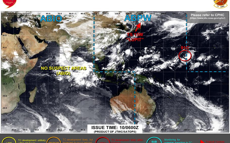
11:15 a.m. Wednesday, Aug. 4, Japan time: A tropical cyclone formation alert has been issued for tropical disturbance 97W Invest by the Joint Typhoon Warning Center. At 9 a.m., it was 161 miles south-southwest of Kadena Air Base, Okinawa, according to JTWC.
Current model track guidance and forecast ensembles indicate that it could affect the Tokyo area by the weekend and perhaps impact Saturday’s and Sunday’s events at the 32nd Summer Olympic Games in Tokyo.
Yokosuka Naval Base’s long-range forecast calls rain and thunderstorms into the weekend with southeasterly 29- to 40-mph sustained winds and 52-mph gusts early Sunday morning, shifting southeasterly later Sunday morning and diminishing as the day wears on.
More immediately, local forecasts for Okinawa call for high winds picking up Wednesday afternoon and continuing into Thursday.
Kadena’s 18th Wing Weather Flight continues to call for rain, showers, scattered thunderstorms and easterly winds, shifting to southerly as high as 23-mph sustained and 34-mph gusts into Thursday, increasing as the weekend approaches and with Tropical Storm Lupit in the area.
U.S. bases on Okinawa remain in seasonal Tropical Cyclone Condition of Readiness 4 for the moment. More to come, particularly if 97W develops into a tropical cyclone and we get an official forecast track from JTWC.
***
6:30 a.m. Wednesday, Aug. 4, Japan time: Checking out the tropical scoreboard, 13W has been upgraded to a tropical storm, 97W Invest remains just southwest of Okinawa, and Kadena Air Base’s 18th Wing Weather Flight and Japanese weather forecasts continue to call for blustery conditions and rain, heavy at times, over the next few days.
At 3 a.m., 13W was 98 miles south-southeast of Hong Kong, moving east at 6 mph with 40-mph sustained winds and 52-mph gusts, according to Joint Typhoon Warning Center. Hong Kong Observatory issued Standby Signal 1 at 4:20 a.m. Hong Kong Time, with 13W moving out of the area.
U.S. bases on Okinawa remain in seasonal Tropical Cyclone Condition of Readiness 4. The weather flight’s extended forecast continues to call for a 50- to 70-percent chance of showers and thunderstorms through the rest of the week, with southerly winds peaking at 31-mph sustained and 44- to 47-mph gusts on Saturday, shifting southwesterly into Sunday and diminishing.
Japanese weather forecast calls for high winds, gale-force at times, picking up out of the southeast and shifting southwest through Wednesday into Thursday, with rain, heavy at times. Japan Meteorological Agency has posted a thunderstorm and high-wave advisory; check here for the latest as the day wears on.
If 13W remains on present heading, it faces an uphill struggle, as the forecast track shows it skimming China’s southeast coast, heading inland for a bit, then resuming its march over water as a tropical depression, passing 244 miles west-northwest of Kadena at 11 p.m. Sunday.
Long-term, whether 13W or 97W or both have an impact on Japan’s main islands remains to be seen. More to come this evening.
***
9 p.m. Tuesday, Aug. 3, Japan time: Tropical Depression 13W remains far from Okinawa, 1,081 miles west-southwest as of 3 p.m., moving east-northeast at 5 mph, with 35-mph sustained winds and 46-mph gusts at center.
Strong Wind Signal 3 has been raised by the Hong Kong Observatory, and should remain in effect until morning.
Extended forecast from Kadena Air Base’s 18th Wing Weather Flight remains the same as earlier, peak 35-mph sustained winds and 48-mph gusts forecast for Wednesday, with 40- to 60-percent chance of rain and thunderstorms continuing through the week.
U.S. bases on Okinawa remain in seasonal TCCOR 4.
If 13W stays on forecast track, it's due to skim China's southeast coast and pass 340 miles west-northwest of Kadena at 9 a.m. Sunday as a tropical depression.
97W Invest does remain west-northwest of Okinawa and could impact the weather as well.
Joint Typhoon Warning Center has issued its final warning on Tropical Depression 12W, which remains well away from any major land mass.
***
8 a.m. Tuesday, Aug. 3, Japan time: Not just one, but two tropical depressions are out there now, 12W and 13W. Joint Typhoon Warning Center’s forecast tracks indicate neither to be an imminent threat to any U.S. facilities in Japan, though Okinawa can expect some blustery, rainy weather as this week wears on.
At 3 a.m., JTWC 12W was 1,064 miles southeast of Yokosuka Naval Base, moving north-northwest at 21 mph with 35-mph sustained winds and 46-mph gusts. 13W was 113 miles southwest of Hong Kong, moving east at 14 mph with 29-mph sustained winds and 40-mph gusts; Standby Signal 1 is in effect for Hong Kong.
12W remains forecast to die out early Friday morning about 330 miles north-northeast of Iwo Jima. 13W is forecast to peak at 52-mph sustained winds and 63-mph gusts as it skims China’s southeast coast, splits the difference between China and Taiwan and passes 371 miles west of Kadena Air Base early Sunday morning.
But with 12W and 97W Invest in the vicinity, the weather picture for Okinawa is fairly rough, according to Kadena’s 18th Wing Weather Flight. U.S. bases on Okinawa remain in seasonal Tropical Cyclone Condition of Readiness 4.
Kadena’s extended weather forecast calls for a 40- to 60-percent chance of rain and scattered thunderstorms the rest of the week, with southerly 32-mph sustained winds and gusts between 45 and 48 mph on Wednesday afternoon, continuing as the week wears on.
A weather picture that bears considerable watching. Storm Tracker has the watch.
***
11:30 p.m. Monday, Aug. 2, Japan time: Not only is Tropical Depression 12W out there well southeast of Japan, but several other disturbances are lurking, two of which, 97W Invest and 90W Invest, could impact southwestern Japan in the coming days.
Joint Typhoon Warning Center issued a tropical cyclone formation alert on 90W, which has crossed the Leizhou Peninsula in southeastern China and is heading east-northeast through the South China Sea. 97W is labeled a “medium” area for development in the next 24 hours by JTWC; it sits about 170 miles west-northwest of Kadena Air Base, Okinawa, and is sitting quasi-stationary as it develops.
At lot to keep eyes on. More just after sunrise.
***
6:30 p.m. Monday, Aug. 2, Japan time: Tropical Depression 12W spawned Monday afternoon well southeast of Japan. According to the Joint Typhoon Warning Center’s initial forecast track, it appears as though it should remain a tropical depression and die out within a couple of days well away from land.
At 3 p.m., 12W was 1,219 miles southeast of Yokosuka Naval Base, tracking north-northwest at 18 mph with 29-mph sustained winds and 40-mph gusts. If it remains on present heading, JTWC projects it to curve northwest, then west, weakening the whole while before dissipating about 420 miles northeast of Iwo Jima at mid-afternoon Wednesday.
