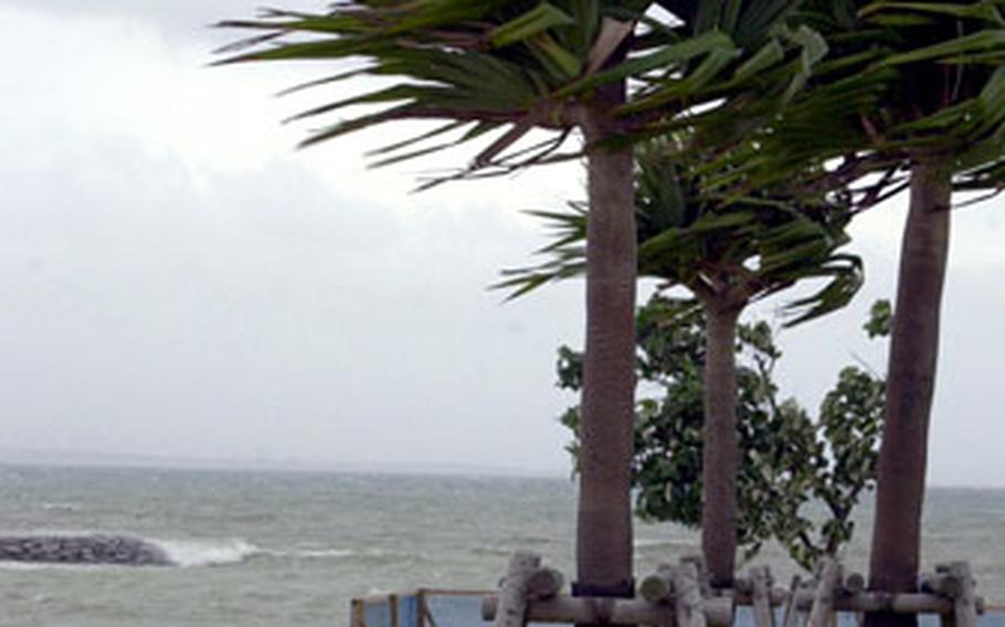
Trees bend in the wind and surf crashes against the shore at Uken Beach near Camp Courtney, Okinawa, on Saturday as Typhoon Ewiniar rolls in. (Cindy Fisher / Stars and Stripes)
CAMP FOSTER, Okinawa — Typhoon Ewiniar passed 115 miles west of Okinawa overnight Saturday, raking the island with 66 mph winds and dumping more than 1¼ inches of rain into Sunday afternoon, then churned north toward the Yellow Sea between China and the Korean peninsula.
Okinawa entered Tropical Cyclone Condition of Readiness 1E (emergency) early Sunday morning, with all U.S. bases on the island in lockdown for just under nine hours.
And as Ewiniar, the fourth storm of the northwest Pacific’s tropical cyclone season, sped northward, the fifth continued growing in size in strength well to the southeast Sunday.
“It’s still in the organizing phase, it hasn’t consolidated yet,” said Air Force Capt. Jason Blackerby, a typhoon duty officer at the Joint Typhoon Warning Center in Hawaii. “But it’s still dangerous enough to be warned about.”
Preliminary tracks have the storm moving west-northwest for about 72 hours, heading toward Luzon island in the Philippines and south of Okinawa, Blackerby said. The JTWC’s midnight Sunday update showed the storm then tracking farther west into Taiwan by Friday.
But even if the storm’s eye remains to the south, “Okinawa could get significant winds from the northern periphery of the wind field,” he said.
“It’s still too soon to say, definitely” what the storm, dubbed Bilis, might do, said Capt. Colin Reece, 18th Weather Flight commander at Okinawa’s Kadena Air Base. “But we’ll keep an eye on it, by all means.”
Bilis is a Filipino word that means speed or fleetness in Tagalog. At midnight Sunday, Bilis was 995 miles southeast of Okinawa, heading west-northwest at 15 mph, packing sustained winds of 40 mph and gusts of up to 52 mph at its center. The JTWC’s forecast track has the storm creeping within 352 miles southeast of Okinawa at 10 p.m. Thursday, packing sustained winds of 69 mph and gusts of up to 86 mph.
Meanwhile, Ewiniar picked up directional speed but began to rapidly lose its punch as it chugged north toward the Yellow Sea. The JTWC forecasts Ewiniar to be downgraded to a tropical storm sometime between 9 p.m. Sunday and 9 a.m. Monday.
At midnight Sunday, Ewiniar was 288 miles southwest of Sasebo Naval Base in southwestern Japan, moving almost due north at 17 mph, packing sustained winds of 69 mph and gusts of up to 86 mph.
It’s expected to skirt South Korea’s west coast, edging 23 miles west of Kunsan Air Base at 5 p.m. Monday, 28 miles west of Osan Air Base at 9 p.m. and 22 miles west of Yongsan Garrison at 10 p.m., packing sustained winds of 52 mph and gusts up to 63 mph.
At midday Sunday, U.S. Forces Korea remained in TCCOR 4, which had been issued Friday. “Nothing’s changed” at Osan and Kunsan, said 51st Fighter Wing spokesman Tech Sgt. Michael O’Connor by telephone Sunday. The 51st and Kunsan’s 8th Fighter Wing planned to look again at Ewiniar’s track Monday morning and would “act accordingly” if the storm became a threat.
Preliminary reports from military officials on Okinawa indicated neither serious damage nor injuries on U.S. bases. Japanese media reported that two 13-year-olds were slightly injured when a steel handball goal fell on them at a junior high school in Urasoe.
