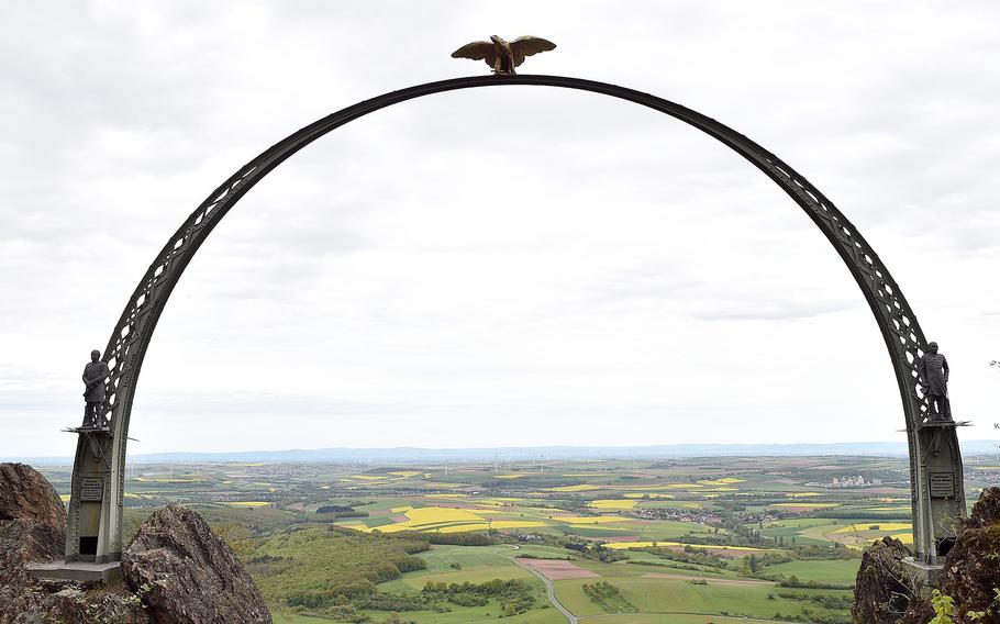
The Adlerbogen is an iconic spot on the Donnersberg near Dannenfels, Germany. The monument honors Field Marshal Helmuth von Moltke and was built in 1880. Allied Forces destroyed the eagle on the top in 1945, and it was restored in 1981. In 2016, the entire structure was restored. (Matt Wagner/Stars and Stripes)
Anyone driving north of Kaiserslautern has seen the Donnersberg, or “Thunder Mountain,” even though they might not realize it.
Signage on the A63 autobahn doesn’t allude much to the mountain, which looks more like a huge hill and is easily distinguishable thanks to its signature TV tower. Reaching an elevation of 2,254 feet above sea level, it’s the highest point in the Pfalz.
Living just a handful of miles away, I see the mountain every day and almost feel as if it has been taunting me to explore.
Still, it took me 17 months to build up the courage and the stamina to hike up the mountain, which often is enveloped in clouds during inclement weather and surrounded by a haze during the warmest days.
A buddy and I chose a mid-spring Sunday when, despite a slight chance of light rain, the views wouldn’t be affected. We started our trek from a parking area just south of the town of Dannenfels, nestled on the east face of the Donnersberg.
Two things immediately stuck out. The first was how well-marked most trails are. The second was I didn’t prepare enough for the incline. But still, I carried on.
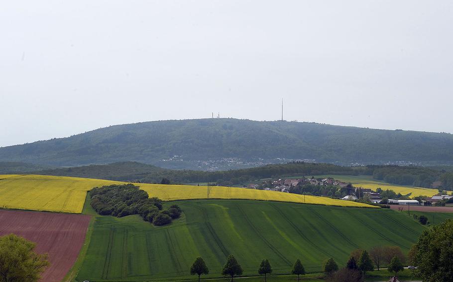
This photo shows the Donnersberg from a distance east of the mountain on a bike path north of Marnheim, Germany. The highest point in the Pfalz region, the Donnersberg can be seen west of autobahn A63 heading north of Kaiserslautern. (Matt Wagner/Stars and Stripes)
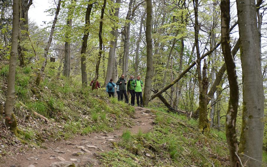
Hikers traverse a narrow path on the Donnersberg near Dannenfels, Germany, on April 28, 2024. The mountain is a popular recreation destination in the Pfalz. (Matt Wagner/Stars and Stripes)
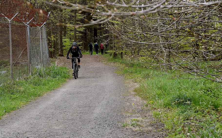
A cyclist rides toward the top of the Donnersberg near Dannenfels, Germany, on April 28, 2024. Gravel is among the trail surfaces hikers and cyclists traverse on the Donnersberg. (Matt Wagner/Stars and Stripes)
And I’m glad I did. The three-hour-long, 5-plus-mile adventure was a breath of fresh air, and when we got to the top, the views were worth it.
On the east side sits the Adlerbogen, a monument built in 1880 commemorating Field Marshal Helmuth von Moltke, celebrated for his prowess in the Prussian army during the Austro-Prussian and Franco-Prussian wars.
From there, you can see miles and miles, which on that day included so many golden fields of rapeseed plants, as well as my village, which looked the size of a postage stamp.
The Adlerbogen also has an American connection. In 1945, before the end of World War II, U.S. troops shot down the eagle that sits atop the structure. A restoration in 1981 returned the bird to its perch.
In addition, the Donnersberg once hosted the largest U.S. radio station in Western Europe. The station was a primary hub for U.S. military communications from after World War II until its close in 2011.
I may have walked by the old station on the half-mile stretch between the Ludwigsturm and the Königstuhl, or “King’s chair,” a rock formation. Composed of rhyolite, a silica-rich volcanic rock, it is on the west side of the mountain and marks the summit.
There, many hikers took a break, sitting down and staring into the distance or reenergizing with a snack.
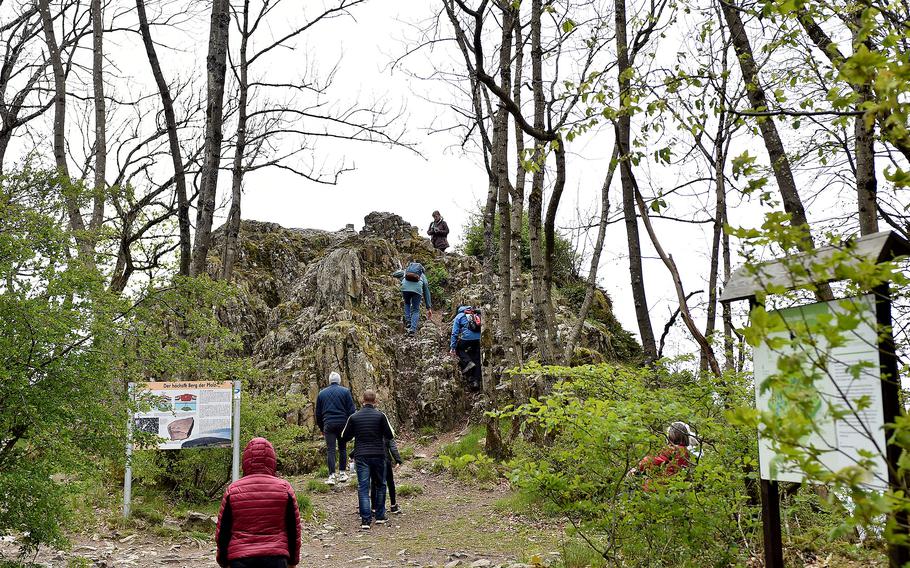
Hikers climb up the Königsstuhl on April 28, 2024. Composed of rhyolite, a silicia-rich volcanic rock, it sits at an elevation of 2,254 feet, making it the highest point in the Pfalz region of Germany. (Matt Wagner/Stars and Stripes)
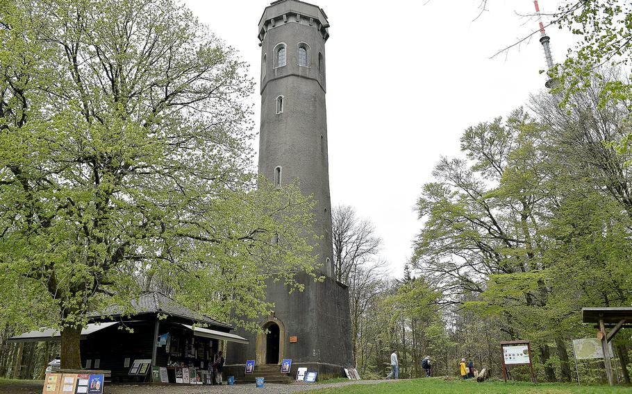
The Ludwigsturm, or Ludwig's Tower, rises from the Donnersberg near Dannenfels, Germany. The structure stands 88.5 feet tall and has a kiosk next to it that sells refreshments for hikers. (Matt Wagner/Stars and Stripes)
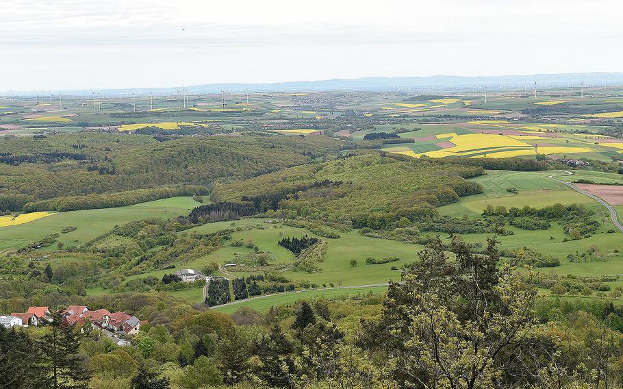
This view from the Donnersberg near Dannenfels, Germany, shows the landscape to the east. Donnersberg means "Thunder Mountain." (Matt Wagner/Stars and Stripes)
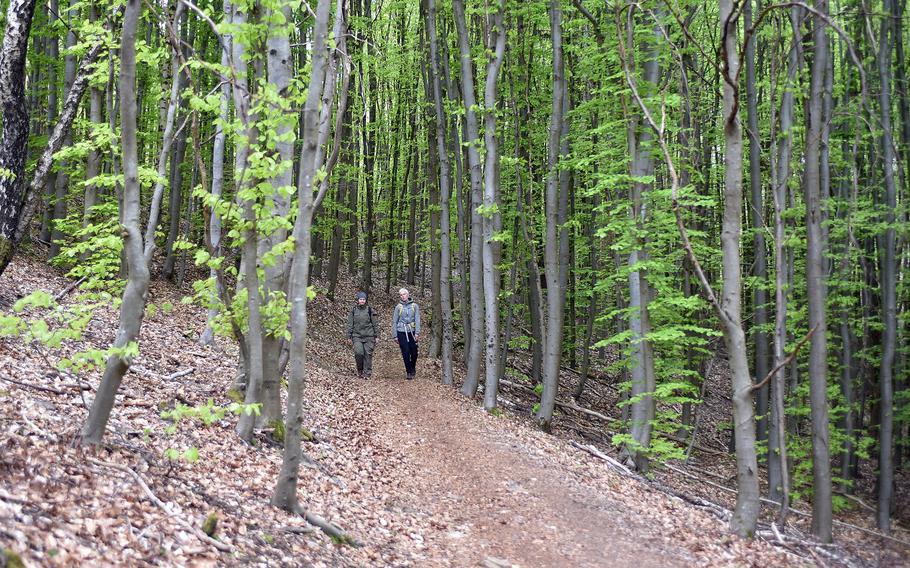
A pair of hikers walk along a path on the Donnersberg near Dannenfels, Germany, on April 28, 2024. The summit of the mountain is the highest point in the Pfalz region. (Matt Wagner/Stars and Stripes)
Still, the best part was getting “lost” in the woods. The Donnersberg has 5,830.5 acres of land, and people can traverse the numerous paths.
The terrain of the paths varies, with some being more wild than others. Most were well-kept, be it gravel, a natural footpath or even paved road. We also encountered mountain biking paths, which were narrower and muddier than the rest.
Climbing the Königstuhl can be dicey, as I discovered while watching an older man struggle coming down, even with the aid of a pair of trekking poles.
I suggest wearing the right footwear and not just any pair of sneakers. Boots are the best option, but my trail runners did the trick.
My friend and I also came across paths not marked on maps, “shortcuts” as a person from the area described to us, as we were lost trying to get back to the car at the end. She gave us directions, going well above and beyond the usual German “hallo” to passers-by.
There is homage to ancient history on the mountain as well. The Celtic Sculpture Path goes for over 4 miles and features various replicas of Celtic structures, harkening back to a Donnersberg settlement from more than 2,000 years ago.
Overall, it’s a great place to spend a couple of hours in nature. And if you aren’t into hiking uphill, no worries; you can start near the top by driving to a parking lot near the Ludwigsturm and still get in some miles on a much flatter landscape.
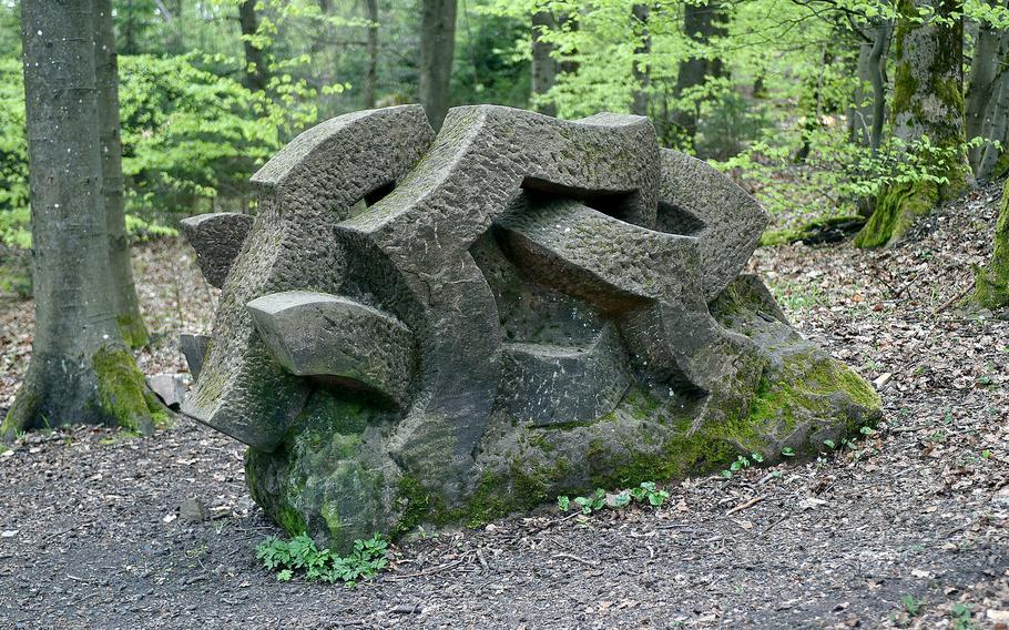
This sculpture, titled "Wild Boar," was made by Klaus Hunsicker and sits on the Celtic Sculpture Path on the Donnersberg near Dannenfels, Germany. The path stretches 4.35 miles from Steinbach to the Donnersberg, consists of 13 pieces of art and pays homage to the Celtic settlement on the mountain thousands of years ago. (Matt Wagner/Stars and Stripes)
Donnersberg
Where: Dannenfels, Germany
Directions: From Kaiserslautern, take the A63 north to the Göllheim exit, take the L397 west into Dannenfels. To drive to the top, continue to Mittelstrasse and Bastenhausenstrasse before turning into L394. After a mile, take the third exit on the roundabout onto the K82. Parking is available after driving 1.5 miles.
Information: www.donnersberg-touristik.de
.jpg/alternates/SQUARE_100/Wagner%20headshot%20002.jpg)