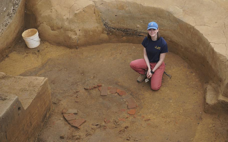
Natalie Reed is one of the Jamestown archaeologists who helped uncover the first bricks of a well in a previously unexplored area on Jamestown Island. (Dominic Catacora/TNS)
(Tribune News Service) — The historical image of James Fort that is used as a logo for the Jamestown Rediscovery Project and Historic Jamestowne may be leading archaeologists to John Smith’s long-lost town.
The hand-drawn James Fort derives from an intriguing 1608 map that archeologists call the Zuñiga Map. The map is named after Pedro De Zuñiga, the Spanish ambassador who had sent a copy of John Smith’s original 1608 map of Virginia from England to Spain during that same year.
Now, a flag on the map has led to the excavation of a new site that holds promises of additional discoveries. But archaeologists remain in a race with time and the tides to uncover what John Smith wrote in his last writings regarding the layout of the town.
“We’re excited about this emerging landscape,” said Dave Givens, Jamestown’s director of archaeology.
Zuñiga was a courtesan when King James I of England was on the throne in 1603. According to the Jamestown archaeology team, the king wanted to open up lines of communication with the Spanish. However, knowing that the English were getting more and more involved with colonialism at the time, having already claimed part of North America, Zuñiga stole a copy of John Smith’s map and sent it to King Phillip III.
There’s a letter from Zuñiga to Philip III in the British Library, dating back to Sept. 10, 1608, which states, according to Jamestown Rediscovery:
“I have thought proper to send Y.M. a plan of Virginia and another of the Fort which the English have erected there, together with a report given me by a person who has been there. Still, I am trying to learn more and I shall report about it.”
The Zuñiga map is one of the only maps that shows the exact location of James Fort. The map also includes the surrounding landscape and waterways in addition to the triangular fort and the church inside. However, there is a peculiar feature that looks like a flag extending from the north bulwark.
This flag feature of the map was added right before it left for England in June 1608, and it was received by the Spanish sometime later that year. For years, archaeologists thought it was just a flag. However, former Jamestown curator Bly Straube proposed that the flag could indicate an enclosure or even a garden.
In 2019, Jamestown Rediscovery used ground penetrating radar to take a closer look across the north field where the flag is positioned on the map. The GPR survey discovered a large ditch in the north field around where the flag feature should be.
Flooding from the Pitch & Tar Swamp of the island has led to a greater priority in investigating the north field. Givens, and other head archaeologists, like senior staff archaeologist Mary Anna Hartley, say that environmental conditions threaten the archaeological materials which may lie beneath the surface of these parts of the island.
Curious about the ditch, researchers and archaeologists began to excavate it in 2022. Last summer, Jamestown archaeologists worked alongside the University of Virginia Field School and participants from Jamestown Rediscovery Kids Camp to help dig out a previously discovered Confederate moat from 1861. The moat was cutting into the ditch, which they believe dates to 1608.
Then, they found an old well.
The brick-lined well, believed to date back to 1617, is north of what was once Fort Pocahontas. Fort Pocahontas was a Civil War-era Confederate fort that was built on top of James Fort shortly after Confederate troops arrived at the island in 1861. The discovery reminded the team of the 1617 “Smithfield Well” excavated in 2002 outside James Fort to the north of the western palisade.
These wells come from a period known as the Fort Period (ca. 1607-1624). Artifacts like a breastplate, a sword blade, and a collection of plate armor artifacts were uncovered during that excavation. The archaeologists at Jamestown are hoping to uncover similar artifacts when they excavate the remainder of the well.
Archaeologists revealed the builder’s trench of the well and the full surface of the brick structure in January and will excavate the well this fall.
“It’s just the beginning,” Givens said. “We found the core, the first three years are very well defined, and we know nothing, essentially, about that transitional time, say, up to mid-century. The 1630s and on, that’s been well documented, but nothing in the 1610s. It’s very gray.”
The evolving landscape and environmental conditions of the island have forced the team of archaeologists to rethink how they prioritize research projects as they move forward in the years to come. Advancements in ground penetrating radar allow for a greater grasp of the island’s features, which may hold remnants of the settlement’s earliest history.
John Smith wrote of more than 50 houses at Jamestown in 1608, and archaeologists have yet to uncover any of these houses.
Increased inundation, land subsidence, extreme storm events, a rising aquifer and aging infrastructure are all contributing to challenges on the island. Last year, the historic site was placed on the National Trust for Historic Preservation’s 2022 list of America’s most endangered places.
“Sea level rise is complicated,” Givens said. “We started thinking about it, and asked, ‘Why is this happening? Why are we seeing inundated areas that we never saw before within our careers?’ and it turns out there are a lot of reasons.”
Givens says that sea level rise has been examined by many different organizations throughout Hampton Roads, including nearby military bases.
Much like the Outer Banks, Jamestown Island falls on a saltwater aquifer. When the saltwater rises, it leads to dead tree roots that can potentially cause trees to topple over the island’s many archaeological sites.
The rising saltwater aquifer also causes seawater to mix in with the water in the swamp area of the island, potentially damaging some of Jamestown’s earliest material yet to be uncovered.
©2023 Daily Press.
Visit dailypress.com.
Distributed by Tribune Content Agency, LLC.