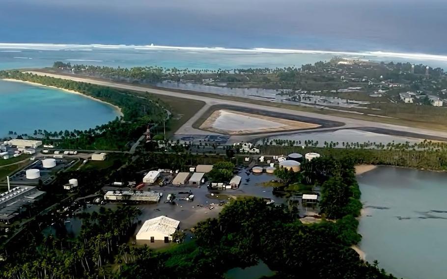
A screenshot of an aerial video taken over Roi-Namur, Marshall Islands, shows flood water inundating the island on Jan. 21, 2024, the day after massive waves. (U.S. Army)
Army officials are assessing flood damage to a Marshall Islands installation pounded by huge waves on Saturday that led to the evacuation of roughly half the 120 personnel who live there.
About 60 people were evacuated from Roi-Namur on a catamaran Sunday and brought to Kwajalein, about 50 miles south, according to an Army news release Tuesday.
No one was seriously injured during the flooding, the Army said. Some of the island remains under water.
Roi-Namur and Kwajalein are home to the Ronald Reagan Ballistic Missile Defense Test Site. Access to either island is limited to Department of Defense personnel and contractors, as well as their family members.
Flooding from the waves damaged much of the housing used for unaccompanied personnel, the Army said.
Moderately to severely damaged were the dining facility, Outrigger Bar and Grill, the chapel and the Tradewinds Theater, the Army said.
“The automotive complex remains under water,” the Army said.
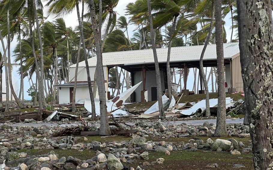
The Roi-Namur church steeple rests on the coral-strewn grounds after being damaged by high waves on Roi-Namur, Marshall Islands, on Jan. 20, 2024. (U.S. Army)
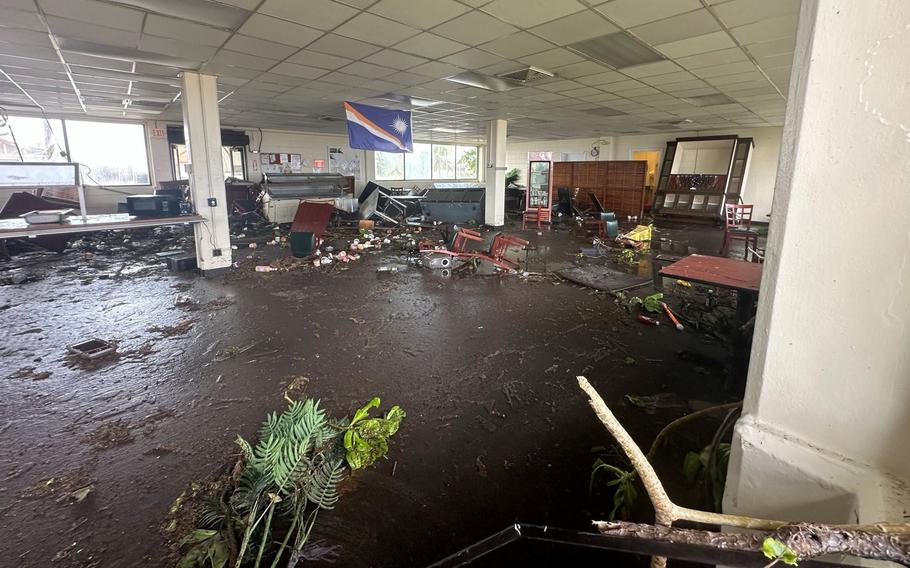
The Cafe Roi dining facility on Roi-Namur, Marshall Islands, was heavily flooded following massive waves on Jan. 20, 2024. (U.S. Army)
One viral video of the flooding, taken from inside a building, shows a massive wave knocking two people off their feet and filling a room. The wave then crashed down two double doors and flowed into an adjoining room.
“The last 36 hours have been incredibly challenging for us,” Col. Drew Morgan, commander of U.S. Army Garrison-Kwajalein, said in a Facebook video posted Monday.
“This is going to go down in Kwaj’s history books as one of its most challenging times ever in its 80-year history. We will get through this, and we are settling in for a marathon of recovery ahead. It may last months or even years.”
About 60 personnel remained on the island to begin assessing the damage and restoring utilities under what the garrison has dubbed Operation Roi Recovery, the Army said.
“Clearing the runway on Roi-Namur and assessing its safety is our top priority now that we have evacuated personnel not required for the initial response efforts,” Morgan said in the news release.
“Once the runway is open, we can move people and equipment back and forth to start the recovery process,” he said.
Some Roi-Namur workers live on Kwajalein and commute via plane daily or weekly.
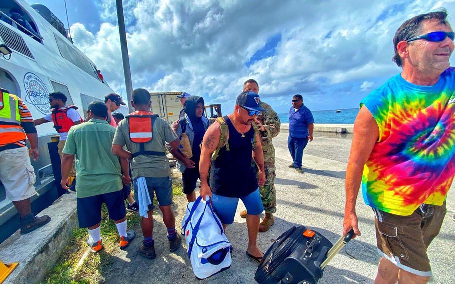
Roi-Namur residents arrive at Kwajalein on Jan. 21, 2024, in the wake of catastrophic flooding from large waves the day before. (U.S. Army)
Kwajalein lies about 1,600 miles from Guam and more than 2,000 miles from Hawaii or Japan. The U.S. and the Marshall Islands signed a Compact of Free Association in 1983 that gives America full authority and responsibility for the sovereign nation’s defense.
Japan militarized Kwajalein and Roi-Namur in the 1930s, building the foundations of the air strips and ports that are still used. U.S. forces took the atoll in February 1944 after Navy artillery pummeled both islands; Marines stormed Roi-Namur and soldiers took Kwajalein.
Roi-Namur is home to massive radars used to track U.S. test missiles for the DOD.
Roi-Namur lies about six feet above sea level and is at growing risk of damage from sea level rise, according to a 2017 report by the U.S. Geological Survey for the DOD.
Wave-driven flooding would be expected to significantly impact Roi-Namur with a roughly 15-inch rise in sea level over the level in 2017, the study found.
“At this point, without active management measures, the annual amount of seawater flooded onto the island during storms will be of sufficient volume to make the groundwater non-potable year-round,” the report states.
Under one model of projected sea-level rise, the island would reach that “tipping point” between 2030 and 2040.