U.S.
After record rains, California storm shifts east; so what’s next?
By
The Washington Post February 6, 2024
Matthew Cappucci and Ian Livingston
The Washington Post February 6, 2024
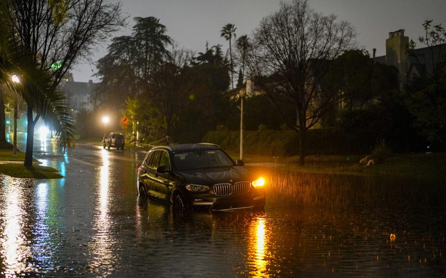
An abandoned car sits in floodwaters during an atmospheric river storm in Los Angeles on Feb. 5, 2024. (Kyle Grillot for The Washington Post)
After record-shattering rains poured over swaths of California, the potent atmospheric river continues to sweep through the state and move eastward. Rainfall totals as high as 10 inches or more brought widespread severe flash flooding and triggered more than 300 landslides within just the greater Los Angeles area.
As of early Tuesday, more than 150,000 California customers were without power, and at least three people have been confirmed killed after impacts extended well beyond where rain was most concentrated. The remainder of the Golden State still faced significant to copious rains, locally damaging winds and, in the mountains, at least 5 feet of snow.
Flood watches have been dropped in Northern and central California, where rains have at last wound down. Southern California, meanwhile, is facing another inch or so, with locally greater amounts where thunderstorms pivot ashore Tuesday afternoon. There’s even a remote chance of small hail or an isolated funnel cloud with any thunderstorms that form.
The episode even reached the threshold of a 1,000-year rain event at a gauge at the University of California at Los Angeles, where 12.46 inches fell in 24 hours. That means that so much rainfall had only a 0.1 percent chance of happening in any given year.
According to statistical data maintained by the National Weather Service, it would only take 11.5 inches to be in 1,000-year territory. Downtown Los Angeles, meanwhile, saw their wettest day in 19 years and logged two months’ worth of rain in two days. Its two-day total of 7.03 inches was a record for February.
In the higher elevations of Southern California, snow continues. The San Bernardino and Riverside County mountains could see another 4 to 8 inches of snow above 6,000 feet, with up to 2-plus feet above 8,000 feet elevation. Mountain snows continue in the Sierra Nevada, too, and will expand into the Great Basin of Nevada, as well as the Four Corners region. Winter storm warnings plaster the Southwest.
One small piece of good news is that destructive winds have finally subsided and no longer look to pose a concern. Gusts reached 70 to 80 mph in the Bay Area and topped 100 mph in the mountains. At Palisades ski resort near Lake Tahoe, a mountaintop station reported a gust to 148 mph.
What’s next for the storm?
On Monday night into Tuesday morning, there was some restructuring with the storm.
Previously, a low-pressure center had been located offshore of Eureka in Northern California. That counterclockwise-spinning low dragged the atmospheric river to its east into Southern California. A second batch of downpours had formed beneath the core of that low pressure.
But in the past 12 to 18 hours, that main low has dissipated — meaning the showers beneath it have largely vanished, causing rainfall to ease in Northern California. Simultaneously, however, a new low is forming over Southern California within the broader batch of rain and will shift northeast into Nevada.
That caused an expansion of the rainfall overnight in Southern California, but the new low will drag the atmospheric river eastward and out of the area. By Tuesday evening, it should be aimed mainly at Nevada.
That means two things:
The coverage of rainfall will decrease for Las Vegas and San Diego by the afternoon hours.
The intensity of precipitation will become more variable; while the main slug of rain will push east, a few thunderstorms will pinwheel into Southern California into Wednesday. Much of the time will be dry, but a few brief bursts of heavy rainfall, with rates of 0.5 to 1 inch per hour, are possible. That could trigger additional flooding until the rain finally stops entirely later Wednesday.
The eastward push of the atmospheric river will bring heavy rains to Arizona. Phoenix is under a flood watch and could see an inch of rain, give or take. The heaviest will fall from Tuesday afternoon to Wednesday morning local time.
In the higher elevations, it’s all snow. That’s true across the Four Corners, where a plowable mountain snow is expected. Winter storm warnings cover much of the higher terrain of Arizona, Nevada, Colorado and Utah.
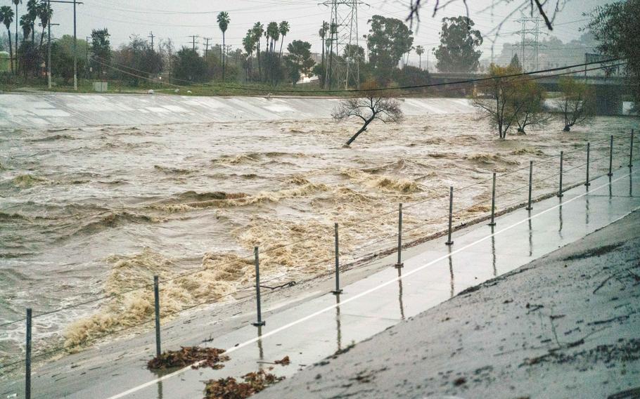
Submerged trees in the flooded Los Angeles River during an atmospheric river storm in Los Angeles on Feb. 5, 2024. (Kyle Grillot for The Washington Post)
Summary of the storm’s historic totals
Tons of rain
Rainfall totals of 2 to 6 inches are common near sea level from north of the San Francisco Bay Area to near San Diego. Nearer coastal mountain ranges, readings up to 6 to 10 inches are widespread.
The higher-end readings impacted parts of the Los Angeles metropolitan area as well as near and north of Santa Monica, through the San Gabriels and into the San Bernardino Mountains.
Los Angeles picked up 7.03 inches from Sunday and Monday alone, which is the third-wettest two-day stretch on record there since 1877. It was the wettest two days since Jan. 25-26, 1956, when 7.44 inches fell.
Dozens of landslides and more than 150 flood reports have been catalogued by the Weather Service as of early Tuesday.
Some of the most impressive known totals from Southern California:
9.68 inches near Ojai
9.5 inches in Porter Ranch
8.75 inches at Lake Arrowhead
7.78 inches in Van Nuys
7.34 inches in downtown Los Angeles
The weather station at UCLA also recorded over 13 inches over recent days. Two stations near each other in the Santa Monica Mountains similarly reported 15.24 and 16.16 inches over the period. The accuracy of these measurements is uncertain, but the totals are not implausible.
Other zones of extreme precipitation occurred in the mountains north of San Francisco, around Mount Shasta and then from north to south across parts of the Sierra Nevada, including the following rainfall totals:
8.53 inches northeast of Santa Cruz
6.51 inches northwest of Santa Rosa
4.76 inches in Napa
4.40 inches near Soda Springs
2.06 in Bishop
2.02 inches in downtown San Francisco
Raging winds
Strong to damaging winds touched most of California from Sunday through Monday, leading to more than a million cumulative outages. Nearly 350 wind damage or severe wind gust reports have been logged by various sources connected to the Weather Service, such as:
148 mph — Palisades-Siberia
125 mph — Mammoth Mountain
102 mph — Lagunitas Forest
102 mph — Pablo Point
98 mph— Santa Clarita
94 mph — Grapevine
88 mph — Point Reyes
87 mph — Flea Mountain
78 mph — San Fernando
77 mph — San Francisco
Mountain snow
The Sierra Nevada cashed in on heavy wet snow, and it was needed considering the water contained in the state’s snowpack was just half the normal amount before the storm.
Totals of 2 to 5 feet were observed in the high elevations of central and Northern California. One to 2 feet fell in the mountain peaks of Southern California, and snow was continuing Tuesday.
As of Monday, the state’s snow water content had grown to 72 percent of normal to date, a number that should keep growing Tuesday.
Another foot or two could still accumulate in California’s mountains through Thursday, especially from the southern Sierra to the mountains north and east.