U.S.
Hurricane Hilary barreling toward California, 'life-threatening' flooding possible Sunday
By
The Washington Post August 19, 2023
Diana Leonard, Ian Livingston, Jason Samenow
The Washington Post August 19, 2023
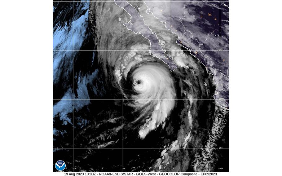
Hurricane Hilary is seen off the Pacific coast of Baja California, Mexico, on Aug. 19, 2023. (National Weather Service/Facebook)
SAN DIEGO — Hurricane Hilary is barreling toward Southern California, and the region is bracing for the potentially dangerous flooding and hazardous winds. While the monster storm will weaken during its northward march, it is nonetheless expected to bring extreme and wide-reaching impacts to California, the Desert Southwest and Baja California in Mexico.
A tropical storm warning is in effect for coastal and inland Southern California, including San Diego and Los Angeles — the first such warning issued for this location by the National Hurricane Center. Baja California is expected to see hurricane conditions by Saturday evening.
Forecasters are not mincing words when it comes to the danger the storm poses, particularly for flooding. And authorities are urging preparation.
"Catastrophic and life-threatening flooding is likely over Baja California and the Southwestern U.S. through Monday," the National Hurricane Center warned Saturday.
Rainfall was already underway in the region in advance of Hilary. Flash flood warnings were issued Friday night in the border region of California and Arizona, as well as south of Las Vegas. Several inches of rain fell in some locations, leading to road closures due to high water near Needles and Lake Havasu. Additional warnings were in effect Saturday morning east of San Diego and in the afternoon east of Bakersfield.
The current rainfall is not directly due to Hilary, but influenced by it through something called a predecessor rain event. They form well to the north of a tropical system, often in an area where the storm will later track.
Computer model projections late Saturday afternoon projected the heaviest rain to fall in a zone from areas just east of San Diego and Los Angeles through Palm Springs and then extending northeast through Death Valley and southwest and west central Nevada. While downpours are probable in Las Vegas, the heaviest rain may fall to its west and northwest.
The rain is expected to come in two primary waves, the first Saturday night into Sunday morning and the second Sunday afternoon into Sunday night when the core of Hilary comes through. This second wave will also bring the most intense rainfall and the threat of damaging winds. By Monday morning, what's left of the storm should be sweeping through northern Nevada.
At the storm's peak during the second half of Sunday, rainfall rates could reach at least 1 to 2 inches per hour — especially in the mountains — and the high winds could topple trees and trigger power outages. Los Angeles and San Diego are both expected to see about 2 to 3 inches of rain. The two cities average hardly a trace during August, typically the driest time of year. The downpours could lead to flooding, especially in areas of poor drainage and near streams.
Substantially higher amounts — 4 to 7 inches or more — are probable in the mountains to the east of Los Angeles and San Diego.
The National Weather Service said Saturday the areas of most concern for "extremely dangerous and damaging" road and creek flooding lie in the Los Angeles County mountains and Antelope Valley.
In a briefing Friday, UCLA climate scientist Daniel Swain called the storm "a remarkable, rare, historic event for California" that could produce severe and even disastrous impacts for the state's southeastern desert interior. Both desert and mountainous areas of southwest and central Nevada should brace for serious effects as well.
"The heavy rainfall combined with high winds expected at elevation could lead to mudslides and landslides, which would be exacerbated where trees uproot within saturating soils. Debris flows and rock slides are a given considering the volume of rainfall expected," the Weather Service wrote in a discussion about the heavy rain potential. "The overall combination of effects could block and undermine roads, particularly sensitive areas such as sections of U.S. 50 in NV [Nevada]. Towns could get cut off."
The discussion called the rainfall potential "extreme," noting moisture levels will approach or exceed all-time levels and that precipitation amounts will probably surpass 1-in-100 year levels.
"Some locations within this arid region are slated to get 1-2 years worth of rain in one day," the discussion said.
David Roth, a veteran precipitation forecaster with the Weather Service who wrote the discussion, likened Hilary to the "Western equivalent of a Harvey or Florence" - hurricanes that produced historically severe rainfall events in Texas and North Carolina — in a thread on Twitter.
Where and when Hilary will hit the region
Hilary has started notably weakening, now a Category 2 with sustained winds of 110 mph. Decay of tropical characteristics will accelerate as the storm travels over colder water to its north and is increasingly affected by disruptive wind shear.
Although Hilary is forecast to make landfall about 150 miles south of the U.S.-Mexico border as a tropical storm on Sunday, strong winds and flooding rains will arrive well ahead of, and extend far from, the storm's center.
The storm has also recently begun to speed up, and forecasts have nudged the projected path eastward a bit. These factors should combine to bring the worst into southern California by Sunday morning, then lasting through the day. The center is expected to rapidly cross into California and race away northward Sunday afternoon.
"Preparations for the impacts of flooding from rainfall should be completed as soon as possible, as heavy rain will increase beginning Saturday," the National Weather Service's Weather Prediction Center said.
The amount of rain, and potential for flooding
An extremely rare Level 4 of 4 "high risk" notice for flash flooding is in place for the Southern California mountains and deserts for Sunday into Monday, including Death Valley.
"That should set off some alarm bells," Swain said of the early warnings by the Weather Prediction Center. "Unfortunately, [high risks] almost always turn out to be very high impact events."
Isolated amounts exceeding 10 inches of rain could fall in some parts of Southern California, with strongest bands likely to douse the eastern slopes of Southern California mountain ranges. But dangerous flooding could happen anywhere, and flood watches blanket a wide swath of the Western United States, from California and Arizona to eastern Oregon and central Idaho.
Several factors are coming together to intensify Hilary's rainfall.
There will be a near-record to record-breaking amount of available water in the atmosphere.
"About as much moisture in the air as this part of the world has seen," said Paul Iñiguez, a meteorologist at the Center for Western Weather and Water Extremes at the Scripps Institution of Oceanography at the University of California at San Diego.
The region's mountainous terrain will act to wring that moisture out of the air as it is forced upward. A low-pressure center along the California coast will draw Hilary's moisture rapidly north, and provide upper-level support for intense rain, according to Iñiguez.
The storm will also combine with monsoon moisture over some areas, with embedded thunderstorms intensifying the rain even further.
"It's going to be a pretty long corridor of heavy rain potential - that's why you see those flood watches extending all the way up into central Nevada," he said.
Death Valley, Calif., could see more than twice its annual rainfall in three days, or as much or more than it has since January 2021, with 6-8 inches falling in the surrounding mountains. A blend of weather models suggests record daily rainfall is a risk there. In 2022, an event forecast to be dwarfed by Hilary caused extensive flooding and damage in the valley.
And while the storm will quickly lose tropical characteristics as it heads northward after landfall, the rainfall footprint will continue traveling with its remnants. Several inches are likely in much of Nevada, and also in higher elevations of the northern Rockies.
"By day three, whatever falls will flow," said Jenn Varian, a meteorologist with the National Weather Service in Las Vegas. "We're talking several inches of rain completely flowing into Death Valley, which is incredibly vulnerable to flash flooding."
Officials have closed Death Valley National Park, as well as the Mojave National Preserve, where the York Fire burned nearly 100,000 acres last month. There is a "high confidence for major and historic flooding," according to the park website, as well as possible debris flows in the area.
Damaging winds also a concern
While the rain is the biggest threat, damaging wind will also be a major concern. Sustained winds of greater than 39 miles per hour are likely across portions of the tropical storm warning area in far southwest California, according to the National Weather Service in San Diego.
The strongest winds are likely to affect high elevations, as well as places immediately along the coastline.
Deserts and mountains may see wind gusts of over 70 miles per hour, but even the metropolitan areas closer to the coast could have 40 to 50 mph gusts.
"That will down power lines, that can down trees, that will move any loose objects that are not secure," Alex Tardy, warning coordination meteorologist for the National Weather Service in San Diego, said in a briefing on Friday.
California Gov. Gavin Newsom (D) on Saturday declared a state of emergency ahead of the storm, a move that aids faster response efforts.
Officials are urging the public to prepare for power outages by charging devices and having multiple ways to receive emergency information, such as battery-powered NOAA weather radios.
There is still some uncertainty about the storm's exact track and which areas would see the brunt of the storm.
"The center might jog to the right and go over El Centro, it might jog to the left and go over Catalina Island, but it's coming right towards Southern California," Tardy said.
The state's last landfalling tropical storm, which swept into Long Beach in late September 1939, killed nearly 100 people in floods and at sea. The storm helped to usher in the first weather forecasting office in Southern California in 1940 given that "Californians were generally unprepared and were alerted to their vulnerability to tropical storms," according to a National Weather Service document.