(Navy graphic)
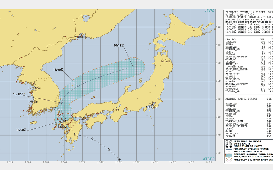
1 p.m. Wednesday, Aug. 14, Japan time: Fleet Activities Sasebo has set Tropical Cyclone Condition of Readiness All Clear. Closest point of approach to Sasebo Naval Base has come and gone.Tropical Storm Leepi has weakened to 40-mph sustained winds and 52-mph gusts and is making a wide arc northeast into the Sea of Japan, where it's forecast to die out late Thursday evening. This is the final report on Leepi.11:45 p.m. Tuesday, Aug. 14, Japan time: Talk about your sudden change in flight plan. Rather than arcing southwest away from Korea after passing close to Sasebo Naval Base, Tropical Storm Leepi is now forecast to blast straight through to the heart of the Korean peninsula, according to the Joint Typhoon Warning Center's latest forecast track. At 11:30 p.m., Leepi was 247 miles east-southeast of Sasebo, headed northwest at 18 mph and was holding steady at 63-mph sustained winds and 81-mph gusts. Its new forecast still shows Leepi weakening as it approaches the east coast of Kyushu in southwestern Japan. Leepi is forecast to pass 102 miles southwest of Marine Corps Air Station Iwakuni at 7 a.m. Wednesday and 52 miles northwest of Sasebo just three hours later, still packing 52-mph sustained winds and 63-mph gusts. Southeasterly winds should peak between 30- and 40-mph sustained with 52-mph gusts as Leepi roars past Sasebo, according to Fleet Activities Sasebo's weather portal. But Leepi is then due to keep heading straight northwest, making a near-direct hit on Pusan with 40-mph sustained winds and 52-mph gusts at 10 p.m. Wednesday, then burrowing through to the heart of the Korean peninsula, where it's forecast to dissipate.7:30 p.m. Tuesday, Aug. 14, Japan time: Fleet Activities Sasebo has set Tropical Cyclone Condition of Readiness Storm Watch, in advance of the forecast arrival/passage of Tropical Storm Leepi. At 3 p.m., Leepi was 315 miles south-southeast of Marine Corps Air Station Iwakuni, headed northwest at 17 mph, packing 63-mph sustained winds and 81-mph gusts, according to the Joint Typhoon Warning Center. If Leepi continues moving as forecast, it will continue to weaken as it makes landfall early Wednesday morning over the east coast of Kyushu in southwestern Japan. Leepi is forecast to pass 117 miles southwest of Iwakuni at 6 a.m. Wednesday, still packing 58-mph sustained winds and 75-mph gusts. But that's at storm's center. Iwakuni is well shielded by hills and mountains and destructive winds extend only 40 miles northeast of center, JTWC reports. Sasebo is next on the itinerary. Leepi is forecast to pass 23 miles northeast of Sasebo at 1 p.m. Wednesday, still packing 52-mph sustained winds and 63-mph gusts. Even Korea's southeast coast might feel some effects. JTWC projects Leepi to pass 69 miles south of Pusan and 58 miles south of Chinhae Naval Base between 11 a.m. and 4 p.m. Thursday, still carrying 40-mph sustained winds and 52-mph gusts.2:30 p.m. Tuesday, Aug. 14, Japan time: Now it appears Tropical Storm Leepi has put Sasebo Naval Base in its sights for a mid-morning Wednesday rendezvous, according to the Joint Typhoon Warning Center. Leepi is still packing 69-mph sustained winds and 86-mph gusts as it moves northwest toward Kyushu. Leepi is expected to cross Japan's southwesternmost main island, then pass 18 miles south of Sasebo at 10 a.m. Wednesday, still packing 46-mph sustained winds and 58-mph gusts at center. Sasebo remains in Tropical Cyclone Condition of Readiness All Clear; that could change, depending on forecast track and Leepi's forecast intensity. Sasebo could see TCCOR Storm Watch by day's end.11:30 p.m. Monday, Aug. 13, Japan time: Leepi continues to wiggle-waggle back and forth between typhoon and tropical storm status, having opted for the latter over the last six hours, according to the Joint Typhoon Warning Center. At 9 p.m., Leepi was 622 miles southeast of Sasebo Naval Base, moving northwest at 13 mph and packing 63-mph sustained winds and 81-mph gusts at center. If Leepi continues moving as forecast, expect Marine Corps Air Station Iwakuni and Sasebo to be well out of harm's way, both due to forecast track and a continued weakening trend over the next day or so. Leepi is forecast to pass 246 miles south of Iwakuni at 1 a.m. Wednesday, with 40-mph sustained winds and 52-mph gusts at center, and 128 miles south of Sasebo seven hours later as a tropical depression.8:10 p.m. Monday, Aug. 13, Japan time: Just like that, Leepi is a Category 1-equivalent typhon once more, packing 75-mph sustained winds and 92-mph gusts. But it remains well offshore and in no position to harm land for at least a couple of days, according to the Joint Typhoon Warning Center. At 3 p.m., Leepi was 700 miles southeast of Sasebo Naval Base, headed northwest at 14 mph. If Leepi remains on its present path, it will gradually weaken, down to 46-mph sustained winds and 58-mph gusts as it passes 120 miles south of Sasebo at 6 a.m. Wednesday.2:10 p.m. Monday, Aug. 13, Japan time: Leepi has been downgraded to a tropical storm by the Joint Typhoon Warning Center. But it's due to reintensify into a Category 1-equivalent typhoon by Monday evening. It should briefly remain a typhoon before gradually weakening as it moves north, passing 242 miles south of Marine Corps Air Station Iwakuni at 9 p.m. Tuesday and 122 miles southwest of Sasebo Naval Base 6 hours later, still packing 58-mph sustained winds and 75-mph gusts. Sasebo and Iwakuni remain Tropical Cyclone Condition of Readiness All Clear.11;30 p.m. Sunday, Aug. 12, Japan time: Leepi has been upgraded to a Category 1-equivalent typhoon, but remains on course to avoid most major land masses, according to the Joint Typhoon Warning Center's latest forecast track. At 11 p.m., Leepi was 890 miles east of Kadena Air Base, Okinawa, moving north-northwest at 10 mph packing 75-mph sustained winds and 92-mph gusts. If Leepi remains on its present path, it's due to pass 38 miles southwest of Iwo Jima at 2 a.m. Monday, retaining the same wind values. JTWC reports that Leepi has reached peak intensity and is due to arc northwest, but remain away from Japan's main islands. Marine Corps Air Station Iwakuni should remain well out of harm's way; Leepi is forecast to pass 276 miles south at 9 p.m. Tuesday, then 10 hours later pass 159 miles southwest of Sasebo Naval Base as a strong tropical storm. Leepi is forecast to continue weakening, passing at 9 p.m. Tuesday only over Tanegashima and Yakushima, sparsely populated islands just south of Kagoshima in Kyushu, then die out in the East China Sea at midweekas cooler sea-surface temperatures and vertical wind shear affect the system.11:15 p.m. Saturday, Aug. 11, Japan time: A new tropical cyclone spawned overnight Friday and very quickly strengthened into a tropical storm by Saturday evening. 19W is forecast to intensify into a Category 1-equivalent typhoon by mid-morning Sunday, but weaken gradually as it makes its way northwest in the general direction of southwestern Japan. This one bears watching.
