()
5 a.m. Wednesday, Jan. 3, Philippines time: It doesn’t appear as if Tropical Depression 01W will peak any higher than its current 35-mph sustained winds and 46-mph gusts, as it has exited Palawan Island and is moving west over the South China Sea, according to the Joint Typhoon Warning Center.
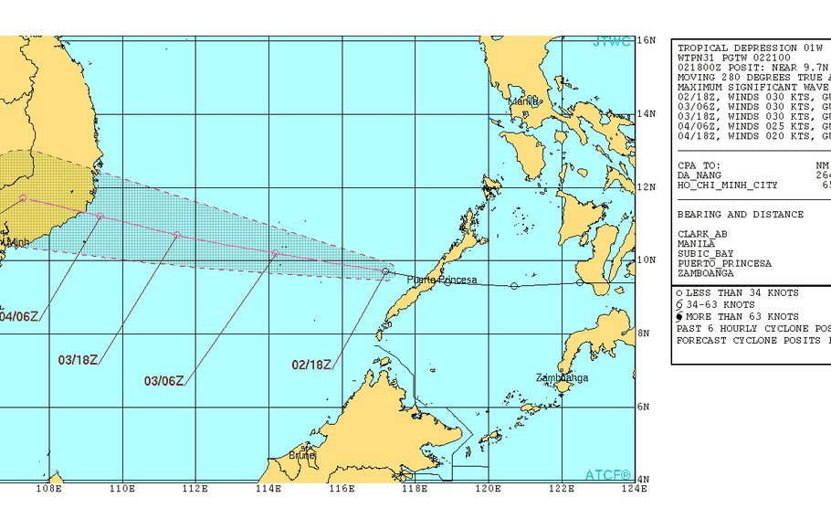
At 2 a.m., 01W was 425 miles southwest of Manila, headed almost due west at 19 mph. Tropical Storm Warning Signal 1 has been lowered for all areas of the Philippines. If 01W continues on its current track, it’s forecast to make landfall over Vietnam early Thursday evening as a weak tropical depression. Unless things change drastically, this is PST’s final report on 01W.
5 p.m. Tuesday, Jan. 2, Philippines time: Tropical Depression 01W has moved out over the Sulu Sea and is headed toward Palawan Island, according to the Joint Typhoon Warning Center. It's forecast to peak at no more than tropical-depression strength and continue west over the South China Sea toward Vietnam, with landfall forecast for Thursday evening. At 2 p.m., 01W was 366 miles south of Manila, headed west at 20 mph, holding steady at 35-mph sustained winds and 46-mph gusts. If it remains on its present path, 01W is forecast to peak at no higher than 40-mph sustained winds and 52-mph gusts, passing 16 miles south of Puerto Princesa at 9 p.m. Monday. Tropical Cyclone Warning Signal 1 remains raised only for Palawan including Cuyo Island and has been lowered for all other areas of the Philippines, according to national weather authority PAGASA. Model guidance is in general agreement on a track toward central Vietnam in the next two days. JTWC projects landfall over southeastern Vietnam by early evening Thursday, with closest point of approach 137 miles north-northeast of Ho Chi Minh City at 1 p.m. Friday.3 p.m. Tuesday, Jan. 2, Philippines time: Tropical Cyclone Warning Signal 1 has been lifted for all areas of the Philippines except for western Palawan, according to national weather authority PAGASA.11:15 a.m. Tuesday, Jan. 2, Philippines time: Tropical Depression 01W is now over Sulu Sea, having left the Visayas region of the central Philippines. If it remains on its present course, 01W should pass 9 miles north of Puerto Princesa on Palawan Island at about 8 p.m. Tuesday before heading over the South China Sea.Tropical Storm Warning Signal 1 remains raised for Palawan, including Cuyo Island, and western areas of Visayas, according to the national weather authority PAGASA.10 a.m. Tuesday, Jan. 2, Philippines time: Tropical Depression 01W is exiting the Visayas region of the Philippines and is taking aim at a near direct hit on Puerto Princesa on Palawan Island, according to the Joint Typhoon Warning Center. At 8 a.m., 01W was 373 miles south-southeast of Manila, headed almost due west at 24 mph, holding steady at 35-mph sustained winds and 46-mph gusts. 01W is forecast by JTWC to peak at 46-mph sustained winds and 58-mph gusts at mid-morning Wednesday.9:30 a.m. Tuesday, Jan. 2, Philippines time: Tropical Storm Warning Signal 1 has been lowered for Mindanao, and remains raised for Palawan and portions of Visayas, according to the national weather authority PAGASA.7:30 a.m. Tuesday, Jan. 2, Philippines time: Well, that didn’t take long.
We have the first numbered storm of the northwest Pacific’s tropical cyclone season just two days into the New Year. Definitely a lot quicker than the last two years; in 2016, the first one came in late May, while last year we had to wait until early July.
At 2 a.m., 01W was 434 miles southeast of Manila, tracking west at 18 mph through northern Mindanao, with 35-mph sustained winds and 46-mph gusts at center. 01W is forecast to track quickly through Mindanao into the Sulu Sea, make a near-direct hit on Puerto Princesa on southwestern Palawan Island late Tuesday evening, then head through the South China Sea into Vietnam at mid-morning Friday.
Tropical Storm Warning Signal 1 remains raised for Palawan and several areas in Visayas and Mindanao, according to the national weather authority PAGASA.
11 p.m. Monday, Jan. 1, Philippines time: A tropical cyclone formation alert has been issued by the Joint Typhoon Warning Center on the developing system east of Mindanao, the Philippines’ southernmost and largest island. The developing system is forecast to make landfall in the Caraga area of Mindanao sometime Monday night or early Tuesday morning. Tropical Cyclone Warning Signal 1 remains raised for portions of east Mindanao and Visayas.
Model guidance shows the system heading quickly through Mindanao overnight into Tuesday, then over the Sulu Sea and Palawan Island into Wednesday and on into the South China Sea. This would become the first storm numbered by JTWC in 2018 – which would mark a much faster start to the northwest Pacific tropical cyclone season than the last two years; the first numbered storms didn’t occur until May of 2016 and July of 2017. If it becomes a named storm, it would be called Bolaven, Laotian for a plateau in the southern part of Laos.
6 p.m. Monday, Jan. 1, Philippines time: Happy New Year, or Maligayang bagong taon. A new tropical depression has formed east of the Philippines’ southernmost island of Mindanao and appears to be taking the same track as Tropical Storm Tembin did right around Christmas, according to model guidance and the Philippines national weather authority PAGASA.
The system, labeled 99W Invest, has been designated a tropical depression by PAGASA and is called Agaton. Model guidance https://www.tropicaltidbits.com/storminfo/99W_tracks_latest.png shows it crossing Mindanao, along the same course taken by Tembin, but should remain a tropical depression before heading over the South China Sea.
Tropical Storm Warning Signal 1 https://www1.pagasa.dost.gov.ph/index.php/tropical-cyclones/weather-bulletins is raised for portions of eastern Mindanao and southern Leyte in Visayas, according to PAGASA. PAGASA advises residents to beware of heavy rain, flooding and possible landslides in the area.
