(U.S. Navy)
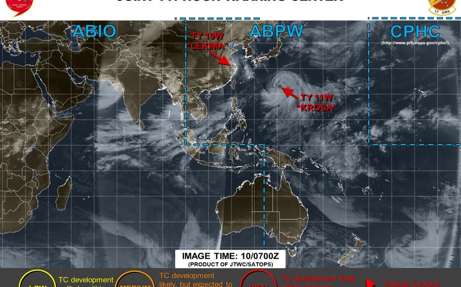
11:45 a.m. Saturday, Aug. 10, east China time: Head's up, Shanghai! You might be receiving a visitor later Saturday. At 8 a.m., Lekima was still a typhoon, barely, and 155 miles south of Shanghai, moving north-northwest at 8 mph still packing 86-mph sustained winds and 104-mph gusts as it treks through east China. A red warning of typhoon remains in effect, according to the China Meteorological Agency. If Lekima keeps on its present heading, it's forecast to remain inland, passing 61 miles west of Shanghai at 10 p.m., still packing 69-mph sustained winds and 86-mph gusts as it roars past. Lekima is forecast to keep skimming China's east coast, finally dissipating as it reaches the Gulf of Pohai to the northeast. Unless there's a change in track, unless it moves more toward Korea or Japan (not likely), this is the final report on Lekima.11;45 p.m. Friday, Aug. 9, Japan time: Typhoon Lekima has its sights set on landfall over Wenzhou, south of Shanghai, overnight Friday into Saturday and is forecast to make a long run up China's east coast, according to the Joint Typhoon Warning Center. At 9 p.m., Lekima was 170 miles north-northeast of Taipei, moving northwest at 7 mph, still packing 110-mph sustained winds and 132-mph gusts. If it maintains its present heading, it's due to pass 56 miles west of Shanghai late Saturday evening, steadily weakening as it trudges north.Heavy rain warnings remain in effect for much of Taiwan, according to the Central Weather Bureau. A red typhoon warning remains in effect for China's east coast, according to the China Meteorological Agency. How much weaker it gets, depends on how deep inland Lekima actually goes. JTWC projects Lekima to follow the coastline, well up along the Yellow Sea, and weaken into a tropical depression late Wednesday evening.Model track guidance remains divided and the GFS and CMC forecast ensembles quite scattered, with some solutions actually showing Lekima circling toward Japan and/or the Korean peninsula. Or it might dissipate over China Stay tuned.6:45 p.m. Friday, Aug. 9, Japan time: U.S. bases on Okinawa have resumed seasonal Tropical Cyclone Condition of Readiness 4. Typhoon Lekima continues moving northwest and out of the area and is not forecast to return. Storm Tracker is keeping an eye on Lekima as model guidance and forecast ensembles indicate a chance that Lekima might turn east or south toward Korea and/or Japan next week.Noon Friday, Aug. 9, Japan time: Lekima was downgraded from super-typhoon status overnight, but remains a powerful Category 4-equivalent storm, making its way toward the Chinese coast, where it's forecast to remain into next week, weakening all the way. At 9 a.m., Lekima was 271 miles west of Kadena Air Base, Okinawa, moving northwest at 16 mph, packing 132-mph sustained winds and 161-mph gusts. U.S. bases on Okinawa remain in Tropical Cyclone Condition of Readiness Storm Watch.Kadena's extended weather forecast calls for current conditions -- gusty winds, scattered showers and isolated thunderstorms -- to continue through the weekend. Lekima had some serious effects on the Yaeyama islands in southwestern Japan, according to the Okinawa Times. More than 13,000 homes lost power and four people suffered wind-related injuries on Miyako. Some 128 flights were canceled, affecting more than 14,000 passengers on Thursday, and Japan Transocean Air, All Nippon Airways and Ryukyu Air Commuter announced 68 flights were canceled Friday, affecting 6,200 passengers; 245 ferries were canceled Thursday and 155 more on Friday. A typhoon warning has been issued for northern provinces in Taiwan, according to the Central Weather Bureau. Lekima is forecast to pass 145 miles northeast of Taipei at 11 a.m. local time.12:15 a.m. Friday, Aug. 9, Japan time: Tiny Tarama Island, all of 8.46 square miles situated between Ishigaki and Miyako in southwestern Japan about 225 miles from Okinawa, appears to have Super Typhoon Lekima in its sights. At midnight Thursday, Lekima was 220 miles southwest of Kadena Air Base, pushing northwest at 12 mph and holding steady at 150-mph sustained winds and 184-mph gusts. U.S. bases on Okinawa remain in Tropical Cyclone Condition of Readiness Storm Watch. If Lekima stays on its present heading, Tarama is its next target sometime early Friday morning. From there, Lekima remains forecast to head northwest and make landfall over eastern China at 8 a.m. Saturday, weakening rapidly as it passes 32 miles west of Shanghai at 9 a.m. Sunday and dissipate inland.7:30 p.m. Thursday, Aug. 8, Japan time: U.S. bases on Okinawa were placed in Tropical Cyclone Condition of Readiness Storm Watch at 7 p.m. Peak forecast winds and closest point of approach have come and gone, according to the Joint Typhoon Warning Center and Kadena Air Base's 18th Wing Weather Flight. Super Typhoon Lekima's closest point of approach was 246 miles southwest at 5 p.m. Peak 40-mph sustained winds and 52-mph gusts were recorded at 2:53 p.m.5:30 p.m. Thursday, Aug. 8, Japan time: Mercy sakes alive! Lekima's intensity ramped up big time in the last six hours, and it is now a Category 5-equivalent super typhoon, according to the latest from the Joint Typhoon Warning Center. That said, U.S. bases on Okinawa still remain out of the path of Lekima's absolute worst. U.S. bases remain in Tropical Cyclone Condition of Readiness 1. Forecast closest point of approach to Kadena Air Base by Lekima has come and gone, 246 miles southwest at 5 p.m. Forecast wind values for the island remain as previously reported for the moment; an updated wind-forecast timeline will be posted when available. At 3 p.m., Lekima was 246 miles southwest of Kadena, heading north-northwest at 12 mph and had dramatically strengthened to 150-mph sustained winds and 184-mph gusts. Talk about a monster. If Kelima remains on its present heading, it's forecast to gradually weaken as it makes a near-direct hit on Ishigaki, with Miyako to its east feeling some serious nastiness from Lekima's stronger east quadrants. Lekima is forecast to pass 102 miles northeast of Taipei at 1 p.m. Friday, then make for the east coast of China, coming ashore at 2 p.m. Saturday still packing 104-mph sustained winds and 127-mph gusts, then making a near-direct hit on Shanghai at 2 p.m. Sunday as a significant tropical storm. A typhoon warning is in effect for east and north provinces of Taiwan with a heavy rain warning covering most of the provinces in the island nation, according to Taiwan's Central Weather Bureau. The Batanes and Babuyan island groups in the northern Philippines remain under Tropical Cyclone Warning Signal 1, according to the national weather authority PAGASA. Apropos of nothing: This is the second super typhoon of the northwest Pacific's tropical cyclone season, behind Wutip in February.1 p.m. Thursday, Aug. 8, Japan time: Here's the latest wind-forecast timeline for Okinawa, brought to you by Typhoon Lekima and courtesy of Kadena Air Base's 18th Wing Weather Flight. U.S. bases on Okinawa remain in Tropical Cyclone Condition of Readiness 1. There is no set time for any accelerated TCCORs; it's all up to the winds now, how strong they get and when. -- Onset of 35-knot (40-mph) sustained winds: 3 p.m. Thursday. -- Onset of 50-knot (58-mph) sustained winds: Not forecast at this time. -- Peak 35-knot (40-mph) sustained winds and 45-knot (52-mph) gusts for Kadena, 40-knot (46-mph) sustained winds and 50-knot (58-mph) gusts: 8 p.m. Thursday. -- Winds subsiding below 35 knots (40 mph) sustained: 3 p.m. Friday. Between 2 and 4 inches of rain associated with Lekima is forecast for Kadena.All this can change! This is weather. Stay tuned to Pacific Storm Tracker, AFN which is now on 24-hour storm operations, your base's TV access channel and official Facebook page. Lekima is forecast to pass 268 miles southwest of Kadena at 8 p.m. Thursday, according to the Joint Typhoon Warning Center's latest forecast track. That's a good way's away, but this is a vast storm, currently 512 miles in diameter, according to the Joint Typhoon Warning Center's latest forecast track. Though Lekima's 64- and 50-knot wind bands are tucked deep inside the storm, the 34-knot bands extend as far as Okinawa, and that's what the island is experiencing right now! Every chance those winds could increase and become destructive, but there's no telling when or if that may happen. Beyond Okinawa, Lekima is forecast to peak at 138-mph sustained winds and 167-mph gusts at mid-evening Thursday, making a near-direct hit on Ishigaki, bypassing Taiwan, then skim the coast of China over the weekend, gradually weakening as it moves north.9 a.m. Thursday, Aug. 8, Japan time: U.S. bases on Okinawa entered Tropical Cyclone Condition of Readiness 1 at 9 a.m. Destructive winds of 58 mph or greater are anticipated within 12 hours. By definition, here's what TCCOR 1 means and what you should do to prepare: No school for DODEA students. Staff and teachers will work normal hours, unless changed by the DODEA district superintendent. Fill any containers you can use for water storage. If you live in low-lying quarters, make arrangements to stay with a friend living on higher ground. Make final check of food and other supplies. As for what occurs after this: It is all up to the winds. There is NO set time for when TCCOR 1C or 1E will hit. If 35-knot (40-mph) sustained winds are recorded on a particular base, TCCOR 1-C would be issued. If winds then hit 50 knots or 58 mph sustained, that would meet the criteria for TCCOR 1-E. Stay tuned to AFN, your base's official Facebook page, your base official commander's TV access channel and Pacific Storm Tracker for the latest.7 a.m. Thursday, Aug. 8, Japan time: Here's the latest wind-forecast timeline for Okinawa from Typhoon Lekima courtesy of Kadena Air Base's 18th Wing Weather Flight. U.S. bases on Okinawa remain in Tropical Cyclone Condition of Readiness 2. -- Onset of 40-mph sustained winds: Noon Thursday. -- Onset of 58-mph sustained winds: Not forecast at this time. --Peak 40-mph sustained winds, 52-mph gusts for Kadena; 46-mph sustained winds, 58-mph gusts elsewhere, 5 p.m. Thursday. -- Winds subsiding below 40-mph sustained: Noon Friday. Between 2 to 4 inches of rain associated with Lekima is forecast.All this can change, depending on Lekima's forecast track and projected wind speeds. Stay tuned.6 a.m. Thursday, Aug. 8, Japan time: Little change at this point to the heavy predictions regarding Typhoon Lekima. Closest point of approach to Kadena Air Base remains the same as previously reported, a good distance away from island, 281 miles southwest, but at 5 p.m. Thursday, instead of 6 p.m. U.S. bases on Okinawa remain in Tropical Cyclone Condition of Readiness 2. At 3 a.m., Lekima was 316 miles south-southwest of Kadena, traveling northwest at 8 mph, packing 127-mph sustained winds and 155-mph gusts, riding the fence between Category 3- and 4-equivalent intensity. A nasty monster, this one is. Joint Typhoon Warning Center projects Lekima to continue intensifying, but stopping just short of super-typhoon status, 144-mph sustained winds and 173-mph gusts at 3 a.m. Friday as it passes just southwest of Ishigaki island in southwestern Japan. Long-term, Lekima remains forecast to pass 71 miles northeast of Taipei at 3 p.m. local time Friday, then skim the east coast of China, making a near-direct hit on Shanghai at noon local time Sunday, gradually weakening as it heads north. Updated wind-forecast timeline to be posted when available.1 a.m. Thursday, Aug. 8, Japan time: Here is the latest wind forecast timeline for Typhoon Lekima, courtesy of Kadena Air Base's 18th Wing Weather Flight. U.S. bases on Okinawa remain in Tropical Cyclone Condition of Readiness 2. -- Sustained 40-mph winds: Noon Thursday. -- Sustained 58-mph winds: Not forecast to occur. -- Peak forecast winds: 40-mph sustained, 52-mph gusts for Kadena, 46-mph sustained, 58-mph gusts elsewhere, 6 p.m. Thursday. -- Winds subsiding below 40-mph sustained: 3 a.m. Friday. Between 2 to 4 inches of rain associated with Lekima is forecast.All this could change! Please stay tuned to Storm Tracker for updates.Midnight Wednesday, Aug. 7, Japan time: Talk about turning into a big beast.Lekima has rapldly intensified into a Category 2-equivalent typhoon and is forecast by the Joint Typhoon Warning Center to peak as a super typhoon late Thursday evening just south of Ishigaki in southwestern Japan. For the moment, U.S. bases on Okinawa continue to remain out of harm's way and in Tropical Cyclone Condition of Readiness 2. No recommendation has been made at this point to accelerate to TCCOR 1 yet, according to Kadena Air Base's 18th Wing Weather Flight. Damaging 40-mph sustained winds remain forecast to kick up at about noon Thursday. Destructive winds of 58 mph or greater are not forecast to occur, according to Kadena's extended forecast. At 9 p.m., Lekima was 340 miles south of Kadena, moving northwest at 11 mph and had strengthened to 115-mph sustained winds and 144-mph gusts at center, and sporting a well-defined eye. JTWC projects Lekima to peak at 150-mph sustained winds and 184-mph gusts at 9 p.m. Thursday as it approaches Ishigaki. Closest point of approach to Kadena is 281 miles southwest at 6 p.m. Thursday. After its northwest trek toward Ishigaki, Lekima is forecast to curve poleward, passing 75 miles east of Taipei at 3 p.m. local time Friday, then push north along the east coast of China, passing 16 miles east of Shanghai at noon local time Sunday, gradually weakening along the way.Model track guidance, the GFS and CMC ensembles all mirror the JTWC's forecast track short term taking Lekima west of Okinawa. Long term, though, question marks linger over whether Lekima will continue straight north or bend northeast toward Korea or Japan. Stay tuned. An updated wind forecast timeline to be posted when available.8 p.m. Wednesday, Aug. 7, Japan time: Here is the wind forecast timeline for Typhoon Lekima, courtesy of Kadena Air Base's 18th Wing Weather Flight. U.S. bases on Okinawa remain in Tropical Cyclone Condition of Readiness 2. -- Sustained 40-mph winds: Noon Thursday. -- Sustained 58-mph winds: Not forecast to occur. -- Peak forecast winds: 40-mph sustained, 52-mph gusts for Kadena, 46-mph sustained, 58-mph gusts elsewhere, 5 p.m. Thursday. -- Winds subsiding below 40-mph sustained: 9 a.m. Friday. Between 2 to 4 inches of rain associated with Lekima is forecast.All this could change! Please stay tuned to Storm Tracker for updates.7 p.m. Wednesday, Aug. 7, Japan time: U.S. bases on Okinawa entered Tropical Cyclone Condition of Readiness 2 at 7 p.m. local time. Destructive winds of 58 mph or greater are anticipated within 24 hours. By definition, here's what happens when TCCOR 2 is issued: Finish removing or securing all outside items. As a last-minute precaution, gas up the car and visit the bank or the ATM to stock up on enough cash and local currency to last as long as three days. Pregnant women in their third trimester should contact 18th Medical Group or the U.S. Naval Hospital on Camp Foster about whether they should stay there for the duration of the storm. You may also notice that sales of alcohol will be cut off at the shoppette or Exchange at a certain point; that’s to ensure personnel are ready at a minute’s notice to help clean up storm damage or immediate emergencies, instead of being incapacitated by the “typhoon party.” TCCOR 2 was issued just as the commissaries were closing on the bases. Might not hurt to get there early Thursday to get whatever last-minute shopping needed done. More to come when a wind forecast timeline is issued.6:15 p.m. Wednesday, Aug. 7, Japan time: Man, Lekima looks like it's going to intensify into a monster. The latest Joint Typhoon Warning Center forecast track has it intensifying into a Category 4-equivalent typhoon as it reaches Ishigaki, an island 265 miles southwest of Okinawa, early Friday morning. At 3 p.m., Lekima was 386 miles south of Kadena Air Base, moving northwest at 9 mph and had strengthened to 98-mph sustained winds and 121-mph gusts, Category 2-equivalent intensity. Lekima is forecast to peak at 144-mph sustained winds and 173-mph gusts at 3 a.m. Friday, just below super-typhoon strength. The good news is, Lekima remains on course to pass far enough southwest that Okinawa should remain out of harm's way. Closest point of approach by Lekima to Kadena is forecast to be 277 miles west-southwest at 5 p.m. Thursday. U.S. bases remain in Tropical Cyclone Condition of Readiness 3; still no immediate recommendation to go to TCCOR 2 yet, according to Kadena's 18th Wing Weather Flight. Kadena's extended forecast calls for 40-mph sustained winds to begin at about noon Thursday. At this point, destructive 58-mph winds or greater are not forecast. The bad news is, Ishigaki is in the crosshairs for a serious pounding should Lekima remain on its present heading. And while Okinawa for the moment appears to be avoiding typhoon-intense winds, heavy crosswinds between 23 and 29 mph have already begun affecting Naha Airport, with some flights under check and delayed due to the high winds. Here are a couple of links, each in English, to help figure out status of flights just in case you or your relatives were planning to travel into or out of Okinawa in the next couple of days. From Ishigaki, Lekima is forecast to push northwest, then north, passing 75 miles northeast of Taipei, then skirt the east coast of China, passing 23 miles east of Shanghai at 11 p.m. local time Sunday, still packing 98-mph sustained winds and 121-mph gusts as it roars past. JTWC projects Lekima to keep moving along the Chinese coast into the Yellow Sea. Model track guidance roughly follows that route, as does the GFS ensemble, but with outliers. The CMC ensemble continues to favor a track along the south coast of Japan's main islands. One thing all of those have in common is, they indicate a track going around Okinawa to its west. While Okinawa can expect high winds and showers over the next few days, by all indications, it could have been -- or could yet be -- a lot worse.Noon Wednesday, Aug. 7, Japan time: It's still forecast to pass quite a ways southwest of Okinawa. Nothing to fear yet. But Typhoon Lekima's latest track shows it lurching to the right, bringing it between Taiwan and Ishigaki and about 70 miles closer to Okinawa than previously forecast. At 9 a.m., Lekima was 436 miles south of Kadena Air Base, moving north-northwest at 8 mph and had strengthened to 81-mph sustained winds and 98-mph gusts. U.S. bases on Okinawa remain in Tropical Cyclone Condition of Readiness 3. No recommendation has been made to go to TCCOR 2 yet, according to Kadena's 18th Wing Weather flight. If Lekima remains on its present heading, it's forecast to peak at 121-mph sustained winds and 150-mph gusts at 9 a.m. Friday. Closest point of approach to Okinawa is forecast for 273 miles west-southwest at 8 p.m. Thursday.Kadena's extended weather forecast indicates 40-mph sustained winds starting at 6 p.m. Thursday, with destructive 58-mph winds not forecast at this time. Long-term, Lekima is forecast to skirt the east coast of China and maintain typhoon intensity as it goes. Model track guidance keeps it headed west toward China, with a spread of 213 miles among solutions. Still, questions linger over where it heads from there. GFS ensemble continues to point it toward Korea, while CMC ensemble continues favoring a track toward Japan. And 96W Invest remains in play to the west near Luzon. Stay tuned.6 a.m. Wednesday, Aug. 7, Japan time: Lekima has been upgraded to a typhoon by the Joint Typhoon Warning Center, and is now forecast to peak as a Category 3-equivalent monster early Friday morning near Taiwan. U.S. bases on Okinawa continue remain out of harm's way, for the moment. At 3 a.m., Lekima was 484 miles south of Kadena Air Base, crawling west-northwest at 5 mph packing 75-mph sustained winds and 92-mph gusts as it continues on a wobbly path in Taiwan's general direction. If Lekima stays on its present heading, it's due to peak at 115-mph sustained winds and 144-mph gusts at 3 a.m. Friday as it approaches Taiwan's northeast coast. Closest point of approach to Kadena is forecast to be 342 miles southwest at 6 p.m. Thursday, just prior to reaching peak forecast intensity.Kadena's extended weather forecast calls for gusty easterly winds Wednesday, shifting to southeast and then south into the weekend, with anywhere from a 50- to 70-percent chance of showers, heavy at times, and scattered/isolated thunderstorms. Sustained 40-mph winds are forecast to begin at noon Thursday, but destructive 58-mph winds or greater are not expected at this time, according to Kadena's weather page and official Facebook page. Landfall over the northeast coast of Taiwan should occur late afternoon or early evening Friday, with closest point of approach to Taipei 7 p.m. local time Friday, gradually weakening as it interacts with land. Following that, JTWC projects Lekima to curve northeast, skimming China's east coast and gradually losing its punch as it moves north. But there's still that tinge of doubt, lingering questions over exactly where Lekima will track in the long term. There remains a long-term spread of about 230 miles in model track guidance, the GFS ensemble continues to depict a track across the Korean peninsula and the CMC ensemble continues favoring a sharper east turn toward the south coast of Japan's main islands. And there's the presence of a new tropical disturbance west of Luzon Island in the Philippines, 96W Invest. Will it be absorbed by Lekima, or will it develop into its own tropical cyclone? Time will tell. Stay tuned.Midnight Tuesday, Aug. 6, Japan time: Stronger, ever stronger, Tropical Storm Lekima is projected to become -- Category 2-equivalent strength -- and it has resumed its forecast dash northwest toward Taiwan, according to the Joint Typhoon Warning Center. U.S. bases on Okinawa remain in Tropical Cyclone Condition of Readiness 3 and out of harm's way for now, though the new JTWC forecast track edges it a wee bit closer to Kadena Air Base. It's still a waiting game. At 9 p.m., Lekima was 472 miles south of Kadena and had picked up forward speed, northwest at 9 mph and had seriously strengthened, now 69-mph sustained winds and 86-mph gusts, just below typhoon intensity. Should Lekima remain on its present heading, it's forecast to peak at 104-mph sustained winds and 127-mph gusts late Thursday as it passes just southwest of Ishigaki in southwestern Japan. Closest point of approach to Kadena is forecast to be 339 miles southwest at 3 p.m. Thursday as Lekima approaches that peak forecast intensity. It should gradually weaken as it approaches Taiwan, with closest point of approach to Taipei, the capital, now forecast for 6 miles northeast at 3 p.m. Taiwan time on Friday, still packing 86-mph sustained winds and 104-mph gusts. From there, Lekima is due to curve northeast through the Formosa into the east coast of China, making secondary landfall late Saturday evening and stay along the coast, approaching Shanghai late Sunday evening. That's where the guessing game resumes regarding Lekima's long-term prospects.Model track guidance continues to push Lekima northwest toward Taiwan and China. The GFS ensemble favors the JTWC track but takes Lekima further northeast across the Korean peninsula late next week, while the CMC ensemble continues to favor a track along the south coast of Japan's main islands. Plenty of outliers among each ensemble. So while things might be looking more optimistic for Okinawa, so many questions linger regarding Lekima's long-term future.Not to mention how much stronger it might become in the near term. Stay tuned. This could get interesting.5:45 p.m. Tuesday, Aug. 6, Japan time: Almost like a lion crouching and getting ready to spring, Tropical Storm Lekima has curved toward the northwest, moving almost quasi-stationary but getting ready to motor quickly toward Taiwan, according to the Joint Typhoon Warning Center. At risk of sounding like a broken record, questions still linger over Lekima's long-term movement. Model track guidance and the GFS and CMC ensembles by and large depict Lekima moving northwest toward Taiwan, minus some outliers, and then toward China. But does that mean well inland in China? Or will Lekima glance off the east coast and then back over water in the East China Sea? Okinawa appears out of harm's way regardless, but might Lekima track between Korea and Kyushu (GFS ensemble) or skim Japan's main islands (CMC ensemble)? Hard to tell right now. Rest assured, Storm Tracker is all over it. At 3 p.m., Lekima was 516 miles south of Kadena Air Base, Okinawa, crawling northwest at 4 mph and had strengthened to 58-mph sustained winds and 75-mph gusts. Lekima is forecast to peak at 86-mph sustained winds and 104-mph gusts at 3 p.m. Thursday, an hour after it's due to pass 354 miles southwest of Kadena. U.S. bases remain in Tropical Cyclone Condition of Readiness 3. No recommendation yet to accelerate to TCCOR 2, according to Kadena's 18th Wing Weather Flight. If Lekima stays on its present heading, it should pick up forward speed this evening, keep moving northwest toward Taiwan, make landfall at mid-day Friday and pass 21 miles south of Taipei at 3 p.m. Friday, packing 75-mph sustained winds and 92-mph gusts. As for what Lekima does long-term, please stay tuned and we'll try to get those answers for you when available. At this point, the only thing certain remains uncertainty.11:15 a.m. Tuesday, Aug. 6, Taiwan time: Not much change to Tropical Storm Lekima. It remains forecast to start moving northwest Tuesday evening and pass just south of Taipei at mid-day Friday, with Okinawa remaining out of harm's way for the moment. At 8 a.m., Lekima was 538 miles south of Kadena Air Base and was quasi-stationary, moving northeast at just 2 mph, holding steady at 52-mph sustained winds and 63-mph gusts at center. U.S. bases remain in Tropical Cyclone Condition of Readiness 3. And model track guidance has come into much better agreement on Lekima tracking west toward Taiwan and China. The GFS ensemble mirrors that, while the CMC ensemble still favors a best track closer to Okinawa. Still a wait-and-see game, but not as much of a spread as before. If Lekima remains on its present projected course, it's forecast to peak at Category 1-equivalent intensity, 81-mph sustained winds and 98-mph gusts at mid-morning Thursday, south of Ishigaki island in southwestern Japan. JTWC projects Lekima to weaken slightly as it heads toward Taiwan, making landfall over the northeast coast early Friday morning, then passing 18 miles south of Taipei at high noon, still packing 75-mph sustained winds and 92-mph gusts. Closest point of approach to Kadena is 360 miles west-southwest at mid-day Thursday. Kadena's extended weather forecast calls for easterly sustained 32-mph winds and 46-mph gusts on Thursday, with showers and thunderstorms, up to a 60-percent chance into the weekend.5:20 a.m. Tuesday, Aug. 6, Taiwan time: Tropical Storm Lekima once more is forecast to peak as a Category 1-equivalent typhoon, and remains on course to pound the east coast of Taiwan early Friday, according to the Joint Typhoon Warning Center. Yes, there still remains a vast spread among model track guidance and the GFS and CMC forecast ensembles, though not as much as a day or two ago. Still, questions linger over exactly which way Lekima will head long term. At 2 a.m., Lekima was 551 miles south-southeast of Kadena Air Base, Okinawa, crawling southwest at 4 mph and had intensified slightly, to 52-mph sustained winds and 63-mph gusts. U.S. bases on Okinawa remain in Tropical Cyclone Condition of Readiness 3. If Lekima remains on its present heading, it should turn right and start heading northwest, peaking at 75-mph sustained winds and 92-mph gusts at about 2 a.m. Thursday, but well to Okinawa's southwest. JTWC projects Lekima to pass 360 miles west-southwest of Kadena at 9 a.m. Thursday, make landfall over Taiwan's northeast coast at 3 a.m. Friday, then pass 41 miles south-southwest of Taipei at noon Friday, still at peak forecast intensity. From there, Lekima is due to curve through the Formosa Strait and make secondary landfall over China's east coast, rapidly losing its along the way. If it keeps moving according to the JTWC forecast. Stay tuned.Midnight Monday, Aug. 5, Japan time: Lekima is no longer forecast to become a typhoon, at least for now. After slowing down some, it's due to pick up forward speed late Tuesday and is putting Taipei in its sights for a mid-afternoon Friday rendezvous, according to the Joint Typhoon Warning Center. At 9 p.m., Tropical Storm Lekima was 672 miles south-southeast of Kadena Air Base, Okinawa, moving southwest at 6 mph and holding steady at 46-mph sustained winds and 58-mph gusts. U.S. bases on Okinawa remain in Tropical Cyclone Condition of Readiness 3. Lekima is forecast to pass 333 miles west-southwest of Kadena at 9 a.m. Thursday. If Lekima stays on its present heading, it's forecast to head northwest late Tuesday, clip the northeastern tip of Taiwan about noon on Friday, then make a direct hit on Taipei at 3 p.m., packing 63-mph sustained winds and 81-mph gusts. Lekima is next forecast to knife through the Formosa Strait and hit the east coast of China, losing its punch as it interacts with the rugged coastline just south of Shanghai.Model track guidance is coming into better agreement, as are the GFS and CMC forecast ensembles, which each depict a curve northeast toward Japan. But that's a long way out yet. Stay tuned for further developments.6:30 p.m. Monday, Aug. 5, Japan time: There's a very strong possibility that Tropical Storm Lekima might make a near-direct hit on Taipei, then plow ashore over eastern China, well away from Okinawa, according to the Joint Typhoon Warning Center's latest forecast track. Vastly different from previous forecasts. Still, there remains quite a spread among model track guidance, with the GFS ensemble mirroring the JTWC track, but the CMC ensemble still showing a track closer to Okinawa. The latter two indicate a northeast track toward Japan to follow. A clearer picture, but many question marks still linger, with precious few answers at this point. At 3 p.m., Lekima was 525 miles south-southeast of Kadena Air Base, crawling northwest at 6 mph and holind steady at 40-mph sustained winds and 52-mph gusts. If Lekima remains on its present heading, it's forecast to keep moving northwest, peaking at 75-mph sustained winds and 92-mph gusts at mid-afternoon Thursday, then gradually weakening as it heads toward Taiwan's northeast coast. Lekima is now due to pass 328 miles west-southwest of Kadena at 11 a.m. Thursday. U.S. bases on Okinawa remain in Tropical Cyclone Condition of Readiness 3; destructive winds of 58 mph or greater remain possible within 48 hours. Lekima is then forecast to make landfall over northeast Taiwan, passing 20 miles south of Taipei at noon Friday, having weakened to 69-mph sustained winds and 86-mph gusts. Secondary landfall over China would follow early Saturday morning. There's also questions about how much 95W Invest, well to the east in the Northern Marianas Islands, might affect Lekima, if at all. This one bears watching. Stay tuned.Noon Monday, Aug. 5, Japan time: U.S. bases on Okinawa entered Tropical Cyclone Condition of Readiness 3 at 10 a.m. Monday due to Tropical Storm Lekima. Destructive winds of 58 mph or greater are possible within 48 hours. By definition, here's what else TCCOR 3 means: "Begin a general cleanup around homes and office. Bring inside or tie down bicycles to a concrete structure. Take down the trampoline and move it inside. Do the same with the hibachi or barbeque. Even plastic pails can become dangerous projectiles in a storm. Don’t tape windows; these days, windows of both on- and off-base structures are coated to protect from UV rays and are also designed to withstand sustained destructive winds for extended periods. Taping them might damage them. If you’ve not visited the PX or commissary, now’s the time to do so, to avoid the late rush." All that despite the fact that there remains much doubt as to exactly which way Lekima will go. A vast spread among model solutions remains, 265 miles three days out and nearly 1,100 miles five days out, according to the Joint Typhoon Warning Center.Model track guidance shows the center placed between central China and southwestern Japan. The GFS and CMC ensembles also remain all over the lot, with some solutions showing Lekima missing land entirely. Short answer: We still don't know. But we will keep an eye on it. At 9 a.m., Lekima was 551 miles south-southeast of Kadena Air Base, headed north-northwest at 7 mph and holding steady at 40-mph sustained winds and 52-mph gusts. If Lekima remains on its present heading -- if -- it's forecast to peak at 104-mph sustained winds and 127-mph gusts at center at 9 a.m. Saturday, a day or so after closest point of approach to Okinawa. Closest point of approach to Okinawa is forecast to be 277 miles west-southwest at 1 p.m. Friday. Lekima is due to pass 126 miles east-northeast of Taipei four hours later. Stay tuned to Storm Tracker and to your base's TV access channel and official Facebook pages for more.6:15 a.m. Monday, Aug. 5, Japan time: Lekima has been upgraded to a tropical storm by the Joint Typhoon Warning Center. Its latest forecast track takes it a bit closer to Taiwan and further away from Okinawa, but a vast spread remains among model track guidance and forecast ensembles. At 3 a.m., Lekima was 590 miles east-southeast of Kadena Air Base and had banked northwest, at 12 mph, and strengthened to 40-mph sustained winds and 52-mph gusts. U.S. bases on Okinawa remain in seasonal Tropical Cyclone Condition of Readiness 4. For now, Lekima forecast to peak at 110-mph sustained winds and 132-mph gusts at 3 a.m. Saturday as it approaches China's east coast. The question remains, will it head in that direction? Or more to the point, where will it head, period?Model track guidance still shows a vast spread, nearly 400 miles, with GFS continuing to depict a track into Taiwan and China, while GEM favors a track closer to Okinawa into South Korea, which is already threatened by Tropical Storm Francisco. And the GFS and CMC ensembles continue to show different solutions. Further complicating things is the presence of 95W Invest, just north of Guam. It might have some say in which way Lekima heads; some models are showing 95W becoming its own tropical cyclone and heading in Japan's general direction, while other solutions suggest 95W might be absorbed by Lekima. The short answer: It's still not clear what exactly will happen. It remains a guessing game at this point. For the moment, the extended forecast for Kadena calls for mostly cloudy to cloudy skies starting Wednesday, 29-mph easterly winds gusting up to 43 mph, with up to a 60-percent chance of showers and thunderstorms on Friday and winds shifting to the northeast on Thursday, 31-mph sustained and 46-mph gusts. That's assuming Lekima remains on its current heading. If it does, Lekima is forecast to pass 278 miles west-southwest of Kadena at midnight Thursday and 104 miles east-northeast of Taipei at 3 p.m. Friday. All this could change. And change again. Stay tuned.Midnight Sunday, Aug. 4, Japan time: For the moment, Tropical Depression Lekima has intensified slightly and according to the latest Joint Typhoon Warning Center forecast track remains on course to pass between Taiwan and Okinawa on Friday. But the spread in model track guidance is vast, with GFS depicting a track over Taiwan and into China, and NAVGEM favoring a track northeast toward Tokyo. And the GFS and CMC forecast ensembles also remain all over the lot, with some solutions suggesting Lekima might miss land entirely. In short, the only thing truly certain about Lekima remains uncertainty. Takes time for things to sort out and we get a clearer picture of where Lekima will end up. Another day or two. Meanwhile, at 9 p.m., Lekima was 656 miles south-southeast of Kadena Air Base, moving north at 13 mph and had strengthened slightly, to 35-mph sustained winds and 46-mph gusts. If Lekima stays on its present JTWC heading, it's forecast to turn northwest overnight Sunday into Monday, gradually strengthening, to a peak of 104-mph sustained winds and 127-mph gusts. At that peak forecast intensity, Lekima is forecast to pass about 200 miles southwest of Kadena at 7 a.m. Friday and 176 miles east-northeast of Taipei 14 hours later. Beyond that, for the moment, there's no way to definitively state what's next for Lekima. Stay tuned. More to come.6:15 p.m. Sunday, Aug. 4, Japan time: Only two things are close to certain regarding Tropical Depression 10W which has been named Lekima, for a Vietnamese fruit tree: -- Model guidance and forecast ensembles show it traveling in a generally northwest direction the next few days. -- Wherever it ends up, it could be quite a powerful storm, making for a wild, rainy and gusty ... whenever and wherever it does hit. Uncertainty continues to rule the late Sunday as 10W continues developing well south of Okinawa. A more clear picture would be nice, but give the GFS and CMC forecast ensembles a quick look and one would easily see why they call them "spaghetti models." And check the spread in model tracking guidance. Solutions are all over the lot. For the moment, the Joint Typhoon Warning Center's lateset forecast track continues to show 10W splitting the difference between Taiwan and Okinawa, and peaking at 92-mph sustained winds and 115-mph gusts as it splits that difference at mid-afternoon Thursday. At 3 p.m., 10W was 726 miles south-southeast of Kadena Air Base and had turned sharply left, moving northwest at 6 mph but holding steady at 29-mph sustained winds and 40-mph gusts. If 10W remains on its present heading, it's due to turn north, then northwest as we approach mid-week, gradually intensifying as it passes 215 miles west-southwest of Kadena Air Base and 194 miles east-northeast of Taipei at 3 p.m. Thursday. Where it goes from there, is too soon to say; JTWC forecasts five days out and no further. It remains a guessing game at this point. Much more should be known in a couple of days. Stay tuned.12:15 p.m. Sunday, Aug. 4, Japan time: The first warning has been issued on Tropical Depression 10W by the Joint Typhoon Warning Center. And the only thing certain at the moment is ... uncertainty. 10W is still forming well south of Okinawa, so it's a bit difficult to tell precisely how strong it might become and where exactly it might go in the coming days. Weather aware and be prepared, as the saying goes. Model track guidance and the GFS and CMC ensembles indicate a better than good chance that 10W could pack a good wallop for Okinawa by next weekend -- yes, the weekend, again. There's a reason they call them "spaghetti models." The GFS and CMC ensembles are picture positive of that. Anyhow, the time to start preparing is now. Begin that initial cleanup around the house and the office. Take note of what you have around the house in the way of non-perishable food, water, flashlights, portable radios and batteries, diapers and wipes and provisions for the furry friends. At 9 a.m., 10W was 758 miles south-southeast of Kadena Air Base, headed east-northeast at 7 mph with 29-mph sustained winds and 40-mph gusts. 10W is forecast to bank sharply left by late Sunday, then track north-northwest in the coming five days or so, splitting the difference between Taiwan and Kadena. For the moment, 10W is due to pass 222 miles west-southwest of Kadena and 200 miles east-northeast of Taipei at mid-morning Friday. But again, there's much uncertainty at the moment. No way to tell when or if it might hit Okinawa, when flights might be canceled, etc. It's a waiting game at this point.9 p.m. Saturday, Aug. 3, Japan time: Looks like Okinawa might get a windy visitor by next weekend. A tropical cyclone formation alert has been issued by the Joint Typhoon Warning Center on a disturbance labeled 94W Invest.
Model track guidance and the GFS and CMC forecast ensembles show this one has a chance of making for a wet, windy weekend for Okinawa, then possibly for southwestern Japan or even the Tokyo area. Stay tuned.
