(Joint Typhoon Warning Center)
6:30 p.m. Thursday, Aug. 15, Japan time: Closest point approach time for Tropical Storm Krosa to pass Marine Corps Air Station Iwakuni has come and gone. Krosa came within 26 miles east at 4 p.m., having weakened to 52-mph sustained winds and 63-mph gusts. Krosa in the early evening was making its way across southwestern Honshu toward the Sea of Japan, where it's forecast to track northeast in the general direction of Hokkaido in northeastern Japan. Unless there's a drastic change in track, this is the final report on Tropical Storm Krosa.12:30 p.m. Thursday, Aug. 15, Japan time: Tropical Storm Krosa made landfall at mid-morning Thursday just west of Tosashimizu in southwestern Shikoku Island, and is now battling land interaction as it makes its way north, on a forecast course taking it 50 miles east of Marine Corps Air Station Iwakuni.
At 9 a.m., Krosa was 136 miles south of MCAS Iwakuni, moving north at 13 mph and holding steady at 63-mph sustained winds and 81-mph gusts. MCAS Iwakuni remains in Tropical Cyclone Condition of Readiness 3, according to base officials via Messenger.
Whether accelerated TCCORs are issued depends on Krosa’s track. Krosa is forecast to pass 50 miles east of MCAS Iwakuni at 3 p.m. Thursday, and the base does sit inside JTWC’s projected 50-knot wind bands. But the more fierce winds continue to lie in the east quadrants, which might spare MCAS Iwakuni of Krosa’s worst.
Thursday’s local forecast issued this morning said MCAS Iwakuni can expect 38-mph sustained winds and 58-mph gusts and between 2 to 4 inches of rain associated with Krosa; that according to MCAS’ official Facebook page.
Mass transit in southwestern Japan has taken a severe hit so far. As of 11:49 a.m., some 720 domestic flights have been canceled or delayed due to Krosa; all of ANA’s morning and early afternoon flights serving Iwakuni’s Kintaikyo Airport were canceled.
Service on the Sanyo bullet-train lines between Kokura and Shin-Osaka has been suspended, while the Kyushu and Tokaido Shinkansen lines are operating limited service, some lines as few as one train per hour. The Kyushu and Tokaido bullet train lines have canceled their direct connections to the Sanyo Shinkansen. All local trains serving Shikoku, Okayama, Hiroshima and Yamaguchi have been shut down for the entire day.
Parts of the Oita and East Kyushu Expressways inbound and outbound have been closed, as has the Seto Chuo Expressway connecting Okanama and Kagawa prefectures, and the Kobe Awaji Naruto expressway connecting Tokushima Prefecture and Awaji Island in Hyogo Prefecture.
6:30 a.m. Thursday, Aug. 15, Japan time: Tropical Storm Krosa intensified overnight but is now forecast to pass slightly further east of Marine Corps Air Station Iwakuni than previously reported. At 3 a.m., Krosa was 210 miles south of MCAS Iwakuni, headed almost due north at 11 mph and had strengthened to 63-mph sustained winds and 81-mph gusts. MCAS Iwakuni remains in Tropical Cyclone Condition of Readiness 3 as day dawns. The overnight forecast called for maximum sustained winds of 35 mph with 52-mph gusts and between 2 to 4 inches of rain. All that could change sometime this morning. If Krosa remains on its present heading, it's forecast to cut north across Shikoku Island, then pass 40 miles east of MCAS Iwakuni at 3 p.m. Thursday, still packing 58-mph sustained winds and 75-mph gusts. If there is a silver lining to this, it's that the heaviest of the winds are forecast to be in the east quadrants, the ones facing away from MCAS Iwakuni. Much depends on Krosa's track in the coming hours.Midnight Wednesday, Aug. 14, Japan time: Tropical Storm Krosa has weakened slightly and remains on course to pass just east of Marine Corps Air Station Iwakuni at mid-afternoon Thursday, according to the Joint Typhoon Warning Center's latest forecast track. At 9 p.m., Krosa was 273 miles south of MCAS Iwakuni and had picked up forward speed, moving north-northwest at 12 mph and had diminished to 52-mph sustained winds and 63-mph gusts. MCAS Iwakuni remains in Tropical Cyclone Condition of Readiness 3. If Krosa continues on its present heading, it's forecast to skim the southwest coast of Shikoku Island before passing 23 miles east of MCAS Iwakuni at 3 p.m. Thursday. MCAS Iwakuni can expect 21- to 37-mph sustained winds and 33-mph gusts and higher along with 2 to 4 inches of rain between now and 9 p.m. Thursday, MCAS Iwakuni's official Facebook page stated. After that, it's back out over open water, in the Sea of Japan, curving northeast toward Hokkaido in northeastern Japan and Sakhalin Island in eastern Russia.6 p.m. Wednesday, Aug. 14, Japan time: Tropical Storm Krosa might pass just a bit further east of Marine Corps Air Station Iwakuni than previously reported.
Joint Typhoon Warning Center’s latest forecast track shows Krosa having turned straight north on a course that should have it pass over the western edges of Shikoku Island, then head 29 miles east of MCAS Iwakuni at 4 p.m. Thursday, still packing a dangerous punch, 52-mph sustained winds and 63-mph gusts. MCAS Iwakuni can expect between 21- and 35-mph sustained winds and 33-mph gusts and above, and between 2 to 4 inches of rain if the current JTWC forecast track holds, according to MCAS Iwakuni's official Facebook page.
Krosa was moving north at 6 mph and was 343 miles south of MCAS Iwakuni at 3 p.m. Wednesday. MCAS Iwakuni remains in Tropical Cyclone Condition of Readiness 3 for the moment, base officials told Stripes via Messenger.
All Nippon Airways flights into and out of Iwakuni Kintaikyo Airport on Thursday are canceled, according to the airline’s website. Early- to late-evening flights are still a go for now. Expect this Storm Tracker post to be updated early Thursday morning.
Noon Wednesday, Aug. 14, Japan time:Tropical Storm Krosa has intensified slightly and continues tracking slowly on a northwest course that could mean a near-direct hit on Marine Corps Air Station Iwakuni late Thursday afternoon, according to the Joint Typhoon Warning Center.
At 9 a.m., Krosa was 392 miles south of MCAS Iwakuni, moving slowly northwest at 6 mph and had strengthened to 58-mph sustained winds and 75-mph gusts at center. MCAS Iwakuni remains in Tropical Cyclone Condition of Readness 3 for the moment, base officials say.
If Krosa stays on its present heading, it’s forecast to arc north, thread the needle between Kyushu’s east coast and Shikoku’s west coast, passing just 4 miles east of MCAS Iwakuni at 4 p.m. Thursday, maintaining its current intensity as it moves through.
From there, Krosa is forecast to exit land and make its way back over water Thursday evening into the Sea of Japan and head in the general direction of Hokkaido in northeast Japan and Sakhalin Island in eastern Russia.
6 a.m. Wednesday, Aug. 14, Japan time: Marine Corps Air Station Iwakuni remains in Tropical Cyclone Condition of Readiness 3. Tropical Storm Krosa remains on course for a near-direct hit, according to the Joint Typhoon Warning Center's latest forecast track. At 3 a.m., Krosa was 416 miles south-southeast of MCAS Iwakuni, headed northwest at 8 mph, holding steady at 52-mph sustained winds and 63-mph gusts. JTWC projects Krosa to peak at 58-mph sustained winds and 75-mph gusts for about a day as it makes its way toward shore, threading the needle between Kyushu and Shikoku before making forecast landfall near Iwakuni at mid-afternoon Thursday. Krosa is forecast to weaken slightly as it comes ashore, 9 miles east of MCAS Iwakuni at 3 p.m. Thursday, packing 52-mph sustained winds and 63-mph gusts. Good chance of accelerated TCCOR being issued sometime Wednesday morning. Extended Japanese weather forecasts calls for northerly winds as high as 44 mph Thursday morning and early afternoon, shifting to the southwest late afternoon and evening. Expect between 2 to 4 inches of rain.7 p.m. Tuesday, Aug. 13, Japan time: Little change to Tropical Storm Krosa. The latest forecast track by the Joint Typhoon Warning Center has Krosa on course for a near-direct hit on Marine Corps Air Station Iwakuni, maintaining 52-mph sustained winds and 63-mph gusts. At 3 p.m., Krosa was 485 miles south-southeast of Iwakuni, moving west-northwest at 7 mph. If it stays on its current heading, Krosa is forecast to pass 4 miles east of Iwakuni at 2 p.m. Thursday, at the same intensity or perhaps a bit more. MCAS Iwakuni remains in Tropical Cyclone Condition of Readiness 3; that could be upgraded early Wednesday morning. MCAS Iwakuni's official Facebook page forecasts 44-mph sustained winds and 65-mph gusts for Iwakuni on Thursday with between 2 to 4 inches of rain. Stay tuned.This post should be updated later Tuesday and again early Wedneseday.11:30 a.m. Tuesday, Aug. 13, Japan time: The good news regarding Tropical Storm Krosa: It continues to weaken.
The bad news: The latest Joint Typhoon Warning Center forecast track pushes it closer to Marine Corps Air Station Iwakuni.
At 9 a.m., Krosa was 512 miles south-southeast of MCAS Iwakuni, tracking west-northwest at 14 mph and weakened slightly again, down to 52-mph sustained winds and 63-mph gusts. And Krosa’s east quadrants remain the stronger of the four, according to the JTWC forecast.
But that same forecast calls for Krosa to peak at 58-mph sustained winds and 75-mph gusts as it bull-rushes its way at noon Thursday between Kyushu and Shikoku, making an almost direct beeline for MCAS Iwakuni, passing 13 miles east at 3 p.m. Thursday, about 45 miles closer than last reported.
MCAS Iwakuni remains in Tropical Cyclone Condition of Readiness 3; that could change as early as mid-morning Wednesday, depending on how intense Krosa remains.
Fleet Activities Sasebo remains out of harm’s way for the moment; JTWC projects Krosa to pass 151 miles east at 10 a.m. Thursday.
8 a.m. Tuesday, Aug. 13, Japan time: Marine Corps Air Station Iwakuni has entered Tropical Cyclone Condition of Readiness 3. Destructive winds of 58 mph or greater are possible within 48 hours.
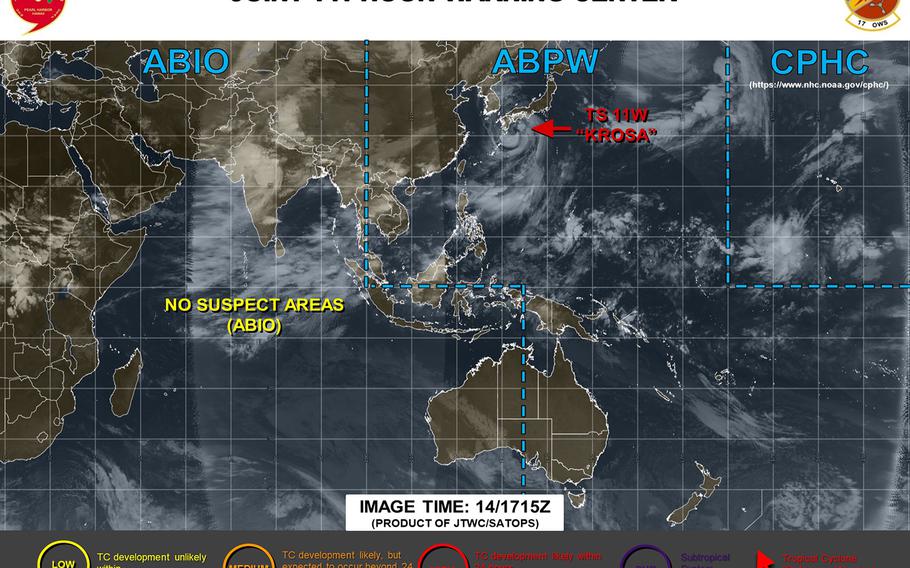
5:45 a.m. Tuesday, Aug. 13, Japan time: The news continues to get slightly better with every forecast-track update for Marine Corps Air Station Iwakuni regarding Tropical Storm Krosa. The latest Joint Typhoon Warning Center forecast track takes Krosa even further east of Iwakuni — not much more, but a little more — and there's every chance now that Krosa might not intensify into a typhoon after all, unlike previous reports. At 5:30 a.m., Krosa was 545 miles south-southeast of Iwakuni, moving north-northwest at 15 mph and had slightly weakened, to 58-mph sustained winds and 75-mph gusts. Krosa's forecast wind field remains vast, about 450 miles when Krosa reaches land, but Iwakuni now rests at the west edges of Krosa's forecast 50-knot (58-mph) wind bands, and Sasebo Naval Base even further from it. If Krosa remains on its present heading, it's forecast to keep heading northwest until early Thursday morning, when it's due to curve northeast and make landfall over Tosashimizu on Shikoku's southwest coast about 6 a.m. Thursday. Krosa is forecast to pass nearly 200 miles east of Fleet Activities Sasebo at 7 a.m. Thursday and 59 miles east of MCAS Iwakuni at about noon. From there, it's back out over water, into the Sea of Japan, headed in the general direction of Sakhalin Island in eastern Russia. This post will be updated at about mid-day Tuesday.11:45 p.m. Monday, Aug. 12, Japan time: Won't say just yet that Marine Corps Air Station Iwakuni has bought a break. But there is a bit of a silver lining to the Joint Typhoon Warning Center's latest forecast track for Tropical Storm Krosa. Instead of a near-direct hit on the base, as previously reported, JTWC now projects Krosa to pass a tad further east of MCAS Iwakuni. Not much, but a bit. And that's slightly better news for the base. A northwest Pacific tropical cyclone's eastern quadrants are usually the worst of the four. By passing east of Iwakuni, the base gets exposed more to the weaker west quadrants. But it's still going to be a nasty, gusty, showery Thursday afternoon. Weather aware, be prepared. MCAS Iwakuni remains in Tropical Cyclone Condition of Readiness 4; that could be upgraded around mid-day Tuesday. At 11:30 p.m., Krosa was 633 miles south-southeast of MCAS Iwakuni, moving northwest at 12 mph and holding steady at 63-mph sustained winds and 81-mph gusts. Tropical storm-force winds extend 270 miles from Krosa's center, according to the National Weather Service on Guam. Still a fairly wide wind field, about 540 miles in diameter. JTWC projects Krosa to peak at 75-mph sustained winds and 92-mph gusts, Category 1-equivalent intensity, at mid-evening Wednesday. Still quite a wicked punch. Krosa is forecast to make landfall just west of Tosashimizu, on Shikoku Island south of Iwakuni, at mid-morning Thursday. Krosa is forecast to pass 177 miles east of Sasebo Naval Base at 10 a.m. Thursday, then 41 miles east of MCAS Iwakuni five hours later. From there, Krosa makes its way back over water, in the Sea of Japan, in the general direction of Hokkaido in northern Japan and Sakhalin Island in eastern Russia. This post will be updated at mid-day Tuesday and again if/when an accelerated TCCOR is issued for MCAS Iwakuni.5:30 p.m. Monday, Aug. 12, Japan time: The news gets a teeny bit better for Fleet Activities Sasebo: Tropical Storm Krosa's wind field remains rather vast, but Sasebo falls no longer within Krosa's forecast 50-knot (58-mph) wind bands, according to the Joint Typhoon Warning Center's latest forecast track. The same cannot be said for Marine Corps Air Station Iwakuni, which remains in Krosa's sights for a possible near-direct hit late Thursday afternoon. MCAS Iwakuni remains in Tropical Cyclone Condition of Readiness 4. At 5 p.m., Krosa was 690 miles south-southeast of MCAS Iwakuni, moving northwest at 7 mph, holding steady at 63-mph sustained winds and 81-mph gusts. Tropical storm-force winds extend 280 miles from center, according to the National Weather Service on Guam; that makes for a wind diameter of 560 miles. If Krosa stays on its present heading, it's due to keep going northwest for two more days, peaking at 75-mph sustained winds and 92-mph gusts at mid-afternoon Wednesday. JTWC next projects Krosa to curve north, skimming Kyushu's east coast, then passing 122 miles east of Sasebo at noon Thursday and 10 miles west of MCAS Iwakuni five hours later, packing 69-mph sustained winds and 86-mph gusts as it moves inland over southwestern Honshu. From there, Krosa is due to push back over water into the Sea of Japan, stay between Honshu and the Korean peninsula, then dying out near Russian's Sakhalin Island north of Hokkaido.Th This post will be updated about mid-day Tuesday, and again if/once TCCOR 3 is issued by command at MCAS Iwakuni.Noon Monday, Aug. 12, Japan time: Little change, if any, regarding Tropical Storm Krosa, which remains on course for passage just west of Marine Corps Air Station Iwakuni at mid-afternoon Thursday, according to the Joint Typhoon Warning Center. At 9 a.m., Krosa was 764 miles south-southeast of Iwakuni, moving west-northwest at 9 mph and holding steady at 63-mph sustained winds and 81-mph gusts at center. Krosa also continues to boast a massive wind field. Tropical storm-force winds extend 290 miles east and 245 miles west of center, according to the National Weather Service on Guam. JTWC projects Krosa to remain a severe tropical storm for another day or so, then curve north and northeast, peaking at 75-mph sustained winds and 92-mph gusts, Category 1-equivalent typhoon-strength, as it makes landfall at Nobeoka on Kyushu's east coast at mid-morning Thursday. That's just south of MCAS Iwakuni; Krosa is forecast to pass 17 miles west at 3 p.m., six hours after landfall and 121 miles east of Sasebo Naval Base at 10 a.m. Iwakuni remains in Tropical Cyclone Condition of Readiness 4. Sasebo has not set a TCCOR at this point. Once done with Iwakuni, Krosa is forecast to push back over water into the Sea of Japan and split the difference between the Korean peninsula and the west coast of Honshu, well away from any U.S. bases in either locale. This post will be updated sometime Monday evening.6 a.m. Monday, Aug. 12, Japan time: After sitting practically idle for a couple of days, Tropical Storm Krosa is now on a consistent northwest course, putting Marine Corps Air Station Iwakuni in its sights for a forecast rendezvous later this week, according to the Joint Typhoon Warning Center. At 3 a.m., Krosa was 818 miles south-southeast of Iwakuni, headed northwest at 7 mph and holding steady at 63-mph sustained winds and 81-mph gusts. Tropical storm-force winds extend 275 miles northeast and 225 miles elsewhere from center, according to the National Weather Service on Guam. That’s quite a wide wind field. Wide enough that Fleet Activities Sasebo could feel some of effects from the edges of Krosa’s forecast 50-knot (58-mph) wind bands. Krosa is forecast to intensify back to Category 1-equivalent typhoon strength before making landfall early Thursday. For the moment, MCAS Iwakuni remains in Tropical Cyclone Condition of Readiness 4; no TCCORs have been directed yet by CFAS. If Krosa continues on its present heading, it’s forecast to pass 116 miles east of Sasebo at 11 a.m. Thursday, and 17 miles west of Iwakuni five hours later, packing 81-mph sustained winds and 98-mph gusts as it roars through southwestern Honshu and eastern Kyushu. There continues to be something of a spread in model track guidance, while the GFS and CMC ensembles are in agreement on a track through Iwakuni, with some outliers. This post will be updated sometime Monday afternoon and evening.6:15 p.m. Sunday, Aug. 11, Japan time: Tropical Storm Krosa has weakened slightly, but remains on course to pass just east of Marine Corps Air Station Iwakuni on Thursday afternoon as a powerful tropical storm, according to the Joint Typhoon Warning Center. At 5:30 p.m., Krosa was 850 miles southeast of Iwakuni, moving west-northwest at 8 mph and was packing 63-mph sustained winds and 81-mph gusts. Tropical Storm-force winds extend 245 miles from storm's center, according to the National Weather Service on Guam. If Krosa remains on its present heading, it's forecast to arc north in the coming days and pass 30 miles east of Iwakuni at 5 p.m. Thursday, packing 69-mph sustained winds and 86-mph gusts, just below typhoon strength. MCAS Iwakuni remains in Tropical Cyclone Condition of Readiness 4. JTWC projects Iwakuni to be within Krosa's destructive 58-mph wind field. Not so much Sasebo Naval Base; Krosa is forecast to pass 165 miles east of Sasebo at noon Thursday, which should buy Fleet Activities Sasebo something of a break.Model track guidance and the GFS and CMC ensembles are in better agreeement on a forecast track toward Iwakuni, with about a 300-mile spread among model solutions, according to JTWC. This post will be updated early Monday morning.2:30 p.m. Sunday, Aug. 11, Japan time: Marine Corps Air Station Iwakuni has entered Tropical Cyclone Condition of Readiness 4 as of 2 p.m. Sunday. Destructive winds of 58 mph or greater are possible within 72 hours. Joint Typhoon Warning Center projects Tropical Storm Krosa to pass 14 miles east of Iwakuni at 4 p.m. Thursday, packing 75-mph sustained winds and 92-mph gusts.12:15 p.m. Sunday, Aug. 11, Japan time: Krosa is holding steady at just below typhoon intensity, 69-mph sustained winds and 86-mph gusts, and continues to move very slowly well south of Japan's main islands. Southwestern Japan remains the prime target, if the Joint Typhoon Warning Center's latest forecast track holds, with Marine Corps Air Station Iwakuni nearly in the crosshairs and even Sasebo Naval Base could feel some of Krosa's effects. JTWC's closest-point-of-approach pendulum regarding Okinawa has swung back to the right, further east of the island. Tuesday evening and Wednesday morning could be showery and gusty, but only hinting at what Lekima provided last week. At 9 a.m., Krosa was 915 miles southeast of Iwakuni, crawling northwest at 6 mph. Its wind field remains vast; tropical storm-force winds extend 260 miles northeast and 225 miles elsewhere from center, according to the National Weather Service on Guam. If Krosa remains on its present heading, it's due to travel roughly northwest for the next three days, starting to curve north toward Iwakuni at mid-day Wednesday. Krosa is forecast to pass 363 miles northeast of Kadena Air Base at 9 a.m. Wednesday, and intensifying to 81-mph sustained winds and 98-mph gusts. But that's at storm's center.Kadena's long-range forecast calls for showers and isolated thunderstorms Tuesday evening and Wednesday morning with westerly 28-mph sustained winds and gusts up to 42 mph. From there, JTWC projects Krosa to turn poleward, forecast to pass 14 miles east of Iwakuni at 4 p.m. Thursday, still packing 75-mph sustained winds and 92-mph gusts, Category 1-equivalent intensity. Krosa is due to pass 151 miles east of Sasebo at 11 a.m. Thursday.Model track guidance, the GFS and CMC forecast ensembles are in a bit better agreement on a track toward Iwakuni, with NAVGEM and the CMC ensemble still favoring a sharper northeast curve in the long term. Much can still change. All of the above is three to four days out. All bases for the moment remain in their seasonal Tropical Cyclone Conditions of Readiness. Stay tuned.11:40 p.m. Saturday, Aug. 10, Japan time: Krosa has been downgraded to a tropical storm by the Joint Typhoon Warning Center. It's been quasi-stationary the last six hours, and is forecast to weaken further still, remain out of range of Okinawa and still put Marine Corps Air Station Iwakuni in its sights. At 11:20 p.m., Krosa was 920 miles southeast of Iwakuni, crawling west-southwest at 3 mph and had diminished to 69-mph sustained winds and 86-mph gusts. Krosa's remains a vast wind field. Typhoon-force winds extend 85 miles from storm's center and tropical storm-force winds 275, reports the National Weather Service on Guam. If Krosa stays on its current heading, Kosra is due to resume a northwest heading soon. It's forecast to weaken to 63-mph sustained winds and 81-mph gusts, intensifying slightly as it heads to the coasts of Honshu and Shikoku islands in west-central Japan. Krosa is now forecast to pass 324 miles east-northeast of Kadena Air Base at 7 a.m. Wednesday, about which time it regains Category 1-equivalent intensity. But well out of Okinawa's range. Close enough for gusts and showers similar to what Lekima brought earlier this week. JTWC then projects Krosa to curve north, weakening again to severe tropical-storm status as it passes 21 miles east of Iwakuni at 7 p.m. Thursday, packing 69-mph sustained winds and 86-mph gusts.Model track guidance and the GFS forecast ensemble each mirror the JTWC forecast track, while the CMC ensemble continues to favor a sharper northeast turn.Stay tuned. This post will be updated at mid-morning Sunday and again just past noon.5:30 p.m. Saturday, Aug. 10, Japan time: Typhoon Krosa has curved westbound, is starting to pick up forward speed and is forecast to bypass Okinawa, curving north on Wednesday and putting Marine Corps Air Station Iwakuni in its crosshairs for a Thursday afternoon rendezvous. At 5 p.m., Krosa was 922 miles southeast of Iwakuni, moving northwest at 6 mph and had weakened slightly, to 75-mph sustained winds and 92-mph gusts at center. But Krosa features a rather vast wind field; typhoon-force winds extend 70 miles from center and tropical storm-force winds 255, according to the National Weather Service on Guam. Krosa remains forecast to bypass the island, 331 miles east-northeast of Kadena Air Base at 6 a.m. Wednesday, packing 81-mph sustained winds and 98-mph gusts at storm's center. The good news for Okinawa: Since it's forecast to pass east of the island, Krosa's western quadrants, the weaker of the four, would be facing Okinawa if its current track holds. The not-so-good news for Okinawa: Krosa's wind diameter could stretch as much as 500 miles, meaning Okinawa's east coast and northern sections could see some gusty winds and showers. Not destructive or damaging winds -- at least not yet -- but similar to what Okinawa experienced earlier this week from Lekima. It's a question of whether Krosa's forecast track comes any closer to the island. If Krosa remains on its present heading, it's forecast to curve north at mid-afternoon Tuesday, then make a beeline for Iwakuni and a forecast pass of 14 miles east at 3 p.m. Thursday, still packing 75-mph sustained winds and 92-mph gusts. That's quite a way's away, though. A lot can change in that span. Much has changed already; Krosa's forecast track has shifted 90 miles west, closer to Okinawa, in the last day. It could push further west; it could reverse course. One never knows.Model track guidance, mainly the GFS track, mirrors that of JTWC, with variations. GEM favors a course for Tokyo and NAVGEM closer to Sasebo Naval Base. So, too, does the GFS forecast ensemble resemble the JWTC track but with outliers; the CMC ensemble is starting to come into better agreement, but with a more sharp northeast curve. Short answer remains: The only thing certain is uncertainty. All U.S. bases remain in seasonal Tropical Cyclone Conditions of Readiness. Stay tuned. Nothing's definite yet.Noon Saturday, Aug. 10, Japan time: Marine Corps Air Station Iwakuni might get a rainy, gusty visitor next Thursday evening, if Typhoon Krosa keeps moving along its current Joint Typhoon Warning Center forecast track. At 9 a.m., Krosa was 952 miles southeast of MCAS Iwakuni, crawling north at 3 mph packing 81-mph sustained winds and 98-mph gusts at center. Typhoon-force winds extend 70 miles from center and tropical storm-force winds 275 miles, according to the National Weather Service on Guam. Krosa is semi-sort of on the move again, and is forecast to curve northwest and finally pick up forward speed as it heads in southwestern Japan's general direction. For the moment, Krosa is something for Okinawa to keep its eyes on, but not a major concern. Krosa is forecast to pass 385 miles east-northeast of Kadena Air Base at 5 a.m. Wednesday. It's forecast to feature a rather wide wind field, but not nearly as powerful as Lekima before it. And the left-side quadrants, generally the weaker ones, would affect Okinawa, if at all. But yes, this is weather. And the more Krosa might move closer to the island, the more of a concern it might be. Krosa is forecast to start curving poleward at mid-morning Tuesday. By the end of the JTWC forecast period, Krosa would be 163 miles south-southeast of Iwakuni at mid-morning Thursday.Model track guidance somewhat mirrors the JTWC forecast track. as does the GFS forecast ensemble with plenty of outliers. The CMC forecast ensemble favors a track more to the east, in Tokyo's general direction, also with scads of outliers. And for the moment, all U.S. bases remain in their seasonal Tropical Cyclone Conditions of Readiness. Stay tuned. A lot can change over a day or four.1 a.m. Saturday, Aug. 10, Guam time: Typhoon Krosa continues to weaken gradually, but still holding onto Category 2-equivalent status. It's begun turning north after sitting quasi-stationary for more than a day, according to the Joint Typhoon Warning Center. Questions linger over Krosa's long-term track. JTWC's latest forecast track edges Krosa a bit closer to Okinawa than previously reported, but the island still remains well out of danger for the moment. It's Honshu that's in Krosa's crosshairs. But where in Honshu? That's the $64,000 question. At 12:45 a.m., Krosa was 917 miles south of Yokosuka Naval Base, crawling northeast at 4 mph, packing 98-mph sustained winds and 121-mph gusts. Typhoon-force winds extend 85 miles from center and tropical storm-force winds 295 miles, according to the National Weather Service on Guam. If Krosa remains on its present heading, it's forecast to curve northwest and keep going in that direction for about three days, weakening gradually as it goes, passing 375 miles east-northeast of Kadena Air Base at 2 a.m. Wednesday. Krosa is then due to turn north. Where exactly it goes? Hard to say. Model track guidance takes aim at Nagoya in central Japan. The GFS forecast ensemble's best track suggests Osaka-Kansai and the CMC ensemble favors the Tokyo area, with outliers on both sides. Short answer: The only thing certain is uncertainty. Stay tuned. This post will be updated at 1 p.m. Guam time, sooner if needed.1:15 p.m. Friday, Aug. 9, Guam time: Krosa has weakened from Category 3- to Category 2-equivalent typhoon status in very short order as it remains far from any land mass, according to the Joint Typhoon Warning Center. At 1 p.m., Krosa was 944 miles south of Yokosuka Naval Base, sitting quasi-stationary and packing 104-mph sustained winds and 127-mph gusts at center. Typhoon-force winds extend 75 miles from center and tropical storm-force winds 255 miles south and 225 miles north, according to the National Weather Service on Guam. If Krosa remains on its present heading, it's forecast to turn north, then northwest, keeping Okinawa well out of range; it's forecast to pass 420 miles east of Kadena Air Base at 9 p.m. local time Tuesday before turning north again. Where it heads from there is open to question. Krosa is forecast to maintain between Categories 1 and 2 intensity. The GFS and CMC ensembles depict northeast tracks at differing times, but with plenty of outliers, one or two in Okinawa's general direction, but not that close. It's wait-and-see for Okinawa, again, after Lekima missed the island by more than 200 miles southwest. And also for central Japan; might Krosa venture toward Iwakuni or Tokyo? Hard to say right now. Stay tuned.7:30 p.m. Thursday, Aug. 8, Guam time: Another. Just like the other. Krosa appears to be trying to mirror its neighbor to the west, Super Typhoon Lekima, and has mushroomed rapidly into Category 3-equivalent strength, according to the Joint Typhoon Warning Center. At 7:15 p.m., Krosa was 945 miles south of Yokosuka Naval Base, sitting quasi-stationary and packing 115-mph sustained winds and 144-mph gusts. Typhoon-force winds extend 60 miles and tropical storm-force winds 220 miles from center, according to the National Weather Service on Guam. JTWC projects that to be Krosa's peak intensity, before it resumes its journey north in the general direction of Japan.7:30 a.m. Thursday, Aug. 8, Guam time: Krosa has been upgraded to a Category 1-equivalent typhoon by the Joint Typhoon Warning Center, and remains on course to zig-zag north, peaking as a Category 2-equivalent storm while still well out at sea. At 7:15 a.m., Krosa was 959 miles south of Yokosuka Naval Base, moving north-northwest at 5 mph, packing 81-mph sustained winds and 98-mph gusts at center. Tropical storm-force winds extend 220 miles from center, according to the National Weather Service on Guam. If it remains on its present heading, Krosa is forecast to keep moving generally north, peaking at 98-mph sustained winds and 121-mph gusts at 4 a.m. Saturday, then gradually subsiding as it keeps moving north. Both the GFS and CMC ensembles have it curving northeast before reaching land, with some outliers.1:30 p.m. Wednesday, Aug. 7, Guam time: Tropical Storm Krosa continues a wig-wag course northbound, strengthening as it goes, now up to 63-mph sustained winds and 81-mph gusts. Though long-term forecast tracks show it curving away from Japan's main islands and not making landfall, the Joint Typhoon Warning Center's latest forecast graphic shows a massive wind field, the 40-mph wind-bands radius stretching as much as 400 miles. Hence, why though Krosa is forecast to pass 410 miles south-southeast of Yokosuka Naval Base at noon Monday, it could be a gusty, showery day in the Kanto Plain. Stay tuned. At 10 a.m., Krosa was 512 miles north-northwest of Guam, headed northwest at 9 mph, packing 63-mph sustained winds and 81-mph gusts. Tropical storm-force winds extend almost 200 miles from center, according to the National Weather Service.10 p.m. Tuesday, Aug. 6, Guam time: Krosa was upgraded rather quickly to a tropical storm by the Joint Typhoon Warning Center. Krosa is Cambodian for crane. At 7 p.m., Krosa was 400 miles north-northwest of Guam and was heading northwest at 10 mph, packing 46-mph sustained winds and 58-mph gusts at center. JTWC projects to peak at 86-mph sustained winds and 104-mph gusts Thursday afternoon as it zig-zags north.7 a.m. Tuesday, Aug. 6, Guam time: Tropical Depression 11W formed overnight north of Guam and is forecast to peak as at Category 1 typhoon early Friday morning and remain well out at sea, at least for now. At 6:45 a.m., 11W was 275 miles north of Guam, headed west at 6 mph with 29-mph sustained winds and 40 mph gusts. 11W is forecast to turn north, peaking at 81-mph sustained winds and 98-mph gusts early Friday morning, then gradually weaken as it crosses the Tropic of Cancer.11 p.m. Monday, Aug. 5, Japan time: Wow, traffic is really picking up on Typhoon Highway in the Pacific. A tropical cyclone formation alert has been issued on a system labeled 95W Invest, currently 325 miles north of Andersen Air Force Base, Guam, and headed northwest at 7 mph.
Unlike Tropical Storm Lekima, model track guidance and the GFS and CMC forecast ensembles are in relatively good agreement that 95W first will track generally poleward, then will curve northeast and pass a good distance southeast of the Tokyo area. Stay tuned.
