()
()
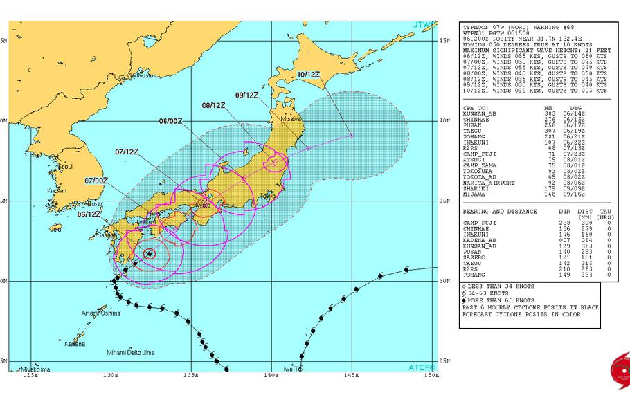
Noru downgraded to tropical depression, making wide circle well north and east Tokyo. (www.NOAA.gov)
2 p.m. Wednesday, Aug. 9, Japan time: Credit Super Typhoon Noru with a silver medal. For Noru, which formed on July 18 northeast of the Wake atoll, dissipated this week as the second longest-enduring tropical cyclone in northwest Pacific history since they began keeping records in 1951. Noru lasted 18 days and 18 hours, according to Digital Typhoon. That's second only to Rita, a super typhoon which endured for 19 days in July 1972. Noru first appeared as a low-pressure area 435 miles northeast of Wake, unusual for such a high latitude, at mid-day July 18, The Joint Typhoon Warning Center issued a tropical cyclone formation alert on Noru on July 20, upgraded it to a tropical storm on July 21, then to the first typhoon of the northwest Pacific season late on July 23. It eventually became the first super typhoon of the season. Early in its life span, Noru engaged in what's called a Fujiwhara Effect, when two tropical cyclones collide, with Noru and Tropical Storm Kulap doing a song and dance around each other and Noru completing a long, slow, wide circle well away from land. Once that was done, Noru rapidly intensified starting July 30 from a severe tropical storm to a super typhoon within a one-day span, Noru turned west, away from Iwo Jima, and U.S. bases on Okinawa briefly went to Tropical Cyclone Condition of Readiness 3 as it appeared headed in the island's direction. Noru then curved north and northeast, losing its punch as it brushed the south coast of Kyushu and Shikoku in southwestern Japan, finally making landfall over Wakayama Prefecture in the Kansai region. Over the mountains of central Honshu and out into the Sea of Japan it went before dying out south of Misawa Air Base late Tuesday. So, Rita still stands as the longest enduring cyclone in the northwest Pacific and Noru stands alone in second. But Rita still pales compared to Super Typhoon John of 1994, which remains the longest-enduring tropical cyclone in Pacific history. John formed southwest of Guatemala in early August, then traveled 7,165 miles from the eastern Pacific to the western Pacific and back to the central Pacific over a 31-day span. A total of 120 warnings were issued for John by three agencies, the National Hurricane Center, the Central Pacific Hurricane Center and JTWC.6 p.m. Tuesday, Aug. 8, Japan time: Tropical Depression Noru has wandered out into the Sea of Japan, just over Sado Island, and is due to curve back over northern Honshu just south of Misawa Air Base, according to the Joint Typhoon Warning Center. At 3 p.m., Noru was 173 miles north-northwest of Yokota Air Base, drifting northeast at 9 mph with 35-mph sustained winds and 46-mph gusts. Most models show Noru curving back out into the Pacific Ocean and dying out at those northern latitudes. Noru has survived almost 18 1/2 days, tied for the second-longest enduring northwestern Pacific tropical cyclone since records began being kept in 1951. According to Digital Typhoon, Noru has surpassed Typhoon Opal of 1967. If Noru survives until noon Wednesday, it ties Typhoon Rita of 1972 at 19 days. The longest living storm on record was Typhoon John in 1994, which began off the southwest Guatemala coast and survived for 31 days.8:30 a.m. Tuesday, Aug. 8, Japan time: Good news all around. In short order, Noru has been downgraded to a tropical depression and is making kind of a wide circle north and east, further away from Tokyo than earlier forecast, according to the Joint Typhoon Warning Center.
At 3 a.m., Noru was 115 miles west-northwest of Camp Fuji, moving north-northeast at 14 mph and has diminished to 35-mph sustained winds and 46-mph gusts at center. Noru is forecast to gradually diminish as it passes through northern Honshu. Closest points of approach to U.S. bases in the Kanto Plain have come and gone. PST will keep watch to see if anything changes.
11:30 p.m. Monday, Aug. 7, Japan time: Finally. After more than two weeks as a typhoon, the strongest one of the northwest Pacific tropical cyclone season, Noru has been downgraded to a tropical storm by the Joint Typhoon Warning Center. It continues heading northeast and is forecast to pass north of Tokyo before exiting into the Pacific Ocean – again – and die out as a tropical depression.
At 9 p.m., Noru was 128 miles west-southwest of Camp Fuji, racing northeast at 18 mph with 63-mph sustained winds and 81-mph gusts at center. Noru is forecast to deteriorate as it interacts with the mountains over central Honshu as it hurtles northeast.
Noru is forecast to pass 52 miles northwest of Yokota Air Base, 55 miles north-northwest of Camp Fuji, 62 miles northwest of Camp Zama and Naval Air Facility Atsugi and 84 miles northwest of Yokosuka Naval Base between 9 and 10 a.m. Tuesday, still a tropical storm, 40-mph sustained winds and 52-mph gusts as it roars past.
Noru made landfall over Wakayama Prefecture south of Osaka about 3:30 p.m. Two people were killed, each elderly men, one on Yakushima island and another on neighboring Tanegashima island, some 17 people were injured and more than 400 flights were canceled, Japan national broadcaster NHK said via the Straits Times of Singapore.
8:30 a.m. Tuesday, Aug. 8, Japan time: Good news all around. In short order, Noru has been downgraded to a tropical depression and is making kind of a wide circle north and east, further away from Tokyo than earlier forecast, according to the Joint Typhoon Warning Center.
At 3 a.m., Noru was 115 miles west-northwest of Camp Fuji, moving north-northeast at 14 mph and has diminished to 35-mph sustained winds and 46-mph gusts at center. Noru is forecast to gradually diminish as it passes through northern Honshu. Closest points of approach to U.S. bases in the Kanto Plain have come and gone. PST will keep watch to see if anything changes.
9:45 a.m. Monday, Aug. 7, Japan time: Noru continues to cling to Category 1-equivalent typhoon status, is making its way past Marine Corps Air Station Iwakuni and remains on course to pass north of the Tokyo area on Tuesday, bringing some gusts and showers, some heavy at times, as it rolls by.
At 3 a.m., Noru was 141 miles south-southeast of Iwakuni, heading northeast at 10 mph, continuing to hold steady at 75-mph sustained winds and 92-mph gusts at center. Iwakuni remains in Tropical Cyclone Condition of Readiness Storm Watch. Forecasts call for showers and gusty winds with rapid clearing behind it as Noru continues northeast.
If Noru remains on its current path, it’s due to pass just south of Osaka, north of Nagoya and through the central mountains of Honshu. It should pass 51 miles north-northwest of Yokota Air Base, 66 miles north-northwest of Camp Fuji, 63 miles north-northwest of Camp Fuji and Naval Air Facility Atsugi and 83 miles north-northwest of Yokosuka Naval Base between noon and 6 p.m. Tuesday.
Noru is forecast to continue packing 46-mph sustained winds and 58-mph gusts at center as it passes the Kanto Plain. No TCCORs have been issued at this point. There’s every chance Storm Watch may be issued at some locales. Forecasts call for gusty winds, rain and showers, heavy at times, as Noru passes.
Midnight Sunday, Aug. 6, Japan time: Closer, ever closer to Tokyo … Typhoon Noru continues picking up forward speed and rolling northeast, but the forecast track keeps edging east, and while Noru should degrade to a tropical storm, the Kanto Plain could be in for a gusty, showery Tuesday if the Joint Typhoon Warning Center track holds.
At 9 p.m., Noru continued clinging to Category 1-equivalent typhoon status, 181 miles south of Marine Corps Air Station Iwakuni, rumbling northeast at 12 mph with 75-mph sustained winds and 92-mph gusts at center.
If it stays on its current path, Noru is due to pass 123 miles southeast of Iwakuni at 7 a.m. Monday as a severe tropical storm, 69-mph sustained winds and 86-mph gusts at center. But Iwakuni should remain out of Noru’s 50-knot wind bands if the track holds.
Noru has made its closest point of approach to Sasebo Naval Base, which reverted to Tropical Cyclone Condition of Readiness All Clear at 8:30 p.m. Iwakuni remains in TCCOR Storm Watch.
No accelerated TCCORs have been issued yet at Kanto Plain bases, which should get a good dusting from Noru’s east quadrants as a middling tropical storm, 46-mph sustained winds and 58-mph gusts at center.
Noru is due to pass 75 miles northwest of Yokota Air Base, 82 miles northwest of Camp Fuji, 86 miles northwest of Camp Zama and Naval Air Facility Atsugi and 107 miles northwest of Yokosuka Naval Base between 10 and 11 a.m. Tuesday.
6:15 p.m. Sunday, Aug. 6, Japan time: Typhoon Noru's forecast track continues edging further east of Sasebo Naval Base and Marine Corps Air Station Iwakuni, and getting ever closer to the Tokyo-Kanto Plain area, according to the Joint Typhoon Warning Center.
At 3 p.m., Noru was 174 miles southeast of Sasebo, tracking northeast at 8 mph, holding steady at 75-mph sustained winds and 92-mph gusts at center.
If Noru remains on its current path, it's due to pass 169 miles southeast of Sasebo at 7 p.m., then 116 miles southeast of Iwakuni 11 hours later, still clutching onto Category 1-equivalent typhoon status. Both bases remain in Tropical Cyclone Condition of Readiness Storm Watch.
While that may be better news for Sasebo and Iwakuni, bases in the Tokyo-Kanto Plain area might begin casting a wary eye on what's left of Noru as it speeds northeast, interacting with land along the way.
Modelguidance shows Noru heading over central Honshu, rapidly losing its punch, but coming close enough to U.S. bases to make for a gusty, showery start of the week.
Noru is forecast to pass 101 miles northwest of Yokota Air Base, 105 northwest of Camp Fuji, 112 miles northwest of Naval Air Facility Atsugi and Camp Zama and 133 northwest of Yokosuka Naval Base between 11 a.m. and 3 p.m. Tuesday. Noru should then exit into the Pacific Ocean south of Misawa Air Base.
That whole scenario could change. Please stay tuned.
2 p.m. Sunday, Aug. 6, Japan time: Here we go again, with two possible destinations for Typhoon Noru. Where will it end up, the Pacific Ocean or the Sea of Japan? And will Tokyo feel some of its effects?
At 9 a.m. according to the Joint Typhoon Warning Center, Noru was 179 miles south-southeast of Sasebo Naval Base, starting to pick up forward speed, heading northeast at 8 mph, holding steady at 75-mph sustained winds and 92-mph gusts at center.
Sasebo and perhaps Marine Corps Air Station Iwakuni might be spared Noru's full fury. Noru is due to pass 161 miles southeast of Sasebo at 7 p.m. and 93 miles southeast of Iwakuni 12 hours later. Both bases remain in Tropical Cyclone Condtiion of Readiness Storm Watch and appear to be well outside Noru's 50-knot wind bands, if the JTWC track holds.
But will it?
Model guidance is showing two possible tracks for Noru. JTWC's latest report (paragraph 2, section C) states some models depict Noru tracking over central Honshu into the Sea of Japan, while others show Noru turning east toward the Tokyo-Kanto Plain area, bringing gale-force winds to the area. No TCCORs have been set there yet.
Stay tuned.
9:15 a.m. Sunday, Aug. 6, Japan time: Sasebo Naval Base and Marine Corps Air Station Iwakuni might catch a break from Typhoon Noru, if the current Joint Typhoon Warning Center forecast track holds.
At 3 a.m., Noru was just barely hanging on to Category 1-equivalent typhoon status, 205 miles south-southeast of Sasebo, crawling northeast at 4 mph, with 75-mph sustained winds and 92-mph gusts at center.
Noru is forecast to pick up forward speed, start tracking rapidly northeast, passing 166 miles southeast of Sasebo at 9 p.m. Sunday. Sasebo now appears well outside of Noru’s projected 50-knot wind bands. Fleet Activities Sasebo reverted to Tropical Cyclone Condition of Readiness Storm Watch at 8:06 a.m.
Iwakuni entered TCCOR Storm Watch at 11 a.m. Japan time and also sits outside of Noru’s forecast 50-knot wind bands. Noru is due to pass 99 miles southeast of Iwakuni at 10 a.m. Monday as a severe tropical storm, 63-mph sustained winds and 81-mph gusts at center.
Midnight Saturday, Aug. 5, Japan time: A bit of a hiccough in Typhoon Noru’s track; it made a sudden turn and headed briefly toward the southwest. But according to the Joint Typhoon Warning Center, Noru is forecast to turn back to the northeast, and head a bit further east of Sasebo Naval Base and Marine Corps Air Station Iwakuni than previously reported.
At 9 p.m., Noru was 221 miles south of Sasebo, headed west-southwest at 5 mph and had diminished slightly, 86-mph sustained winds and 104-mph gusts at center. If it remains on its forecast track, Noru is due to make a quick about-face and resume a northeasterly path.
Noru is now due to pass 136 miles southeast of Sasebo at 1 a.m. Monday, still as a Category 1-equivalent typhoon, 75-mph sustained winds and 92-mph gusts at center. And Sasebo might end up well outside Noru’s projected 50-knot wind bands. Fleet Activities Sasebo remains in Tropical Cyclone Condition of Readiness 2; TCCOR 1 is expected to be issued at 9 a.m. Sunday, depending on Noru’s track.
Iwakuni remains next on the itinerary; Noru is due to pass 68 miles southeast at 2 p.m. Monday as a severe tropical storm, 58-mph sustained winds and 75-mph gusts, but at storm’s center. Which Iwakuni might end up avoiding, again pending any changes to Noru’s track. Iwakuni remains in TCCOR 3, with TCCOR 2 expected to be issued at 9 a.m. Sunday. Stay tuned.
6 p.m. Saturday, Aug. 5, Japan time: It appears as if Typhoon Noru has reached peak intensity at 92-mph sustained winds and 115-mph gusts, according to the latest from the Joint Typhoon Warning Center.
Noru's forecast track has edged further east, which could be good news for Sasebo Naval Base and Marine Corps Air Station Iwakuni. U.S. bases on Okinawa have reverted to seasonal Tropical Cyclone Condition of Readiness 4.
At 3 p.m., Noru was 216 miles south of Sasebo, crawling north at 5 mph. If it remains on its present course, Noru is due to curve northeast, passing 122 miles southeast of Sasebo at 9 p.m. Sunday, clinging to Category 1-equivalent typhoon strength, 74-mph sustained winds and 92-mph gusts at center.
JTWC projects Sasebo to be outside Noru's 50-knot wind band. Fleet Activities Sasebo remains in TCCOR 2, with TCCOR 1 expected to be issued at 9 a.m. Sunday.
Iwakuni, which remains in TCCOR 3, could catch a break as well. Noru is forecast to pass 52 miles southeast of Iwakuni at 11 a.m. Monday, still a fierce tropical storm, 63-mph sustained winds and 81-mph gusts, but at storm's center. TCCOR 2 is expected to be issued at mid-morning Sunday.
Though forecast to skim the north coast of Japan's main Honshu island, the Kanto Plain should be well out of harm's way. JTWC projects Noru to pass 220 miles northwest of Yokota Air Base at noon Tuesday as a middling tropical storm.
10 a.m. Saturday, Aug. 5, Japan time: Marine Corps Air Station Iwakuni has entered Tropical Cyclone Condition of Readiness 3. Destructive winds of 58 mph or greater are possible within 48 hours.
Typhoon Noru has begun intensifying and could become a Category 3-equivalent storm sometime Sunday morning before forecast landfall over Kyushu’s southeastern edges at mid-day Sunday, according to the Joint Typhoon Warning Center.
At 3 a.m., Noru was 245 miles northeast of Kadena Air Base, Okinawa, had stalled somewhat, tracking northeast at only 4 mph and had strengthened to 92-mph sustained winds and 115-mph gusts. Noru is forecast to curve northeast and intensify to 115-mph sustained winds and 144-mph gusts by 3 a.m. Sunday and make landfall at noon.
If it remains on its current path, Noru should pass 116 miles southeast of Sasebo Naval Base at 11 p.m. Sunday, packing 81-mph sustained winds and 98-mph gusts at center. Fleet Activities Sasebo remains in TCCOR 2 and anticipates going to TCCOR 1 at 9 a.m. Sunday, according to its official Facebook page.
Noru is next forecast to rumble 40 miles southeast of Iwakuni, still packing 69-mph sustained winds and 86-mph gusts at center. Still a strong tropical storm.
Model guidance has come into better agreement regarding Noru’s projected track, taking it over southeastern Kyushu, but still varies beyond that. PST is keeping watch.
11 p.m. Friday, Aug. 4, Japan time: Not much change. Typhoon Noru is forecast to pass 110 miles southeast of Sasebo Naval Base at 1 a.m. Monday and 17 miles southeast of Marine Corps Air Station Iwakuni 12 hours later. Forecaste wind values for each locale are the same as reported earlier. Sasebo remains in Tropical Cyclone Condition of Readiness 2 and Iwakuni in TCCOR 4; expect the latter to upgrade to TCCOR 3 at 9 a.m. Saturday.
6 p.m. Friday, Aug. 4, Japan time: Further east, ever further east, Typhoon Noru's forecast track has edged even further away from Sasebo Naval Base than previously reported. And judging by Joint Typhoon Warning Center's latest track, it could be Marine Corps Air Station Iwakuni that ends up in the crosshairs.
At 3 p.m., Noru was 253 miles northeast of Kadena Air Base, Okinawa, headed west-northwest at 6 mph, still holding steady at 86-mph sustained winds and 104-mph gusts at center. Noru appears ready to make that sharp curve northeast and is due to peak at 104-mph sustained winds and 127-mph gusts early Saturday morning.
If Noru remains on its present course, it should pass 239 miles northeast of Kadena at 3 a.m. Saturday as it bends north. U.S. bases on Okinawa remain in Tropical Cyclone Condition of Readiness Storm Watch. Kadena's 18th Wing Weather Flight projects peak winds to be 35-mph sustained and 40-mph gusts at 3 a.m. Saturday.
Things keep looking better for Sasebo, as JTWC's track takes it over Kyushu's eastern edges, 115 miles southeast of Sasebo at 4 a.m. Monday, still packing a wicked punch, 75-mph sustained winds and 92-mph gusts as Noru makes landfall early Monday. Fleet Activities Sasebo remains in TCCOR 2.
But what makes things better for Sasebo, could make things worse for Iwakuni. As of now, Noru is due to pass 18 miles east of Iwakuni as a strong tropical storm, 63-mph sustained winds and 81-mph gusts as it rolls past. Iwakuni remains in TCCOR 4.
And questions do remain about Noru's exact path, since something of a spread remains among model guidance. GFS depicts a path east of Sasebo and close to Iwakuni, while GEM points Noru east, skimming Japan's island coastlines in Tokyo's general direction. PST has an eyeball on it.
Noon Friday, Aug. 4, Japan time: Here we go again with the spread among dynamic aids regarding Typhoon Noru.
Does it rumble over Kyushu in southwestern Japan as next week begins, as Joint Typhoon Warning Center projects? Or does it make a sharper right turn and skim the south coast of Japan's main islands, with Tokyo a possible destination? Model guidance shows a clear divergent picture.
At 9 a.m., Noru was 270 miles east-northeast of Kadena Air Base, Okinawa, tracking west at 8 mph, holding steady at 86-mph sustained winds and 104-mph gusts.
Though Okinawa appears to be well out of harm's way, gusts are picking up, especially on the island's east side; surfers could be plainly seen along the shoreline of Kin Bay, just west of Camp Courtney, at mid-morning Friday. U.S. bases on Okinawa remain in Tropical Cyclone Condition of Readiness Storm Watch.
It's Kyushu that yet appears to be Noru's most likely destination. If Noru remains on its current JTWC forecast track, it's due to pass 90 miles southeast of Sasebo Naval Base at 3 a.m. Monday as a severe tropical storm, 63-mph sustained winds and 81-mph gusts at center. But JTWC's graphic shows Sasebo outside of the forecast 50-knot wind bands. Fleet Activities Sasebo remains in TCCOR 2; that will likely be upgraded sometime early Sunday.
The forecast track does take Noru closer to Marine Corps Air Station Iwakuni than previously reported, just 10 miles northwest at 3 p.m. Monday, with strength similar to that as it passes Sasebo. Iwakuni remains in TCCOR 4; expect that to be upgraded sometime Saturday morning.
Yet now, there is that chance -- an outside one, JTWC reports -- that Noru might make a tighter turn and make its way along Honshu island's southern coast toward Tokyo by the middle of next week. Only time will tell.
11:30 a.m. Friday, Aug. 4, Japan time: Here's your updated TCCOR scoreboard for southwestern Japan as of 11:30 a.m.:
Fleet Activities Sasebo issued Tropical Cyclone Condition of Readiness 2 at 10:36 a.m. Friday. Time to prepare, if you've not already done so. Expect TCCOR 1 to be issued sometime Friday evening. Marine Corps Air Station Iwakuni directed TCCOR 4 at 9 a.m. Friday. U.S. bases on Okinawa remain in TCCOR Storm Watch.10 a.m. Friday, Aug. 4, Japan time: U.S. bases on Okinawa have been placed in Tropical Cyclone Condition of Readiness Storm Watch.
Threat of destructive winds from Typhoon Noru are not anticipated, but a state of readiness should be maintained "just in case."
7 a.m. Friday, Aug. 4, Japan time: Fairly good chance that Noru might pass by Sasebo Naval Base early Monday as a tropical storm rather than a typhoon, and a tad further away from Sasebo than previously forecast, according to the Joint Typhoon Warning Center.
At 3 a.m., Noru was 361 miles south-southeast of Sasebo, headed west at 8 mph, holding steady at 86-mph sustained winds and 104-mpgh gusts. JTWC projects Noru to keep heading west or west-northwest and peek at 104-mph sustained winds and 127-mph gusts at mid-afternoon Saturday.
From there, Noru is forecast to turn sharply north-northeast, heading toward Kyushu, but picking up rapid forward speed and lose strength as it goes, passing 72 miles east-southeast of Sasebo at 4 a.m. Monday, packing 63-mph sustained winds and 81-mph gusts but at storm’s center. If it remains on its forecast track, Sasebo may be spared Noru’s center 50-knot wind bands.
This could change slightly, though. Fleet Activities Sasebo remains in Tropical Cyclone Condition of Readiness 3.
Rapidly losing its punch as it hurtles over Kyushu, Noru is due to pass 22 miles west-northwest of Marine Corps Air Station Iwakuni at 3 p.m. Monday as a middling tropical storm. It should be in and out of the area fairly quickly. MCAS Iwakuni remains in TCCOR Storm Watch. That could change as well, depending on Noru’s track.
Midnight Thursday, Aug. 3, Japan time: Noru has diminished somewhat, but it remains a dangerous Category 1-equivalent typhoon and is forecast to intensify back to Category 2 status before making for a wild, rainy, gusty start of next week for Sasebo Naval Base and Marine Corps Air Station Iwakuni in southwestern Japan.
At 9 p.m., Typhoon Noru was 353 miles east-northeast of Kadena Air Base, Okinawa, moving west-northwest at 8 mph, and its intensity has scaled back some, 86-mph sustained winds and 104-mph gusts at center. Joint Typhoon Warning Center projects Noru ito re-strengthen, peaking at 98-mph sustained and 121-mph gusts at mid-evening Friday as it bends north-northeast with Kyushu dead in its sights.
If Noru remains on its current track, Okinawa should be well out of destructive-wind range of Noru, which is due to pass 245 miles northeast of Kadena at 4 a.m. Saturday. U.S. bases on Okinawa remain in Tropical Cyclone Condition of Readiness 3.
Same goes for Sasebo Naval Base in western Kyushu. Noru is due to pass 56 miles southeast of Sasebo at midnight Sunday, still packing 75-mph sustained winds and 92-mph gusts and Sasebo well inside JTWC’s projected 50-knot wind band. Expect Fleet Activities Sasebo to upgrade to TCCOR 2 sometime Friday afternoon or sooner and TCCOR 1 early Saturday morning.
As for Iwakuni, which remains in TCCOR Storm Watch, Noru should diminish to severe tropical storm strength, but still pass 47 miles northwest of the air station at 11 a.m. Monday, still packing 58-mph sustained winds and 75-mph gusts as it rumbles past and into the Sea of Japan. Expect Iwakuni to upgrade to TCCOR 4 by week’s end.
5:30 p.m. Thursday, Aug. 3, Japan time: Fleet Activities Okinawa has directed Tropical Cyclone Condition of Readiness 3 as of 4:10 p.m. Destructive winds of 58 mph or greater are possible within 48 hours. At 3 p.m., Typhoon Noru was 400 miles east-northeast of Kadena Air Base, Okinawa, moving northwest at 9 mph as a Category 2-equivalent storm, 98-mph sustained winds and 121-mph gusts at center, according to the Joint Typhoon Warning Center. Minor adjustments to Noru's forecast closest points of approach. Noru should miss Kadena 259 miles northeast at 6 a.m. Saturday; U.S. bases on Okinawa remain in TCCOR 3. JTWC projects Noru to pass 61 miles southeast of Sasebo at midnight Sunday as a Category 1-equivalent typhoon (81-mph sustained winds, 98-mph gusts at center), then 41 miles northwest of Marine Corps Air Station Iwakuni about 10 hours later as a severe tropical storm (69-mph sustained winds, 86-mph gusts).
11:45 a.m. Thursday, Aug. 3, Japan time: On the TCCOR scoreboard for southwestern Japan: U.S. bases on Okinawa remain in Tropical Cyclone Condition of Readiness 3, Sasebo Naval Base has entered TCCOR 4 and Marine Corps Air Station Iwakuni remains in TCCOR Storm Watch.
At 9 a.m., Typhoon Noru was 435 miles east of Kadena Air Base and has picked up forward speed, moving northwest at 12 mph, packing 104-mph sustained winds and 127-mph gusts at center.
Joint Typhoon Warning Center projects Noru to remain at that intensity for the next two days as it moves northwest, then bump slightly higher, to 110-mph sustained and 132-mph gusts as it turns sharply right and heads north-northeast toward Japan's main southwestern islands.
Noru is forecast to pass 59 miles southeast of Sasebo at 1 a.m. Monday, still packing 81-mph sustained winds and 98-mph gusts at center; the question being, will Sasebo be inside Noru's forecast 50-knot wind band. Fleet Activities Sasebo directed TCCOR 4 at 11:16 a.m.
About nine hours later, Noru should pass 39 miles northwest of Marine Corps Air Station Iwakuni as a severe tropical storm, 69-mph sustained winds and 86-mph gusts as it roars past.
From there, Noru is due to emerge back over water in the Sea of Japan as a tropical depression.
9 a.m. Thursday, Aug. 3, Japan time: U.S. bases on Okinawa have entered Tropical Cyclone Condition of Readiness 3. Destructive winds of 58 mph or greater are possible within 48 hours.
7:45 a.m. Thursday, Aug. 3, Japan time: Time for Sasebo Naval Base and Marine Corps Air Station Iwakuni to begin preparing for a possible visit by Typhoon Noru early next week.
Still a question of how close Noru will come to each one, but model guidance at last is in tighter agreement on such a scenario.
At 3 a.m., Noru was 561 miles southeast of Sasebo, headed north-northwest at 6 mph as a Category 2-equivalent typhoon, 110-mph sustained winds and 127-mph gusts at center.
If it remains on its current track, Noru is due to head northwest, passing 232 miles northeast of Kadena Air Base, Okinawa, at 11 a.m. Saturday, then making a sharp turn northeast toward Kyushu in southwestern Japan.
At the moment, Joint Typhoon Warning Center projects Noru to split the difference between Sasebo and Iwakuni, passing 64 miles southeast of Sasebo at 5 a.m. Monday with 81-mph sustained winds and 98-mph gusts, then 37 miles west-northwest of Iwakuni nine hours later, somewhat diminished as it interacts with land.
Some slight adjustments to that track may be in the cards as Noru approaches. But that’s the picture for the moment. More to come. Stay tuned.
Midnight Wednesday, Aug. 2, Japan time: Sasebo Naval Base remains a prime target for Typhoon Noru. But the latest Joint Typhoon Warning Center forecast track shows Noru heading just east of Sasebo, instead of slightly west, and a bit closer to Marine Corps Air Station Iwakuni than previously reported. At 9 p.m., Noru was 362 miles west-northwest of Iwo Jima and 500 miles east-northeast of Kadena Air Base, Okinawa. Forward speed has slowed considerably; Noru was heading northwest at just 4 mph, its winds holding steady at 115-mph sustained and 144-mph gusts at center, Cagetory 3-eqiuvalent strength. Noru is forecast to diminish somewhat as it continues heading northwest, but then re-intensify as it reaches warm waters just off Kyushu in southwestern Japan. JTWC projects Noru to peak at 121-mph sustained winds and 150-mph gusts as it begins curving north toward Kyushu. Forecast closest point of approach is now 19 miles southeast of Sasebo at 10 a.m. Monday, still as a Category 2-equivalent storm, 98-mph sustained winds and 115-mph gusts at center as it approaches. That's slightly better news for Korea's southeast coast. Noru is now forecast to pass 124 miles east-southeast of Chinhae Naval Base and 98 miles east-southeast of Pusan between 7 and 8 p.m. Monday. Iwakuni remains in Tropical Cyclone Condition of Readiness Storm Watch and could get more of punch from Noru than previously forecast; Noru is due to pass 90 miles northwest of Iwakuni at 8 p.m. Monday, still a Category 1-equivalent storm, 81-mph sustained winds and 98-mph gusts. Not as much of a spread any more among model guidance, but still a chance that Noru could come closer to Okinawa or turn north and east a bit sooner. It's wait and see for the moment.5:30 p.m. Wednesday, Aug. 2, Japan time: Typhoon Noru remains a Category 3-equivalent storm and continues heading northwest. The latest from the Joint Typhoon Warning Center shows a possible track early next week between Sasebo Naval Base and southeastern Korea. At 3 p.m., Noru was 345 miles west-northwest of Iwo Jima and 518 miles east-northeast of Kadena Air Base, Okinawa, moving northwest at 7 p.m. Intensity has dialed back slightly; Noru is now packing 115-mph sustained winds and 144-mph gusts at center, a tad below PST's previous report but still Category 3-equivalent strength. Should Noru remain on its current JTWC path, Noru should continue heading northwest, passing 202 miles northeast of Kadena at high noon Saturday, then arc around Kyushu, Japan's southwesternmost main island, and turning into the Tsushima Strait between Kyushu and Korea's southeastern edges. JTWC projects Noru to pass 18 miles northwest of Sasebo at 10 a.m. Monday and 87 miles south-southeast of Pusan and 100 miles south-southeast of Chinhae Naval Base, South Korea five hours later, still as a Category 1-equivalent typhoon, 81-mph sustained winds and 98-mph gusts. Marine Corps Air Station Iwakuni remains in Tropical Cyclone Condition of Readiness Storm Watch, which was issued Tuesday. U.S. bases on Okinawa remain in seasonal TCCOR 4. No TCCOR change yet at Sasebo; that could happen as early as Thursday or Friday. Model guidance has pretty much settled on a continuing west-northwest track the next two days or so followed by a turn north. When that turn occurs remains the $64,000 question. More to come.Noon Wednesday, Aug. 2, Japan time: It's pretty clear, given model guidance and Joint Typhoon Warning Center's latest update, that Typhoon Noru should keep heading northwest for the next three days or so, then turn north. The question remains: When does the turn begin? Where? Might Noru head toward Okinawa and then Sasebo Naval Base, or might the turn commence sooner, with Okinawa out of danger and Marine Corps Air Station Iwakuni in the crosshairs instead? Ah, weather. So totally unpredictable. So ... at 9 a.m., Noru was 532 miles east of Kadena Air Base, headed northwest at 6 mph and has intensified back into Category 3-equivalent status: 121-mph sustained winds and 150-mph gusts at center. Noru was a super typhoon at one time, and it appears it might approach that status again soon; blame unusually warm sea-surface temperatures for that. JTWC projects Noru to peak at 138-mph sustained winds and 167-mph gusts as it ventures close to Kyushu, in southwestern Japan, and begins curving north. Closest point of approach to Okinawa is forecast for 201 miles northeast of Kadena at 6 p.m. Saturday. For Sasebo ... it's now a mere 54 miles southwest at 9 a.m., Monday, still packing 121-mph sustained winds and 150-mph gusts. The following should sound very familiar: A vast spread remains among the model ensembles, GFS still depicting a turn north toward just east of Iwakuni, while CMC continues calling for a track right over Okinawa, then curving just shy of China's east coast to the north into the Korean peninsula. Things could get very interesting in the next day or so. Stay tuned. PST out.8 a.m. Wednesday, Aug. 2, Japan time: It’s beginning to sound like a broken record, but yes, a spread does remain among model guidance, used to determine where a typhoon might head or might not head. At this point, Sasebo Naval Base is possibly in Typhoon Noru’s crosshairs, but it could visit Okinawa first or it might curve further east, hit Central Japan and miss the two altogether.
At 3 a.m., Noru was 557 miles east of Kadena Air Base, headed northwest at 8 mph, still packing 104-mph sustained winds and 127-mph gusts at center. U.S. bases on Okinawa remain in seasonal Tropical Cyclone Condition of Readiness 4.
If Noru remains on its current Joint Typhoon Warning Center track, it’s forecast to continue northwest, strengthening and weakening to various degrees along the way. Closest point of approach to Kadena 212 miles northeast at 7 p.m. Saturday, then Noru is expected to curve north, coming within 113 miles southwest of Sasebo at 3 a.m. Monday, 110-mph sustained winds and 132-mph gusts at center.
GFS and CMC ensembles remain vastly spread, the former continuing to show a northwest track, then a sharp curve northeast, close to Marine Corps Air Station Iwakuni; and the latter a direct path toward Kadena, followed by a sharp northeast curve toward the Korean peninsula. Stay tuned. More to come.
Midnight Tuesday, Aug. 1, Japan time: Typhoon Noru weakened into a Category 2-equivalent storm as it continues heading northwest, but the Joint Typhoon Warning Center’s latest update shows Noru re-intensifying into a Category 3-equivalent typhoon just before possible landfall over southwestern Kyushu late Sunday.
At 9 p.m., Noru was 258 miles west of Iwo Jima, headed northwest at 8 mph packing 104-mph sustained winds and 127-mph gusts. If it remains on its current path, Noru should make its way into the Kyushu neighborhood by late Saturday, packing 121-mph sustained winds and 150-mph gusts.
JTWC projects Noru to keep heading northwest through Saturday, then begin curving north on Sunday. By nightfall, Noru is forecast to be 131 miles south of Sasebo Naval Base and 253 miles southwest of Marine Corps Air Station Iwakuni, packing 104-mph sustained winds and 127-mph gusts. Closest Noru is forecast to come to Okinawa is 257 miles northeast of Kadena Air Base at 7 p.m. Saturday.
A vast spread remains among model guidance, though not as much as previously reported. Will Noru head straight west toward Okinawa? Remain on its present course? Or turn earlier and head toward central Honshu? Still very few answers to those questions. More should be known in the coming days.
6:15 p.m. Tuesday, Aug. 1, Japan time: Typhoon Noru remains on a northwest track toward southwestern Japan, and it’s fairly clear from Joint Typhoon Warning Center and model guidance that that trend should keep up for a few days before Noru turns north. The question being, how far west will Noru track and where and when it will begin curving north? And where will it end up going? So many questions and almost no definitive answers. At 3 p.m., Noru was 232 miles west-southwest of Iwo Jima and picking up a bit of forward speed, moving northwest at 8 mph, packing 115-mph sustained winds and 144-mph gusts at center, still a Category 3-equivalent typhoon.JTWC’s forecast keeps Noru on a northwest track, taking it 270 miles northeast of Kadena Air Base, Okinawa, at about 5 p.m. Saturday and 198 miles south of Sasebo Naval Base and 289 miles southwest of Marine Corps Air Station Iwakuni at 3 p.m. Sunday, still a powerful Category 2-equivalent storm, 110-mph sustained winds and 132-mph gusts at center. Model guidance remains varied. GFS ensemble shows an almost straight west track toward Okinawa in the next three or four days, then making a sharp turn around the Daito Islands northeast toward the Osaka-Kansai area, arriving about a week from now. CMC ensemble shows more of a straight-west track, just south of Okinawa into eastern China before hooking northeast toward the Korean peninsula. In short, it remains nigh onto impossible to say for sure which way Noru will head in the end. Stay tuned. U.S. bases on Okinawa remain in seasonal Tropical Cyclone Condition of Readiness 4.12:30 p.m. Tuesday, Aug. 1, Japan time: Noru has lost a bit of strength over the last day or so. Yet it remains a significant Category 3-equivalent typhoon and has apparently set its sights on Kyushu, possibly Sasebo Naval Base, this weekend or early next week, though model guidance says otherwise. At 9 a.m., Noru was 206 miles west-southwest of Iwo Jima and continues crawling northwest at 6 mph, packing 121-mph sustained winds and 150-mph gusts at center. If it remains on its current path, Noru is projected to approach Kyushu, Japan's southwesternmost main island, to its southeast by weekend, coming within 232 miles of Sasebo and 246 miles south of Marine Corps Air Station Iwakuni by mid-morning Sunday. A vast spread among model solutions remains, close to 460 miles -- not as much as before, but still quite wide, the GFS ensemble showing central Honshu and CMC ensemble west toward Okinawa followed by a sharp northeast turn toward Kyushu. There's even some question about Noru's intensity as it continues tracking north. JTWC shows Noru strengthening, flagging, then strengthening, flagging again, then intensifying once more as it approaches Kyushu. So many questions. But so much time before that happens, if it happens.8 a.m. Tuesday, Aug. 1, Japan time: Typhoon Noru is nearing the end of its second week of existence and the question yet remains: Where will Noru eventually end up, and when?
At 3 a.m., Noru, a Category 3-equivalent typhoon, was 189 miles west-southwest of Iwo Jima, crawling northwest at 6 mph with 127-mph sustained winds and 155-mph gusts.
If it remains on its present Joint Typhoon Warning Center track, Noru should enter the vicinity of Kyushu, Japan’s southwesternmost main island, this coming weekend.
But model guidance continues to show a vast spread, of 575 miles, so Noru’s exact track is far from definite.
GEM shows Noru heading west toward Okinawa, then a sharp curve north-northeast through Sasebo Naval Base and into the Sea of Japan (East Sea) just off the Korean peninsula.
GFS ensemble shows Noru zig-zagging north heading over Nagoya and west of Tokyo in central Honshu. The CMC ensemble splits the difference, depicting a western track toward Okinawa followed by a sharp curve northeast toward Marine Corps Air Station Iwakuni into the Sea of Japan.
At this point, it’s anybody’s guess, with such a wide spread in solutions. Stay tuned. PST will keep an eye on things.
Midnight Monday, July 31, Japan time: Noru has been downgraded from super typhoon to regular ol’ typhoon status, but it retains Category 4-equivalent status and the Joint Typhoon Warning Center continues to depict a track toward southwestern Japan.
At 9 p.m., Noru, entering its 12th day of existence, was 182 miles southwest of Iwo Jima, tracking west at 7 mph, possessing a clearly visible 17-mile-wide eye and packing 144-mph sustained winds and 173-mph gusts at center. Noru is forecast to gradually weaken, but still pack Category 3-equivalent 115-mph sustained winds and 144-mph gusts by Saturday as it edges ever closer to southwestern Japan.
The question remaining, where will Noru head? It remains way too soon to predict. The JTWC forecast track takes it 371 miles south-southeast of Marine Corps Air Station Iwakuni, 383 miles southeast of Sasebo Naval Base and 430 miles east-northeast of Kadena Air Base on Okinawa at 9 p.m. Saturday.
Model guidance remains firm in Noru tracking the other way, the majority of models predicting northeast, either well off Honshu or tracking over Tokyo, and nine to 10 days from now at that. Too early to tell. More should be known in the days to come. Stay tuned.
6 p.m. Monday, July 31, Japan time: Noru remains a Category 4-equivalent super typhoon. Joint Typhoon Warning Center's latest forecast track still indicates a curve northwest toward ... well, that's hard to say. Iwakuni? Sasebo? Possibly Okinawa? Model guidance remains all over the lot at this point. At 3 p.m., Noru was 162 miles southwest of Iwo Jima, headed west at 8 mph, still packing 150-mph sustained winds and 184-mph gusts. JTWC projects Noru to remain at super-typhoon strength through Monday evening into Tuesday. Where Noru will head after it turns northwest remains to be seen. JTWC has indicated Noru might come within 420 miles southeast of Marine Corps Air Station Iwakuni and 450 miles southeast of Sasebo Naval Base at mid-afternoon Saturday. But that's a long way off, almost a week out. A lot can change in that span. And dynamic model guidance remains vastly spread -- about 660 miles, JTWC reports.NAVGEM points toward southwestern Japan, while GFS ensemble indicates a northeast track off Honshu's east coast. CMC ensemble splits the different, still indicating Noru might rumble ashore over Tokyo and eastern Honshu. It's all about waiting and seeing at this point.1 p.m. Monday, July 31, Japan time: Where, oh where will Noru go? That's the $64,000 question on the minds of meteorologists and typhoon trackers everywhere as Noru diminished slightly from its peak intensity Monday morning, but remains a dangerous Category 4-equivalent super typhoon. At 9 a.m., Noru was 147 miles south-southwest of Iwo Jima, crawling west at 5 mph, packing sustained 150-mph winds and 184-mph gusts at center. Joint Typhoon Warning Center's latest forecast track continues to depict Noru heading north, but at five days out also hints at a possible track toward southwestern Japan, possibly Sasebo Naval Base or Marine Corps Air Station Iwakuni. That contrasts some with model guidance, the GFS ensemble still showing a north followed by northeast track, with the CMC ensemble continuing to show a possible encounter with the Tokyo area. And NAVGEM also shows a track toward southwestern Japan. About a 500-mile spread among solutions.Stay tuned.9:30 a.m. Monday, July 31, Japan time: Noru was just going around in circles the first 10 days of its life, just kind of meandering out there, far away from any land mass, minding its own business as a Category 1-equivalent typhoon … and then came Sunday.
Overnight, Noru intensified at an incredible rate, morphing into the northwest Pacific tropical cyclone season’s first super typhoon. At 3 a.m., it was 140 miles south of Iwo Jima, transiting west at 6 mph, packing Category 5-equivalent 161-mph sustained winds and 196-mph gusts at center.
Just a day earlier, Noru was but a tropical storm as it passed just east of Iwo Jima. What a change. What a major, major change.
For the moment, there’s nothing to fear, as the Joint Typhoon Warning Center projects Noru to curve north, passing well west of Iwo Jima and far to the east of Okinawa. Noru is forecast to make its way generally north toward Japan’s main islands.
Specifically where? That’s a good one.
Global model guidance shows Noru meandering north, then curving northeast away from Honshu. Same thing goes for GFS ensembles. But the CMC ensemble shows an eventual track over eastern Honshu in Tokyo’s general direction.
And Noru is apparently not done intensifying. JTWC projects Noru to reach 167-mph sustained winds and 201-mph gusts by mid-afternoon. And Noru should maintain Category 3-equivalent strength even as it moves away from the tropics and toward Japan. Stay tuned. This could get interesting.
