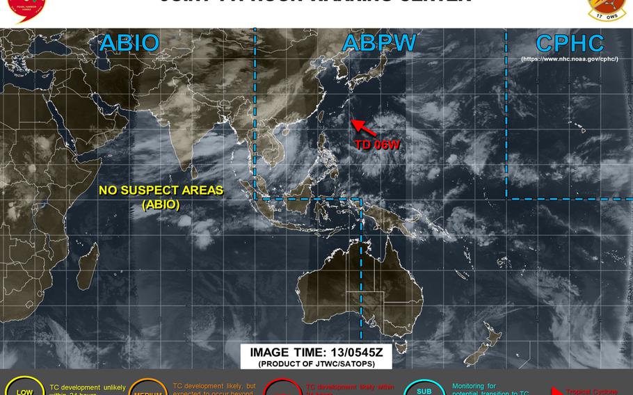
Final warning has been issued on Tropical Depression 06W, forecast to dissipate south of Okinawa late Thursday. (Joint Typhoon Warning Center)
12:45 p.m. Thursday, Aug. 13, Japan time: Final warning has been issued on Tropical Depression 06W by Joint Typhoon Warning Center. At 9 a.m., 06W was 269 miles east-southeast of Kadena Air Base, Okinawa, and had weakened into what JTWC termed a "remnant wave," with little convection and no circulation center, 18-mph sustained winds and 29-mph gusts. JTWC depicts 06W as rapidly decaying and forecasts it to dissipate sometime Thursday evening, about 165 miles south of Okinawa. GFS and CMC forecast ensembles show what's left of 06W continuing west toward China.Kadena's weather forecast calls for winds increasing Thursday afternoon, easterly at 20-mph sustained with gusts up to 32 mph overnight Thursday into Friday morning, with scattered light to moderate rainshowers. Unless it regenerates, this should be Storm Tracker's final report on 06W.11:30 p.m. Wednesday, Aug. 12, Japan time: Only change to the last update is, Tropical Depression 06W's forecast track has edged further south, closest point of approach now 121 miles south of Kadena Air Base, Okinawa, at 1 a.m. Friday. All wind parameters remain the same, 29-mph sustained winds and 40-mph gusts at center. U.S. bases on Okinawa remain in seasonal Tropical Cyclone Condition of Readiness 4.6 p.m. Wednesday, Aug. 12, Japan time: Tropical Depression 06W is holding steady at 29-mph sustained winds and 40-mph gusts and is forecast to maintain that intensity, passing 94 miles south of Kadena Air Base, Okinawa, at about midnight Thursday. At 3 p.m. Wednesday, 06W was 472 miles east of Kadena, tracking west-southwest at 13 mph. Joint Typhoon Warning Center forecasts 06W to curve west-northwest after passing Kadena. JTWC also reports potential for the system to dissipate in the next couple to three days, and a spread of between 58 and 127 miles among model solutions between 1 1/2 to 2 days out. Next update about midnight. U.S. bases on Okinawa remain in seasonal Tropical Cyclone Condition of Readiness 4.1 p.m. Wednesday, Aug. 12, Japan time: To use a baseball analogy ... like the underdog team facing two outs, nobody on and down by 10 runs in the bottom of the ninth, Tropical Depression 06W simply refuses to go away. At 9 a.m., 06W was 544 miles east of Kadena Air Base, Okinawa, had curved slightly west-southwest at 12 mph and holding steady at 29-mph sustained winds and 40-mph gusts at center. Joint Typhoon Warning Center forecasts 06W to hold at that intensity, keep moving west-southwest for the next 1 1/2 days, passing 93 miles south of Kadena at 1 a.m. Friday, then move west-northwest, just north of Miyako and Ishigaki islands to Okinawa's southwest. U.S. bases on Okinawa remain in seasonal Tropical Cyclone Condition of Readiness 4. Kadena's weather forecast calls for winds to pick up Thursday, northeasterly shifting easterly at 18 mph with gusts as high as 32, with showers and possible thunderstorms into Friday. JTWC projects some spread among model solutions. Both the GFS and CMC forecast ensembles' best tracks generally agree with the JTWC forecast track and depict 06W headed toward eastern China. In sum, credit 06W for persistence. Interesting, this pesky one. Bears some watching. Not expecting a typhoon by any means at this point, but some gusty, rainy weather approaching.Midnight Tuesday, Aug. 11, Japan/Korea time: Again not much change to Tropical Depression 06W in the last six hours, other than a slight adjustment to its forecast closest point of approach to Okinawa. It remains a weak system and is forecast to stay that way. At 9 p.m., 06W was 722 miles east of Kadena Air Base, moving almost due west at 11 mph, holding steady at 29-mph sustained winds and 40-mph gusts at center. U.S. bases on Okinawa remain in seasonal Tropical Cyclone Condition of Readiness 4. If it remains on its present track, Joint Typhoon Warning Center forecasts it to keep moving generally west, passing 80 miles south of Kadena at mid-afternoon Friday with 23-mph sustained winds and 35-mph gusts at center. A bit of postscript to Tropical Storm Jangmi, which passed over the southeast corner of the Korean Peninsula at midafternoon Monday. Though no significant damage was reported, Jangmi was another gusty, rainy episode in what could become the longest monsoon season on record in South Korea. Monsoon season began June 24, according to Korea Meteorological Agency via multiple media reports. And it has kept going, with rain forecast to continue perhaps through Friday, which would make the monsoon season a record 52 days and surpass the 49 set in 2013. Multiple media reported more than 9,000 homes and 14,000 total facilities have been damaged by rain and resulting flooding, with more than 7,000 people displaced.
The Han River which bisects metropolitan Seoul, the Korean capital, overflowed its banks earlier this month thanks to monsoon rains and Tropical Cyclone Hagupit. Highways and roads near the Han were closed and the Jamsu Bridge, or the lower portion of the Banpo Grand Bridge, one of the main arteries across the Han, was flooded except for the little hump, visible just above the water. "Longest monsoon season I've ever seen, for sure," said Charles Woodruff, 66, a retired Army first sergeant who for decades was the librarian at the former Seoul American High School. He splits time between Seoul and his upstate New York residence.6 p.m. Tuesday, Aug. 11, Japan time: Little change to Tropical Depression 06W in the last six hours. At 3 p.m., it was 783 miles east of Kadena Air Base, Okinawa, moving west at 11 mph with 29-mph sustained winds and 40-mph gusts at center. If it remains on its present course, Joint Typhoon Warning Center projects 06W to retain its current intensity, curve slightly west-southwest and pass 74 miles south of Kadena at mid-afternoon Friday, with 23-mph sustained winds and 35-mph gusts at center.JTWC reports 06W's environment is marginal, with some potential for it to dissipate before it reaches Okinawa's neighborhood, along with a spread among model solutions of 58 to 81 miles.Noon Tuesday, Aug. 11, Japan time: With Jangmi long gone, now attention turns to that tropical depression, still well to Okinawa's east; and Mekkhala, which reached Category 1-equivalent typhoon strength as it rammed ashore over southeastern China Tuesday morning.06W weakened to a tropical depression overnight Monday. At 9 a.m., it was 125 miles north of Iwo Jima and 840 miles east of Kadena Air Base, Okinawa, moving west at 14 mph and had weakened to 29-mph sustained winds and 40-mph gusts. Joint Typhoon Warning Center forecasts 06W to keep moving generally west and hold steady at those wind values for the next three days before weakening further, 23-mph sustained winds and 35-mph gusts at mid-morning Friday. If it remains on its present heading, 06W is forecast to dissipate just as it passes 44 miles south of Kadena at about 9 a.m. Saturday. JTWC reports a spread of about 115 miles three days out and 173 miles four days out. U.S. bases on Okinawa remain in seasonal Tropical Cyclone Condition of Readiness 4.Kadena's long-range weather forecast currently indicates clouds and some middling gusts Friday into Saturday. Japanese weather forecast calls for sunny skies both Friday and Saturday. If 06W's forecast track holds, and especially if it somehow intensifies, expect both to change as the week wears on. As for Mekkhala, it intensified into a Category 1-equivalent typhoon and came ashore at about 8 a.m. east China time southeastsern China's Fujian province. In its final warning on the system issued at noon, JTWC forecasts Mekkhala to steadily weaken due to frictional effects as it moves over China's rugged terrain, then dissipate early Thursday northwest of Shanghai.5:45 p.m. Monday, Aug. 10, Japan/Korea time: Tropical Storm Jangmi has weakened slightly, with closest point of approach to Naval Base Chinhae having come and gone. It's forecast by Joint Typhoon Warning Center to move northeast through the Sea of Japan toward the north tip of Hokkaido in northern Japan by Tuesday evening. At 3 p.m., Jangmi was 56 miles south of Chinhae, moving north-northeast at 26 mph packing 40-mph sustained winds and 52-mph gusts at storm's center. Chinhae has reverted to seasonal Tropical Cyclone Condition of Readiness 4 as of 6 p.m., though heavy rain is still expected through Monday evening, Chinhae said in a message to Stripes. If Jangmi remains on its present heading, it's forecast by JTWC to pick up speed but retain its current strength as it passes Hokkaido early evening Tuesday. Regarding the other two tropical cyclones in the region: -- Tropical Storm 07W (Mekkhala): It has acquired a name, which means angel of thunder in Thai. At 3 p.m., Mekkhala was 382 miles south-southwest of Taipei and 723 miles southwest of Kadena Air Base, Okinawa, moving north at 12 mph packing 40-mph sustained winds and 52-mph gusts. JTWC forecasts Mekkhala to peak at 52-mph sustained and 63-mph gusts before making landfall at mid-afternoon Tuesday over southeastern China. -- Tropical Storm 06W: At 3 p.m., it was 267 miles east-southeast of Iwo Jima and 1,090 miles east of Kadena, moving west at 11 mph and had weakened slightly to 40-mph sustained winds and 52-mph gusts. JTWC forecasts 06W to weaken gradually and dissipate about 290 miles east of Kadena at mid-afternoon Thursday. Next update at mid-morning Tuesday.5 p.m. Monday, Aug. 10, Japan time: With closest point of approach by Tropical Storm Jangmi now come and gone, Fleet Activities Sasebo has directed Tropical Cyclone Condition of Readiness All Clear for Sasebo Naval Base and its satellite properties.11:15 a.m. Monday, Aug. 10, Japan/Korea time: Tropical Storm Jangmi has put the pedal to the metal, accelerating quickly toward the southeast corner of Korea with passage forecast for around 4 p.m. Monday, according to the Joint Typhoon Warning Center. Meanwhile, 07W well to Okinawa's southwest has been upgraded to a tropical storm by JTWC, while 06W to Okinawa's east has weakened slightly. At 9 a.m., Jangmi was 132 miles west-southwest of Sasebo Naval Base, Japan, moving rapidly north-northeast at 35 mph and holding steady at 46-mph sustained winds and 58-mph gusts. JTWC projects Jangmi to maintain that intensity, but move in and out of the area in short order after passing 79 miles northwest of Sasebo, 36 miles southeast of Naval Base Chinhae and 54 miles southeast of Daegu between noon and 4 p.m. And all the rain associated with it, further dampening the Peninsula. Chinhae and Daegu-Area IV remain in Tropical Cyclone Condition of Readiness 3, while Sasebo remains in TCCOR Storm Watch until 2 p.m. Tuesday. From there, Jangmi is forecast to push quickly through the Sea of Japan, transitioning to an extra-tropical low as it crosses Hokkaido in northern Japan late Tuesday into Wednesday. As for the other two tropical storms out there: -- Tropical Storm 06W: Was 1,150 miles east of Kadena Air Base, Okinawa, at 9 a.m. Monday, tracking almost due west at 7 mph and had weakened slightly to 46-mph sustained winds and 58-mph gusts at center. If it remains on course, JTWC forecasts it to keep diminishing and finally dissipating at mid-morning Friday, still 334 miles east of Kadena. -- Tropical Storm 07W: This was upgraded at mid-morning by JTWC and was 765 miles southwest of Kadena at 9 a.m. and had slightly strengthened to 40-mph sustained winds and 52-mph gusts at center. If it keeps moving as forecast, JTWC projects it to keep moving north and make landfall about noon Tuesday and decay as it moves over southeastern China. 07W lies within the Philippines' Area of Responsibility and Tropical Cyclone Wind Signal 1 has been raised for portions of Western Luzon by the national weather authority PAGASA.8:45 a.m. Monday, Aug. 10, Japan/Korea time: With Tropical Storm Jangmi moving north away from the island, U.S. bases on Okinawa have reverted to seasonal Tropical Condition of Readiness 4, according to Kadena Air Base's 18th Wing Weather Flight. At 3 a.m., Jangmi was 215 miles north-northwest of Kadena, moving almost due north at 21 mph and had strengthened to 46-mph sustained winds and 58-mph gusts at storm's center.Kadena's weather forecast calls for continued gusty, rainy conditions, with winds southeasterly as high as 40 mph sustained and 46-mph gusts through the morning, diminishing as day wears on, with a chance of on-and-off showers and thunderstorms. Joint Typhoon Warning Center forecasts Jangmi to keep homing in on the southeastern corner of Korea, making landfall just past mid-afternoon at the same intensity, with more rain in store for an already saturated peninsula. If it remains on its present heading, Jangmi is forecast to pass over or near Naval Base Chinhae, Kimhae Airport, Pohang and Busan and 28 miles southeast of Daegu between 5 and 7 p.m. It's also due to pass 97 miles northwest of Sasebo Naval Base in southwestern Japan just past noon. Chinhae and Daegu-Area IV remain in TCCOR 3 while Sasebo continues in TCCOR Storm Watch. Sasebo's weather forecast calls for winds peaking between 35 and 40 mph sustained with 52-mph gusts at mid-day Monday, with various watches and warnings in effect. And we still have two other tropical cyclones populating the northwest Pacific: -- Tropical Storm 06W: At 3 a.m., it was 1,185 miles east of Kadena, moving west at 5 mph and had strengthened to 52-mph sustained winds and 63-mph gusts. JTWC projects 06W to keep tracking west, gradually weakening and dissipating early Friday morning, still about 360 miles east of Kadena. -- Tropical Depression 07W: At 3 a.m., it was 305 miles north-northwest of Metro Manila, moving north at 15 mph with 35-mph sustained winds and 46-mph gusts at center. It's forecast to pass just west of Taiwan and plow into southeastern China at mid-morning Tuesday, then dying out over land.11:15 p.m. Sunday, Aug. 9, Japan/Korea time: Not just one, not two, but three tropical cyclones now populate the northwest Pacific. For the moment, Tropical Storm Jangmi is the closest and the most imminent threat of the three to U.S. bases in the region, forecast to clip the southeast corner of Korea late Monday afternoon. Meanwhile, new Tropical Storm 06W is well east of Okinawa and headed west, while Tropical Depression 07W is just west of Luzon in the northern Philippines, heading north toward China. Joint Typhoon Warning Center forecasts Jangmi to pass near or over Busan, Kimhae Airport and Naval Base Chinhae and 34 miles southeast of Daegu between 4 and 5 p.m. Monday, and 103 miles northwest of Sasebo Naval Base in northern Japan at noon. Chinhae and Daegu-Area IV remained Tropical Cyclone Condition of Readiness 3 as of late Sunday, while Sasebo and U.S. bases on Okinawa remain in TCCOR Storm Watch. At 9 p.m., Jangmi was 110 miles northwest of Kadena Air Base, moving briskly north at 25 mph, packing 40-mph sustained winds and 52-mph gusts. It's forecast to peak at 46-mph sustained and 58-mph gusts as it approaches southeast Korea. Now, for the other two cyclones which spawned Sunday evening: -- Tropical Storm 06W at 9 p.m. was 403 miles east of Iwo Jima and 1,228 miles east of Kadena, moving west at 8 mph packing 40-mph sustained winds and 52-mph gusts at center. JTWC projects 06W to weaken into a tropical depression, possibly dissipating by Wednesday, still well east of Okinawa. -- Tropical Depression 07W at 9 p.m. was 903 miles southwest of Kadena and 235 miles northwest of Metro Manila, moving almost due north at 12 mph, with 29-mph sustained winds and 40-mph gusts at center. JTWC forecasts 07W to track north and make landfall at mid-afternoon Tuesday over southeastern China. They're new cyclones, so much can change. Next update at mid-morning Monday.7 p.m. Sunday, Aug. 9, Japan/Korea time: Here is the latest wind-forecast timeline for Okinawa from Tropical Storm Jangmi, courtesy of Kadena Air Base's 18th Wing Weather Flight. U.S. bases on Okinawa remain in Tropical Cyclone Condition of Readiness Storm Watch: -- Peak winds of 40-mph sustained, 46-mph gusts for Kadena, 52-mph gusts elsewhere: Already occurring from 6 p.m., and forecast to continue the rest of the evening. -- Winds subsiding below 40-mph sustained: 1 a.m. Monday. Between 3 to 5 inches of rain associated with Jangmi remain in the forecast, continuing into Tuesday, the weather flight reports.6 p.m. Sunday, Aug. 9, Japan/Korea time: Boy, tropical traffic has picked up in the last few hours. In addition to Jangmi being upgraded to a tropical storm, the Joint Typhoon Warning Center has issued tropical cyclone formation alerts on two new disturbances, 95W and 96W Invest. At 3 p.m., 95W was 196 miles west-northwest of Metro Manila, tracking north at 6 mph, while 96W was 927 miles north of Guam and 1,266 miles east of Kadena Air Base, Okinawa, crawling west at 5 mph. For now, model track guidance and GFS and CMC forecast ensembles show 95W tracking just west of Luzon in the northern Philippines, over or near Taiwan and skimming the east coast of China into the Yellow Sea (West Sea) near the Korean Peninsula. Much land interaction. Much different for 96W, which is well out at sea. Model track guidance and GFS and CMC ensembles depict a generally westward track, with not much development in the short term. That could change. It's fairly far north. But much remains to be seen. As for Jangmi, it was 120 miles southwest of Kadena at 3 p.m., tracking north at a brisk 26 mph and had strengthened to 40-mph sustained winds and 52-mph gusts at storm's center. U.S. bases remain in Tropical Cyclone Condition of Readiness Storm Watch. If Jangmi continues on its present course, JTWC forecasts it to pass 87 miles west of Kadena at 6 p.m. From there, JTWC projects Jangmi to peak at 46-mph sustained winds and 58-mph gusts early Monday morning and maintaining that intensity as it reaches the southeastern coast of the Korean Peninsula at mid-afternoon Monday. Jangmi is forecast to move quickly over or near Naval Base Chinhae, Kimhae Airport and Busan, 30 miles southeast of Daegu and 104 miles northwest of Sasebo Naval Base in southwestern Japan between noon and 5 p.m. Monday before moving into the Sea of Japan (East Sea). Chinhae and Daegu-Area IV remain in TCCOR 3, while Sasebo remains in TCCOR Storm Watch.Sasebo's weather forecast still calls for winds to peak at 40-mph sustained and 52-mph gusts at noon Monday. 1 p.m., Sunday, Aug. 9, Japan/Korea time: Korea has already seen its share of rain, but the already saturated peninsula is forecast to get even more with the forecast approach of Tropical Depression Jangmi. Joint Typhoon Warning Center forecasts Jangmi to make landfall early Monday afternoon over the southeast corner of Korea. It's projected to make almost direct passes over Naval Base Chinhae and Kimhae Airport, moving just northwest of Pusan and 25 miles southeast of Daegu at about 2 p.m. Monday. Chinhae and Area IV remain in Tropical Cyclone Condition of Readiness 3.At least 30 have died and 12 are missing due to rains which have already flooded portions of Korea, including the capital city of Seoul. More can yet be expected along the south coast as Jangmi approaches. In southwestern Japan, Sasebo Naval Base has set TCCOR Storm Watch, in effect until 2 p.m. Tuesday, according to Sasebo's official weather forecast. Jangmi is forecast to pass 107 miles northwest of the base at about noon Monday. Sasebo's forecast calls for peak winds at about noon Monday, southerly between 35 and 40 mph sustained and 52-mph gusts. As for Okinawa, U.S. bases there remain in TCCOR Storm Watch as well, with the worst forecast to come Sunday afternoon and evening as Jangmi passes to Okinawa's west. At noon, Jangmi was about 250 miles south-southwest of Kadena Air Base, moving due north at a brisk 21 mph, packing 35-mph sustained winds and 46-mph gusts at center. If Jangmi keeps on its present heading, JTWC forecasts it to pass 90 miles west of Kadena at 6 p.m. Here is the latest wind-forecast timeline from Kadena's 18th Wing Weather Flight: -- Onset of 40-mph sustained winds: 4 p.m. Sunday. -- Peak winds of 40-mph sustained and 46-mph gusts for Kadena, 52-mph gusts elsewhere: 6 p.m. Sunday. -- Winds diminishing below 40-mph sustained: 1 a.m. Monday. The weather flight forecasts between 3 to 5 inches of rain associated with Jangmi.Noon Sunday, Aug. 9, Japan/Korea time: Naval Base Chinhae and Daegu-Area IV have set Tropical Cyclone Condition of Readiness 3 at 6 a.m. Sunday. Destructive winds of 58 mph or greater are possible within 48 hours.7 a.m. Sunday, Aug. 9, Japan time: Okinawa can expect gusts up to 52 mph as Tropical Depression 05W remains forecast to pass west of the island late Sunday afternoon, according to the Joint Typhoon Warning Center and Kadena Air Base's 18th Wing Weather Flight. At 3 a.m., 05W was 373 miles south-southwest of Kadena, moving rapidly north at 21 mph and had strengthened slightly to 35-mph sustained winds and 46-mph gusts at storm's center. If 05W remains on its current course, JTWC forecasts it to pass 84 miles west of Kadena at 5 p.m. Sunday, packing 40-mph sustained winds and 52-mph gusts at center. Here is the latest wind-forecast timeline for Okinawa, courtesy of 18th Wing Weather Flight. U.S. bases on Okinawa remain in Tropical Cyclone Condition of Readiness Storm Watch: -- Onset of 40-mph sustained winds: Noon Sunday. -- Peak 40-mph sustained winds and 46-mph gusts for Kadena, 52-mph gusts elsewhere on island: 5 p.m. Sunday. -- Winds subsiding below 40-mph sustained: 1 a.m. Monday. Plenty of rain associated with 05W as well; the weather flight forecasts between 3 to 5 inches of rainfall. As for locales north, 05W is forecast to peak at 46-mph sustained winds and 58-mph gusts, maintaining that strength as it curves north and crosses the southeastern corner of the Korean Peninsula Monday afternoon. JTWC projects 05W to pass over or close to Naval Base Chinhae and Kimhae Airport and pass 22 miles northwest of Busan at about 4 p.m. Monday. It's forecast to pass 105 miles northwest of Sasebo Naval Base in southwestern Japan at about mid-day Monday. Note that while JTWC still carries 05W as a tropical depression, Japan Meterological Agency has upgraded it to a tropical storm named Jangmi, which is Korean for rose.Midnight Saturday, Aug. 8, Japan time: Latest update on Tropical Depression 05W shows the forecast track having edged a tad closer to Okinawa. But it's still forecast by Joint Typhoon Warning Center to pass about 95 miles west of Kadena Air Base at around 7 p.m. Sunday as a tropical storm, 52-mph sustained winds and 63-mph gusts at storm's center. At 9 p.m., 05W was 491 miles south-southwest of Kadena and 482 miles northeast of Metro Manila, moving almost due north at 14 mph and had strengthened slightly, to 29-mph sustained winds and 40-mph gusts. U.S. bases on Okinawa remain in Tropical Cyclone Condition of Readiness Storm Watch. The news gets a bit better for locales north, as JTWC now forecasts 05W to peak at 52-mph sustained and 63-mph gusts as it passes Kadena, and split the difference between bases on Korea's southeast coast and Kyushu in southwestern Japan as it passes Monday. If 05W remains on its present heading, it's now forecast to pass 81 miles northwest of Sasebo Naval Base at 4 p.m. Monday and 25 miles southeast of Busan, 46 miles southeast of Naval Base Chinhae and 37 miles southeast of Kimhae Airport two hours later. Still very early in the life of a young storm. Much can change regarding forecast track and intensity. Updated wind forecast timeline when available. If 05W becomes a named storm, it would be called Jangmi, a Korean word for rose.7:15 p.m. Saturday, Aug. 8, Japan time: Here is the initial wind-forecast timeline for U.S. bases on Okinawa from Tropical Depression 05W, courtesy of Kadena Air Base's 18th Wing Weather Flight: -- Onset of 40-mph sustained winds: 10 a.m. Sunday. -- Peak 40-mph sustained winds, 46-mph gusts for Kadena; 46-mph sustained, 52-mph gusts elsewhere on island: 5 p.m. Sunday. -- Winds subsiding below 40-mph sustained: 1 a.m. Monday. Kadena Weather Flight forecasts between 2 to 4 inches of rain associated with 05W. U.S. bases on Okinawa remain in Tropical Cyclone Condition of Readiness Storm Watch.6:30 p.m. Saturday, Aug. 8, Japan time: Say hello to the fifth numbered tropical cyclone of the northwest Pacific's season.Tropical Depression 05W has spawned 434 miles northeast of Metro Manila and 495 miles south-southwest of Kadena Air Base, Okinawa, moving almost due north at 9 mph. Joint Typhoon Warning Center forecasts 05W to keep moving north, gradually intensifying, packing 35-mph sustained winds and 46-mph gusts as it passes 125 miles west of Kadena at about 5 p.m. Sunday.Kadena's weather forecast remains the same from Saturday morning, with winds peaking southeasterly at 34-mph sustained Sunday afternoon and evening. Kadena does appear to be within JTWC's forecast 34-knot (39-mph) wind bands as it makes its projected pass. U.S. bases on Okinawa remain in Tropical Cyclone Condition of Readiness Storm Watch. Whether that gets upgraded or not depends on whether 05W veers further east off its forecast track and intensifies more than projected. JTWC at the moment does not forecast 05W to become a typhoon, peaking at 58-mph sustained winds as it curves northeast toward the southern edges of the Korean peninsula, which has seen enough rain lately. It's projected to make a near-direct hit on Kimhae International Airport and passing 18 miles south of Naval Base Chinhae and 12 south of Busan at about 5 p.m. Monday. 05W is forecast to pass 110 miles northwest of Sasebo Naval Base in southwestern Japan about three hours earlier. As for 95W Invest, initial model-track guidance and the GFS and CMC forecast ensembles depict it skimming the west coast of Luzon in the northern Philippines, passing over Taiwan and skirting the east coast of China. Much interaction with land, which could hinder development. Next update at about midnight Saturday, or sooner, depending on developments. Get your safe on, Okinawa!3:30 p.m. Saturday, Aug. 8, Japan time: While U.S. bases on Okinawa keep a watchful eye on 94W Invest, a second tropical disturbance has surfaced about 200 miles west of Manila, 95W Invest. Joint Typhoon Warning Center has labeled 95W a "low" area for development in the next 24 hours, adding it's forecast to track north and intensify. For now, U.S. bases on Olinawa remain in Tropical Cyclone Condition of Readiness Storm Watch.8 a.m. Saturday, Aug. 8, Japan time: U.S. bases on Okinawa have entered Tropical Cyclone Condition of Readiness Storm Watch due to developing disturbance 94W Invest.6:30 a.m. Saturday, Aug. 8, Japan time: A tropical cyclone formation alert has been issued on disturbance 94W Invest by the Joint Typhoon Warning Center. U.S. bases on Okinawa remain in seasonal Tropical Cyclone Condition of Readiness 4 for the moment. Though destructive winds are not forecast at this time, the island can still expect rainy, blustery conditions as the coming week unfolds.Kadena Air Base's weather forecast calls for an 80-percent chance of rainshowers and thunderstorms Sunday evening into Monday. Expect winds to pick up Saturday afternoon, peaking Sunday evening, southeasterly to southerly at 34-mph sustained with gusts between 53 and 65 mph, then Monday morning 31-mph sustained with gusts between 45 and 65 mph, diminishing from there.Model track guidance and the GFS and CMC forecast ensembles depict movement north, splitting the difference between Okinawa and Ishigaki Islands. Next update at mid-day Saturday.9:30 p.m. Friday, Aug. 7, Japan time: Very quickly, 94W Invest has been upgraded to a "medium" area for development into a tropical cyclone in the next 24 hours by Joint Typhoon Warning Center. U.S. bases on Okinawa remain in seasonal Tropical Cyclone Condition of Readiness 4. Whether that's upgraded or not depends on how strong 94W becomes and how close it might come to Okinawa. No way to say one way or the other at this point.Model track guidance and the GFS and CMC forecast ensembles depict a close pass to the island two days out or thereabouts, and be out of the area in short order. But it has yet to develop into a tropical cyclone of any description. It's a wait-and-see game for now.3 p.m. Friday, Aug. 7, Japan time: 94W Invest has been designated a "low" area for development into a tropical cyclone in the next 24 hours, according to the Joint Typhoon Warning Center. JTWC projects 94W to track north and develop and intensify in the next 24 to 36 hours, pretty much mirroring model track guidance and the GFS forecast ensemble. Next update about midnight Friday.1 p.m. Friday, Aug. 7, Japan time: Still too soon to say if 94W Invest might spin up into a tropical cyclone of some description. What Okinawa can expect on Sunday, however, is heavy rain and gusty winds, stretching into the new week, according to Kadena Air Base's and local Japanese weather forecasts. At noon Friday, 94W was lurking about 790 miles south-southwest of Kadena, according to the Joint Typhoon Warning Center. U.S. bases on Okinawa remain in seasonal Tropical Cyclone Condition of Readiness 4 at the moment.Model track guidance and the GFS forecast ensemble still depict 94W moving north, just to Okinawa's west, about 2 1/2 days out as a tropical storm, then tracking north toward the Korean peninsula, which could be affected three or four days out. How strong 94W might become, and how close it might pass to Okinawa, remains to be seen. And Korea has had plenty of rain in recent days; might more be in the offing? Kadena's Shogun Weather forecast calls for winds and rain to pick up as the weekend unfolds, with a 50-percent chance of rain, showers and thunderstorms Saturday evening, increasing to 80 percent Sunday Winds are forecast to peak Sunday, southeasterly at 29-mph sustained with gusts up to 56 mph Sunday afternoon and evening into Monday. Not typhoon strength, but still significant. Enough that we might consider moving smaller loose objects indoors, perhaps break down the trampoline and keep it inside until the gustiness subsides. Storm Tracker is eyeing this one. Next update early Friday evening.10 p.m. Thursday, Aug. 6, Japan time: A disturbance labeled 94W Invest is lurking just east of Visayas in central Philippines, which could affect Okinawa in the next few days.
Model track guidance and the GFS forecast ensemble indicate it could pass just west of Okinawa, though how strong at this point is hard to say.
U.S. bases for the moment remain in seasonal Tropical Cyclone Condition of Readiness 4. Storm Tracker is keeping an eye on this one. Next update at mid-day Friday.
