()
4:30 p.m. Wednesday, Aug. 23, Hong Kong time: The first Signal 10 typhoon to hit Hong Kong in five years shut down schools and financial markets, injured at least 34 and canceled more than 450 flights serving Hong Kong International Airport, Reuters reported Wednesday. At 2 p.m., Typhoon Hato was 83 miles west of Hong Kong, burrowing inland west-northwest at 18 mph, still packing 98-mph sustained winds and 121-mph gusts at center as it roared ashore Wednesday afternoon. Southeast Gale/Storm Warning Signal 8 remained in effect late Wednesday afternoon for Hong Kong; that’s expected to be scaled back as evening comes and Hato moves further inland. This is the last report on Typhoon Hato.
10 a.m. Wednesday, Aug. 23, Hong Kong time: This is only the second time since the year 2000 that the maximum Hurricane Signal 10 has been raised by the Hong Kong Observatory. And judging by Typhoon Hato’s intensity, such a signal is very much merited.
According to the Joint Typhoon Warning Center, Hato has peaked as a Category 2-equivalent typhoon, packing 104-mph sustained winds and 127-mph gusts, the strongest typhoon the city has seen in a long time.
Conditions are expected to remain the same throughout the day as Hato makes its way inland. From 9 a.m., sustained winds of 80 mph with gusts up to 104 were recorded at Waglan Island, the Hong Kong Observatory reported.
9:30 a.m. Wednesday, Aug. 23, Hong Kong time: Typhoon Hato continues to intensity and its forecast track keeps edging closer to Hong Kong. The Hong Kong Observatory raised at 9:10 a.m. the maximum storm warning Signal 10 for Hong Kong.
8:30 a.m. Wednesday, Aug. 23, Hong Kong time: With Typhoon Hato approaching Category 2-equivalent strength, Increased Gale/Storm Warning Signal 9 has been raised at 8:10 a.m. by the Hong Kong Observatory.
5:20 a.m. Wednesday, Aug. 23, Hong Kong time: No. 8 Northeast Gale/Storm Signal was raised for Hong Kong at 5:20 a.m. by the Hong Kong Observatory.
4:40 a.m. Wednesday, Aug. 23, Hong Kong time: It should be a rainy, gusty Wednesday as Typhoon Hato continues edging closer to Hong Kong.
Strong Wind Signal No. 3 remains in force; if it remains on its present course, expect Signal 8 to be raised at any moment as Hato makes its closest point of approach late Wednesday morning and makes its way inland over southeastern China.
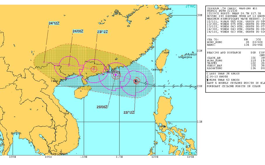
At 2 a.m., Hato was 147 miles southeast of Hong Kong, rumbling west-northwest at 14 mph, packing 75-mph sustained winds and 92-mph gusts at center. JTWC projects Hato to peak at 81-mph sustained winds and 98-mph gusts as it makes landfall at mid-day Wednesday. Closest point of approach to Hong Kong is 35 miles south-southwest at 10 a.m.
10:10 p.m. Tuesday, Aug. 22, Hong Kong time: Hato has been upgraded to a Category 1-equivalent typhoon, the fourth typhoon of the northwest Pacific tropical cyclone season, and continues to bear down on Hong Kong, according to the Joint Typhoon Warning Center.
At 8 p.m., Hato was 228 miles east-southeast of Hong Kong, headed west-northwest at 15 mph, packing 75-mph sustained winds and 92-mph gusts at center. Hato is forecast to peak at 86-mph sustained winds and 104-mph gusts as it approaches southeastern China, making landfall at about 8 a.m. Wednesday and passing 40 miles south-southwest of Hong Kong two hours later.
Hato is expected to maintain that intensity as it makes its way on shore. Strong Wind Signal 3 remains in force, according to the Hong Kong Observatory http://www.hko.gov.hk/wxinfo/currwx/tc2.htm; Signal 8 is expected to be raised during the wee hours on Wednesday, the observatory said. Heavy rain is also forecast; the observatory has warned of flash flooding in low-lying areas.
———
6:30 p.m. Tuesday, Aug. 22, Hong Kong time: Strong Wind Signal 3 was issued by the Hong Kong Observatory at 6:20 p.m. local time. Winds between 25 and 38 mph, perhaps greater, are expected. Unless Hato weakens or the track changes, No. 8 Gale or Storm Signal may be raised at around midnight.
6:15 p.m. Tuesday, Aug. 22, Hong Kong time: All tropical cyclone warning signals have been dropped for the Philippines as Tropical Storm Hato moves out of that country’s area of responsibility and continues on a west-northwest course toward Hong Kong. Meanwhile, a typhoon warning has been issued for Taiwan by the country’s Central Weather Bureau.
At 2 p.m., Hato was 317 miles east-southeast of Hong Kong, moving west-northwest at 14 mph at just-below typhoon strength, 69-mph sustained winds and 86-mph gusts at center. Joint Typhoon Warning Center projects Hato to intensify to a peak of 86-mph sustained winds and 104-mph gusts as it approaches Hong Kong, and maintaining that intensity as Hato roars ashore at mid-morning Wednesday.
Hato is due to pass 34 miles south-southwest of Hong Kong at 10 a.m. Wednesday. Wind Warning Standby Signal 1 is still in force for Hong Kong, according to the Hong Kong Observatory, which states that Strong Wind Signal 3 could be raised at any time, with Signal 8 expected to be raised about midnight
Noon Tuesday, Aug. 21, Hong Kong time: Tropical Storm Warning Signal 2 has been lowered for Batanes island group in the northern Philippines, according to the country’s weather authority PAGASA. Signal 1 remains raised for Batanes and Babuyan island groups, Cagayan, Apayao and Ilocos Norte in Luzon.
At 8 a.m., Tropical Storm Hato was 338 miles south-southwest of Taipei, Taiwan’s capital, moving west-northwest at 16 mph, its intensity increasing to 52-mph sustained winds and 63-mph gusts at center.
If Hato remains on its present track, it’s due to peak at 69-mph sustained winds and 86-mph gusts before ramming ashore at mid-morning Wednesday. Hato is forecast to pass 35 miles south-southwest of Hong Kong at 10 a.m. Standby Signal 1 is in force for Hong Kong. A tropical storm warning remains in effect for Taiwan.
5:30 a.m. Tuesday, Aug. 22, Hong Kong time: Looks more and more like Tropical Storm Hato might make a direct hit Wednesday on Hong Kong as a severe tropical storm with winds gusting up to 81 mph as it makes landfall, according to the Joint Typhoon Warning Center.
At 2 a.m., Hato was 331 miles south of Taipei, Taiwan’s capital, rumbling due west at 13 mph, packing 52-mph sustained winds and 63-mph gusts at center. If it remains on its present path, Hato is forecast to peak at 69-mph sustained winds and 86-mph gusts early Wednesday morning as it approaches Hong Kong.
Landfall over southeastern China is due at about 8 a.m. Wednesday, with Hato forecast to pass 23 miles south of Hong Kong a couple of hours later, still packing 63-mph sustained winds and 81-mph gusts as it rages over the city.
A tropical storm warning remains in effect for Taiwan, according to the Central Weather Bureau. Expect a wind warning signal to be raised for Hong Kong at any point, with a maximum Signal 8 possible Wednesday morning. Hato has passed the Batanes island group, where Tropical Cyclone Warning Signal 2 remains in effect, while Signal 1 remains raised for Cagayan, Apayao, Ilocos Norte and the Babuyan island group, according to the Philippines weather authority PAGASA.
10 p.m. Monday, Aug. 21, Hong Kong time: The news for Hong Kong gets slightly better: Tropical Storm Hato is now forecast to peak at wind speeds slightly lower than last reported, 58-mph sustained winds and 75-mph gusts as it makes landfall Wednesday morning near Hong Kong, according to the Joint Typhoon Warning Center.
At 8 p.m., Hato was 206 miles southeast of Kaohsiung in southern Taiwan, moving west-northwest at 10 mph, holding steady at 40-mph sustained winds and 52-mph gusts at center. Hato is forecast to reach peak intensity four hours before making closest point of approach to Hong Kong, 64 miles north-northeast at noon Wednesday.
A tropical storm warning remains in effect for Taiwan, according to the Central Weather Bureau. No wind warning signal has been raised for Hong Kong yet. Tropical Cyclone Warning Signal 2 remains raised for the Batanes island group and Signal 1 has been raised for the Babuyan islands, northern Cagayan, Apayao and Ilocos Norte in the Philippines, according to the national weather authority PAGASA.
5 p.m. Monday, Aug. 21, Hong Kong time:Little change, except forecast closest point of approach by Tropical Storm Hato to Hong Kong might come a couple of hours earlier than previously reported, according to the Joint Typhoon Warning Center. https://metoc.ndbc.noaa.gov/ProductFeeds-portlet/img/jtwc/products/wp1517.gif At 2 p.m., Hato was 273 miles east-southeast of Kaohsiung in southern Taiwan, headed west-northwest at 13 mph, holding steady at 40-mph sustained winds and 52-mph gusts at center. Hato is forecast by JTWC to peak at 63-mph sustained winds and 81-mph gusts early Wednesday morning. If it remains on its present path, Hato is due to continue west-southwest, passing 84 miles south-southwest of Kaohsiung at 1 p.m. Tuesday, then 62 miles north-northeast of Hong Kong about 24 hours later. A tropical storm warning remains in effect for Taiwan, according to the Central Weather Bureau. http://www.cwb.gov.tw/V7e/prevent/warning/w40.htm? No tropical cyclone warning signal has been raised for Hong Kong yet. Tropical Cyclone Warning Signal 2 remains raised for the Batanes islands and Signal 1 for the Babuyan islands in the northern Philippines, according to national weather authority PAGASA. http://www1.pagasa.dost.gov.ph/index.php/tropical-cyclones/weather-bulletins
______________________________________________________________
11:30 p.m. Monday, Aug. 21, Hong Kong time: There remains some disparity in model guidance, but Tropical Storm Hato appears to be aiming for landfall Wednesday afternoon over southeastern China. The question being, how close to Hong Kong?
At 8 a.m., Hato was 416 miles south-southeast of Taipei, Taiwan’s capital, pressing west-northwest at 8 mph, and its intensity has slightly increased, 46-mph sustained winds and 58-mph gusts at center. Joint Typhoon Warning Center forecasts Hato to peak just below typhoon strength, 69-mph sustained winds and 86-mph gusts at 8 a.m. Wednesday, just before making landfall.
If it remains on its present course, Hato is due to pass 274 miles south-southwest of Taipei and 86 miles south-southwest of Kaohsiung between 3 and 4 p.m. Tuesday. Hato is next due to pass 62 miles north-northeast of Hong Kong at 3 p.m. Wednesday.
All this could vary, depending on Hato’s actual track. It remains a relatively young system, and the GFS ensemble depicts a track just south of Hong Kong and the CMC ensemble https://www.tropicaltidbits.com/storminfo/15W_geps_latest.png shows a track just north of the city.
A tropical storm warning remains in effect for Taiwan, according to the Central Weather Bureau. Tropical Cyclone Warning Signal 2 has been raised for the Batanes islands and Signal 1 remains raised for the Babuyan islands in the northern Philippines, according to the national weather authority PAGASA. No warning signals have been raised for Hong Kong yet.
5 a.m. Monday, Aug. 21, Hong Kong time: Hong Kong might expect a less-than-welcome visitor come Wednesday.
Hato was upgraded overnight Sunday to a tropical storm by the Joint Typhoon Warning Center and could peak as a Category 1-equivalent typhoon before making landfall over southeastern China early Wednesday.
At 2 a.m., Hato was 410 miles south-southeast of Taipei, capital city of Taiwan, heading west-northwest at 20 mph, with 40-mph sustained winds and 52-mph gusts at center.
If it remains on its current path, Hato is forecast to peak at 81-mph sustained winds and 98-mph gusts early Tuesday afternoon and pass 26 miles northeast of Hong Kong at mid-day Wednesday as a severe tropical storm.
Taiwan could be spared Hato’s worst; it’s due to pass 123 miles south-southwest of Kaohsiung and 310 miles south-southwest of Taipei between 7 and 9 a.m. Tuesday. A tropical storm warning has been issued by the Taiwan Central Weather Bureau.
And the Philippines’ northernmost islands could be in for a rainy, gusty next couple of days. Tropical Cyclone Warning Signal 1 has been issued for the Batanes and Babuyan island groups by the national weather authority PAGASA.
3:45 p.m. Sunday, Taiwan time: Tropical Depression 15W has altered course slightly, and is now on track to pass over southeastern Taiwan sometime early Tuesday evening, according to the latest from the Joint Typhoon Warning Center.
At 2 p.m., 15W was 545 miles southeast of Taipei, the island’s capital, headed northwest at 8 mph. If it remains on its present course, 15W is forecast to pass 25 miles north-northeast of Kaohsiung, in southern Taiwan, and 164 miles south-southwest of Taipei at 8 p.m. Tuesday, packing 58-mph sustained winds and 75-mph gusts at center as it crashes ashore.
The change in track means better news for Hong Kong; 15W is now due to pass 192 miles northeast at 10 p.m. Wednesday.
Noon Sunday, Aug. 20, Japan time: A new tropical depression spawned Sunday morning about 470 miles south of Okinawa and is headed toward southeastern China, according to the Joint Typhoon Warning Center.
If it remains on its initial track, as-yet-unnamed 15W is due to pass 83 miles south of Kaohsiung, Taiwan, at 6 a.m. Tuesday, then 93 miles northeast of Hong Kong at 7 a.m. Wednesday. Peak intensity is forecast to be 63-mph sustained winds and 81-mph gusts as it makes landfall early Wednesday.
11 p.m. Saturday, Aug. 19, Taiwan time: A tropical cyclone formation alert has been issued on 93W Invest, a disturbance some 390 miles southeast of Okinawa, by the Joint Typhoon Warning Center. Model guidance indicates westward movement, the GFS ensemble showing 93W to be a straight-runner between Taiwan and the northern Philippines and the CMC ensemble depicting a west-northwest run through Taiwan. No indication of a turn north toward Okinawa. PST has an eye on it.
