(Joint Typhoon Warning Center)
Midnight Saturday, July 20, Korea time: Tropical Depression Danas made its way ashore about 10 p.m. just south of Kunsan Air Base, with 29-mph sustained winds, 40-mph gusts and rain, including occasionally heavy squalls. Danas is forecast to head northeast across the Korean peninsula, exiting into the East Sea sometime Sunday afternoon. Joint Typhoon Warning Center has issued its final warning on Danas, and this is Storm Tracker's final report on Danas.6:45 p.m. Saturday, July 20, Japan/Korea time: Though Danas appears to be dying down, it's certain had its impact on southern Korea and southwestern Japan, as reported by Korea's Yonhap News Agency and the Mainichi in Japan.6 p.m. Saturday, July 20, Korea time: Danas has been downgraded to a tropical depression by the Joint Typhoon Warning Center. At 3 p.m., it was 97 miles south-southwest of Kunsan Air Base, South Korea, headed north-northeast at 6 mph with 35-mph sustained winds and 46-mph gusts. It has slowed some in its approach to Korea's west coast, and is forecast to make landfall late Saturday evening, making a near-direct hit on Kunsan and passing 23 miles southeast of Osan Air Base between 11 p.m. Saturday and 5 a.m. Sunday, weakening as it heads inland. Rain and gusty winds are forecast to continue through most of Sunday, with gradual clearing behind it and a relatively nice start to the workweek on Monday.Rain appears to be in the cards on Wednesday and Friday, but hopefully, next weekend will be nicer than this one.For now, get your safe on, Korea.Noon Saturday, July 20, Japan time: Danas is making its way quickly toward Korea's west coast and, according to the Joint Typhoon Warning Center's latest forecast track, should split the difference between Osan and Kunsan Air Bases by Saturday evening as a middling tropical storm. At 9 a.m., Danas was 130 miles south-southwest of Wolf Pack Country, rumbling north-northeast at 14 mph and had weakened to 40-mph sustained winds and 52-mph gusts. U.S. bases in southeastern Area IV are in Tropical Cyclone Condition of Readiness 1; bases in all other areas of Korea are All Clear, according to Camp Humphreys' official Facebook page. Gusty, rainy conditions have already settled into the peninsula and should continue until as late as 6 p.m. Sunday. Humphreys' Facebook page reports southern coastal areas of Korea could get 58-mph gusts while other areas might see between 35- and 46-mph winds. Forecasts call for Cheju to get between 5 to 8 inches of rain and other areas between 2 to 4. JTWC forecasts Danas to make landfall just south of Osan and Camp Humphreys by mid-evening Saturday as a tropical depression, 29-mph sustained winds and 40-mph gusts as it rams ashore. Danas is forecast to pass 6 miles southeast of Osan and Camp Humphreys and 10 miles northwest of Kunsan between 7 p.m. Saturday and 1 a.m. Sunday. Stay tuned to local weather authorities and official Facebook pages for details. Folks along the south coast and on Cheju where the winds are highest should stay indoors until the All Clear is sounded.11:30 p.m. Friday, July 19, Korea time: Prepare for a wet, windy weekend on the Korean peninsula, with Kunsan Air Base along the west coast bracing for a near-direct hit from a steadily weakening Tropical Storm Danas. At 9 p.m., Danas was 306 miles south-southwest of the home of the Wolfpack, headed north-northeast at 18 mph and holding steady at 52-mph sustained winds and 63-mph gusts. U.S. Army Garrison Humphreys and Area III in the western portion of Korea are now no longer in Tropical Cyclone Condition of Readiness 2. It had been for awhile, but destructive winds of 58 mph or greater are no longer expected to occur. Danas is forecast by the Joint Typhoon Warning Center to gradually weaken as it approaches Korea's west coast, plowing ashore along the country's rugged coastline around mid-day Saturday. It's due to pass 9 miles southeast of Kunsan, 92 miles northwest of Daegu and 26 miles southeast of Osan Air Base between 7 p.m. and midnight Saturday as a tropical depression, 35-mph sustained winds and 46-mph gusts.Model guidance is in good agreement with a spread of about 86 miles, with the GFS ensembles denoting landfall further north of Kunsan, and the CMC ensembles favoring a forecast track even further north, with landfall closer to the DMZ.3 p.m. Friday, July 19, Japan time: U.S. bases on Okinawa reverted to seasonal Tropical Cyclone Condition of Readiness 4 at 3 p.m., according to a Kadena Air Base 18th Wing Weather Flight release.
12:15 p.m. Friday, July 19, Korea time: Tropical Storm Danas continues moving north at a somewhat rapid clip and is now putting U.S. bases on the west coast of South Korea in its sights, but as a fairly weak system. Still, a wet, windy weekend may be in store for the peninsula. At 9 a.m., Danas was about 670 miles south-southwest of Osan Air Base, headed almost due north at 14 mph and holding steady at 46-mph sustained winds and 52-mph gusts. U.S. bases on Okinawa remain in Tropical Cyclone Condition of Readiness Storm Watch, though probably for not much longer. If Danas continues on its present heading, it's forecast to peak at 52-mph sustained winds and 63-mph gusts sometime Friday evening, then weaken gradually as it moves north. Danas is due to pass 12 miles northwest of Kunsan Air Base, 11 miles southeast of Osan Air Base and make an almost direct hit on Camp Humphreys between 9 p.m. Saturday and 2 a.m. Sunday as a weak tropical storm, 40-mph sustained winds and 52-mph gusts. Meanwhile, the Joint Typhoon Warning Center canceled its tropical cyclone formation alert on 91W Invest. It pushed its way over southern Taiwan, which because of its rugged interior never benefits a developing system. The tropical storm warning related to Danas has been canceled, but due to 91W Invest, a heavy rain warning remains in effect for most of the southern portion of Taiwan, according to the Central Weather Bureau. 91W is barely within the Philippines area of responsibility and has been named Goring by the national weather authority PAGASA. Tropical Cyclone Warning Signal 1 is raised for the Batanes island group, PAGASA reports. PST will keep an eye on it, and on Danas as it moves north.Midnight Thursday, July 18, Japan time: Tropical Storm Danas continues on its journey north, has passed Okinawa and left it in its rear-view mirror and appears to be keeping the southwest portion of the Korean peninsula in its sights. At 9 p.m., Danas was 230 miles west of Kadena Air Base, moving north at 12 mph, holding steady at 46-mph sustained winds and 58-mph gusts at center. U.S. bases on Okinawa remain in Tropical Cyclone Condition of Readiness Storm Watch. Kadena's 18th Wing Weather Flight Web page states that Okinawa should be getting 40-mph sustained winds and 52-mph gusts from 7 p.m. Thursday. That should keep up through at least Saturday evening, once Danas is out of the area and possibly 91W Invest following on its heels, depending on how much that consolidates and how strong a cyclone it becomes. Should Danas stay on its present heading, it's due to peak at 52-mph sustained winds and 63-mph gusts as it heads through the East China Sea, gradually weakening as it rumbles toward the Korean peninsula. Danas is forecast to make a direct hit on Kwangju Air Base, pass 39 miles southeast of Kunsan Air Base and 110 miles northwest of Pusan between 9 p.m. Saturday and 2 a.m. Sunday as a middling tropical storm. Model guidance remains in tight agreement regarding Danas and 91W as well, though the GFS ensemble continues to not show much of a best track, while the CMC ensemble's best track goes all the way through Korea into the East Sea. Looks like Korea's turn to get buffetted this weekend. Elsewhere, Taiwan remains under a tropical storm warning and some southern counties under a heavy rain advisory, according to the Central Weather Bureau; that should not keep up much longer.7 p.m. Thursday, July 18, Japan time: U.S. bases on Okinawa have entered Tropical Cyclone Condition of Readiness Storm Watch as of 7 p.m., according to a release from the Kadena Air Base 18th Wing Weather Flight. Closest point of approach by Tropical Storm Danas was forecast to be 222 miles west of Kadena at 7 p.m., with 46-mph sustained winds and 58-mph gusts. Close enough that the island can expect 35-mph sustained winds and 46-mph gusts, with rainshowers that could increase the wind speed slightly. Bottom line: Okinawa is not forecast to get destructive winds of 58 mph or greater, the release stated.6 p.m. Thursday, July 18, Japan time: Closest point of approach by Tropical Storm Danas to Kadena Air Base, Okinawa, has just about come and gone. The questions remain, how strong will Danas be as it heads toward the southern Korean coast, and will 91W Invest be right behind it? At 3 p.m., Danas had already made its closest point of approach to Taipei and was 230 miles west-southwest of Kadena, rumbling north at 21 mph and had strengthened slightly, to 46-mph sustained winds and 58-mph gusts at center. U.S. bases on Okinawa remain in Tropical Cyclone Condition of Readiness 3. If Danas stayed on its present heading, it's forecast to pass 222 miles west-northwest of Kadena by 7 p.m. Thursday. Much quicker than previously forecast. Kadena's extended forecast continues to call for peak southerly 40-mph sustained winds and 51-mph gusts Friday evening into Saturday morning, with up to a 60-percent chance of showers and thunderstorms. Danas is forecast to peak at 52-mph sustained winds and 63-mph gusts and keep moving toward the southwestern corner of the Korean peninsula. It's due to pass 10 miles southeast of Kwangju Air Base and 45 miles southeast of Kunsan Air Base between 7 and 10 p.m. Saturday, still packing 40-mph sustained winds and 52-mph gusts. Model guidance has tightened over the last day or so, with both the GFS and CMC ensembles in tight agreement with the JTWC forecast track. Elsewhere, Danas, named Falcon by the Philippines national weather authority PAGASA, has left the Philippines Area of Responsibility, with all Tropical Cyclone Warning Signals lifted. A tropical storm warning remains in effect for Taiwan along with a heavy rain advisory for southern and eastern parts of Taiwan, according to its Central Weather Bureau. And as for 91W Invest ... hmm ... Still too early to tell what it might do. Preliminary indicators are mixed, with the GFS ensemble not even offering a best track much past Taiwan, while the CMC ensemble favors a best track all the way through central Korea in three days or so. Stay tuned. More to come.12:45 p.m. Thursday, July 18, Japan time: A new disturbance, 91W Invest, has formed southwest of Tropical Storm Danas, and is forecast by the Joint Typhoon Warning Center to follow Danas northeast over the next few days. JTWC has issued a tropical cyclone formation alert on 91W. We'll see what happens. Other than that, there's little change to Danas. The latest forecast track edges Danas a bit further west of Okinawa than previously forecast. Heavy rain and gusty winds remain in the forecast. At 9 a.m., Danas was 205 miles southeast of Taipei, Taiwan's capital, and 305 miles southwest of Kadena Air Base, moving due north at 21 mph, holding steady at 40-mph sustained winds and 52-mph gusts. Danas is not forecast to intensify much more, JTWC reports, peaking at 46-mph gustained winds and 58-mph gusts Thursday evening. If Danas continues on its present course, it's forecast to pass 161 miles east of Taipei at 6 p.m. Thursday and 213 miles west-northwest of Kadena at 6 a.m. Friday. U.S. bases on Okinawa remain in Tropical Cyclone Condition of Readiness 3. Kadena's extended weather forecast continues to call for gusty conditions through Saturday, southeasterly winds up to 40 mph with 51-mph gusts and up to 80 percent chance of showers and thunderstorms. Should Danas survive that long, it should reach the southern portion of the Korean peninsula as a weak tropical depression, edging within 64 miles of Pusan and 26 miles of Daegu between 8 and 9 a.m. Sunday. Elsewhere, a tropical storm warning remains in effect along with extremely heavy rain advisories for Taiwan, according to its Central Weather Bureau. In the Philippines, Tropical Cyclone Warning Signal 1 remains raised for the Batanes island group, according to the national weather authority PAGASA. Signal 1 for the Babuyan islands has been lifted. Regarding 91W Invest, initial model guidance reads very much like that of Danas, with the GFS and CMC forecast ensembles showing a northeast track in Korea's general direction. Stay tuned.6 a.m. Thursday, July 18, Japan time: Slightly better news for Okinawa: Tropical Storm Danas' latest forecast track edges it a bit further west of Kadena Air Base than previously forecast. For the moment, U.S. bases remain in Tropical Cyclone Condition of Readiness 3. And it doesn't appear as though Danas will be quite as strong as previously forecast as it passes west of Okinawa around mid-morning Friday. Rain squalls and gusty winds are already starting to buffet Okinawa. Some of the squalls can be a bit blinding. Already, leaves, tree branches and other debris can be seen on roadways as you make your way to work this morning. When the heavy stuff hits and you're out in your car, keep your head on a swivel and both hands a bit tighter on the wheel, especially if you're on the Okinawa Expressway; high winds can make your car lurch side to side. Be especially careful of flooding in low-lying areas. Don't try to navigate your vehicle through deep water; you might not make it out. Kadena's extended weather forecast calls for rain through the rest of the week into the weekend, southeasterly winds peaking at 40-mph sustained with 51-mph gusts on Friday morning, with up to 80-percent chance of showers and scattered thunderstorms. Kadena Weather Flight officials said they don't anticipate changing TCCORs at this time; that could change at any time, depending on conditions and how they might change. At 3 a.m., Danas was 290 miles south-southeast of Taipei, Taiwan's capital, and 405 miles southwest of Kadena Air Base, headed almost due north at 13 mph, holding steady at 40-mph sustained winds and 52-mph gusts. If it remains on its present heading, Danas is forecast to peak at 46-mph sustained winds and 58-mph gusts at center by Thursday afternoon, and pass 221 miles west-northwest of Kadena at about 10 a.m. Friday. Danas remains forecast to reach the southeast portion of the Korean peninsula, but as a tropical depression, 35-mph sustained winds and 46-mph gusts, passing 8 miles northwest of Daegu and 46 miles northwest of Pusan between 10 a.m. and 1 p.m. Sunday. Elsewhere, a tropical storm warning remains in effect for Taiwan, according to its Central Weather Bureau. In the northern Philippines, Tropical Cyclone Warning Signal 2 remains raised for the Batanes islands and Signal 1 for the Babuyan islands, according to the national weather authority PAGASA. There's also the matter of 91W Invest, and what it might do: get absorbed by Danas or head northeast in trail behind it in the coming days. This is one to be watched. Stay tuned.11:45 p.m. Wednesday, July 17, Japan time: Now, things are starting to get strange. In addition to Tropical Storm Danas, which remains forecast to split the difference between Taiwan and Okinawa, another disturbance, 91W Invest, is forming southwest of Danas. The question being, what will it do, should it become a tropical cyclone, if it becomes one? At 9 p.m., Danas was 484 miles south-southwest of Kadena Air Base, headed north-northeast at 16 mph and holding steady at 40-mph sustained winds and 52-mph gusts. The latest Joint Typhoon Warning Center forecast track continues to take Danas between Taipei and Kadena. If it continues moving as forecast, Danas should pass 182 miles east of Taipei at 5 p.m. Thursday and 194 miles west of Kadena 11 hours later, packing 52-mph sustained winds and 63-mph gusts. Danas remains forecast to peak at 58-mph sustained winds and 75-mph gusts, but after it's made its closest point of approach to Kadena. U.S. bases on island remain in Tropical Cyclone Condition of Readiness 3. Whether that changes or not remains to be seen; more should be known by early morning. Regarding Tropical Cyclone Warning Signals in the Philippines, Signal 2 remains raised for the Batanes islands, while Signal 1 remains raised for northeast Cagayan and the Babuyan islands, according to the national weather authority PAGASA. Korea remains in the crosshairs, at least the southeastern corner of the peninsula. Danas is forecast to continue packing 40-mph sustained winds and 52-mph gusts as it passes 8 miles west of Naval Base Chinhae, 29 miles northwest of Pusan and 24 miles southeast of Daegu between 8 and 11 a.m. Sunday.Model track guidance remains divided, though the GFS and CMC ensembles best tracks continue to agree with the JTWC forecast track. Now, about 91W Invest, which at 10 p.m. was 316 miles northwest of Manila. JTWC lists it as a "medium" area for development into a tropical cyclone but not within the next 24 hours. One model group favors 91W tracking northeast just behind Danas, while another suggests 91W might be absorbed in the coming hours by Danas. Way too early to tell at this point. Either way, expect quite a bit of rain and high winds on Okinawa this weekend. Stay tuned for further developments.5:45 p.m. Wednesday, July 17, Japan time: Splitting the difference between Taiwan and Okinawa, coming particularly close to neither one. That's what the latest Joint Typhoon Warning Center forecast track shows for Tropical Storm Danas. Even further east than previously forecast, but Okinawa continues to remain out of harm's way for the moment, and so does Taipei. At 3 p.m., Danas was 580 miles south-southwest of Kadena Air Base and was picking up forward speed, heading almost due north at 10 mph, holding steady at 40-mph sustained winds and 52-mph gusts at center. If Danas continues on its present course, it's forecast to pass 166 miles east of Taipei at 5 p.m. Wednesday and 210 miles west of Kadena at 5 a.m. Thursday as a significant tropical storm, 52-mph sustained winds and 63-mph gusts. Destructive winds of 58 mph or greater are not forecast for Okinawa at the moment; in fact, Danas is due to peak at 58-mph sustained winds and 75-mph gusts at center after its closest point of approach to Kadena, JTWC reports. Still, U.S. bases on Okinawa remain in Tropical Cyclone Condition of Readiness 3, according to Kadena's 18th Wing Weather Flight; destructive winds of 58 mph or greater are possible within 48 hours. Sea conditions are West Danger and East Caution. A typhoon warning is in effect for Hualien, Taitung and Pingtung Counties in southeastern Taiwan, according to the Central Weather Bureau. Tropical Cyclone Warning Signal 2 remains raised for the Batanes island group, and Signal 1 for Apayao, Cagayan, Ilocos Norte and the Babuyan island group in northern Philippines, according to the national weather authority PAGASA. And with the JTWC forecast track taking Danas further east, it means U.S. bases in the southeast portion of the Korea peninsula should get more of Danas than previously forecast. If Danas continues on its current path, it's due to pass 9 miles northwest of Daegu, 61 miles northwest of Pusan and 90 miles southeast of Kunsan Air Base between 5 and 9 a.m. Sunday, still packing 40-mph sustained winds and 52-mph gusts. Still, a vast spread remains in model track guidance, though the GFS and CMC ensembles best tracks pretty much mirror the JTWC forecast track. Stay tuned. There have been quite a few changes today; more could be coming.2 p.m. Wednesday, July 17, Japan time: U.S. bases on Okinawa entered Tropical Cyclone Condition of Readiness 3 as of 2 p.m. Wednesday. Destructive winds of 58 mph or greater are possible within 48 hours. But don't panic. That doesn't necessarily mean Okinawa will experience destructive winds. Possible, yes, but not definitive at this point. According to Kadena Air Base's 18th Wing Weather Flight, such destructive winds are not expected at this time, though 35-mph sustained winds are expected starting at 9 p.m. Thursday. Stay tuned to Storm Tracker, official weather channels, official base social-media pages and AFN for the latest.12:30 p.m. Wednesday, July 17, Japan time: The news gets slightly worse for Okinawa, with the latest Joint Typhoon Warning Center forecast track showing Tropical Storm Danas passing a tad closer to Kadena Air Base. Still, for the moment, the island remains out of harm's way. And in the longer term, Korea could see stronger winds than previously forecast, as Danas is now forecast to pass closer to U.S. bases on peninsula than before. At 9 a.m., Danas was 295 miles northeast of Manila and 625 miles south-southwest of Kadena and had made a sharp right-hand turn, now moving north at 9 mph. It's holding steady at 40-mph sustained winds and 52-mph gusts at center. If Danas continues on its present course, it's now forecast to pass 332 miles west of Kadena at 11 a.m. Friday, packing 58-mph sustained winds and 75-mph gusts at center. Yes, that meets the criteria for destructive winds, but well to the west of the island. U.S. bases on Okinawa remain in seasonal Tropical Cyclone Condition of Readiness 4. That may change by later Wednesday; it might not. All depends on Danas' forecast track and wind projections. We don't know for sure yet.Kadena's extended weather forecast continues to call for winds to peak on Friday, southerly at 32-mph sustained and 47-mph gusts. It's going to remain blusterly through the weekend, with between 60- and 70-percent chance of showers and scattered thunderstorms. Ah, always the weekend on Okinawa. As for the Philippines, Tropical Cyclone Warning Signal 2 remains raised only for the Batanes island group north of Luzon, and Signal 1 raised for Apayao, Cagayan and the Babuyan island group, according to the national weather authority PAGASA. JTWC projects Danas to remain a significant tropical storm as it progresses north into the Yellow Sea, since there should be less interaction with land; Danas is now forecast to pass 51 miles east of Taipei, off shore, and miss China's east coast. As for Korea, Danas is now forecast to make direct or near-direct hits on Osan Air Base, Camp Humphreys and Yongsan Garrison and 33 miles north of Kunsan Air Base, still packing 46-mph sustained winds and 58-mph gusts as it rams ashore.Model track guidance and the GFS and CMC ensembles are coming into better agreement on a best track well west of Okinawa and crossing the Korean peninsula in the long term. Strong enough to remain a tropical storm, too close to land to develop into a major typhoon. But it's still early in the life of a storm. Stay tuned. 6:45 a.m. Wednesday, July 17, Japan/Korea time: Could Korea be on Danas' itinerary? That looks to be a possibility, based on the Joint Typhoon Warning Center's latest forecast track. Danas has been upgraded to a tropical storm by JTWC. It remains forecast to skirt northeastern Luzon on Wednesday, peak at 52-mph sustained winds and 63-mph gusts as it moves over Taiwan on Thursday, then skim eastern China and head into the Yellow Sea toward the Korean peninsula by early next week. At 3 a.m., Danas was 690 miles south-southwest of Kadena Air Base, Okinawa and 240 miles northeast of Manila, moving west at 4 mph and had strengthened to 40-mph sustained winds and 52-mph gusts. If Danas remains on its present path, it's forecast to pass 225 miles northeast of Clark International Airport at mid-morning Wednesday, 12 miles west of Taipei, Taiwan's capital, early Friday morning and pass just east of Shanghai early Saturday morning. Much depends on how strong Danas remains when/if it makes its way back over water in the Yellow Sea and approaches the Korean peninsula. If Danas continues moving as forecast, it should pass 60 miles northwest of Osan Air Base at 3 a.m. Monday and remain a significant tropical storm, 46-mph sustained winds and 58-mph gusts. U.S. bases on Okinawa remain in seasonal Tropical Cyclone Condition of Readiness 4. The extended weather forecast for Kadena calls for winds to pick up Wednesday afternoon, peaking Thursday and Friday, southerly 32-mph winds and 47-mph gusts, with up to a 70-percent chance of showers and scattered thunderstorms. In the Philippines, Tropical Cyclone Warning Signal 2 remains raised for Apayao and Cagayan, the Babuyan and Batanes island groups, while TCWS 1 remains raised for major portions of northern Luzon, according to the national weather authority PAGASA. There remains a significant spread among model track guidance. The GFS and CMC ensembles best tracks each show Danas tracking north and passing west of Okinawa. Still a bit early in the game to be certain.Midnight Tuesday, July 16, Japan time: Not much change in Tropical Depression Danas' forecast track. But it's still very early in the game and there remains a vast spread among model solutions as a result. For the moment, Okinawa remains out of harm's way, and Danas doesn't appear as if should become a significant tropical cyclone. U.S. bases on Okinawa remain in seasonal Tropical Cyclone Condition of Readiness 4. At 9 p.m., Danas was 695 miles south-southwest of Kadena Air Base, headed west at 18 mph, packing 35-mph sustained winds and 46-mph gusts. If Danas continues on its present path, it's forecast to start curving north by mid-morning Wednesday, passing just east of the northeast tip of Luzon in the Philippines by mid-morning. From there, Danas is forecast to move almost due north, making a near-direct hit on Taipei, Taiwan's capital, early Friday morning, then rumble ashore over east China early Friday evening, passing Shanghai at mid-afternoon Saturday. Danas is forecast to peak at 52-mph sustained winds and 63-mph gusts at mid-evening Friday. JTWC projects Danas to pass 390 miles west of Kadena at about 9 a.m. Friday. Danas is named Falcon by the Philippines' national weather authority PAGASA, which has upgraded it to a tropical storm. Tropical Cyclone Warning Signal 2 remains raised for northeast Cagayan and the Babuyan and Batanes island groups, and TCWS Signal 1 for major portions of northern Luzon. As for model track guidance, it's all over the lot, a spread of 650 miles among solutions, JTWC officials said. But GFS and CMC forecast ensembles' best tracks still take Danas well west of Okinawa. But much can change in the course of the next couple of days. Stay tuned.6 p.m. Tuesday, July 16, Japan time: First warning has been issued on Tropical Depression Danas by the Joint Typhoon Warning Center, and Okinawa appears to be well out of harm's way. At 3 p.m., Danas was 675 miles south-southwest of Kadena Air Base, moving west-northwest at 14 mph with 29-mph sustained winds and 40-mph gusts. If Danas continues on its present course, it's forecast to turn north overnight Tuesday into Wednesday, skimming the northeast coasts of Luzon and Taiwan, peaking as a tropical storm with 52-mph sustained winds and 63-mph gusts Friday afternoon before skirting the east coast of China. Closest point of approach to Okinawa by Danas is forecast to be 370 miles west at about 2 p.m. Friday, JTWC projects. U.S. bases on Okinawa remain in seasonal Tropical Cyclone Condition of Readiness 4. Officials at Kadena's 18th Wing Weather Flight said they don't anticipate recommending upgraded TCCORs based on Danas' current forecast track. UPDATED at 6 p.m. Philippines time: Tropical Cyclone Warning Signal 2 has been raised for northeastern Cagayan and the Babuyan island group. Signal 1 is raised for Batanes and other portions of northern Luzon, according to the national weather authority PAGASA.Kadena's extended weather outlook continues to call for winds picking up Tuesday and peaking Thursday at 25-mph sustained and 35-mph gusts, with up to 60-percent chance of showers and scattered thunderstorms. Northern Luzon can expect between 8 to 12 inches of rain, bringing possible flooding and landslides.Model track guidance remains spread, though in agreement on a northern turn by Tuesday or Wednesday. GFS forecast ensembles continue to depict landfall and a track inland over eastern China, while the CMC ensembles favor a track a bit closer to Japan's southwestern islands.9:30 a.m. Tuesday, July 16, Philippines time: A tropical cyclone formation alert has been issued for 98W Invest by the Joint Typhoon Warning Center. Chances are now high that a tropical cyclone could form within the next 24 hours. At 9:20 a.m., 98W was 720 miles south-southeast of Kadena Air Base, moving west at about 20 mph. Model track guidance and the GFS and CMC forecast ensembles show 98W continuing to move generally northwest for the next day or so before turning north as a tropical depression, perhaps a weak tropical storm. U.S. bases on Okinawa remain in seasonal Tropical Cyclone Condition of Readiness 4. Tropical Cyclone Warning Signal 1 remains raised for Isabela, Cagayan and the Batanes island group, according to the Philippines' national weather authority PAGASA.Kadena's extended weather forecast calls for winds to start picking up Tuesday afternoon, increasing and peaking by Thursday, southeasterly winds at 24 mph with gusts as high as 38 mph with up to a 60-percent chance of showers and scattered thunderstorms. PAGASA reports the probability of heavy rain with flooding and landslides in northern Luzon. Local residents are asked to take precautions and continue to monitor for updates.Midnight Monday, July 15, Philippines time: Tropical Cyclone Warning Signal 1 has been raised for northern Isabela and Cagayan in northern Luzon Island and the Batanes island group, according to the Philippines national weather authority PAGASA .
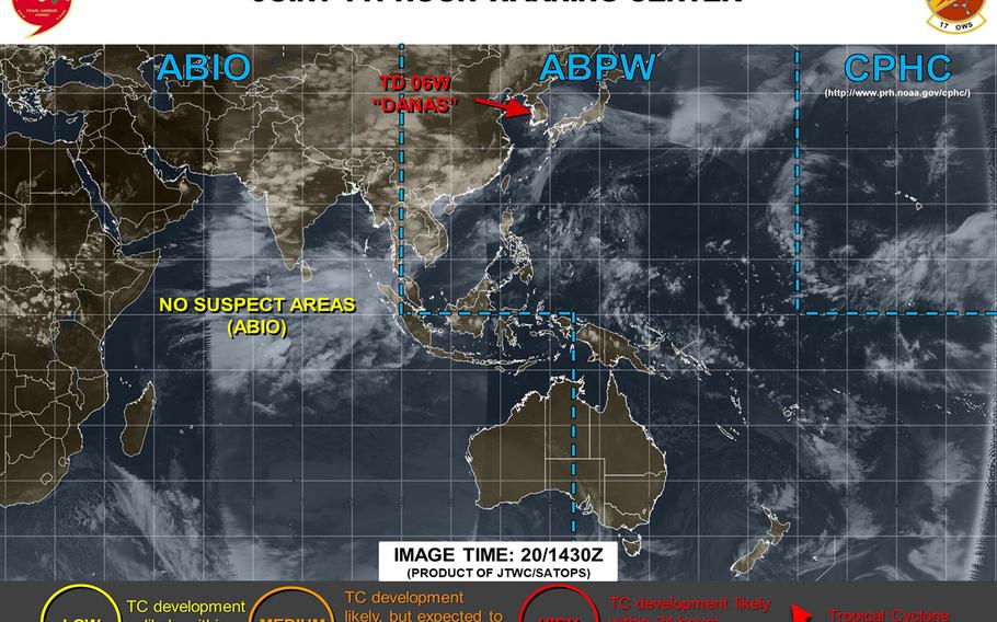
At 11:45 p.m., 98W Invest, known as Falcon PH in the Philippines, was 682 miles south-southeast of Kadena Air Base, Okinawa, moving slowly northwest. U.S. bases on Okinawa remain in seasonal Tropical Cyclone Condition of Readiness 4 and the island still appears to be out of harm’s way, for now.
The Joint Typhoon Warning Center continues to list 98W as a “medium” area https://www.metoc.navy.mil/jtwc/products/abpwweb.txt , with development into a tropical cyclone likely, but not within the next 24 hours.
Kadena’s extended weather forecast https://www.kadena.af.mil/Agencies/Local-Weather/ continues to call for winds picking up Thursday and peaking on Thursday, southeasterly at 25 mph with 35-mph gusts and up to 70-percent chance of showers and scattered thunderstorms.
PAGASA’s forecast track shows 98W peaking as a tropical storm Tuesday and Wednesday evening, taking it past Luzon’s northeast coast through the Luzon Strait, past Taiwan’s southwest coast and into southeastern China overnight Thursday into Friday.
Model track guidance continues to remain spread, with the GFS forecast ensembles favoring tracks toward Taiwan and southeastern China, and the CMC ensembles depicting a more northerly track west of Okinawa. Stay tuned.
2:30 p.m. Monday, July 15, Philippines time: 98W Invest has been upgraded to a "medium" area by the Joint Typhoon Warning Center, meaning development into a tropical cyclone is likely but not within the next 24 hours. U.S. bases on Okinawa appear to be out of the line of fire at the moment. Central to northern Luzon remains 98W's most likely target should it develop into a significant tropical cyclone, according to the Philippines' national weather authority PAGASA. At 2:15 p.m., 98W was 785 miles south-southeast of Kadena Air Base, Okinawa, and 960 miles southeast of Taipei, Taiwan and headed slowly northwest. U.S. bases on Okinawa remain in seasonal Tropical Cyclone Condition of Readiness 4. PAGASA has designated 98W as Tropical Depression FalconPH, and reports that tropical cyclone warning signals may be raised for northern Luzon by Tuesday morning. Kadena's 18th Wing Weather Flight's long-range forecast calls for winds to start picking up Tuesday and peaking Thursday, southeasterly winds up to 25 mph with 35-mph gusts and 70-percent chance of showers and scattered thunderstorms. Significant spreads remain among model track guidance, GFS and CMC ensembles, with some solutions taking 98W into southeastern China and others into southwestern Japan. Too soon to tell specifically what 98W might do. Stay tuned.3:30 a.m. Monday, July 15, Philippines time: Although 98W Invest is still developing and with a vast spread in model solutions, it appears as if Luzon, the Philippines' northernmost main island, might be the likely target should 98W develop into a tropical cyclone. Joint Typhoon Warning Center issued an advisory on 98W just before midnight Sunday, and early indications are that 98W could gradually develop into a tropical system over the next two to three days. The Philippines' national weather authority PAGASA has designated 98W as Tropical Depression FalconPH. PAGASA reports that central and northern Luzon could be 98W's target, with between 12 and 20 inches of rain possible. At 10 p.m. Sunday, 98W was 630 miles west of Guam and forecast to track west-northwest over the coming days. Model track guidance remains spread, as do the GFS and CMC forecast ensembles. Stay tuned.7 p.m. Sunday, July 14, Philippines time: 98W Invest continues to remain about 400 miles west of Guam and 250 miles north of Palau, developing gradually. Initial model track guidance depicts a path toward the Luzon Strait. The Global Forecast System’s best track shows it moving toward southern Taiwan, but with a vast spread among model solutions in the long term.
