()
2 p.m. Monday, Sept. 18, Japan time: Misawa Air Base issued Tropical Cyclone Condition of Readiness All Clear at 2 p.m., with Tropical Talim continuing on its quick path north out of Hokkaido and just east of Sakhalin Island in Russia. This is Pacific Storm Tracker's last report on Talim. Maximum wind gusts at Misawa were 57 mph, according to the base's weather flight.12:30 p.m. Monday, Sept. 18, Japan time: Though Tropical Storm Talim is rapidly hurtling over Hokkaido and out of Japan, Tropical Cyclone Condition of Readiness 1 remains in place at Misawa Air Base and TCCOR Storm Watch for the Kanto Plain. A high-wind warning remains in place at Fleet Activities Yokosuka. Point being, this isn't over yet. Dangerous winds still lurking out there.6 a.m. Monday, Sept. 18, Japan time: Shelter in place, destructive winds of 58 mph or greater, no school due to tropical weather. All terms very unusual for Misawa Air Base in northeastern Japan, not normally an area that is used to seeing tropical cyclones.
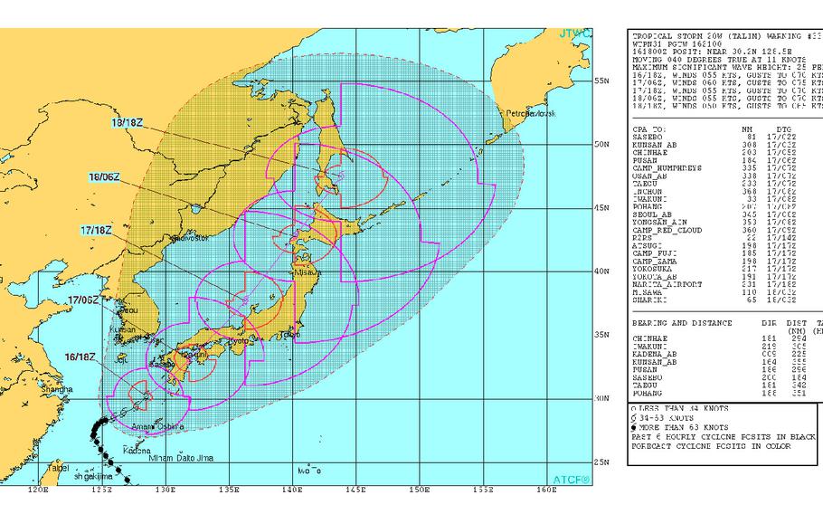
Yet that’s the case for the Tohoku Region of Japan this Monday morning. Misawa is in Tropical Cyclone Condition of Readiness 1. That’s because while Talim continues transitioning from tropical storm to cold-core-low, it is forecast by the Joint Typhoon Warning Center to retain its base of heavy winds and rain as it tracks well north of Japan and east of Russia’s Sakhalin Island in the next two days.
Talim is forecast to pass 45 miles west-northwest of Misawa at about 10 a.m. According to Misawa Weather Flight’s official Facebook page, winds of 58 mph or greater are forecast between 9 a.m. and 3 p.m., with gusts up to 69 mph forecast between 9 a.m. and 5 p.m. Upgrade to TCCOR 1-E – only the second time in Misawa’s history – is possible between these hours. Two to three inches of rain is also forecast.
So, stay put. Don’t go out unless you absolutely must; mission-essential folks are the only ones authorized to be outside, according to Misawa’s official Facebook page.
The only time Misawa has seen such conditions previously was last summer, due to Typhoon Lionrock.
6 p.m. Sunday, Sept. 17, Japan time: Talim is forecast to remain a signifiicant tropical storm, but has begun accelerating and is passing Marine Corps Air Station Iwakuni much further south than previously forecast. At 3 p.m., Talim was 131 miles south of Iwakuni, racing northeast at 23 mph with 63-mph sustained winds and 81-mph gusts at center. Talim is forecast to pass 70 miles east-southeast of Iwakuni early Sunday evening and maintain that strength. Iwakuni remains in Tropical Cyclone Condition of Readiness Storm Watch, as do most U.S. bases in the Kanto Plain. Talim is forecast to pass 184 miles northwest of Yokota Air Base early Monday morning as Talim heads out over the Sea of Japan. Yokosuka Naval Base and its properties are facing a gusty, rainy Sunday evening and Monday morning, the base's weather station said on its official Web site. Wings gusting up to 52 mph late into the evening, peaking at 40- to 46-mph sustained winds and 58-mph gusts around midnight, tapering off as morning comes. Misawa Air Base, well north, isn't out of the woods yet. The base is in TCCOR 2, according to Misawa Weather Flight's official Facebook page. Talim is forecast to pass 91 miles northwest of Misawa at noon Monday.4:30 p.m. Sunday, Sept. 17, Japan time: Fleet Activities Sasebo has issued Tropical Cyclone Condition of Readiness All Clear.3:20 p.m. Sunday, Sept. 17, Japan time: Fleet Activities Sasebo has entered Tropical Cyclone Condition of Readiness 1-C (caution). Winds between 40 and 57 mph are occurring at Sasebo Naval Base and its satellite properties.Time to stay indoors; only emergency essential folks permitted out and about, off or on base. Marine Corps Air Station Iwakuni, Camp Zama and Fleet Activities Yokosuka and its satellite properties remain in TCCOR Storm Watch, while Naval Air Facility Atsugi remains in TCCOR 4.Noon Sunday, Sept. 17, Japan time: Tropical Storm Talim is making landfall over south portions of Kyushu island in southwestern Japan, has dumped more than 20 inches of rain in portions of Miyazaki prefecture in southeastern Kyushu and remains a powerful tropical storm as it powers its way ashore.
At 9 a.m., Talim was 138 miles south of Sasebo Naval Base, moving northeast at 16 mph with 63-mph sustained winds and 81-mph gusts at center. It’s due to retain that strength as it passes 95 miles south-southeast of Sasebo about 1 p.m. Sunday, then 42 miles south-southeast of Marine Corps Air Station Iwakuni about five hours later, accelerating through both areas rather quickly.
Fleet Activities Sasebo remains in Tropical Cyclone Condition of Readiness 1 and Iwakuni in TCCOR Storm Watch.
6 a.m. Sunday, Sept. 17, Japan time: U.S. bases on Okinawa have reverted to seasonal Tropical Cyclone Condition of Readiness 4, while Fleet Activities Sasebo remains in TCCOR 1 and Marine Corps Air Station Iwakuni in TCCOR Storm Watch in advance of Tropical Storm Talim.
At 3 a.m., Talim was 212 miles south-southwest of Sasebo Naval Base, moving northeast at 13 mph with sustained 63-mph winds and 81-mph gusts at center. Joint Typhoon Warning Center projects Talim to intensify slightly as it heads ashore by mid-morning Sunday.
JTWC forecasts Talim to pass 93 miles south-southeast of Sasebo at 11 a.m. and 38 miles south-southeast of Iwakuni six hours later as a severe tropical storm. Stay tuned to PST, Sasebo’s and Iwakuni’s official Facebook pages and commanders’ access channels for more.
11:30 p.m. Saturday, Sept. 16, Japan time: Joint Typhoon Warning Center's latest forecast track on Tropical Storm Talim takes it slightly further east of Sasebo Naval Base and Marine Corps Air Station Iwakuni than previously reported. If Talim continues to move as forecast, it should pass 117 miles south-southeast of Sasebo at 11 a.m. Sunday and 60 miles south-southeast of Iwakuni six hours later, possibly as a Category 1-equivalent storm, most certainly as a severe tropical storm. At 9 p.m., Talim was 280 miles south-southwest of Sasebo, moving northeast at 12 mph with 63-mph sustained winds and 81-mph gusts at storm's center.9:30 p.m. Saturday, Sept. 16, Japan time: Marine Corps Air Station Iwakuni has entered Tropical Cyclone Condition of Readiness Storm Watch. The base's official Facebook page states that Tropical Storm Talim is due to pass 46 miles south-southeast of Iwakuni late Sunday afternoon, with 35-mph sustained winds and 54-mph gusts forecast along with 2-to-3 inches of rain. Fleet Activities Sasebo remains in TCCOR 1; expect that to upgrade sometime early Sunday. U.S. bases on Okinawa remain in TCCOR Storm Watch.8:45 p.m. Saturday, Sept. 16, Japan time: Fleet Activities Sasebo has set Tropical Cyclone Condition of Readiness 1. Destructive winds of 58 mph or greater are anticipated within 12 hours. Stay tuned to PST, CFAS' official Facebook page or CFAS' command access TV channel for updated information. At 3 p.m., Tropical Storm Talim was 340 miles south-southwest of Sasebo Naval Base, moving east-northeast at 9 mph, packing 69-mph sustained winds and 86-mph gusts at storm's center. Talim is forecast to pass 113 miles south-southeast of Sasebo at high noon Sunday, possibly as a Category 1-equivalent typhoon. Five hours later, Talim is due to pass 46 miles south-southeast of Marine Corps Air Station Iwakuni, still maintaining Category 1-equivalent force. MCAS Iwakuni remains in TCCOR 3; that may change rather rapidly overnight into Sunday. Time to prepare. Get your safe on!Noon Saturday, Sept. 16, Japan time: Talim has been downgraded to a tropical storm by the Joint Typhoon Warning Center, but remains on track to pass close to Sasebo Naval Base and Marine Corps Air Station Iwakuni on Sunday morning and afternoon. And it remains a dangerous beast, even if its fiercest winds have diminished. Still time to prepare for the worst. At 9 a.m., Talim was 181 miles northwest of Kadena Air Base, Okinawa, and starting to pick up forward speed, moving east-northeast at 7 mph with 69-mph sustained winds and 86-mph gusts at center. U.S. bases on Okinawa remain in Tropical Cyclone Condition of Readiness Storm Watch. If Talim continues on its present course, it's projected to pass 90 miles south-southeast of Sasebo at 11 a.m. Sunday. Talim is forecast to remain a strong tropical storm as it makes landfall over Kyushu in southwestern Japan at mid-morning. Fleet Activities Sasebo remains in TCCOR 2 and is expected to enter TCCOR 1 at 4 p.m. Saturday, according to the CFAS official Facebook page. Talim next is due to pass 40 miles south-southeast of Iwakuni at 5 p.m. Sunday, and still as a strong tropical storm, 63-mph sustained winds and 81-mph gusts at center. Iwakuni remains in TCCOR 3. All that could change, depending on Talim's intensity and proximity to each base. Talim appears to be tracking well out of the Kanto Plain and Misawa Air Base's range, but PST will keep an eye on that for any changes as well.12:15 a.m. Saturday, Sept. 16, Japan time: Typhoon Talim continues to lose power while it slowly creeps northeast, remaining on a track that should have it sideswipe Sasebo Naval Base and Marine Corps Air Station Iwakuni with Category 1-equivalent or severe tropical storm force.
At 9 p.m., Talim was 188 miles northwest of Kadena Air Base, Okinawa, edging northeast at 6 mph with 86-mph sustained winds and 104-mph gusts at center. Talim should retain that intensity as it barrels toward Kyushu in southwestern Japan with forecast arrival now at mid-morning Sunday.
If Talim continues moving as forecast, it should pass 86 miles southeast of Sasebo at 9 a.m. Sunday, still as a Category 1-equivalent typhoon. Fleet Activities Sasebo remains in TCCOR 2; that should change by mid-morning Saturday. It should then pass Iwakuni seven hours later, 45 miles southeast. Iwakuni remains in TCCOR 3, which should also change sometime Saturday afternoon.
6:40 p.m. Friday, Sept. 15, Japan time: Typhoon Talim has begun tracking northeast and is forecast to maintain 92-mph sustained winds and 115-mph gusts over the next day and a half as it makes its way toward Kyushu in southwestern Japan, according to the Joint Typhoon Warning Center. At 3 p.m., Talim was 196 miles west-northwest of Kadena Air Base, Okinawa, traveling east-northeast at 7 mph. Talim is not forecast to approach Okinawa, but pass it some 184 miles north-northwest at 5 a.m. Saturday. If Talim continues to move as JTWC forecasts, it's due to pass 96 miles south-southeast of Sasebo Naval Base at 11 a.m. Sunday, then 45 miles south-southeast of Marine Corps Air Station Iwakuni about six hours later, still as a severe tropical storm, 69-mph sustained winds and 86-mph gusts at center.
6:20 p.m. Friday, Sept. 15, Japan time: Your updated TCCOR scoreboard as of 6 p.m.:
U.S. bases on Okinawa: Tropical Cyclone Condition of Readiness Storm Watch. Fleet Activities Sasebo: TCCOR 2 as of 9 a.m. Friday. Marine Corps Air Station Iwakuni: TCCOR 3 as of 1 p.m. Friday.Fleet Activities Sasebo announced on its official Facebook page further TCCOR accelerations:
TCCOR 1: 5 p.m. Saturday. TCCOR 1-C (caution): 3 a.m. Sunday. TCCOR 1-E (emergency): 5 a.m. Sunday. TCCOR 1-R (recovery), 3 p.m. Sunday. TCCOR All-Clear: To be determined.Please note that all of those are subject to change, based on storm movement, intensity and proximity to Sasebo Naval Base.
1 p.m. Friday, Sept. 15, Japan time: Fleet Activities Sasebo has set Tropical Cyclone Condition of Readiness 2. Destructive winds of 58 mph or greater are anticipated within 24 hours.
1 p.m. Friday, Sept. 15, Japan time: Talim has continued to weaken, down to Category 1-equivalent status, and has begun curving northeast en route to forecast rendezvous with Kyushu in southwestern Japan early Sunday morning, according to the Joint Typhoon Warning Center. At 9 a.m., Talim was 222 miles west-northwest of Kadena Air Base, Okinawa, headed north-northeast at 4 mph with sustained 92-mph winds and 115-mph gusts at center. U.S. bases remain in Tropical Cyclone Condition of Readiness Storm Watch. Sasebo Naval Base remains in TCCOR 3 and Marine Corps Air Station Iwakuni in TCCOR 4; expect upgrades to those sometime later Friday or early Saturday./ If Talim continues moving as forecast, it should pass 97 miles south-southeast of Sasebo at 8 a.m. Sunday as a severe tropical storm, 69-mph sustained winds and 86-mph gusts at storm's center. Talim should next pass 46 miles south-southeast of Iwakuni at 3 p.m. Sunday and move rather rapidly out of the area northeast.
6:20 a.m. Friday, Sept. 15, Japan time:Typhoon Talim has slowed a bit in its turn northeast and has continued to weaken some, now a Category 2-equivalent storm, and is due to pass Sasebo Naval Base and Marine Corps Air Station Iwakuni a bit later than previously forecast.
At 3 a.m., Talim was 225 miles west-northwest of Kadena Air Base, Okinawa, crawling north at 6 mph with 110-mph sustained winds and 132-mph gusts at center. U.S. bases on Okinawa remain in Tropical Cyclone Condition of Readiness Storm Watch. The typhoon warning for Taiwan has been canceled, according to the island’s Central Weather Bureau.
If Talim continues moving as forecast, it should remain a Category 1-equivalent typhoon as it rams ashore over Kyushu, in southwestern Japan, at 3 a.m. Monday, passing 76 miles south-southeast of Sasebo a couple of hours later. Talim should then pick up forward speed, passing Iwakuni seven hours later as a severe tropical storm. Sasebo remains in TCCOR 3 and Iwakuni in TCCOR 4; expect those to be upgraded later Friday.
U.S. bases in the Kanto Plain remain out of harm’s way; Talim is forecast to pass 225 miles northwest of Yokota Air Base at 1 a.m. Monday. And Talim is due to pass a bit further northwest of Misawa Air Base, than previously forecast, 100 miles 1 p.m. Monday.
Midnight Thursday, Sept. 14, Japan time: Typhoon Talim has begun losing its punch, diminishing to a Category 3-equivalent storm, 127-mph sustained winds and 155-mph gusts at center. But it has remained close enough to Okinawa to warrant a new closet point of approach, according to the Joint Typhoon Warning Center.
At 9 p.m., Talim was 215 miles west-northwest of Kadena Air Base and has become quasi-stationary in the last six hours. Talim is due to start curving northeast, forecast to pass about 210 miles northwest of Kadena at 1 a.m. Saturday – close enough that windbands, along with accompanying gusts and showers, heavy at times, may linger into the weekend.
U.S. bases on Okinawa remain in Tropical Cyclone Condition of Readiness Storm Watch. Further northeast, Sasebo Naval Base remains in TCCOR 3 and Marine Corps Air Station Iwakuni in TCCOR 4.
If Talim continues tracking as forecast, it’s due to pass 94 miles south-southeast of Sasebo at 5 a.m. Sunday as a Category 1-equivalent typhoon, 86-mph sustained winds and 104-mph gusts at storm’s center. It’s then projected to pass 50 miles south-southeast of Iwakuni seven hours later, remaining a typhoon as it roars past.
U.S. bases in the Kanto Plain are forecast to remain out of harm’s way, Talim passing 180 miles northwest of Yokota Air Base at 1 a.m. Monday. Talim is then forecast to track rapidly northeast, remaining a strong tropical storm as it rumbles 51 miles northwest of Misawa Air Base at 11 a.m. Monday.
9:10 p.m. Thursday, Sept. 14, Japan time: Marine Corps Air Station Iwakuni in southwestern Japan has set Tropical Cyclone Condition of Readiness 4. Destructive winds of 58 mph or greater possible within 72 hours.
6:30 p.m. Thursday, Sept. 14, Japan time: Unless something changes, Typhoon Talim has peaked as a Category 4-equivalent storm, 138-mph sustained winds and 167-mph gusts at center as it lurks between Okinawa and Taiwan, getting set to rumble toward Kyushu in southwestern Japan, according to the Joint Typhoon Warning Center. At 3 p.m., Talim was 220 miles west-northwest of Kadena Air Base, churning north-northwest at 7 mph. U.S. bases on Okinawa remain in Tropical Cyclone Condition of Readiness Storm Watch; Fleet Activities Sasebo remains in TCCOR 3; expect that to be upgraded Friday afternoon. If Talim remains on its present course, it should begin losing its punch as it passes 84 miles south-southeast of Sasebo Naval Base at 3 a.m. Sunday, still as a Category 2-equivalent typhoon. It should then pass 42 miles south-southeast of Marine Corps Air Station Iwakuni as a Category 1-equivalent storm. The Kanto Plain should remain well out of harm's way. JTWC projects Talim to pass 83 miles northwest of Misawa Air Base at mid-morning Monday as a severe tropical storm.
3 p.m. Thursday, Sept. 14, Japan time: Fleet Activities Sasebo has set Tropical Cyclone Condition of Readiness 3 at 3 p.m. Destructive winds of 58 mph or greater are possible within 48 hours.
12:15 p.m. Thursday, Sept. 14, Japan time: Talim continues to intensify, remains forecast over the next couple of days to peak as a Category 4-equivalent typhoon and its latest projected track takes it slightly closer to Sasebo Naval Base and Marine Corps Air Station Iwakuni, according to the Joint Typhoon Warning Center.
At 9 a.m., Talim was about 200 miles west of Kadena Air Base, Okinawa, headed north-northwest at 8 mph, beginning its long slow turn northeast toward Kyushu in southwestern Japan. Talim’s intensity has increased to 132-mph sustained winds and 161-mph gusts. It’s forecast to peak at 138-mph sustained winds and 167-mph gusts at mid-evening Thursday and remain that strong through Friday.
U.S. bases on Okinawa remain in Tropical Cyclone Condition of Readiness Storm Watch. No accelerated TCCORs have been posted at Sasebo or Iwakuni, yet; expect that to change as weekend approaches.
As Talim curves northeast, it’s forecast to pass 91 miles south-southeast of Sasebo, a tad closer than last reported, at 8 a.m. Sunday, and 39 miles south-southeast of Iwakuni at mid-afternoon, and still as a Category 1-equivalent storm.
With that track change, Talim is also due to pass much further north of the Kanto Plain, out in the Sea of Japan, about 210 miles northwest of Yokota Air Base early Monday morning. As Talim weakens and moves more rapidly northeast, it’s forecast to pass 71 miles northwest of Misawa Air Base at mid-afternoon Monday.
7:45 a.m. Thursday, Sept. 14, Japan time: Talim continues to strengthen and remains on track to pass close to Sasebo Naval Base and Marine Corps Air Station Iwakuni, forecast to remain a strong typhoon as it roars past, according to the Joint Typhoon Warning Center.
At 3 a.m., Talim was 183 miles west of Kadena Air Base, heading northwest at 7 mph and had continued steadily intensifying, 121-mph sustained winds and 150-mph gusts at center. If Talim continues moving as forecast, it’s due to peak at Category 4-equivalent strength, 143-mph sustained winds and 172-mph gusts by early Friday morning.
While Taiwan and Okinawa should escape Talim’s full wrath, expect gusty, showery conditions through Friday afternoon on Okinawa, according to Kadena’s Shogunweather.com weather web site. U.S. bases on Okinawa remain in Tropical Cyclone Condition of Readiness Storm Watch. Southwest portions of Okinawa can expect gusts up to 63 mph at mid-day Thursday.
Talim should continue heading northwest, then begin curving northeast by Friday, tracking toward the southern edges of Kyushu island in southwestern Japan.
JTWC projects Talim to make landfall near Miyazaki and Kagoshima by early Sunday morning, passing 121 miles south-southeast of Sasebo at 7 a.m. Sunday, still packing 110-mph sustained winds and 132-mph gusts at center. Talim is forecast to pass even closer to Iwakuni, 69 miles south-southeast about eight hours later.
Talim should miss U.S. bases in the Kanto Plain by a good 170 miles or so, but could remain a strong tropical storm as it passes 30 miles northwest of Misawa Air Base early Monday afternoon.
11:30 p.m. Wednesday, Sept. 13, Japan time: Kyushu and Iwakuni are next on Typhoon Talim's travel itinerary. Could the Kanto Plain, and perhaps even Misawa, be next?
At 9 p.m., Talim was 170 miles west-southwest of Kadena Air Base, Okinawa, headed north-northwest at 7 mph, slowing down enough over warm waters that it has intensified rapidly over the last six hours -- 104-mph sustained winds and 127-mph gusts at center.
Talim remains forecast to head north-northwest over the next day or so before turning sharply east-northeast, peaking as a Category 4-equivalent typhoon, 132-mph sustained winds and 161-mph gusts at mid-evening Friday, before turning its attention to southwestern Japan.
Talim is due to pass 116 miles south-southeast of Sasebo Naval Base at 5 a.m. Sunday, remaining a Category 2-equivalent storm, 110-mph sustained winds and 132-mph gusts as it passes.
Next is Marine Corps Air Station Iwakuni. Talim is forecast to pass 82 miles south-southeast of there at noon Sunday, and still as a potent Category 1-equivalent typhoon, perhaps Category 2.
Could it remain a typhoon as it passes the Kanto Plain? Talim is projected to head 131 miles northwest of Yokota Air Base at 1 a.m. Monday, still as a typhoon.
Even Misawa Air Base could receive some of Talim's wrath. It's forecast to remain a severe tropical storm, 58-mph sustained winds and 75-mph gusts as it makes a near-direct hit on the base. We shall see.
U.S. bases on Okinawa remain in Tropical Cyclone Condition of Readiness Storm Watch, just in case. A typhoon warning remains in effect for Taiwan by the Central Weather Bureau. No upgraded TCCORs have been issued yet for bases in Japan.
7 p.m. Wednesday, Sept. 13, Japan time: Typhoon Talim has made its closest point of approach to Okinawa (for now), with maximum winds of 39-mph sustained and 56-mph gusts recorded earlier Wednesday.
Gusty winds, rainshowers and thunderstorms, some heavy at times, remain in the offing the next couple of days as Talim's back-side nastiness still assaults the island from afar.
At 3 p.m., Talim was centered 167 miles southwest of Kadena Air Base, headed northwest at 10 mph, holding steady at 86-mph sustained winds and 104-mph gusts at center.
U.S. bases on Okinawa remain in Tropical Cyclone Condition of Readiness Storm Watch. A typhoon warning remains in effect for Taiwan, though Talim is forecast to pass 208 miles northeast of Taipei, the island's capital, at 6 a.m. Thursday. local time.
From there, Talim is due to head north, peaking at Category 3-equivalent strength, 127-mph sustained winds and 155-mph gusts at mid-afternoon Friday, just as it turns northeast and heads toward Kyushu in southwestern Japan.
Talim is forecast to pass 104 miles south-southeast of Sasebo Naval Base at 5 a.m. Sunday, then 76 miles south-southeast of Marine Corps Air Station Iwakuni, remaining a Category 1-equivalent typhoon as it dashes by.
1 p.m. Wednesday, Sept. 13, Japan time: Typhoon Talim's latest forecast track has edged slightly closer to Okinawa, with a new closest-point-of-approach now forecast for 2 p.m., 167 miles south-southwest of Kadena Air Base. U.S. bases on Okinawa remain in Tropical Cyclone Condition of Readiness Storm Watch.
At 9 a.m., Talim was 173 miles south-southwest of Kadena, tracking northwest at 12 mph with 86-mph sustained winds and 104-mph gusts at center. Okinawa has begun experiencing 40-mph sustained winds and 52-mph gusts, which should continue through early Thursday morning, according to Kadena's Shogunweather.com.
Model guidance remains spread, though most models agree on a sharp northeast turn, with Talim peaking as a Category 4-equivalent typhoon, 132-mph sustained winds and 161-mph gusts, before plowing ashore over Kyushu early Sunday morning.
Talim is forecast to pass 113 miles south-southeast of Sasebo Naval Base at 7 a.m. Sunday as a Category 1-equivalent storm. It should next pass 89 miles south-southeast of Marine Corps Air Station Iwakuni about nine hours later as a severe tropical storm. No TCCORs have been issued at either locale yet.
8 a.m. Wednesday, Sept. 13, Japan time: Expect a mid-week on Okinawa filled with gusty winds, showers and thunderstorms https://shogunweather.com/ thanks to Typhoon Talim. As the weekend approaches, Kyushu can expect pretty much the same treatment, according to the Joint Typhoon Waring Center’s latest forecast track.
At 3 a.m., Talim was 197 miles south-southwest of Kadena Air Base, headed northwest at 14 mph, holding steady at 81-mph sustained winds and 98-mph gusts. If Talim continues on its current path, closest point of approach should be 181 miles southwest at 9 a.m. U.S. bases on Okinawa remain in Tropical Cyclone Condition of Readiness Storm Watch.
Taiwan should escape Talim’s full fury, JTWC reports. It should pass 181 miles northeast of Taipei, the island’s capital, at 4 a.m. Thursday local time. A typhoon warning remains in effect for Taiwan, according to its Central Weather Bureau.
Talim remains forecast to peak at Category 3-equivalent force, 127-mph sustained winds and 155-mph gusts Friday into Saturday as it curves sharply northeast toward Kyushu, then lose some of its punch as it rams ashore, passing 95 miles south-southeast of Sasebo Naval Base at 7 a.m. Sunday as a Category 1-equivalent storm. It should pass 71 miles south-southeast of Marine Corps Air Station Iwakuni eight hours later as a severe tropical storm.
11:45 p.m. Tuesday, Sept. 12, Japan time: Typhoon Talim has slowed somewhat in its journey northwest. It’s still forecast to sideswipe Taiwan to its northeast, then curve sharply northeast and slam ashore by mid-morning Sunday over Kyushu in southwestern Japan, according to the Joint Typhoon Warning Center.
At 9 p.m., Talim was about 250 miles south of Kadena Air Base, Okinawa, moving northwest at 13 mph and has intensified slightly, to 81-mph sustained winds and 98-mph gusts at center. If it continues moving as forecast, Talim should pass 206 miles south-southwest of Kadena at 9 a.m. Wednesday, with Okinawa right on the edge of Talim’s forecast 34-knot (40-mph) wind bands. U.S. bases on Okinawa remain in Tropical Cyclone Condition of Readiness Storm Watch, according to Shogunweather.com
Talim remains on course to miss Taiwan to its northeast, passing 155 miles northeast of Taipei, the island’s capital, at 3 a.m. Thursday, before curving northeast. A typhoon warning remains in effect for Taiwan, according to the country’s Central Weather Bureau. JTWC projects Talim to peak as a Category 3-equivalent typhoon, 127-mph sustained winds and 155-mph gusts at mid-morning Thursday.
That curve northeast should occur rather rapidly overnight Thursday into Friday, with Okinawa feeling some effects of Talim’s southern quadrants into the weekend. JTWC projects Talim to pass 94 miles south-southeast of Sasebo Naval Base at about mid-morning Sunday, still as a Category 1-equivalent typhoon. Talim should next pass 79 miles south-southeast of Marine Corps Air Station Iwakuni as a severe tropical storm.
8:15 p.m. Tuesday, Sept. 12, Japan time: Typhoon Talim remains a strong Category 1-equivalent storm, is due to peak at high Category 3-equivalent force, curve sharply northeast Friday afternoon and possibly put Kyushu in southwestern Japan in its crosshairs.
Joint Typhoon Warning Center's latest track shows Talim packing 75-mph sustained winds and 92-mph gusts. At 3 p.m., Talim was 295 miles south of Kadena Air Base, Okinawa, moving west-northwest at 23 mph. U.S. bases on Okinawa remain for the moment in Tropical Cyclone Condition of Readiness Storm Watch.
If Talim continues moving as forecast, it should pass 213 miles southwest of Kadena at about 7 a.m. Wednesday. Kadena's 18th Wing Weather Flight's Shogunweather.com projects the following wind forecast timeline for Okinawa.
40-mph sustained winds or greater: 5 a.m. Wednesday. Peak 46-mph sustained winds, 58-mph gusts for Kadena: 10 a.m. Wednesday. Winds diminishing below 40-mph sustained: 6 a.m. Thursday.Even then, it might not be over for southwestern Japan. JTWC projects Talim to miss Taiwan to the northeast, 146 miles northeast of Taipei, the capital, at 2 a.m. Taiwan time Thursday. At that point, JTWC projects Talim to be packing peak 127-mph sustained winds and 155-mph gusts at center. A typhoon warning has been issued for Taiwan by the Central Weather Bureau.
That sharp right northeast turn is projected for mid-afternoon Friday, and Talim is then forecast to barrel through Kyushu in southwestern Japan early Sunday morning.
Talim is forecast to pass 85 miles south-southeast of Sasebo Naval Base at 1 a.m. Sunday, still as a Category 1-equivalent typhoon. Next up is Marine Corps Air Station Iwakuni; Talim is due to pass 82 miles south-southeast of Iwakuni at mid-morning Sunday as a severe tropical storm.
Noon Tuesday, Sept. 12, Japan time: Talim has been upgraded to a Category 1-equivalent typhoon by the Joint Typhoon Warning Center. While not forecast to directly impact Okinawa, Talim's latest track brings it ever closer to the island -- and it could impact Kyushu in southwestern Japan by the weekend.
At 9 a.m., Talim was 388 miles south-southeast of Kadena Air Base, headed northwest at 18 mph, 75-mph sustained winds and 92-mph gusts at center. U.S. bases on Okinawa remain in Tropical Cyclone Condition of Readiness Storm Watch, which was issued by 18th Wing command at 9:33 a.m.
If it remains on its current path, Talim is forecast to pass 202 miles southwest of Kadena at 7 a.m. Wednesday, with southwestern portions of Okinawa inside Talim's forecast 34-knot (40-mph) wind bands.
Long-range weather forecast at Shogunweather.com projects between 60- and 70-percent chance of showers and thunderstorms, with winds peaking at 27-mph sustained with 41-mph gusts as Talim passes south of Okinawa.Taiwan and the Philippines appear to be more out of harm's way than previously forecast.
Talim is forecast to peak at Category 4-equivalent strength, 132-mph sustained winds and 161-mph gusts, as it bends northeast of Taiwan into Thursday morning. No warnings have been issued by Taiwan's Central Weather Bureau. Talim is forecast to pass 130 miles north-northeast of Taipei, the island's capital, at 3 a.m. Thursday Taiwan time.
Model guidance remains spread. It's generally agreed that Talim won't directly impact southeastern China, but GFS ensemble and CMC ensemble both suggest a more direct impact on Okinawa and Japan's main islands, which would be a first for the season. This one bears close watching.
11 a.m. Tuesday, Sept. 12, Japan time: U.S. bases on Okinawa have entered Tropical Cyclone Condition of Readiness Storm Watch. Though Talim is not forecast to threaten Okinawa directly, as a precaution, readiness condition has been upgraded, in case the track changes.
5:30 p.m. Monday, Sept. 11, Taiwan time: Talim is approaching Category 1-equivalent typhoon strength, has picked up forward speed and continues on a course taking it well south of Okinawa while possibly putting Taipei in its sights, according to the Joint Typhoon Warning Center’s latest forecast track.
At 2 p.m., Tropical Storm Talim was 685 miles southeast of Kadena Air Base, steaming west-northwest at 18 mph, 69-mph sustained winds and 86-mph gusts at center. JTWC projects Talim to peak at just below Category 4-equivalent strength, 127-mph sustained winds and 155-mph gusts at center before plowing ashore over northeastern Taiwan early Thursday morning.
If it remains on its current track, Talim is due to pass 8 miles south-southwest of Taipei at about 4 a.m. Thursday, emerge back over the Formosa Strait, then make secondary landfall over southeastern China at mid-afternoon Thursday. Okinawa should be well out of harm’s way; JTWC depicts Talim passing 285 miles south-southwest of Kadena at 1 a.m. Wednesday.
Model guidance agrees that Talim should curve north and northeast; the question being when and where? GFS ensemble suggests a hard right turn after Talim brushes the Chinese coast, then barrel northeast toward Japan; CMC ensemble forecasts a turn much earlier, before even reaching Taiwan, and curving toward Okinawa.
No watches or warnings have been issued yet for Taiwan by its Central Weather Bureau. U.S. bases on Okinawa remain in seasonal Tropical Cyclone Condition of Readiness 4, according to Kadena’s 18th Wing Weather Flight’s official Web site Shogunweather.com.
Meanwhile, in the Philippines, a low-pressure area was designated a tropical depression by the country's weather authority PAGASA and has been named Maring. Tropical Cyclone Warning Signal 1 has been issued for areas of central Luzon island.
10 p.m. Sunday, Sept. 10, Taiwan time: Slight adjustment to Tropical Storm Talim’s forecast track, now taking the 20th numbered storm of the northwest Pacific’s tropical cyclone season through the heart of Taiwan sometime early Thursday morning, according to the Joint Typhoon Warning Center.
At 8 p.m., Talim was 500 miles northwest of Andersen Air Force Base, Guam, moving west-northwest at 13 mph, holding steady at 46-mph sustained winds and 58-mph gusts.
If Talim continues moving as forecast, it will bisect Taiwan, passing 92 miles north-northeast of Kaohsiung and 93 miles south-southwest of Taipei, the island’s capital, between 4 and 7 a.m. Thursday as a Category 1-equivalent typhoon, 86-mph sustained winds and 104-mph gusts at center. Talim is forecast to peak as a Category 3-equivalent typhoon before reaching landfall.
Models continue to disagree: GFS ensemble projects a curve back out over water after making landfall over southeastern China by next weekend. CMC ensemble has Talim brushing Taiwan’s northeast coast before turning northeast, west of Okinawa, and toward the Tsushima Strait between Korea and southwestern Japan.
12:30 p.m. Sunday, Sept. 10, Taiwan time: Tropical Storm Talim continues tracking well west of the Marianas Islands, and the latest Joint Typhoon Warning Center forecast track now takes Talim through central Taiwan as a Category 4-equivalent typhoon by mid-week.
At 11 a.m., Talim was 395 miles west-northwest of Guam, tracking west-northwest at 13 mph with 46-mph sustained winds and 58-mph gusts at center. Talim is forecast to keep tracking west-northwest on a route taking it 56 miles north-northeast of Kaohsiung and 130 miles south-southwest of Taipei, Taiwan’s capital, between 3 and 6 a.m. Thursday. It’s expected to be packing 132-mph sustained winds and 161-mph gusts before making landfall.
Model guidance remains spread. The GFS ensemble has Talim making landfall over southeastern China, then making a sharp right turn northeast toward southwestern Japan. The CMC ensemble still doesn’t have Talim even reaching Taiwan, instead making a 90-degree turn right and trucking north-northeast toward Okinawa and the Tsushima Strait between Korea and Kyushu.
2 a.m. Sunday, Sept. 10, Guam time: Talim has been upgraded to a tropical storm as it continues west out of the Marianas Islands, with the latest Joint Typhoon Warning Center forecast track taking Talim over southern Taiwan and into southeastern China later this week.
At 10 p.m., Talim was 180 miles northwest of Andersen Air Force Base, Guam, headed west-northwest at 11 mph, 40-mph sustained winds and 52-mph gusts at center. If it remains on its present course, Talim is forecast to pass 15 miles south-southwest of Kaohsiung at 7 a.m. Thursday as a Category 4-equivalent typhoon, 132-mph sustained winds and 161-mph gusts at center as it roars past.
Just a matter of where it goes after making landfall over China, if it gets that far. The GFS ensemble still indicates a straight westerly run into southeastern China, while the CMC ensemble indicates a right turn just before Taiwan and heading toward the Tsushima Strait between Korea and southwestern Japan.
7:50 a.m. Saturday, Sept. 9, Guam time: A new tropical depression spawned east of Guam overnight Friday, and the initial Joint Typhoon Warning Center track bears bad news for the northern Philippines and southern Taiwan: 20W is forecast to intensify to super-typhoon strength. At 7 a.m., 20W was 90 miles east of Andersen Air Force Base, headed west at 18 mph, 25-mph sustained winds and 35-mph gusts. According to the National Weather Service on Guam, 20W is forecast to race through the Marianas Islands over the weekend, intensifying into a tropical storm after it passes well west of the islands. JTWC projects 20W peaking as a super typhoon early Thursday morning. Although they generally agree on a west-northwest track toward the Philippines and Taiwan, model guidance disagrees somewhat on actual track and peak intensity. That’s normal at this point in the life of a developing storm. PST is keeping an eye on it.
2 p.m. Friday, Sept. 8, Guam time: A tropical cyclone formation alert has been issued by the Joint Typhoon Warning Center on a disturbance about 750 miles east-southeast of Guam.
Model guidance (GFS ensemble and CMC ensemble) points to the system developing by Saturday or Sunday and tracking west-northwest, toward the Philippines and Taiwan and possibly on toward southeastern China — which has been battered by three such tropical cyclones in the last month. Okinawa may be affected as well. PST has an eye on it.
