As September dawns, a new tropical depression has formed just west of Luzon in the Philippines. ()
7 a.m. Monday, Sept. 4, Hong Kong time: Mawar has been downgraded to a tropical depression after making landfall overnight Sunday. Strong Wind Signal 3 was raised by the Hong Kong Observatory and Mawar has made its closest point of approach early Monday morning, 103 miles northeast. This is PST’s final report on Mawar.
6 p.m. Sunday, Sept. 3, Hong Kong time: Though Tropical Storm Mawar continues on a course taking it about 90 miles northeast of Hong Kong early Monday morning, it might lurch closer and the Hong Kong Observatory may consider issuing Strong Wind Signal 3 sometime Sunday evening.
Standby Signal 1 remains raised for the moment. At 2 p.m., Mawar was 140 miles east of Hong Kong, trudging north-northwest at 5 mph and holding steady at 52-mph sustained winds and 63-mph gusts, according to the Joint Typhoon Warning Center.
Landfall is projected for around midnight Sunday, with Signal 3 to be raised if the track edges closer to Hong Kong and forecast winds increase.
10 a.m. Sunday, Sept. 3, Hong Kong time: Tropical Storm Mawar’s track continues to wobble Sunday; it began zagging west-northwest during the morning, and if it remains on its current path, Mawar should make landfall about 88 miles east of Hong Kong sometime Sunday evening, according to the Joint Typhoon Warning Center.
At 8 a.m., Mawar was 149 miles east of Hong Kong, crawling west-northwest at 5 mph, having peaked at 52-mph sustained winds and 63-mph gusts. Standby Signal 1 remains raised for Hong Kong by the Hong Kong Observatory. Chances of issuing Strong Wind Signal 3 remain low, but if Mawar keeps tracking closer to Hong Kong, that may change later.
11 p.m. Saturday, Sept. 2, Hong Kong time: One thing remains certain about Tropical Storm Mawar: It continues a ponderous, zig-zag walk in the general direction of southeastern China. Question remains: How close will it make landfall to Hong Kong and how much effect will it have on the city?
At 8 p.m., Mawar was 205 miles east-southeast of Hong Kong, crawling due north at 3 mph, holding steady at 52-mph sustained winds and 63-mph gusts. Mawar is forecast to peak at 58-mph sustained winds and 75-mph gusts, then weakening slightly as it makes landfall about 8 p.m. Sunday and passing 136 miles northeast of Hong Kong at about 7 a.m. Monday.
But there remains something of a spread among model guidance, some suggesting an even closer passage to Hong Kong, where Standby Signal 1 remains raised by the Hong Kong Observatory. Chances of issuing Strong Signal 3 remain low, the Observatory continues to state.
5 p.m. Saturday, Sept. 2, Hong Kong time: Tropical Storm Mawar has slowed its pace in the South China Sea, almost as if making up its mind where in particular it plans to make landfall over southeastern China, though most model guidance still says northeast of Hong Kong around mid-day Monday.
At 2 p.m., Mawar was 210 miles east-southeast of Hong Kong, crawling north-northwest at just 2 mph, holding steady at 46 mph sustained winds and 58 mph gusts. Joint Typhoon Warning Center projects Mawar to peak at 52 mph sustained winds and 63-mph gusts sometime early Sunday.
If it remains on its present course, Mawar is projected to pass 130 miles northeast of Hong Kong at noon Monday as a tropical depression after it makes landfall. Standby Signal 1 remains raised by the Hong Kong Observatory; the chances of going to Strong Wind Signal 3 by Sunday morning remain low, the Observatory notes.
7 a.m. Saturday, Sept. 2, Hong Kong time: Standby Signal 1 has been issued by the Hong Kong Observatory in advance of the passage of Tropical Storm Mawar, though the Joint Typhoon Warning Center’s latest track takes Mawar well northeast of the city. HKO states the chances of going to Strong Wind Signal 3 sometime Saturday are low.
At 2 a.m., Mawar was 251 miles east-southeast of Hong Kong, moving north-northwest at 7 mph, holding steady at 40-mph sustained winds and 52-mph gusts. But if it remains on its current track, Mawar should pass 183 miles east-northeast of Hong Kong at 1 a.m. Monday as a tropical depression. JTWC projects Mawar to peak at 52-mph sustained winds and 63-mph gusts at about 2 a.m. Sunday.
11:30 p.m. Friday, Sept. 1, Hong Kong time: The bad news: Mawar has been upgraded to a tropical storm by the Joint Typhoon Warning Center. The good news: It might not intensify into a typhoon and it may well steer clear of Hong Kong after all.
At 8 p.m., Mawar was 281 miles east-southeast of Hong Kong, moving north-northwest at 5 mph with 40-mph sustained winds and 52-mph gusts at center. If it remains on its current path, it’s forecast to pass 193 miles east-northeast of Hong Kong at 1 p.m. Sunday, and peak at 58-mph sustained winds and 75-mph gusts five hours prior to making landfall. No warnings have been raised for either Hong Kong or Taiwan at this point.
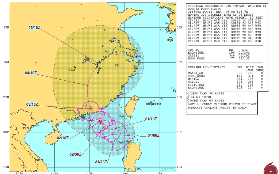
11:30 a.m. Friday, Sept. 1, Hong Kong time: Mawar remains a tropical depression as of late Friday morning. The latest Joint Typhoon Warning Center forecast takes Mawar 110 miles northeast of Hong Kong at 7 p.m. Sunday as a severe tropical storm.
6:45 a.m. Friday, Sept. 1, Hong Kong time: This simply isn’t Hong Kong’s summer when it comes to tropical cyclones.
As September dawns, a new tropical depression has formed just west of Luzon in the Philippines — and according to the Joint Typhoon Warning Center, it could affect Hong Kong sometime this weekend. It’s the 18th numbered storm of the northwest Pacific’s tropical cyclone season.
At 2 a.m., Mawar was 340 miles northwest of Manila, crawling northwest at 7 mph. If it remains on its current JTWC track, Mawar is forecast to pass 88 miles northeast of Hong Kong at 9 p.m. Sunday as a Category 1-equivalent typhoon or at least a severe tropical storm. Mawar is forecast to peak at 75-mph sustained winds and 92-mph gusts at 2 a.m. Sunday.
This would be the third tropical cyclone to affect Hong Kong since the third full week of August, on the heels of Hato and Pakhar. Hato’s fury caused the Hong Kong Observatory to raise Hurricane Signal 10 for the city for the first time since 2012.
