()
5 p.m. Monday, June 18, Japan time: It wasn't a classic typhoon in the destructive wind sense. But oh, did Tropical Storm Gaemi bring some rain with it. Japan Meterological Agency refers to Gaemi as a "once in 50 years" type of storm. Lots of rain. Tons of rain. Heavy rain. Okinawa's reservoir levels islandwide had been 45.2 percent, almost to the point where many thought the island would see water rationing for the first time since 1994. Now? We're up to almost 70 percent of capacity islandwide. 75 percent is considered the "safe zone" for Okinawa. We're almost there. And the forecast calls for rain the rest of the week. So, just how bad was Gaemi? Before even approaching Okinawa, the eighth numbered storm of the northwest Pacific's tropical cyclone season caused almost 14,000 homes to lose power on Miyako island. Izena island, just off Okinawa's northwest coast, recorded 15.75 inches of rain in one day, the most in the island's recorded history. Ie island, west of Nago, saw maximum wind speed of 138 mph, causing three injuries. Two people were hurt when a parked car got pushed by a gust of wind and smashed them between it and another vehicle, the other by shattered glass windows at Ie Airport. One man was injured in Itoman, on Okinawa main island, when construction material became airborne and smashed into him. Seven flooded homes were reported on Izena and four on Ie. Road blockages were reported in Nago and Kunigami due to broken trees and a small landslide. Nine flights serving Naha Airport and 79 ferries serving the island were canceled.5:45 p.m. Saturday, June 16, Japan time: You'd probably not believe it, after the Saturday morning Okinawa experienced, but the sun and blue sky are still up there. Yes, Tropical Storm Gaemi has finished its heavy rain flurry of this morning, has crossed over the northern tip of Okinawa and is making its way east of the Amami islands in the general direction of Honshu as a soon-to-be non-tropical low. Joint Typhoon Warning Center has issued its final warning on Gaemi. At 3 p.m., Gaemi was 74 miles east-northeast of Kadena, headed almost due east at 20 mph, holding steady at 40-mph sustained winds and 52-mph gusts. A few heavy rain and landslide warnings remain in effect for northern parts of Okinawa, and high-wave and gale advisories for the entire island. And wow, you talk about rainfall, especially for parts north on Okinawa: -- Oku village in Kunigami, about 5 miles southeast of Cape Hedo, received 12.6 inches in 24 hours, which exceeds most the rainfall ever recorded in June for Oku. -- Aguni island received 12.2 inches in 24 hours, the most ever recorded for the tiny island west of Okinawa main island. -- Izena island took 14.4 inches in 24 hours, also the most in the history of that island, almost due west of Cape Hedo. Naha and Kadena Air Base each received about 3 inches. Strongest winds recorded at Kadena came Saturday morning, 29-mph sustained winds and 46-mph gusts. Surprisingly, few flights were affected out of Naha International Airport. Only a handful of Vanilla Air flights were delayed. For the most part, the major airlines, Japan Air and All-Nippon, ran their full schedules in and out of the island with a few delays due to late arrival of some flights. But that's pretty much every day.Reservoir levels continue to increase. Dam capacity island-wide is now up to 66.3 percent, 21.2 percent higher than before all this rain began on Wednesday. And more is on the way as the annual rainy season continues, albeit a bit later than usual this year. Local forecasts call for rain daily deep into next week. PST will keep watch on the weather in the Yokosuka area the next couple of days, the next place Gaemi's remnants might affect. Forecast calls for rain on Monday, accompanied by east-northeasterly winds between 13 and 18 mph gusting to 29 mph, increasing by evening to 29- to 35-mph sustained, gusting to 46 mph.Noon Saturday, June 16, Japan time: While Tropical Storm Gaemi’s center is passing Okinawa about 40 miles northwest, its most beastly quadrants are passing right over the island, dumping tremendous amounts of rain, mostly on the northern parts of the island where the dams are, but enough on the heavily populated south end, where flooding and even landslides are a concern.
Japan Meteorological Agency has issued a Level 2 tornado advisory and a high-wave warning for the island. Flood warnings are in effect for Okinawa City, near Kadena Air Base, and Uruma City, near Camp Courtney. Give this link a gander to see if watches, advisories and warnings are in effect for your area.
At 9 a.m., Gaemi was 52 miles west-northwest of Kadena, headed east-northeast at 22 mph, holding steady at 40-mph sustained winds and 52-mph gusts. But again, it’s not the wind, but the copious amounts of rain that are of chief concern.
If there’s a silver lining to this, island reservoir levels continue to increase, up to 63.5 percent as of 10:50 a.m., up nearly 10 percent just this morning and 18 percent since the two tropical systems began passing through Okinawa on Wednesday.
6 a.m. Saturday, June 16, Japan time: Gaemi has been upgraded to a tropical storm by the Joint Typhoon Warning Center, and is continuing to pour copious amounts of rain on Okinawa, indeed all of Japan’s southwestern islands. That’s expected to continue through Saturday into early Sunday morning, according to local weather reports.
At 3 a.m., Gaemi was 170 miles west-southwest of Kadena Air Base, rumbling east-northeast at 19 mph, packing 40-mph sustained winds and 52-mph gusts at center. If it remains on its present path, Gaemi is forecast to hold steady at those wind values as it passes 50 miles northwest of Kadena at high noon.
As much as 6½ inches of rain is forecast to fall the rest of the day on the northern parts of the island, where it’s needed most – that’s where most of the reservoirs are. They’re up to 55.7 percent capacity as of 5:40 a.m., an increase of more than 10 percent over three days.
As for where Gaemi might go when it exits Okinawa, the Joint Typhoon Warning Center indicates that Gaemi will convert to a non-tropical low-pressure system as it heads northeast. But where?
Sasebo Naval Base and Marine Corps Air Station Iwakuni appear to be well out of whatever danger Gaemi poses; JTWC’s projected path takes it 295 miles southeast of Sasebo at 7 a.m. Sunday and 298 miles southeast of Iwakuni 8 hours later.
Model guidance shows Gaemi headed toward the Tokyo area after that, both the GEFS and GEPS ensembles in tight agreement. Heavy rain, much like what Okinawa is getting now, is forecast for Yokosuka come Monday.
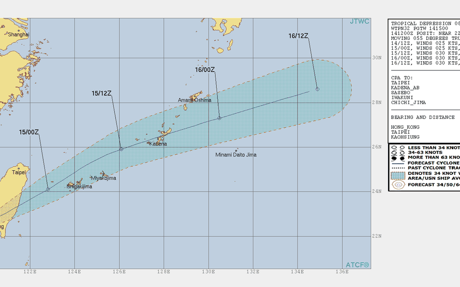
11:30 p.m. Friday, June 14, Japan time: Gaemi is moving, and rather rapidly, northeast toward a Saturday afternoon rendezvous with Okinawa. It could remain a tropical depression, it could intensify into a tropical storm by the time it passes the island, with wind gusts as high as 50 mph as it roars by. At 11:30 p.m., Gaemi was 292 miles west-southwest of Kadena Air Base -- having moved some 140 miles in the last five hours -- and still churning quickly northeast at 23 mph, holding steady at 35-mph sustained winds and 46-mph gusts. If it remains on its present course, Gaemi should pass 20 miles northwest of Kadena at about 4 p.m. Saturday. Heavy rain and gusty winds remain in the cards for Okinawa on Saturday. U.S. bases on island remain in seasonal Tropical Cyclone Condition of Readiness 4, and 18th Wing Weather Flight officials indicated no accelerated TCCORs, at least for the moment.7 p.m. Friday, June 14, Japan time: Tropical Depression Gaemi has exited Taiwan and is picking up forward speed toward Okinawa as it makes its way across the East China Sea. According to Kadena Air Base's 18th Wing Weather Flight, no upgraded Tropical Cyclone Conditions of Readiness are expected at the moment. At 6:45 p.m., Gaemi was 431 miles west-southwest of Kadena Air Base, rumbling east-northeast at 14 mph and holding steady at 35-mph sustained winds and 46-mph gusts. While Okinawa won't see typhoon-force winds, we can expect Gaemi to be upgraded to a tropical storm by morning or early afternoon Saturday, passing 12 miles south of Kadena by 5 p.m. Saturday, packing 40-mph sustained winds and 52-mph gusts at center. And rain. Oh, the rain. Lots of rain, lasting all the way into Sunday morning and beyond. Local Japanese and U.S. military forecasts call for rain lasting all the way through next Saturday. Not typhoon-related, but rain nonetheless. Reservoir capacity is up again, to 54.1 percent islandwide -- a gain of nearly 10 percent in two days. For the moment, Okinawa can expect 20-mph sustained southerly winds and 28-mph gusts Friday evening, increasing to 34-mph sustained winds and 46-mph gusts Saturday morning, diminishing Saturday afternoon. One thing that might happen due to high forecast winds at Naha International Airport is, flights may be canceled, inbound and outbound. Not good, considering school let out Thursday and a great many teachers and students are headed off to summer vacations in far-flung locales. To check flight status before you head to the airport, give the following flight-status links a look: All-Nippon Airways domestic and international, Japan Air Lines domestic and international, Jetstar domestic, Asiana international, Hong Kong Airlines and China Airlines.Noon Friday, June 15, Japan time: Tropical Depression Gaemi continues its slow grind across the rugged terrain of southern Taiwan. Thus, the Joint Typhoon Warning Center's latest forecast indicates that arrival over or close to Okinawa could be even later than initially projected a day ago. At noon, Gaemi was 513 miles southwest of Kadena Air Base, trudging northeast at 6 mph and holding steady at 35-mph sustained winds and 46-mph gusts. If it remains on its current track, it's due to pass 22 miles south of Kadena at 5 p.m. Saturday, 15 hours later that first forecast on Thursday. And talk about a piece of good news -- so much rain has fallen that the overall reseervoir capacity has jumped to 50.1 percent -- that's 5 percent higher than it was two days ago. With still more rain forecast to fall over the next week. Model guidance continues to be in tight agreement on a track taking Gaemi past Okinawa and a bit closer to Japan's main islands than Tropical Storm 07W was. Japan Meterological Agency has named 08W Gaemi, which is a Korean word for ant. Quite apropos, since this storm is relatively small.Midnight Thursday, June 14, Japan time: This could be the perfect recipe for Okinawa, which has suffered through quite a dry rainy season. That could change, thanks to the two tropical systems which have dumped copious amounts of rain on the island the last two days, with a lot more expected.
Tropical Depression 08W slowed some as it approached Taiwan overnight Thursday. At 6 a.m. Friday, 08W was 532 miles southwest of Kadena Air Base, crawling slowly northeast at 5 mph, holding steady at 35-mph sustained winds and 46-mph gusts.
If it remains on its present course, 08W is now expected to pass 15 miles south of Kadena Air Base at 11 a.m. Saturday, nine hours later than previously forecast. The wind values should remain the same, but 08W should be packing vast amounts of rain, showers and possible thunderstorms.
That’s ideal for Okinawa. Before the arrival of Tropical Storm 07W on Thursday, the average reservoir level for Okinawa’s 11 dams was 37.2 percent. Okinawa’s annual rainy season began in the middle of last month, but had been relatively dry at least up until now.
Rain has fallen steadily since late Wednesday evening and is forecast to continue all weekend, indeed through all of next week.
Friday’s local forecast, courtesy of Kadena’s 18th Wing Weather Flight, calls for winds shifting from the northeast to the south, between 10 and 20 mph sustained and gusts up to 28 mph. Expect that to increase on Saturday, southerly winds between 20 and 34 mph with gusts up to 46 mph. And rain. Lots of rain.
Midnight Thursday, June 14, Japan time: Looks for the moment like Tropical Depression 08W is doing its best to channel its inner Tropical Storm 07W a few hundred miles in front of it.
The two systems developed southwest of Taiwan and each moved generally eastward in Okinawa’s direction. 07W missed Kadena Air Base by about 60 miles northwest earlier Thursday; 08W is forecast by the Joint Typhoon Warning Center to make a near-direct hit, just three miles north of Kadena, at 2 a.m. Saturday. It should still be quite weak, packing but 35-mph sustained winds and 46-mph gusts.
And just like 07W, it appears as if 08W will then pick up forward speed, rapidly head east away from Okinawa and well south of Japan’s main islands. Then again, we are talking weather, unpredictable, and it’s quite early in the life of a young storm. PST will keep an eye on it.
6:30 p.m. Thursday, June 14, Japan time: Another ... just like the other. A second tropical depression in as many days has formed just southwest of Taiwan, and it appears as if it will be just as small and weak as its predecessor, 07W, which passed by Okinawa Thursday evening. At 6 p.m., 08W was 611 miles west-southwest of Kadena Air Base, headed northeast at 9 mph with 29-mph sustained winds and 40-mph gusts, according to the Joint Typhoon Warning Center. U.S. bases on Okinawa remain in Tropical Cyclone Condition of Readiness Storm Watch. If it remains on its current path, 08W will cross southern Taiwan and pass 15 miles south of Kadena at 2 a.m. Saturday, packing 35-mph sustained winds and 46-mph gusts as it moves through south-central Okinawa. The initial forecast track indicates 08W should remain well away from Japan's main islands. But it's early yet in the life of yet another young storm. PST has an eye on it. 08W will also have a minimal effect on the Batanes island group in the northern Philippines. It's due to enter the Philippines area of responsibility Thursday night or Friday morning and be called Ester by the national weather authority PAGASA. Tropical Storm Warning Signal 1 has been raised for the Batanes islands.2:30 p.m. Thursday, June 14, Japan time: A second disturbance has formed a few hundred miles behind Tropical Storm 07W, currently affecting Okinawa. Joint Typhoon Warning Center has issued a tropical cyclone formation alert on the system, 95W Invest, which could bring even more rain and gusty winds to the island over the weekend.
At 1:30 p.m., 95W Invest was about 245 miles east-southeast of Okinawa, moving east-northeast at 9 mph. Initial model guidance does indicate passage close to Okinawa in the next couple of days.
