()
Noon Monday, June 11, Japan time: Tropical Storm Maliksi’s winds continue gradually diminishing, down to 52-mph sustained winds and 63-mph gusts as it rolls well offshore southeast of Tokyo. It’s forecast to pass 226 miles southeast of Yokosuka Naval Base at 4 p.m. Look for 23- to 29-mph sustained winds and 40-mph gusts Monday afternoon at Yokosuka, diminishing to 18- to 23-mph sustained and 35-mph gusts Tuesday morning.
A small-craft advisory remains in effect until 11 p.m. Monday. Unless Maliksi’s track changes drastically, this is PST’s final report on the sixth numbered storm of the season
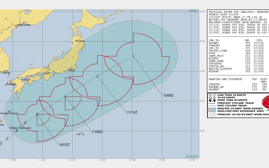
Midnight Sunday, June 10, Japan time: The bad news: Maliksi remains a significant tropical storm. The good news: It’s begun moving more quickly east-northeast on a track taking it slightly further southeast of Tokyo than previously forecast, according to the Joint Typhoon Warning Center .
At 3 a.m., Maliksi was 455 miles southeast of Marine Corps Air Station Iwakuni, hurtling east-northeast at 30 mph and holding steady at 58-mph sustained winds and 75-mph gusts at center. If it remains on its current path, Maliksi is forecast to pass 270 miles southeast of Yokosuka Naval Base at 4 p.m.
Still, heavy rain and gusty winds will rule the day at Fleet Activities Yokosuka. The official forecast calls for day-long rain and winds between 18 and 23 mph with 35-mph gusts in the morning, increasing to 23 to 29 mph with 40-mph gusts late in the afternoon, decreasing to 18 to 23 with 35-mph gusts by Tuesday morning, diminishing thereafter.
Midnight Sunday, June 10, Japan time: Tropical Storm Maliksi has bid farewell to Okinawa, has weakened slightly and is picking up forward speed as it hurtles along a path taking it southeast of Tokyo, according to the Joint Typhoon Warning Center.
At 9 p.m., Maliksi was 463 miles south-southeast of Marine Corps Air Station Iwakuni, Japan, streaking northeast at 26 mph, and has diminished to 58-mph sustained winds and 75-mph gusts at center. If it stays on its current path, Maliksi should pass 215 miles southeast of Yokosuka Naval Base at 4 p.m. Monday, still packing 52-mph sustained winds and 63-mph gusts, but at storm’s center.
Fleet Activities Yokosuka’s official weather outlook calls for winds between 15 and 20 mph with 30-mph gusts in the morning, increasing to 20 to 25 mph with 35-mph gusts in the evening, dropping off to 15 to 20 mph and 30-mph gusts Tuesday morning and diminishing from there. A small-craft warning remains in effect until 11 p.m. Monday.
6 p.m. Sunday, June 10, Japan time: There's a strong probability that Tropical Storm Maliksi will fall just short of becoming the second typhoon of the northwest Pacific’s tropical cyclone season, according to the Joint Typhoon Warning Center. The first one was Jelawat in late March, which became a Category 5-equivalent super typhoon, but threatened no land.
At 3 p.m., Maliksi was 266 miles east of Kadena Air Base, Okinawa, moving rapidly northeast at 21 mph and holding steady at 69-mph sustained winds and 86-mph gusts at center, just under Category 1-equivalent status. JTWC projects Maliksi to weaken gradually as it charges northeast in the general direction of Tokyo.
If it remains on its current track, Maliksi is forecast to pass 191 miles southeast of Yokosuka Naval Base at 4 p.m. Monday, still packing 63-mph sustained winds and 81-mph gusts at center. Fleet Activities Yokosuka’s official forecast calls for light rain starting Sunday evening continuing into Tuesday, with winds increasing to 15- to 20-mph sustained and 30-mph gusts through Monday evening.
Noon Sunday, June 10, Japan time: Tropical Storm Maliksi’s time of closest point of approach to Okinawa has come and gone. It remains a gusty, showery afternoon on the island, and if anything, Maliksi is forecast to intensify as it picks up forward speed and hurtles past Tokyo on Monday afternoon, according to the Joint Typhoon Warning Center.
At 9 a.m., Maliksi was 208 miles east-southeast of Kadena Air Base, tracking northeast at 23 mph and was just below Category 1 strength, 69-mph sustained winds and 86-mph gusts at center. Maliksi is due to peak at 75-mph sustained winds and 92-mph gusts at center Sunday afternoon or evening, before gradually weakening as it rumbles northeast.
If it remains on its present course, Maliksi is due to pass 196 miles southeast of Yokosuka Naval Base, still packing 58-mph sustained winds and 75-mph gusts as it roars past. A small-craft warning is in effect for Fleet Activities Yokosuka. Forecast calls for northerly winds of 15 to 20 mph with 30-mph gusts as Maliksi passes by.
6 a.m. Sunday, June 10, Japan time: Tropical Storm Maliksi is making its way 200 miles southeast of Kadena Air Base, which along with the rest of the southern part of Okinawa is getting some serious northerly gusts, up to 35 mph, and heavy rain bands as Maliksi prepares for its long but speedy run past Tokyo early this week.
At 6 a.m., Maliksi was 200 miles southeast of Kadena, headed northeast at 15 mph and its central fury had increased slightly, 58-mph sustained winds and 75-mph gusts. Maliksi is forecast to peak at 63-mph sustained winds and 81-mph gusts at center at mid-afternoon Sunday. U.S. bases on Okinawa remain in seasonal Tropical Cyclone Condition of Readiness 4.
If Maliksi remains on its current track, it’s due to pass 207 miles southeast of Yokosuka Naval Base at 5 p.m. Monday as a middling tropical storm, 52-mph sustained winds and 63-mph gusts at center. Fleet Activities Yokosuka’s forecast calls for rain Sunday evening and Monday and isolated thunderstorms to follow, with northeasterly wind up to 30 mph overnight Sunday through Monday afternoon.
Midnight Saturday, June 9, Japan time: Minor adjustments to Tropical Storm Maliksi’s wind speeds and closest-point-of-approach timing. If it remains on its current Joint Typhoon Warning Center forecast track, it’s due to peak at 63-mph sustained winds at 9 p.m. Sunday, rumble 186 miles southeast of Kadena Air Base at 6 a.m. Sunday, then gradually weaken, pick up forward speed and roar 220 miles southeast of Yokosuka Naval Base at 5 p.m. Monday. U.S. bases on Okinawa remain in Tropical Cyclone Condition of Readiness 4.
6 p.m. Saturday, June 9, Japan time: The bad news: Tropical Storm Maliksi’s forecast track keeps edging closer to Okinawa. The good news: It’s still forecast to pass well to the island’s southeast. And forecast peak winds according to the Joint Typhoon Warning Center keep diminishing as well, now just over 80-mph gusts at center overnight Saturday into Sunday.
At 3 p.m., Maliksi was 285 miles south of Kadena Air Base, moving north-northeast at 13 mph and had begun intensifying, 52-mph sustained winds and 63-mph gusts at center. If it remains on its present course, Maliksi is due to pass 190 miles southeast of Kadena at 4 a.m. Sunday. U.S. bases on Okinawa remain in seasonal Tropical Cyclone Condition of Readiness 4.
The forecast track is also edging closer to Tokyo, but Maliksi will still remain well off the southeastern coast – 235 miles southeast of Yokosuka Naval Base at 2 p.m. Monday. Heavy rain and winds between 20-30 mph are forecast starting Monday afternoon and continuing throughout Tuesday. Watch for flash flooding in low-lying areas Monday evening into mid-day Tuesday.
2 p.m. Saturday, June 9, Japan time: Tropical Storm Maliksi has begun edging northeast and remains on a path taking it well southeast of Okinawa. U.S. bases on the island remain in seasonal Tropical Cyclone Condition of Readiness 4. Maliksi is due to pass 220 miles southeast of Kadena Air Base at mid-day Sunday, and is forecast by Joint Typhoon Warning Center to peak at 69-mph sustained winds and 86-mph gusts at center.
6 a.m. Saturday, June 9, Japan time: In addition to passing just over 200 miles southeast of Okinawa over the weekend, Tropical Storm Maliksi’s peak forecast intensity has been dialed back a tad, according to the Joint Typhoon Warning Center. And Maliksi should also miss Tokyo well to the southeast as well.
At 3 a.m., Maliksi was nearly 400 miles south of Kadena Air Base, Okinawa, headed north at 12 mph, holding steady at 46-mph sustained winds and 58-mph gusts. Maliksi is forecast to start tracking northeast by Saturday afternoon, passing 206 miles southeast of Okinawa about 3 a.m. Sunday. U.S. bases on Okinawa remain in seasonal Tropical Cyclone Condition of Readiness 4.
Peak intensity should put Maliksi right at Category 1-equivalent typhoon strength, 75-mph sustained winds and 92-mph gusts at Maliksi’s center, between 3 a.m. and 3 p.m. Sunday, gradually decreasing as it picks up steam and rumbles northeast. Closest point of approach for Yokosuka Naval Base is nearly 250 miles southeast at 2 p.m. Monday.
Okinawa can expect easterly gusts up to 35 mph with a 30- to 40-percent chance of showers and possible thunderstorms on Saturday, with winds shifting around to the northwest on Sunday, according to local military and Japanese weather forecasts. Forecast models remain in fairly tight agreement.
Midnight Friday, June 8, Japan time: Things pretty much remain the same regarding Tropical Storm Maliksi, according to the latest Joint Typhoon Warning Center forecast track. At 9 p.m., Maliksi was 466 miles south of Kadena Air Base, Okinawa, traveling due north at 9 mph and holding steady at 46-mph sustained winds and 58-mph gusts.
If Maliksi remains on its current forecast track, it’s due to curve northeast and pass about 210 miles southeast of Kadena at 2 a.m. Sunday. U.S. bases on island remain in seasonal Tropical Cyclone Condition of Readiness 4. There might be a chance of upgrade to TCCOR 3 just as a precaution, in case the track changes or Maliksi intensifies more than currently forecast.
That’s the 18th Wing commanding officer’s call. As always, pay as little attention to the rumor mill as possible and wait for word from official channels.
JTWC projects Maliksi to intensify into a typhoon at mid-evening Saturday, then peak at 86-mph sustained winds and 104-mph gusts at center around mid-morning Sunday. Expect easterly winds between 20 and 30 mph starting mid-day Saturday, shifting around to the northwest on Sunday as Maliksi rumbles to Okinawa’s southeast.
Though model guidance remains in fairly tight agreement on a northeast curve, Maliksi is still a young storm, and its current forecast track was adjusted about 40 miles further north and west than the initial track. Point being, things can change.
6 p.m. Friday, June 8, Japan time: Though Tropical Storm Maliksi should remain quite a ways away from Okinawa, the forecast track has edged a bit closer than previously reported.
U.S. bases on island remain in Tropical Cyclone Condition of Readiness 4 and peak forecast winds this weekend remain at 30-mph top speed, according to Kadena Air Base’s long-range weather forecast.
At 3 p.m., Maliksi was 506 miles south of Kadena, tracking almost due north at 13 mph and holding steady at 46-mph sustained winds and 58-mph gusts. If it remains on its present course, Maliksi is due to pass 213 miles southeast of Kadena at 2 a.m. Sunday, packing 86-mph sustained winds and 104-mph gusts, but those are at storm’s center. And Maliksi’s forecast fiercest fury is in its southern quadrants.
Forecast models continue to depict Maliksi passing southeast of Okinawa. All this could change in the early life of a young storm. PST will keep an eye on it.
1 p.m. Friday, June 8, Japan time: Maliksi developed quickly into the sixth numbered storm of the northwest Pacific tropical cyclone season and may be the first to threaten Okinawa, according to the Joint Typhoon Warning Center’s initial forecast track.
At 9 a.m., Maliksi was 484 miles east-northeast of Manila, headed northeast at 15 mph, packing 46-mph sustained winds and 58-mph gusts. If it remains on its current track, Maliksi is due to pass 260 miles southeast of Kadena Air Base at 1 a.m. Sunday, packing 75-mph sustained winds and 92-mph gusts at center.
U.S. bases on Okinawa remain in seasonal Tropical Cyclone Condition of Readiness 4. The long-range forecast for Kadena calls for scattered showers and winds up to 30 mph over the weekend.
All that could change; it’s the initial forecast track. Keep an eye on PST, which will keep an eye on Maliksi.
