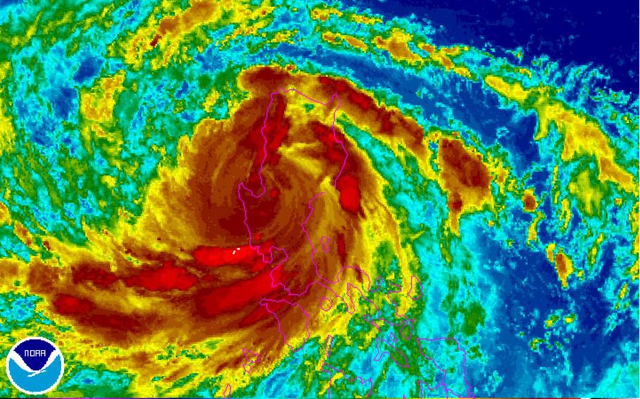
Typhoon Sarika slammed ashore early Sunday morning near Aurora on the east coast with Category 4-equivalent winds and heavy rain bombarding central Luzon as it continues west. (www.NOAA.gov)
7:30 p.m. Sunday, Oct. 16, Philippines time: All public storm warning signals have been lowered in the Philippines, as Typhoon Sarika -- known as Karen in the Philippines -- continues out over the South China Sea and heads toward Vietnam. As if Vietnam had enough problems, with 15 already dead, more than 100,000 homes inundated and 25,000 acres of crops washed out. Quang Binh province is most affected by rain and flooding, according to the Wall Street Journal. PST continues to eye Sarika, just in case,Noon Sunday, Oct. 16, Philippines time: At least two were killed, several more injured, hundreds of thousands were without power and nearly 200 flights were canceled with thousands of passengers stranded in air and seaports following the passage of Typhoon Sarika over the Philippines Sunday morning.
At 8 a.m., Sarika – called Karen in the Philippines – was 138 miles north-northwest of Manila, tracking west-northwest at 22 mph, packing 92-mph sustained winds and 115-mph gusts at center. Sarika made landfall over Aurora early Sunday morning packing Category 4-equivalent winds and gusts across central Luzon.
Public Storm Warning Signal 3 has been lowered. PSWS Signal 2 remains up for parts of west-central Luzon and PSWS Signal 1 for Manila and the former Clark Air Base and Subic Bay Naval Station.
Sarika moved back over open water at mid-morning and is now over the South China Sea, expected to re-intensify as it approaches Hainan island later this week. Secondary landfall is forecast for northern Vietnam at mid-morning Wednesday.
7 a.m. Sunday, Oct. 16, Philippines time: It’s happening. Typhoon Sarika slammed ashore early Sunday morning near Aurora on the east coast with Category 4-equivalent winds and heavy rain bombarding central Luzon as it continues west.
At 2 a.m., Sarika – called Karen in the Philippines – was 100 miles north-northeast of Manila, rumbling northwest at 15 mph packing 132-mph sustained winds and 161-mph gusts at center. Public Storm Warning Signal 3 remained raised for areas directly affected by Sarika, with Signal 2 up for Metro Manila and the former Clark Air Base and Subic Bay Naval Station.
Sarika passed 62 miles north of Clark and 95 miles north of Subic and Manila at about 7 a.m. Sunday and is due to continue west-northwest, making its way back over water in the South China Sea packing 98-mph winds and 121-mph gusts at center as it exits land by mid-afternoon.
11 a.m. Saturday, Oct. 15, Philippines time: Sarika has intensified into a Category 2-equivalent typhoon, its forecast track has wobbled closer to Manila and the former Clark Air Base and Subic Bay Naval Station and its forecast intensity has increased as well, according to the Joint Typhoon Warning Center.
At 8 a.m., Sarika – called Karen in the Philippines – was 228 miles east of Manila, tracking due west at 9 mph, packing 92-mph sustained winds and 115-mph gusts at center. If it remains on its current path, Sarika is due to crash ashore near Aurora on Luzon’s southeast coast, packing 110-mph sustained winds and 132-mph gusts at center.
Sarika is due to pass 23 miles north of Clark and 55 miles north of Subic Bay and Manila, between 1 and 5 a.m. Sunday. Public Storm Warning Signal 1 remains up for the aforementioned, while PSWS Signal 3 remains raised for Aurora, Catanduanes, Camarines Norte and northern Quezon in Sarika’s direct path.
7:30 a.m. Saturday, Oct. 15, Philippines time: Sarika has been upgraded to a Category 1-equivalent typhoon by the Joint Typhoon Warning Center. It remains on course to plow through the Philippines’ northernmost island of Luzon over the weekend.
At 2 a.m., Sarika, called Karen in the Philippines, was 282 miles east of Manila, tracking west-northwest at 8 mph packing 75-mph sustained winds and 92-mph gusts at center. If it remains on its current path, Sarika is due to peak at 104-mph sustained winds and 127-mph gusts as it rumbles ashore early Sunday morning.
Publci Storm Warning Signal 1 remains in effect for Metro Manila and the former Clark Air Base and Subic Bay Naval Station, with PSWS Signal 3 raised for Catanduanes and PSWS Signal 2 for other areas in Sarika’s direct path. Sarika is due to pass 50 miles north of Clark and 82 miles north of Manila and Subic between 1 and 6 a.m. Sunday, packing sustained 92-mph winds and 115-mph gusts at center as it blows through.
Sarika is then forecast to head back over water in the South China Sea and re-intensfy before grazing Hainan island and making secondary landfall southeast of Hanoi, Vietnam, early Thursday morning.
Noon Friday, Oct. 14, Philippines time: News gets a tad worse for the former U.S. Clark Air Base and Subic Bay Naval Station as the latest forecast track takes Tropical Storm Sarika closer to each, as well as to Manila.
At 8 a.m., Sarika was 425 miles east of Manila, tracking due west at 10 mph, packing sustained 52-mph winds and 63-mph gusts at center. If Sarika, called Karen in the Philippines, remains on its current course, it’s now due to pass just 54 miles north of Subic and Manila and just 21 miles north of Clark between 9 a.m. and 1 p.m. Sunday.
Sarika is forecast to make landfall over south-central Luzon at 8 a.m. Sunday, packing 104-mph sustained winds and 127-mph gusts at center as it roars ashore. It’s also due to skim the northern edges of the Visayas island group.
The Philippines’ weather authority PAGASA has raised Public Storm Warning Signal 1 for Metro Manila, Clark and Subic and other parts of south-central Luzon. Expect that to be upgraded. Signal 3 is up for Catanduanes in southeastern Luzon facing Sarika.
6 a.m. Friday, Oct. 14, Philippines time: Could be double trouble for the Philippines in the coming week-plus.
In addition to Tropical Storm Sarika (Helen) bearing down on the islands, a tropical cyclone formation alert was issued by the Joint Typhoon Warning Center on a disturbance (94W Invest), forming south of Guam but projected to track northwest between the Philippines and Taiwan in a week or so.
As for Sarika, it was 490 miles east of Manila at 2 a.m., tracking west-northwest at 6 mph. If it continues on its present course, Sarika is due to make landfall over central Luzon early Sunday morning, passing 58 miles north of the former Clark Air Base, 92 miles north of the former Subic Bay Naval Station and 90 miles north of Manila between 9 a.m. and 1 p.m. Sunday. It’s forecast to be packing 98-mph sustained winds and 121-mph gusts as it crashes ashore.
11 p.m. Thursday, Oct. 13, Philippines time: Sarika has been upgraded to a tropical storm by the Joint Typhoon Warning Center and it continues to take aim at central Luzon. It remains on course to pass 73 miles north of the former Clark Air Base, 103 miles north of Manila and 107 miles north of the former Subic Bay Naval Station between 8 a.m. and noon Sunday, packing 92-mph sustained winds and 115-mph gusts as it roars ashore. Sarika, called Karen in the Philippines, is first due to skim north of the Visayas island group. Public Storm Warning Signal 1 remains raised for Catanduanes, in east Luzon.
5 p.m. Thursday, Oct. 13, Philippines time: The areas where the just-completed exercise PHILBEX 2016 took place may soon come under assault from Ma Nature, in the form of Tropical Depression 24W, in the coming days, according to the Joint Typhoon Warning Center. 24W is forecast to become a typhoon and batter the central portions of the Philippines’ northernmost main island, Luzon.
At 2 p.m., 24W was 570 miles east-southeast of Manila, tracking northwest at 7 mph. If it remains on its current course, 24W is forecast to pass 58 miles north of the former Clark Air Base, 92 miles north of the former Subic Bay Naval Station and 87 miles north of Manila between 8 a.m. and 1 p.m. Sunday, packing 81-mph sustained winds and 98-mph gusts at center.
PAGASA, the Philippines’ national weather authority, has issued Public Storm Warning Signal 1 for Catanduanes, an island province in east Luzon, and warns that residents of central Luzon, Samar and the Visayas to the southeast begin preparing for 24W’s imminent arrival. PAGASA is calling the storm Karen.
5:45 a.m. Thursday, Oct. 13, Philippines time: Looks like things could get really gusty and showery for central Luzon over the weekend.
Newly formed Tropical Depression 24W’s forecast track has been adjusted slightly south, putting the Philippines’ northernmost main island directly in the crosshairs for a visit Sunday afternoon with gusts as high as 127 mph as 24W approaches the island.
At 2 a.m., 24W was 621 miles east of Manila, tracking west-northwest at 5 mph. If 24W remains on its current track, it’s forecast to pass just 38 miles north of the former Clark Air Base, 73 miles north of the former Subic Bay Naval Station and 67 miles north of Manila between noon and 5 p.m. Sunday, packing sustained 104-mph winds and 127-mph gusts at center.
No public storm warning signals have been raised for the Philippines. The country’s weather authority PAGASA has issued its first severe weather bulletin on 24W.
If it becomes a named storm, 24W would be called Sarika, Cambodian for singing bird.
11 p.m. Wednesday, Oct. 12, Philippines time: A new tropical depsression, the 24th numbered storm of the northwest Pacific’s tropical cyclone season, has formed some 600 miles east of Manila and is forecast to burrow across the Philippines’ northern island of Luzon in the coming days, according to the Joint Typhoon Warning Center.
24W is forecast to reach 86-mph sustained winds and 104-mph gusts as it approaches the ast coast of Luzon, coming ashore Sunday afternoon, diminishing briefly, then peaking at 92-mph sustained winds and 115-mph gusts on Monday as it crosses into the South China Sea.
If it remains on its initial JTWC forecast track, 24W should pass 105 miles north of the former Clark Air Base and 139 miles north of the former Subic Bay Naval Station as a Category 1-equivalent typhoon or severe tropical storm. PST has an eye on it.
11:30 a.m. Wednesday, Oct. 12, Philippines time: Joint Typhoon Warning Center has issued a tropical cyclone formation alert on a disturbance about 750 miles east-southeast of Manila at 6 a.m. Early forecast models depict movement north-northwest and an eventual track taking it between the Philippines’ northernmost island of Luzon and southern Taiwan – the precise path of previous storms this summer that devastated the areas. PST has an eye on it.
