()
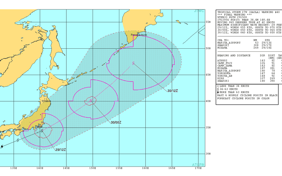
11:15 p.m. Sunday, Oct. 29, Japan time: The winds and rain are dying down. Saola, now considered an extra-tropical cyclone, is exiting the Tokyo-Kanto Plain area and peace is resuming its sway, as it was Friday before all the nastiness arrived.
At 9 p.m., Saola was 74 miles south-southeast of Yokosuka Naval Base and moving rapidly northeast at 48 mph, still packing 63-mph sustained winds and 81-mph gusts at center. The thunderstorm warning remains in effect for just awhile longer, until midnight, and the high wind-gale warning until 5 a.m.
Joint Typhoon Warning Center just issued its final warning on Saola … and so has PST.
5:30 p.m. Sunday, Oct. 29, Japan time: Saola enjoyed a brief life as a Category 1-equivalent typhoon. But alas, it’s now been downgraded to a tropical storm as it puts the Tokyo-Kanto Plain area squarely in its sights, according to the Joint Typhoon Warning Center. At 3 p.m., Saola was 243 miles east-southeast of Marine Corps Air Station Iwakuni and rapidly chugging east-northeast at 33 mph, now packing a “mere” 69-mph sustained winds and 86-mph gusts at center – still a strong tropical storm. Saola’s track has shifted east, back out over water. If it continues moving as forecast, Saola is due to pass 32 miles south-southeast of Yokosuka Naval Base at 9 p.m. Sunday. Fleet Activities Yokosuka remains in Tropical Cyclone Condition of Readiness Storm Watch, as does MCAS Iwakuni. Fleet Activities Sasebo is in TCCOR All Clear. A thunderstorm warning remains in effect for Yokosuka until midnight and a high-wind gale warning until 5 a.m. Monday. Yokosuka remains forecast to get 23- to 29-mph sustained winds and 40-mph gusts, increasing to 40- to 46-mph sustained winds and 63-mph gusts late in the evening, diminishing back to 23- to 29-mph sustained and 40-mph gusts overnight.
11 a.m. Sunday, Oct. 29, Japan time: Saola barely clings to Category 1-equivalent typhoon status. Its track has slowed slightly and shifted a bit further west, taking Saola over the Tokyo area, according to the Joint Typhoon Warning Center. At 9 a.m., Saola was 195 miles south-southeast of Marine Corps Air Station Iwakuni, headed northeast at 23 mph, with 75-mph sustained winds and 92-mph gusts. If Saola remains on its current track, it’s forecast to pass 9 miles southeast of Camp Zama and Naval Air Facility Atsugi and 23 miles northwest of Yokosuka Naval Base, packing 63-mph sustained winds and 81-mph gusts at center.
10 a.m. Sunday, Oct. 29, Japan time: Expect a rainy, gusty Sunday in the Kanto Plain, with wind gusts up to 63 mph late in the evening at Yokosuka Naval Base as Typhoon Saola comes roaring through, but not quite as nasty as last weekend was with Lan. Saola is forecast to pass just 20 miles south of Yokosuka at 8 p.m. Sunday. The base and its satellite stations remain in Tropical Cyclone Condition of Readiness Storm Watch. The worst of Saola appears to be in its two southern quadrants, further away from the base. So while it will still be nasty, it could be worse. It yet might, if Saola does track further inland. A high-wind gale warning is in effect for Yokosuka, according to NOAC Yokosuka’s weather forecast. Expect northeasterly winds between 23- and 29-mph sustained with 40-mph gusts through the day, increasing to 40- to 46-mph sustained and 63-mph gusts late evening, diminishing to 23- to 29-mph sustained and 40-mph gusts overnight. Saola is moving quite quickly, 25 mph as it moves northeast and should be through the Tokyo-Kanto Plain area rather rapidly. PST will keep an eye out in case things change.
12:30 a.m. Sunday, Oct. 29, Japan time: Typhoon Saola has bid farewell to Okinawa after making its relatively quick visit over the last day-plus. Now, it turns its attention to the Tokyo-Kanto Plain area, with a forecast track taking it just south of Yokosuka Naval Base before hurtling to its demise as the week begins.
At 9 p.m., Saola was 181 miles northeast of Kadena Air Base, trucking northeast at 20 mph and had intensified slightly, to 81-mph sustained winds and 98-mph gusts. If it remains on its current path, Saola is due to pass 41 miles south-southeast of Yokosuka at 9 p.m. Sunday. Much of its fury is forecast to remain confined to the southern quadrants of the storm.
U.S. bases on Okinawa have resumed seasonal Tropical Cyclone Condition of Readiness 4. Fleet Activities Yokosuka remains in TCCOR Storm Watch. Depending on what path Saola takes, TCCOR could be upgraded by mid-morning Sunday. Check out Yokosuka’s weather forecast.
7:30 p.m. Saturday, Oct. 28, Japan time: So, where to from here now that Typhoon Saola is preparing to bid Okinawa farewell?
Since Typhoon Lan seemed to enjoy the route so much, perhaps Saola is deciding to follow in Lan’s footsteps and pay a visit to the Tokyo-Kanto Plain area, specifically just south of Yokosuka Naval Base, though Saola doesn’t appear to pack as much of a punch as Lan did.
At 3 p.m., Saola was 55 miles northeast of Kadena Air Base and moving north-northeast at 18 mph, packing 75-mph sustained winds and 92-mph gusts. U.S. bases on Okinawa remain in Tropical Cyclone Condition of Readiness 1-R.
Saola is forecast long term to pick up forward speed, but also reach peak intensity of 86-mph sustained winds and 104-mph gusts at 3 p.m. Sunday just south of Kyoto as it roars toward the Tokyo area.
Closest point of approach to Yokosuka is forecast to be 27 miles southeast at 9 p.m. Sunday. The good news is, most of the destructive winds are forecast to be in the south quadrants away from the base. Fleet Activities Yokosuka remains in TCCOR Storm watch; that may be upgraded, depending on Saola’s track in the coming hours.
Weather forecasts at Yokosuka call for northeasterly winds of 23 to 29 mph sustained with 40-mph gusts in the early evening, increasing to 35- to 40-mph sustained with 52-mph gusts late evening, decreasing to 23 to 29 mph sustained and 40-mph gusts overnight into Monday.
7 p.m. Saturday, Oct. 28, Japan time: U.S. bases on Okinawa have entered Tropical Cyclone Condition of Readiness 1-R (recovery). Destructive winds of 58 mph or greater are no longer occurring. Survey crews are now out assessing damage. R esidents must remain indoors until the all clear is sounded.
12:30 p.m. Saturday, Oct. 28, Japan time: Here is the latest wind-forecast timeline for Okinawa, courtesy of Kadena Air Base’s 18th Wing Weather Flight. Yes, the winds are due to pick back up and max out at 2 p.m. U.S. bases remain in Tropical Cyclone Condition of Readiness 1-E.
Peak 75-mph sustained winds and 81-mph gusts: 2 p.m. Saturday. Winds subsiding below 58-mph sustained: 10 p.m. Saturday. Winds subsiding below 40-mph sustained: 9 a.m. Sunday.A reminder from 18th Security Forces at Kadena: STAY INDOORS. That includes periods of TCCOR 1-R, when survey crews are out inspecting damage and establishing safe zones, even through TCCOR Storm Watch. Stay inside until the all-clear is sounded or seasonal TCCOR 4 resumes.
12:30 p.m. Saturday, Oct. 28, Japan time: So, why did things get so quiet?
The weather might be beautiful now — but don’t be fooled. It’s just the eye of Typhoon Saola (and it is a typhoon, finally) passing over Okinawa. In a while, the winds will resume, in the opposite direction and probably more fierce, since the south side of any storm is much more nasty.
So, for the time being, residents are advised to stay indoors. At any moment, things could turn for the worst. Bases on Okinawa remain in Tropical Cyclone Condition of Readiness 1E for a reason.
At 9 a.m., Saola was 70 miles south of Kadena Air Base, moving north at 14 mph packing 75-mph sustained winds and 92-mph gusts. It’s passing over Okinawa right now; the south bands should be over the island very soon.
Saola should peak at 86-mph sustained winds and 104-mph gusts after it exits the Okinawa area and arcs toward Japan’s main islands. Saola is due to sideswipe the south coast of Kyushu, then head toward the Tokyo-Kanto Plain area, as did Lan a week ago.
7:30 a.m. Saturday, Oct. 28, Japan time: Here is the latest wind-forecast timeline for Okinawa, courtesy of Kadena Air Base’s 18th Wing Weather Flight. U.S. bases on Okinawa remain in Tropical Cyclone Condition of Readiness 1-E:
Peak winds of 75-mph sustained, 92-mph gusts: Noon Saturday. Winds subsiding below 58-mph sustained: 10 p.m. Saturday. Winds subsiding below 40-mph sustained: 9 a.m. Sunday.Okinawa can expect between 3 to 5 inches of rain.
6 a.m. Saturday, Oct. 28, Japan time: U.S. bases on Okinawa have entered Tropical Cyclone Condition of Readiness 1-E (emergency). Actual 58-mph sustained winds are occurring. All outdoor activity is prohibited. Stay indoors until the all clear is given or seasonal TCCOR 4 has resumed.
6 a.m. Saturday, Oct. 28, Japan time: Almost as if gently taping the brakes slightly, as if to get a better view of the island, Tropical Storm Saola has slowed as it approaches Okinawa. Though still forecast to pass right over the island, it’s likely that peak winds will occur later in the day.
At 3 a.m., Saola was still 174 miles south of Kadena Air Base, moving north at 9 mph, holding steady at 63-mph sustained winds and 81-mph gusts at center. If it continues moving as forecast, Saola is now due to pass 5 miles west of Kadena at 6 p.m. as a Category 1-equivalent typhoon, 75-mph sustained winds and 92-mph gusts.
Saola is next due to turn gradually northeast, rapidly picking forward speed and gradually losing strength as it skims the south coast of Shikoku and Honshu islands, almost reprising the path taken by Lan a week earlier. Saola is forecast to pass 62 miles south-southeast of Yokosuka Naval Base packing 63-mph sustained winds and 81-mph gusts at center.
Expect upgrade to Tropical Cyclone Condition of Readiness 1-E on Okinawa at any point. TCCOR Storm Watch remains in effect for Fleet Activities Sasebo and Yokosuka and Marine Corps Air Station Iwakuni.
2 a.m. Saturday, Oct. 28, Japan time: Here is the latest wind-forecast timeline for Okinawa, courtesy of Kadena Air Base’s 18th Wing Weather Flight. U.S. bases could enter Tropical Cyclone Condition of Readiness 1-C (caution) as early as 3 a.m. Saturday and TCCOR 1-E (emergency) three hours or so later.
Onset of 40-mph sustained winds: 3 a.m. Saturday (expect TCCOR 1-C) Onset of 58-mph sustained winds: 6 a.m. Saturday (expect TCCOR 1-E). Peak 75-mph sustained winds, 92-mph gusts: Noon Saturday. Winds subsiding below 58 mph: Midnight Saturday. Winds subsiding below 40 mph: Noon Sunday.Midnight Friday, Oct. 27, Japan time: Like a virtual fist curled up into a ball, Tropical Storm Saola is drawing a bead on Okinawa, making tracks toward a direct hit on Kadena Air Base.
And looks as though the Kanto Plain might get sideswiped as well, according to the Joint Typhoon Warning Center.
At 9 p.m., Saola was 195 miles south of Kadena Air Base, headed north-northwest at 17 mph and had intensified to 63-mph sustained winds and 81-mph gusts at center.
JTWC projects Saola to make a direct pass over Kadena at high noon Saturday as a Category 1-equivalent typhoon, 75-mph sustained winds and 86-mph gusts.
It should impact Okinawa for the better part of Saturday into early Sunday, after which expect Saola to skedaddle northeast and graze the Kanto Plain just to its south.
Saola is due to pass 59 miles south of Yokosuka Naval Base at midnight Sunday, still packing 63-mph sustained winds and 81-mph gusts at center.
Fleet Activities Yokosuka and Sasebo and Marine Corps Air Station Iwakuni remain in Tropical Cyclone Condition of Readiness Storm Watch.
U.S. bases on Okinawa remain in TCCOR 1. Expect an upgrade to TCCOR 1-C (caution) once winds reach 40-mph sustained, then 1-E (emergency) when they reach 58 mph.
7 p.m. Friday, Oct. 27, Japan time: U.S. bases on Okinawa have entered Tropical Cyclone Condition of Readiness 1. Destructive winds of 58 mph or greater are anticipated within 12 hours. Expect upgrade to TCCOR 1-C (caution) early Saturday morning.
Here is the latest wind-forecast timeline from the Kadena Air Base 18th Wing Weather Flight:
Onset of 40-mph sustained winds: 6 a.m. Saturday (expect TCCOR 1-C) Onset of 58-mph sustained winds: 7 a.m. Saturday (expect TCCOR 1-E) Peak 75-mph sustained winds and 86-mph gusts for Okinawa (69-mph sustained, 81-mph gusts for Kadena), 1 p.m. Saturday. Winds subsiding below 58 mph: 3 a.m. Sunday. Winds subsiding below 40 mph: Noon Sunday.For newcomers: Despite what a friend may have told you, there is no set period for each of the accelerated TCCORs, especially when we come out of TCCOR 1-E into 1-R.
That's when the survey crews go out and inspect damage. Downed trees and power lines, building damage, flooding, overturned vehicles, etc. 1-R can last for a couple of hours or a couple of days, depending on what damage is out there.
6 p.m. Friday, Oct. 27, Japan time: Little change to previous reports. Tropical Storm Saola is forecast to come within 15 miles east-southeast of Okinawa at 2 p.m. Saturday as a minimal Category 1-equivalent typhoon, 75-mph sustained winds and 92-mph gusts at center.
U.S. bases on Okinawa remain in Tropical Cyclone Condition of Readiness 2; expect upgrade to TCCOR 1 sometime Friday evening. Sasebo Naval Base and Marine Corps Air Station Iwakuni remain in TCCOR Storm Watch.
There should not be much of a change to the wind-forecast timeline, but we'll post it as soon as it's available.
2 p.m. Friday, Oct. 27, Japan time: Here is the latest wind-forecast timeline for Okinawa courtesy of Kadena Air Base’s 18th Wing Weather Flight. U.S. bases on Okinawa remain in Tropical Cyclone Condition of Readiness 2:
Onset of sustained 40-mph winds or greater: 6 a.m. Saturday. (Expect TCCOR 1-C) Onset of sustained 58-mph winds or greater: 7 a.m. Saturday. (Expect TCCOR 1-E) Peak 75-mph sustained winds and 86-mph gusts: 1 p.m. Saturday. Winds subsiding below 58 mph: Midnight Saturday. Winds subsiding below 40 mph: 6 a.m. Sunday.Noon Friday, Oct. 27, Japan time: Tropical Storm Saola has picked up forward speed and is moving toward Okinawa a bit faster than earlier Friday, making Joint Typhoon Warning Center’s forecast closest point of approach a bit earlier Saturday than previously reported.
At 9 a.m., Saola was 352 miles south-southeast of Kadena Air Base and has begun its projected northeast arc; Saola is moving north-northwest at 16 mph and has intensified slightly, to 58-mph sustained winds and 75-mph gusts at center.
If Saola continues moving as forecast, expect it to pass 24 miles east-southeast of Okinawa at 1 p.m. Saturday, four hours than earlier forecast. It’s expected to peak as a Category 1-equivalent typhoon, but just barely, 75-mph sustained winds and 92-mph gusts at center.
U.S. bases on Okinawa are in Tropical Cyclone Condition of Readiness 2. Expect that to be upgraded by mid-Friday evening. New wind-forecast timeline when it becomes available.
9 a.m. Friday, Oct. 27, Japan time: Here’s the latest wind-forecast timeline from Kadena Air Base’s 18th Wing Weather Flight. U.S. bases on Okinawa can expect to upgrade to Tropical Cyclone Condition of Readiness 2 sometime this morning; at that point, destructive winds of 58 mph or greater are anticipated within 24 hours.
40-mph sustained winds or greater: 11 p.m. Friday. (expect TCCOR 1-C) 58-mph sustained winds: 11 a.m. Saturday. (Expect TCCOR 1-E) Peak 69-mph sustained winds and 81-mph gusts: 5 p.m. Saturday Winds subsiding below 58-mph sustained: 9 p.m. Saturday Winds subsiding below 40-mph sustained: 7 a.m. SundayOkinawa can expect between 4 and 6 inches of rain.
6 a.m. Friday, Oct. 27, Japan time: Slight adjustment to closest point of approach to Okinawa regarding Tropical Storm Saola. It’s now forecast to pass 21 miles east of Kadena Air Base at 5 p.m. Saturday, and peaking as a Category 1-equivalent typhoon, 81-mph sustained winds and 98-mph gusts at center.
At 3 a.m., Saola was 450 miles south-southeast of Kadena, moving northwest at 13 mph, holding steady at 52-mph sustained winds and 63-mph gusts.
The next continues to improve for the Kanto Plain. Saola is forecast to weaken gradually as it heads northeast, passing about 200 miles southeast of Yokosuka Naval Base at 5 p.m. Monday as a minimal tropical storm.
Wind-forecast timeline for Okinawa coming when it becomes available.
7:30 p.m. Thursday, Oct. 26, Japan time: Here is the latest wind-forecast timeline for Okinawa, courtesy of Kadena Air Base’s 18th Wing Weather Flight. U.S. bases remain in Tropical Cyclone Condition of Readiness 3; expect an upgrade to TCCOR 2 about 9 a.m. Friday and TCCOR 1 at around 9 p.m.
Onset of sustained 40-mph winds: 9 p.m. Friday (expect TCCOR 1-C) Onset of sustained 58-mph winds: 9 a.m. Saturday (expect TCCOR 1E) Peak 81-mph sustained winds, 104-mph gusts: 8 p.m. Saturday. Winds subsiding below 58-mph sustained: 3 a.m. Sunday. Winds subsiding below 40-mph sustained: Midnight Sunday.Between 4 to 6 inches of rain forecast starting at 6 p.m. Friday.
6:15 p.m. Thursday, Oct. 26, Japan time: Well, it’s really happening – Tropical Storm Saola is drawing a dead bead on Okinawa, forecast now to pass almost directly over Kadena Air Base on Saturday evening, according to the Joint Typhoon Warning Center.
At 3 p.m., Saola was 613 miles south-southeast of Kadena, moving northwest at 10 mph, holding steady at 52-mph sustained winds and 63-mph gusts. U.S. bases on Okinawa remain in Tropical Cyclone Condition of Readiness 3. Expect an upgrade to TCCOR 2 sometime Friday evening and TCCOR 1 early Saturday morning.
If Saola remains on current track, it’s forecast to pass 3 miles from Kadena at 8 p.m. Saturday, packing 86-mph sustained winds and 104-mph gusts at center.
And center is just to the east of Kadena, meaning the island might well get some fierce northeasterly winds, then a pause as the eye passes, followed by resumption of destructive winds from the southwest, perhaps worse than before.
Just a Category 1, but a storm is a storm, and all storms are bad, especially ones that come so close. Preparation is key. Make sure your closets, gas tanks and wallets are filled, get some non-perishable foods, including stuff for your furry friends and don’t forget diapers for the little’uns.
Updated wind-forecast timeline when available.
1:30 p.m. Thursday, Oct. 26, Japan time: Here is the initial wind-forecast timeline https://shogunweather.com/tropicalcycloneforecast/ for Okinawa, courtesy of Kadena Air Base’s 18th Wing Weather Flight. U.S. bases remain in Tropical Cyclone Condition of Readiness 3; expect upgrade to TCCOR 2 at noon Friday and TCCOR 1 at 6 p.m.:
Sustained 40-mph winds or greater: 6 p.m. Friday. (expect TCCOR 1-C) Sustained 58-mph winds or greater: Noon Saturday (expect TCCOR 1-E) Peak 63-mph sustained winds and 75-mph gusts: Noon Saturday Peak 63-mph sustained and 75-mph gusts: 10 p.m. Saturday Winds subsiding below 40-mph sustained: Midnight SundayBetween 3 and 5 inches of rain are forecast, starting at 6 p.m. Friday.
Noon Thursday, Oct. 26, Japan time: U.S. bases on Okinawa have entered Tropical Cyclone Condition of Readiness 3 as of noon Thursday. Destructive winds of 58 mph or greater are possible within 48 hours.
The news gets worse for Okinawa, as Tropical Storm Saola’s latest forecast track takes it closer, ever closer to the island this weekend. But the news gets better for the Tokyo-Kanto Plain area, as the track appears to head further south as next week begins, according to the Joint Typhoon Warning Center.
At 9 a.m., Saola was 677 miles south-southeast of Kadena Air Base, headed west-northwest at 13 mph. But Saola has weakened slightly, packing 52-mph sustained winds and 63-mph gusts at center, down from 58 and 69 Thursday morning.
If Saola continues moving as forecast, it’s forecast to pass 63 miles east-southeast of Kadena at 10 p.m. Saturday, packing 86-mph sustained winds and 104-mph gusts at center. Okinawa should be just outside the destructive wind bands, which are forecast to remain close to center. Still, expect a stormy, rainy, gusty weekend.
But as far as the Tokyo-Kanto Plain area, the forecast track takes it further off the southeast coast of Honsu, and a bit later, at the start of the week. Saola is due to pass 207 miles southeast of Yokosuka at 1 a.m. Tuesday, and Saola will have weakened considerably, down to 58-mph sustained winds and 69-mph gusts as it roars past.
6 a.m. Thursday, Oct. 26, Japan time: It’s headed our way, folks.
Tropical Storm Saola continues to strengthen and its Joint Typhoon Warning Center forecast track continues edging toward Okinawa and Tokyo, giving both a nasty, gusty, rainy weekend.
At 3 a.m., Saola was 738 miles south-southeast of Kadena Air Base, rumbling northwest at 13 mph and had intensified to 58-mph sustained winds and 75-mph gusts, and continuing to strengthen as it moves northwest.
Saola is forecast to become a Category 1-equivalent typhoon sometime Thursday afternoon, then reach 92-mph sustained winds and 115-mph gusts as it passes 90 miles east-southeast of Kadena at high noon Saturday.
Shogunweather.com’s extended forecast calls for winds increasing Friday, peaking for Okinawa on Saturday at 33-mph sustained winds and gusts between 52 and 71 mph, with a 60- to 70-percent chance of showers and scattered thunderstorms.
U.S. bases remain in seasonal Tropical Cyclone Condition of Readiness 4; expect an upgrade to TCCOR 3 at mid-day Thursday and TCCOR 2 around noon Friday, if Saola continues moving as forecast.
Peak intensity is forecast for 98-mph sustained winds and 121-mph gusts as Saola curves sharply northeast, passing 260 miles southeast of Sasebo Naval Base at 3 a.m. Sunday, then 232 miles southeast of Marine Corps Air Station Iwakuni nine hours later.
Tokyo can likely expect weather similar to what occurred last week with Typhoon Lan. Saola is forecast to pass 85 miles southeast of Yokosuka Naval Base at 3 a.m. Monday, still packing 75-mph sustained winds and 92-mph gusts at center.
6:15 p.m. Wednesday, Oct. 25, Japan time:Tropical Storm Saola continues on its northwest track toward a possible weekend rendezvous with Okinawa. Model guidance is coming into better agreement with the Joint Typhoon Warning Center on a close pass near the island at late-morning Saturday.
At 6 p.m., Saola was about 900 miles south-southeast of Kadena Air Base, rumbling northwest at 14 mph and holding steady at 46-mph sustained winds and 58-mph gusts. It’s forecast to remain that way for a day or so, then gradually ramp up intensity as it approaches Okinawa.
If Saola remains on its current path, it’s due to pass 121 miles east-southeast of Kadena at 11 a.m. Saturday, having just become a Category 1-equivalent typhoon, 75-mph sustained winds and 92-mph gusts at center. But that’s about 40 miles further east than previously forecast.
Though the destructive wind bands are forecast to remain fairly close to the center, local weather forecast call for rain starting Friday afternoon continuing all day Saturday with heavy northerly winds for Okinawa.
In the long term, Saola remains forecast to curve sharply northeast after sideswiping Okinawa, passing 138 miles southeast of Yokosuka Naval Base at 8 p.m. Sunday, still packing 69-mph sustained winds and 86-mph gusts as it roars past.
12:30 p.m. Wednesday, Oct. 25, Japan time: Another weekend, another typhoon for Okinawa, it appears. If the Joint Typhoon Warning Center’s latest forecast track holds, expect a wet, gusty Halloween weekend for the island, a week after Typhoon Lan sideswiped Okinawa.
At noon, Tropical Storm Saola was 968 miles south-southeast of Kadena Air Base, heading northwest at 23 mph and had strengthened slightly, back to 40-mph sustained winds and 52-mph gusts.
If it remains on its current track, Saola is now forecast to pass 83 miles southeast of Kadena at 10 a.m. Saturday, packing 81-mph sustained winds and 98-mph gusts at center – the center of which may be very uncomfortably close to Okinawa. U.S. bases remain in Tropical Cyclone Condition of Readiness 4 for now; expect an upgrade to that by mid-morning Thursday.
That said, model guidance remains all over the lot. CMC ensemble depicts a track well east of Okinawa, while the GFS ensembles indicated a track much closer to the island. Saola is still in the process of developing and much could change over the course of the next couple of days.
All models agree on a track northeast into Sunday toward Tokyo and the Kanto Plain area. Saola is forecast to pass 110 miles southeast of Yokosuka Naval Base as a Category 1-equivalent typhoon, 75-mph sustained winds and 92-mph gusts.
7 a.m. Wednesday, Oct. 25, Japan time: Tropical Storm Saola’s forecast track has shifted sharply west and closer to Okinawa, which may give the island a most unwelcome visitor come the weekend, though forecast models remain divided on how close Saola will actually come and how strong it will be.
At 3 a.m., Saola was 978 miles southeast of Kadena Air Base, headed almost due west at 27 mph and had slightly decreased in intensity, 40-mph sustained winds and 52-mph gusts.
Joint Typhoon Warning Center projects Saola to make a wide arc over the next couple of days, carrying it to 140 miles east-southeast of Kadena at 3 a.m. Saturday and intensifying to 81-mph sustained winds and 98-mph gusts at center. Destructive wind bands should remain close to storm’s center.
Shogunweather.com’s forecast calls for winds to pick up on Okinawa starting Thursday afternoon, peaking Friday evening and Saturday morning at 39-mph sustained with 54- to 61-mph gusts and 30- to 40-percent chance of showers and thunderstorms. U.S. bases on Okinawa remain in seasonal Tropical Cyclone Condition of Readiness 4.
Saola also remains on course to sideswipe the Tokyo area on Sunday. Closest point of approach is currently 88 miles southeast of Yokosuka Naval Base at 4 p.m. Sunday.
Model guidance remains divided, though; GFS says Saola could come right over the island, other models suggest it could pass way east of Okinawa. Hard to say right now what it might do.
Midnight Tuesday, Oct. 24, Japan time: Tropical Storm Saola's current forecast track very nearly mirrors that of Super Typhoon Lan a week earlier, only with winds far less fierce, according to the Joint Typhoon Warning Center.
At 11:30 p.m., Saola was just over 1,100 miles southeast of Kadena Air Base, Okinawa, headed west-northwest at 27 mph, holding steady at 46-mph sustained winds and 58-mph gusts, as it has for most of Tuesday.
Saola should continue on a northwest track in Okinawa's general direction. Models continue to agree on a curve northeast toward the Tokyo-Kanto Plain area, as Lan did; just a question of where and when the curve begins.
JTWC forecasts Saola to come within 260 miles east of Kadena at 9 p.m. Friday as a minimal Category 1-equivalent typhoon, 75-mph sustained winds and 92-mph gusts at center. JTWC's projected wind field shows destructive wind bands remaining close to center, within 40 to 50 miles of Saola's core and fairly far from Okinawa.
U.S. bases remain in seasonal Tropical Cyclone Condition of Readiness 4. Depending on Saola's track in the coming days, Okinawa could see upgrade to TCCOR 3 sometime Wednesday evening, or TCCOR Storm Watch if Saola tracks further east. Model guidance remains rather far apart.
And about a week after Lan unloaded a deluge of heavy rain plus gusty wind on the Tokyo area, Saola is projected to increase in intensity as it approaches the Kanto Plain, then sideswipe the area.
JTWC forecasts Saola to pass 73 miles southeast of Yokosuka Naval Base at 4 p.m. Sunday, packing 92-mph sustained winds and 115-mph gusts at center. But again, the destructive bands of wind are forecast to remain close to storm's center.
And a lot can change; this is weather we're talking. PST has an eye on it.
6 p.m. Tuesday, Oct. 24, Japan time: Tropical Storm Saola has picked up forward speed and is making its way northwest toward Okinawa, but Joint Typhoon Warning Center’s forecast track continues showing a curve east of the island this weekend and closer to Tokyo.
At 3 p.m., Saola was 183 miles west of Naval Station “Big Navy” on Guam, heading northwest at 29 mph, holding steady at 46-mph sustained winds and 58-mph gusts. The tropical storm watch for Guam and Rota has been canceled, according to the National Weather Service on Guam.
JTWC projects Saola to gradually intensify as it tracks northwest, and actually peaking as it approaches the Kanto Plain on Sunday afternoon.
If Saola remains on its current track, it’s forecast to pass 273 miles east of Kadena Air Base, packing 81-mph sustained winds and 98-mph gusts at center. Kadena is forecast to be a degree or two west of Saola’s 40-mph wind bands.
Model guidance remains divided, disagreeing on how close Saola will come to Okinawa as well as how quickly it will turn northeast and affect the Kanto Plain. Saola is forecast to pass 152 miles southeast of Yokosuka Naval Base at 3 p.m. Sunday, packing 92-mph sustained winds and 115-mph gusts at center. PST remains watchful.
1 p.m. Monday, Oct. 23, Guam time: Tropical Storm 27W has begun picking up forward speed as it remains on track to pass southwest of Guam on Tuesday afternoon, then pick up steam as it tracks in Okinawa's general direction by the week's end, according to the Joint Typhoon Warning Center.
At 10 a.m., 27W was 170 miles southwest of Andersen Air Force Base, headed northwest at 17 mph, holding steady at 46-mph sustained winds and 58-mph gusts. 27W is due to pass about the same distance from Andersen this afternoon. The island remains in Condition of Readiness 4, according to Guam's Homeland Security/Office of Civil Defense's official Facebook page.
It's after the storm passes that Guam should feel the most effects of it, gusts up to 39 mph and some heavy showers. A tropical storm watch remains in effect for Guam, Rota and coastal waters around those islands, according to the National Weather Service on Guam.
From there, 27W is forecast to track northwest in Okinawa's general direction, then curve northeast after it passes 270 miles east of Kadena Air Base at noon Saturday. U.S. bases on Okinawa remain in seasonal TCCOR 4.
Model guidance remains spread. They all agree on a curve northeast once 27W hits the Tropic of Cancer, but the GFS ensembles depicts a track close to Okinawa, while the CMC ensembles suggest a curve much further east. PST has an eye on it.
1 a.m. Monday, Oct. 23, Guam time: As-yet-unnamed 27W has been upgraded to a tropical storm by the Joint Typhoon Warning Center. It remains forecast to sideswipe Guam before chugging northwest, coming within 275 miles of Kadena Air Base, Okinawa, by the weekend before curving northeast.
At 10 p.m., 27W was 291 miles south-southeast of Andersen Air Force Base, Guam, moving west-northwest at 9 mph with 46-mph sustained winds and 58-mph gusts at center. A tropical storm watch remains in effect for Guam and Rota islands and surrounding coastal waters, according to the National Weather Service on Guam.
If 27W continues moving as forecast, it’s due to peak at 104-mph sustained winds and 127-mph gusts at 10 p.m. Thursday as it approaches Okinawa from the southeast.
As to whether it threatens Okinawa or the rest of Japan, that remains to be seen. Model guidance remains vastly spread with GFS calling for a track right over Okinawa before curving northeast, while NAVGEM depicts a right-hand turn well before reaching the island.
2:45 p.m. Monday, Oct. 23, Guam time: Now, about that “other” storm out there …
With all the focus on Typhoon Lan the past few days, it was easy to overlook the tropical depression that’s been lurking southeast of Guam the past few days. In fact, it almost fizzled out soon after it developed, and it remains in what the Joint Typhoon Warning Center calls a “hostile,” yet improving environment for development.
At 1 p.m., as-yet-unnamed Tropical Depression 27W was 310 miles south-southeast of Andersen Air Force Base, Guam, creeping west-northwest at 5 p.m. with 35-mph sustained winds and 46-mph gusts at center. A tropical storm watch is in effect for Guam and Rota islands and surrounding coastal waters, according to the National Weather Service.
As to where 27W might head, model guidance is varied. GFS depicts a track straight over Okinawa followed by a curve northeast toward Tokyo. NAVGEM agrees on a northwest track, but has 27W curving northeast much sooner and remaining well out at sea.
JTWC forecasts 27W to peak at 110-mph sustained winds and 132-mph gusts at center at 10 a.m. Saturday as it veers northeast away from the Ryukyus and in the general direction of Kyushu and Shikoku islands in southwestern Japan. 27W is due to pass about 300 miles east of Kadena Air Base, Okinawa, at 7 p.m. Friday. That may change. Stay tuned.
7:15 a.m. Saturday, Oct. 21, Guam time: 27W has regressed back to tropical-depression status and is now forecast to pass south of Guam, 40 miles south of Hagatna, the capital, at 9 a.m. Monday as a weak tropical cyclone. Once west of Guam, it’s due to intensify, but not much.
7 p.m. Friday, Oct. 20, Guam time: A new tropical storm has formed about 500 miles southeast of Guam and is forecast to slowly crawl northwest, coming within 111 miles of Andersen Air Force Base at mid-morning Wednesday, packing 52-mph sustained winds and 63-mph gusts at center as it creeps past. A tropical storm watch is in effect for Saipan, Tinian and lesser islands in the northern Marianas until Wednesday, according to the National Weather Service and Guam Homeland Security.
