(Joint Typhoon Warning Center)
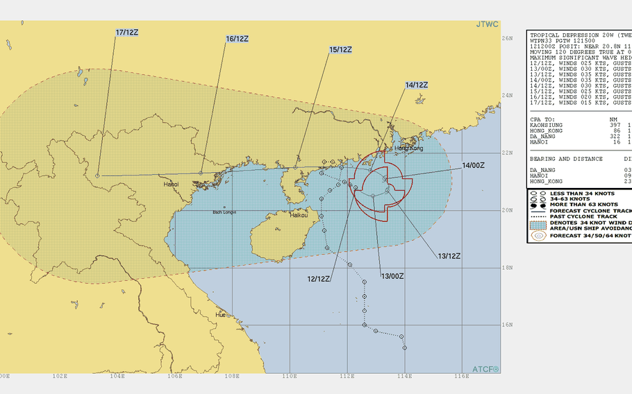
Noon Wednesday, Aug. 15, Hong Kong time: All tropical cyclone warning signals have been canceled for Hong Kong. Tropical Storm Bebinca continues moving west and is forecsat to skirt the southeast coast of China before making landfall over Vietnam around mid-day Friday. This is the final report on Bebinca.10:30 p.m. Tuesday, Aug. 14, Hong Kong time: Closest point of approach for Tropical Storm Bebinca to Hong Kong has come and gone. Now, Bebinca has arced west and begun headed toward southeastern China and Vietnam. At 8 p.m., Bebinca was 102 miles south-southwest of Hong Kong, crawling west at 3 mph and had weakened to 40-mph sustained winds and 52-mph gusts. Strong Wind Signal 3 remains raised for Hong Kong for the moment.1:30 p.m. Tuesday, Aug. 14, Hong Kong time: Strong Wind Signal 3 has been raise by the Hong Kong Observatory due to the proximity of Tropical Storm Bebinca. Bebinca is doing a slow crawl north near Hong Kong and has intensified to 46-mph sustained winds and 58-mph gusts. It doesn't appear for the moment that Signal 8 will be raised, but that depends on how close Bebinca comes to Hong Kong.Joint Typhoon Warning Center projects Bebinca to pass 44 miles southwest of Hong Kong at 1 a.m. Wednesday, then head west through southeastern China into Vietnam over the next few days.10:20 p.m. Monday, Aug. 13, Hong Kong time: Bebinca has been upgraded to a tropical storm and according to the Joint Typhoon Warning Center has reached peak intensity, 40-mph sustained winds and 52-mph gusts.Standby Signal 1 remains raised for Hong Kong. The Hong Kong Observatory stated it will keep tabs on Bebinca, but the chances of upgrading to Strong Wind Signal 3 were low. Bebinca remains forecast to curve west, 103 miles southwest of Hong Kong at 5 p.m. Tuesday, then skirt the southeast coast of China, make landfall and dissipate south of Hanoi later this week.1 p.m. Monday, Aug. 13, Hong Kong time: Folks might remember Tropical Storm Son-tinh last month and its odd path into Vietnam, back over water and south of Hong Kong. That's the track 20W appears to be taking. It's headed east at the moment, but getting set to curve west and pass 100 miles south-southwest of Hong Kong at 7 p.m. Tuesday. Standby Signal 1 remains raised for Hong Kong.10:20 p.m. Sunday, Aug. 12, Hong Kong time: A new tropical depression has spawned east of Hainan Island and is forecast to pass 100 miles south of Hong Kong at 2 p.m. Tuesday as a tropical storm, packing 40-mph sustained winds and 52-mph gusts at center.
Standby Signal 1 has been raised by the Hong Kong Observatory; there’s a chance that Strong Wind Signal 3 may be raised sometime Monday.
