()
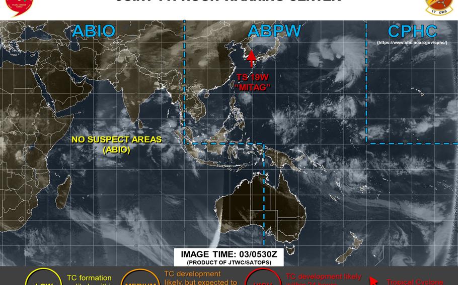
6:10 p.m. Thursday, Oct. 3, Japan time: Tropical Storm Mitag continues to transition into a sub-tropical gale-force cold-core low and is forecast to pass 130 miles south of Misawa Air Base late Friday evening. This is the final report on Mitag.12:40 p.m. Thursday, Oct. 3, Korea time: Tropical Cyclone Condition of Readiness All Clear has been directed for Daegu/Area IV at 11 a.m., Kunsan Air Base at 11:35 a.m. and Chinhae Naval Base at 12:40 p.m., according to spokesmen and official Facebook pages for all three regions. At 9 a.m., Tropical Storm Mitag was 143 miles east of Yongsan Garrison and had accelerated, moving northeast at 27 mph, packing 46-mph sustained winds and 58-mph gusts. Mitag has ended its visit to the Korean peninsula and moved offshore into the Sea of Japan (East Sea). Mitag has begun conversion to a sub-tropical low, but will still maintain gale-force strength, 52-mph sustained winds and 63-mph gusts as it crosses the Sea of Japan and make secondary landfall over north-central Honshu, passing 85 miles south of Misawa Air Base at 6 p.m. Friday.6:15 a.m. Thursday, Oct. 3, Korea time: Foundation Day in Korea began with Tropical Storm Mitag having made landfall over Mokpo on the peninsula's southwest coast about three hours before midnight Wednesday. It is now traversing the south-central part of Korea en route to the Sea of Japan (East Sea) and northeastern Japan. Closest point of approach to most U.S. facilities on peninsula has come and gone. At 3 a.m., Mitag was 66 miles southeast of Kunsan Air Base, headed northeast at 21 mph, still packing 46-mph sustained winds and 58-mph gusts at center. Kunsan, Daegu/Area IV and Chinhae Naval Base remain in Tropical Cyclone Condition of Readiness 1. Schools are on a 2-hour delay at Camps George and Walker in Daegu, while most facilities at Fleet Activities Chinhae will close Thursday, save for Turtle Cove and medical which will operate with short staffs. As the day progresses, Mitag is forecast to push back over the Sea of Japan, take a more east-northeasterly track and cut across north-central Honshu in Japan, passing 106 miles south-southeast of Misawa Air Base as a cold-core low with gale-force winds of 46 mph at center.6:30 p.m. Wednesday, Oct. 2, Korea time: U.S. bases in Daegu/Area IV are in Tropical Cyclone Condition of Readiness 1. Destructive winds of 58 mph or greater are anticipated within 12 hours.
Schools at Camps Walker and George are on a two-hour delay on Thursday, according to Daegu’s official Facebook page. The elementary school on Camp George will open at 9:30 a.m. and the middle-high school on Camp Walker at 10:30 a.m. Bus pickups will also be delayed 2 hours.
At this point, no other disruptions to Area IV operations, services, transportation or facilities are anticipated. Impact to Area IV from Tropical Storm Mitag is expected until 4 p.m. Thursday. Gusts up to 75 mph and up to 6 inches of rain are forecast.
Fleet Activities Chinhae remains in TCCOR 1 and will see closures to most of its facilities on Thursday, including the Exchange, commissary, bank and post office. Mission essential personnel only are expected to report for duty. The Turtle Cove and medical will be open, but with reduced staff.
5 p.m. Wednesday, Oct. 2, Korea time: Tropical Storm Mitag continues to weaken rapidly as it continues its path northeast toward forecast overnight landfall over Korea's southwest coast, according to the Joint Typhoon Warning Center. On the TCCOR scoreboard, Kunsan Air Base remains in Tropical Cyclone Condition of Readiness 1 and Chinhae Naval Base and Daegu/Area IV in TCCOR 2. The latter two may upgrade as a precaution, but JTWC indicates that destructive winds are not forecast at this time. At 3 p.m., Mitag was 209 miles south-southwest of Kunsan, headed north-northeast at 17 mph, packing 52-mph sustained winds and 63-mph gusts at center. If Mitag stays on its present heading, it's forecast to come ashore late Wednesday evening over Mokpo on Korea's southwest coast, then knife its way across the peninsula and push back out over water in the Sea of Japan (East Sea) by mid-day Thursday. JTWC projects Mitag to pass 52 miles south-southeast of Kunsan, 23 miles north-northwest of Daegu and 64 miles northwest of Chinhae between 1 and 6 a.m. Thursday, still packing 46-mph sustained winds and 58-mph gusts at center. Mitag is forecast to transition to gale-force cold-core low as it rolls through the Sea of Japan, making a near-direct hit on Misawa Air Base in northern Japan with 46-mph winds.1:45 p.m. Wednesday, Oct. 2, Korea time: Kunsan Air Base has directed Tropical Cyclone Condition of Readiness 1. Destructive winds of 58 mph or greater are anticipated within 12 hours. Get your safe on, Wolf Pack!Noon Wednesday, Oct. 2, Korea time: Tropical Storm Mitag has begun accelerating northeast toward a forecast rendezvous overnight Wednesday into Thursday morning along the southwest coast of the Korean peninsula. At 9 a.m., Mitag was 368 miles southwest of the port city of Pusan on Korea's southeast coast, moving northeast at 18 mph and holding steady at 63-mph sustained winds and 81-mph gusts.Fleet Activities Chinhae and U.S. Army Garrison Daegu each remain in Tropical Cyclone Condition of Readiness 2. Meanwhile, Fleet Activities Sasebo on Japan's southwest coast has directed TCCOR All Clear, as Mitag is forecast to pass only within 202 miles northwest of Sasebo Naval Base. If Mitag stays on its present course, it's forecast to gradually weaken as it moves rapidly northeast, crashing ashore near Mokpo on Korea's southwest coast, still packing 58-mph sustained winds and 75-mph gusts as it makes landfall overnight Wednesday into Thursday morning. Joint Typhoon Warning Center projects Mitag to pass 59 miles south-southeast of Kunsan Air Base, 57 miles north-northeast of Chinhae and 13 miles north of Daegu between 4 and 9 a.m. Thursday before pushing back over water into the Sea of Japan (East Sea). From there, Mitag is forecast to convert to a sub-tropical low and pass 40 miles south of Misawa Air Base in northeastern Japan, bringing gale-force winds of up to 46 mph.6:15 a.m. Wednesday, Oct. 2, Korea time: Tropical Storm Mitag continues to weaken gradually as it begins to curve northeast, headed toward landfall overnight Wednesday on Korea's southwest coast and forecast to cut across the south-central part of the peninsula.Chinhae Naval Base in southeastern Korea remains in Tropical Cyclone Condition of Readiness 2; that could be upgraded later this morning or early afternoon. Fleet Activities Sasebo in southwestern Japan in TCCOR Storm Watch. At 3 a.m., Mitag was 480 miles southwest of Korea's southeast port city of Pusan and had slowed considerably, heading north-northeast at 8 mph and weakened to 63-mph sustained winds and 81-mph gusts. Joint Typhoon Warning Center projects Mitag to accelerate and make landfall around 3 a.m. Thursday near Mokpo on Korea's southwest coast, still packing 58-mph sustained winds and 75-mph gusts at center as it roars ashore. Mitag is forecast to pass 46 miles south-southeast of Kunsan Air Base, 22 miles north-northwest of Daegu, 66 miles north-northwest of Chinhae and 215 miles northwest of Sasebo Naval Base between 3 and 9 a.m. Thursday before exiting into the Sea of Japan (East Sea). From there, Mitag is forecast to complete transition to cold-core low and make a near-direct hit on Misawa Air Base in northeastern Japan just past midnight Friday with gale-force winds up to 46 mph.11 p.m. Tuesday, Oct. 1, Korea time: Fleet Activities Chinhae has directed Tropical Cyclone Condition of Readiness 2 in advance of Mitag, which has been downgraded to a tropical storm. Destructive winds of 58 mph or greater are anticipated within 24 hours. According to U.S. Army Garrison Daegu's official Facebook page, U.S. bases in Area IV, the southeastern corner of the Korean peninsula, can expect impact from Mitag from 2 p.m. Wednesday to late Thursday evening. Winds along Korea's south coast are forecast to reach 58 to 69 mph with 3 to 6 inches of rain forecast. Other bases in Area IV can expect 40- to 52-mph winds and 3 to 4 inches of rain. For the moment, no closures, disruption or other major impact to Area IV operations, services, transportation and facilities are expected, though that can change. At 9 p.m., Mitag was 473 miles south-southwest of Kunsan Air Base, South Korea, headed almost due north at 15 mph and had weakened to 69-mph sustained winds and 86-mph gusts at center. If Mitag stays on its present heading, it's forecast to arc toward the Korean peninsula over the next two days, making landfall about midnight Wednesday near Mokpo along Korea's southwest coast, then burrow its way through the south-central portion of the peninsula. JTWC projects Mitag to pass 32 miles south of Kunsan, 45 miles north of Daegu, 87 miles north-northwest of Chinhae and 230 miles northwest of Sasebo Naval Base in southwestern Japan between 3 and 9 a.m. Thursday, still packing 52-mph sustained winds and 63-mph gusts at center. Fleet Activities Sasebo remains in TCCOR Storm Watch. Mitag remains forecast to move back out over water into the Sea of Japan (East Sea) after its trek through Korea, transition into a sub-tropical low and pass directly through Misawa Air Base in northern Japan at tropical depression-strength at 5 a.m. Saturday.6 p.m. Tuesday, Oct. 1, Korea time: Typhoon Mitag continues to weaken as it keeps pushing north and prepares for its arc toward the Korean peninsula, where it's forecast to remain a significant tropical storm as it threads the needle between Kunsan Air Base and Daegu/Area IV on Thursday. U.S. bases in Korea's Area IV, including Daegu and Chinhae Naval Base, remain in Tropical Cyclone Condition of Readiness 3, while Sasebo Naval Base in southwestern Japan remains in TCCOR Storm Watch. Expect upgrades to TCCORs for Area IV overnight Tuesday into Wednesday. At 3 p.m., Mitag was 546 miles south-southwest of Kunsan, moving almost due north at 17 mph and had weakened to 75-mph sustained winds and 92-mph gusts, about three-fourths of its intensity just 12 hours earlier. If Mitag remains on its present heading, it's forecast to continue weakening as it arcs toward peninsula and make landfall over Mokpo on Korea's southwest coast about midnight Wednesday. Joint Typhoon Warning Center projects Mitag to still be packing 52-mph sustained winds and 63-mph gusts as it rams ashore. Mitag is forecast to pass 53 miles south-southeast of Kunsan, 23 miles north-northwest of Daegu, 63 miles northwest of Chinhae and 208 miles northwest of Sasebo between 3 and 9 a.m. Thursday, Foundation Day in Korea. JTWC projects Mitag to continue weakening and converting to a sub-tropical low as it presses across the Sea of Japan (East Sea) toward a near-direct hit on Misawa Air Base at 5 a.m. Saturday at tropical depression-intensity.11:30 a.m. Tuesday, Oct. 1, Korea time: Looks like Foundation Day in Korea, Oct. 3, might be a gusty, rainy one, at least for U.S. bases in the southeast corner of the country, thanks to approaching Typhoon Mitag.U.S. Army Garrison Daegu and Chinhae Naval Base remain in Tropical Cyclone Condition of Readiness 3. Destructive winds of 58 mph or greater are possible within 48 hours. Sasebo Naval Base in southwestern Japan remains in TCCOR Storm Watch, while U.S. bases on Okinawa reverted to seasonal TCCOR 4 at 8 a.m. Tuesday. That's not to say typhoon-force winds are forecast for southern Korea; Mitag will remain a rather significant, strong tropical storm as it greets Korea on Thursday morning. Joint Typhoon Warning Center is projecting Mitag to still be packing 52-mph sustained winds and 63-mph gusts as it crosses the southern part of the peninsula. Area IV facilities on the country's south coast can expect winds up to 70 mph with 3 to 6 inches of rain, according to Daegu's official Facebook page. Other portions of Area IV can expect 40- to 52-mph winds and 1 to 5 inches of rain. At 9 a.m., Mitag was 610 miles southwest of Sasebo, headed almost due north at 14 mph and had weakened to a Category 1-equivalent cyclone, 86-mph sustained winds and 104-mph gusts. JTWC projects Mitag to arc northeast, just northwest of Cheju Island, and make landfall near Mokpo on Korea's southwest coast early Thursday morning. Mitag is forecast to make a near-direct hit on Daegu and pass 64 miles south-southeast of Kunsan Air Base, 44 miles north-northwest of Chinhae and 194 miles northwest of Sasebo between 6 a.m. and noon Thursday. From there, what's left of Mitag is forecast to cross the Sea of Japan (East Sea) and pass 61 miles south-southeast of Misawa Air Base as a sub-tropical low, with gale-force winds possible.10 a.m. Tuesday, Oct. 1, Japan time: U.S. bases on Okinawa have reverted to seasonal Tropical Cyclone Condition of Readiness 4. Forecaste closest point of approach by Typhoon Mitag to Okinawa has come and gone. 6 a.m. Tuesday, Oct. 1, Korea time: Fleet Activities Chinhae has directed Tropical Cyclone Condition of Readiness 3 as of 10 p.m. Monday. Destructive winds of 58 mph or greater are possible within 48 hours. Meanwhile, on the TCCOR scoreboard, Fleet Activities Sasebo and U.S. bases on Okinawa in southwestern Japan remain in TCCOR Storm Watch. Expect other U.S. bases on the Korean peninsula to issue TCCORs sometime today in advance of Typhoon Mitag, particularly Daegu, which Mitag has in its forecast crosshairs. Speaking of Mitag, staying just offshore of Taiwan has worked to its benefit. Joint Typhoon Warning Center reports Mitag has reached Category 2-equivalent intensity, 104-mph sustained winds and 127-mph gusts, and could remain quite powerful should it reach the Korean peninsula, which appears likely. At 3 a.m., Mitag was 629 miles southwest of Sasebo, moving due north at 19 mph. JTWC reports Mitag has reached peak intensity and should gradually ramp down as it arcs northeast. But it's due to remain a powerful tropical storm, 63-mph sustained winds and 81-mph gusts, at forecast landfall around midnight Wednesday near Mokpo on Korea's southwest coast. JTWC projects Mitag to make a near-direct hit on Daegu, and pass 62 miles south-southeast of Kunsan Air Base, 48 miles north-northwest of Chinhae and 198 miles northwest of Sasebo between 4 and 10 a.m. Thursday. From there, it's back out over water into the Sea of Japan (East Sea), picking up the pace rapidly and possibly transitioning into a subtropical low. It's still forecast to remain a significant weather event as it passes 46 miles south of Misawa Air Base in northeastern Japan just past midnight Friday.6:30 p.m. Monday, Sept. 30, Japan/Korea time: Fleet Activities Sasebo has directed Tropical Cyclone Condition of Readiness Storm Watch in advance of Typhoon Mitag, which likely won't be a typhoon as it approaches Sasebo. Joint Typhoon Warning Center projects Mitag to pass 158 miles northwest of Sasebo at 10 a.m. Thursday as a tropical storm, packing 52-mph sustained winds and 63-mph gusts mostly affecting southeastern Korea. U.S. bases on Okinawa also remain in TCCOR Storm Watch, while Chinhae Naval Base in southeastern Korea, which stands to feel the majority of effects, remains in TCCOR 4. At 3 p.m., Mitag was 925 miles south-southwest of Kunsan Air Base, South Korea, moving due north at 13 mph and had reached peak forecast intensity, 86-mph sustained winds and 104-mph gusts at center. If Mitag remains on its current heading, it's forecast to brush just off Taiwan's and China's east coasts as it moves north, passing 60 miles east of Taipei at 1 a.m. Tuesday and 130 miles east of Shanghai at 4 a.m. Wednesday, weakening slightly as it begins curving northeast. JTWC projects Mitag to diminish gradually as it moves north into cooler waters near Korea's Cheju Island, making landfall near Yeosu port on Korea's south coast around mid-day Thursday. Mitag is forecast to make a near-direct hit on Chinhae, 104 miles southeast of Kunsan and 34 miles south-southeast of Daegu/Area IV between 8 a.m. and 2 p.m. Thursday, still packing 52-mph sustained winds and 63-mph gusts as it cuts across the south coast into the Sea of Japan (East Sea). From there, Mitag is forecast to maintain 46-mph sustained winds and 58-mph gusts as it moves toward the north coast of Japan's main island of Honshu, passing well north of U.S. bases in the Kanto Plain, but 55 miles south-southeast of Misawa Air Base at 8 a.m. Saturday. But much can change before that; it's five days out. Stay tuned.6 a.m. Monday,Sept. 30, Korea time: Mitag has been upgraded to a Category 1-equivalent typhoon by the Joint Typhoon Warning Center, and its latest forecast track now puts Daegu and U.S. bases in Area IV in its crosshairs. At 3 a.m., Mitag was 453 miles southwest of Kadena Air Base, Okinawa, moving northwest at 17 mph with 75-mph sustained winds and 92-mph gusts at center.Chinhae Naval Base in southeastern Korea remains in Tropical Cyclone Condition of Readiness 4, with other bases on the Korean peninsula sure to follow in the coming hours. U.S. bases on Okinawa remain in TCCOR Storm Watch. If Mitag stays on its present heading, it's due to skim the east coasts of Taiwan and China, passing 28 miles east of Taipei at 11 p.m. Monday and 67 miles east of Shanghai at 5 a.m. Wednesday, maintaining forecast peak intensity of 81-mph sustained winds and 98-mph gusts. The question remains, how much interaction with land in Taiwan and China will hinder or slow Mitag's intensity. The current JTWC forecast projects Mitag to curve northeast toward Korea, losing its punch along the way as it makes landfall 47 miles south of Kunsan Air Base at noon Thursday, still packing 58-mph sustained winds and 75-mph gusts. Mitag should lose some of its punch as it interacts with Korea's rugged terrain. Still, it's forecast to pass 10 miles north of Daegu, 59 miles north of Chinhae and 72 miles north of Busan between 5 and 6 p.m. Thursday and maintain tropical-storm strength, 52-mph sustained winds and 63-mph gusts, before pushing back out to sea. From there, Mitag is forecast to cross the Sea of Japan (East Sea) toward Japan's main island of Honshu, coming within 152 miles north of Yokota Air Base by 3 a.m. Saturday.7:30 p.m. Sunday, Sept. 29, Korea time: Kunsan Air Base could get the first visit to Korea by Tropical Storm Mitag, which is now forecast to cut across the south-central part of the peninsula from southwest to northeast come Thursday. Already, Chinhae Naval Base has directed Tropical Cyclone Condition of Readiness 4, with other bases on peninsula sure to follow suit in the coming hours or sometime Monday. U.S. bases on Okinawa remain in TCCOR Storm Watch, though the latest forecast track continues to push Mitag away from the island. At 3 p.m., Mitag was 516 miles south-southwest of Kadena Air Base, pushing northwest at 12 mph and had strengthened slightly, to 63-mph sustained winds and 81-mph gusts at center. Mitag's long three-day west-northwest track appears to have come to an end. If Mitag remains on its present heading, its long, wide arc toward Korea began Sunday afternoon. JTWC projects Mitag to skim the east coasts of Taiwan and China, passing 46 miles east of Taipei at midnight Monday and 81 miles east of Shanghai at 3 a.m. Wednesday at peak forecast intensity, 86-mph sustained winds and 104-mph gusts. JTWC did indicate that frictional effects from land interaction could slow or limit Mitag's intensification, but much of that rests with its track in the coming day or three. Mitag is forecast to maintain Category 1-equivalent strength, 75-mph sustained winds and 92-mph gusts as it crosses the southern edges of the Yellow Sea (West Sea) and makes landfall 24 miles south of Kunsan at 7 a.m. Thursday. From there, Mitag is forecast to pass 48 miles northwest of Daegu and 91 miles north-northwest of Chinhae between 10 a.m. and noon Thursday. JTWC projects Mitag to still be packing 52-mph sustained winds and 63-mph gusts as it passes Area IV, before what remains after all that land interaction hurtles back out over water into the Sea of Japan (East Sea) early Thursday evening.11:45 a.m. Sunday, Sept. 29, Japan/Korea time: U.S. bases on Okinawa have entered Tropical Cyclone Condition of Readiness Storm Watch regarding Tropical Storm Mitag. Mitag is not forecast to come anywhere near Okinawa; in fact, the latest Joint Typhoon Warning Center forecast track now projects Mitag to pass 331 miles west-northwest of Kadena Air Base at 8 a.m. Tuesday. However, Kadena's 18th Wing Weather Flight's wind-forecast timelines projects Kadena and Okinawa to receive naught more than 23-mph sustained winds and 35-mph gusts early Tuesday morning. Precautionary measure. Of course, that's for now; this is weather and a lot can yet change. For the moment, JTWC projects Mitag to skim the east coast of Taiwan, peak at 92-mph sustained winds and 115-mph gusts just after passing 60 miles east of Taipei at midnight Monday. Mitag is then forecast to arc northeast toward the Korean peninsula overnight Tuesday into Wednesday, still packing 58-mph sustained winds and 75-mph gusts after making landfall just south of Mokpo on Korea's southwest coast.Daegu and Area IV bases now appear to be donning the bull's-eye with Mitag forecast to make a near-direct hit on the area, 4 miles north at 8 a.m. Wednesday. Other forecast closest points of approach by Mitag are 71 miles southeast of Kunsan Air Base, 47 miles northwest of Chinhae Naval Base and 191 miles northwest of Sasebo Naval Base between 2 and 6 a.m. Wednesday. No upgraded TCCORs have been set for those areas yet. Beyond that, JTWC forecasts Mitag to move back over water in the Sea of Japan (East Sea) on Thursday; it remains to be seen if Mitag will affect any bases in central or northeast Japan.6:10 a.m. Sunday, Sept. 29, Korea time: U.S. bases in the southeast corner of South Korea could be in for the second tropical cyclone to hit the area in as many weeks, as Tropical Storm Mitag is forecast to arc over the area by midweek, according to the Joint Typhoon Warning Center. At 3 a.m., Mitag was 587 miles south of Kadena Air Base, Okinawa, headed west at 15 mph and holding steady at 58-mph sustained winds and 75-mph gusts. JTWC projects Mitag to reach Category 1-equivalent intensity early Monday morning and peaking at 92-mph sustained winds and 115-mph gusts, Category 2 strength, early Tuesday morning just after passing 68 miles east of Taipei. Mitag is then forecast to keep making a wide arc northeast into Wednesday, skimming Korea’s southern coast, still packing 63-mph sustained winds and 81-mph gusts as it passes 17 miles north of Chinhae Naval Base, 25 miles south of Daegu and 35 miles north of Busan between 1 and 3 a.m. Thursday.
Midnight Saturday, Sept. 28, Korea time: For now, it appears as if Okinawa is well out of harm’s way regarding Tropical Storm Mitag … and it’s Korea that’s pretty much in the crosshairs now, according to the Joint Typhoon Warning Center.
At 9 p.m., Mitag was 605 miles south of Kadena Air Base, moving west-northwest at 18 mph and had strengthened slightly, to 58-mph sustained winds and 75-mph gusts at center. JTWC projects Mitag to pass 329 miles west of Kadena at 1 a.m. Tuesday. Mitag’s forecast track has edge closer and closer to Taiwan in the last day or so. If it remains on its current course, JTWC projects Mitag to reach Category 1-equivalent typhoon strength by mid-evening Sunday, then pass 70 miles east of Taipei at mid-evening Monday as it peaks at 98-mph sustained winds and 121-mph gusts. Mitag is forecast to pass 114 miles east of Shanghai at 9 p.m. Tuesday. Next comes a forecast visit to the Korean peninsula, late Wednesday evening for most locales. Mitag is forecast to pass 64 miles southeast of Kunsan Air Base and 54 miles northwest of Chinhae Naval Base between 8 and 11 p.m. Wednesday, still packing 75-mph sustained winds and 92-mph gusts after making landfall near Mokpo on the southwestern corner of the Korean peninsula.
12:15 p.m. Saturday, Sept. 28, Japan time: Okinawa can breathe more of a sigh of relief, for a moment, at least, as Tropical Storm Mitag’s latest forecast track takes it further away from the island than previously reported. But Sasebo Naval Base and Chinhae Naval Base — and, to a lesser extent Marine Corps Air Station Iwakuni — remain due for a sideswipe from Mitag by middle of next week, according to the Joint Typhoon Warning Center.
At 9 a.m., Mitag was 772 miles south-southeast of Kadena Air Base, moving west-northwest at 26 mph and had strengthened to 46-mph sustained winds and 58-mph gusts. U.S. bases on Okinawa remain in seasonal Tropical Cyclone Condition of Readiness 4.
If Mitag remains on its present course, it’s now due to peak at 115-mph sustained winds and 144-mph gusts at 9 a.m. Tuesday, but pass 232 miles west-northwest of Kadena at 10 a.m. Tuesday, with Okinawa now outside of Mitag’s forecast 34-knot (39-mph) wind bands.
JTWC projects Mitag to head toward the Tsushima Strait and more or less split the difference between Sasebo and Chinhae, 57 miles southeast of Chinhae and 83 miles northwest of Sasebo between 5 and 9 p.m. Wednesday.
It’s due to pass 133 miles northwest of Iwakuni at 2 a.m. Thursday.
There remains something of a spread among model solutions, though track guidance and ensembles still agree generally on a track northwest of Okinawa and through the Tsushima Strait.
6:15 a.m. Saturday, Sept. 28, Japan time: 19W has been upgraded to a tropical storm by the Joint Typhoon Warning Center. Its latest forecast track edges it a bit closer to Okinawa than previously forecast.
At 3 a.m., 19W was 910 miles south-southeast of Kadena Air Base, headed west-northwest at 16 mph and had strengthened to 40-mph sustained winds and 52-mph gusts. U.S. bases on Okinawa remain in seasonal Tropical Cyclone Condition of Readiness 4. If 19W continues on its present course, it’s forecast to peak at Category 3-equivalent intensity, 115-mph sustained winds and 144-mph gusts at 3 a.m. Monday, just before it makes forecast closest point of approach to Kadena, 183 miles west at 10 a.m. Tuesday, with Kadena right at the edge of 19W’s forecast 34-knot (39-mph) wind band.Kadena’s long-range forecast calls for peak winds to affect Okinawa on Tuesday, southerly sustained winds of 33 mph with gusts up to 59 mph and 80-percent chance of rain and thunderstorms. All that could change as 19W approaches. JTWC forecasts 19W to maintain Category 2-equivalent winds as it passes 34 miles northwest of Sasebo Naval Base, 108 miles southeast of Chinhae Naval Base and 77 miles northwest of Marine Corps Air Station Iwakuni between 4 and 7 p.m. Wednesday.
12:15 a.m. Saturday, Sept. 28, Japan time: Tropical Depression 19W remains forecast to strengthen and move rapidly west-northwest, then arc around Okinawa and make its way toward Sasebo Naval Base and Marine Corps Air Station Iwakuni by middle of next week., according to the Joint Typhoon Warning Center. At 9 p.m. TD 19W was 965 miles south-southeast of Kadena Air Base, Okinawa, moving west-northwest at 17 mph and had strengthened to 35-mph sustained winds and 46-mph gusts. U.S. bases on Okinawa remain in seasonal Tropical Cyclone Condition of Readiness 4; no recommendation has been made to upgrade to TCCOR 3 at the moment, an official with Kadena’s 18th Wing Weather Flight said. If TD 19W remains on its present heading, it’s forecast to head northwest the next two days, reaching Category 1-equivalent intensity at mid-evening Sunday. JTWC then projects TS 19W to curve north, peaking at 104-mph sustained winds and 127-mph gusts as it passes over Ishigaki at mid-evening Monday, then northeast, passing 201 miles west of Kadena at 3 p.m. Tuesday, holding onto peak forecast intensity as it makes its way toward the Tsushima Strait, almost mirroring Tropical Storm Tapah’s path earlier this month. Next, TD 19W is due to pass 45 miles northwest of Sasebo, 101 miles southeast of Chinhae Naval Base in southeastern Korea and 162 miles northwest of Iwakuni between 8 p.m. and 9 p.m. Wednesday, JTWC projects.Model track guidance and the GFS and CMC ensembles continue to agree in general on a track north and northeast around or close to Okinawa and toward southwestern Japan, but there continues to be a vast spread among model solutions. Stay tuned. Much can change; it’s still very early in the life of a young storm.6:15 p.m. Friday, Sept. 27, Japan time: Say hello to the 19th numbered tropical cyclone of the northwest Pacific's season. And for the moment, it appears as if it might spare of Okinawa, but give Sasebo Naval Base quite the hard time, though it's very early in the game to say definitively. A lot can change.Tropical Depression 19W was 1,042 miles southeast of Kadena Air Base and 582 miles west of Andersen Air Force Base, Guam, at 3 p.m. Friday, moving almost due west at 24 mph. Joint Typhoon Warning Center projects TD 19W to keep moving northwest and reach Category 1-equivalent strength at mid-afternoon Sunday. TD 19W is then forecast to make a wide circle north, then northeast, passing 210 miles west of Kadena at noon Tuesday, peaking a 104-mph sustained winds and 127-mph gusts at storm's center. For the moment, Okinawa appears to be outside of TD 19W's forecast wind bands. It's Sasebo, and to a lesser extent Chinhae Naval Base, that might face the bigger worry. TD 19W is forecast to weaken as it keeps making the northeast arc, coming within 59 miles northwest of Sasebo and 145 miles southeast of Chinhae at 3 p.m. Wednesday, still packing 86-mph sustained winds and 104-mph gusts. More precise closest points of approach should be known in the next day or so. It's very early in the life of a young storm, so naturally, there's a vast spread among model solutions, 305 miles three days out and 552 miles five days out, the end of the JTWC forecast period. Model track guidance and the GFS and CMC ensembles do agree in general on a northeast track around Okinawa toward Sasebo. For now, U.S. bases on Okinawa remain in seasonal Tropical Cyclone Condition of Readiness 4. There's no immediate recommendation to upgrade TCCOR at the moment, according to Kadena's 18th Wing Weather Flight. It's wait and see at the moment.11:30 p.m. Thursday, Sept. 26, Japan time: A tropical cyclone formation alert has been issued on disturbance 91W Invest by the Joint Typhoon Warning Center. 91W was 72 miles south-southwest of Guam at 11:30 p.m. and is forecast to head west-northwest over the next couple of days, followed by a curve north and northeast toward Okinawa and southwestern Japan by early next week.Model track guidance and the GFS and CMC ensembles generally agree on a track toward Okinawa by Monday or Tuesday, with a spread among model solutions, strength and track speeds. More should be known when JTWC issues its first warning on 91W.6:30 a.m. Thursday, Sept. 26, Japan time: A rainy, gusty visitor could be on its way toward southwestern Japan in early October.
Forecasters are keeping an eye on 91W Invest, a disturbance developing southeast of Guam that could track toward Okinawa and possibly Sasebo Naval Base and Marine Corps Air Station Iwakuni in the coming days.
It’s early, and model track guidance and the GFS and CMC ensembles do show some disparity among solutions. But they generally agree on a track toward southwestern Japan. Something to keep an eye on.
