()
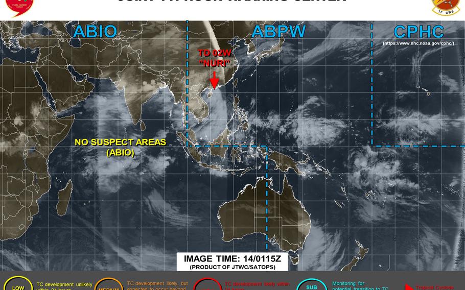
11 a.m. Sunday, June 14, Hong Kong time: Nuri has been downgraded to a tropical depression by the Joint Typhoon Warning Center. Standby Signal 1 was raised by the Hong Kong Observatory at 10:40 a.m. Nuri made landfall at about 8 a.m. just west of Yangjiang, southwest of Hong Kong and is headed inland and to forecast dissipation. This is Storm Tracker's final report on Nuri.10:40 p.m. Saturday, June 13, Hong Kong time: Tropical Storm Nuri remains on course to pass about 110 miles southwest of Hong Kong around 4 a.m. Sunday, holding steady at 40-mph sustained winds and 52-mph gusts, according to the Joint Typhoon Warning Center. Landfall should follow about four hours later as a tropical depression.Strong Wind Signal 3 remains raised by the Hong Kong Observatory. Unless Nuri unexpectedly curves toward the city and/or the winds increase significantly, chances of the wind signal being raised are low. Expect a final update on Nuri late Sunday morning.4:50 p.m. Saturday, June 13, Hong Kong time: Nuri has been upgraded to a tropical storm by the Joint Typhoon Warning Center. But it's already reached its JTWC-forecast peak of 40-mph sustained winds. Meanwhile, Strong Wind Signal 3 remains raised for Hong Kong, and the Hong Kong Observatory doesn't anticipate raising the signal at this point. At 2 p.m., Nuri was 191 miles south-southeast of Hong Kong, moving northwest at 15 mph, having strengthened to 40-mph sustained winds and 52-mph gusts. If Nuri continues on its current course, it's due to pass 105 miles southwest of Hong Kong at 2 a.m. Sunday at the same intensity. Landfall remains forecast for about 8 a.m. Sunday.3:40 p.m. Saturday, June 13, Hong Kong time: Strong Wind Signal 3 has been issued by the Hong Kong Observatory at 3:40 p.m. Saturday. Winds between 25 and 40 mph now forecast.11:15 a.m. Saturday, June 13, Hong Kong time: Standby Signal 1 remains in effect for Hong Kong. The Hong Kong Observatory reports that it plans to issue Strong Wind Signal 3 between 2 and 4 p.m. Saturday.Tropical Depression Nuri continues on its wobbly path generally northwest and is forecast to make landfall southwest of the city early Sunday morning. At 8 a.m., Nuri was 262 miles south-southeast of Hong Kong, moving north-northwest at 17 mph and still holding steady at 35-mph sustained winds and 46-mph gusts. If it remains on its current course, Nuri is forecast to peak within 12 hours at 46-mph sustained winds and 58-mph gusts. Joint Typhoon Warning Center projects Nuri to pass 82 miles southwest of Hong Kong about 2 a.m. Sunday and make landfall six hours later. JTWC reports a spread of about 80 miles among model solutions. 10:30 p.m. Friday, June 12, Hong Kong time: Standby Wind Signal 1 has been raised for Hong Kong in advance of the forecast passing by Tropical Depression Nuri 115 miles southwest of the city around midnight Saturday. At 8 p.m., Nuri was 378 miles southeast of Hong Kong, according to the Joint Typhoon Warning Center, moving west-northwest at 15 mph and holding steady at 35-mph sustained winds and 46-mph gusts at center. Standby Signal 1 was raised at 8:20 p.m. by the Hong Kong Observatory. It reports that Signal 1 should remain in effect for some time, and if winds and sea swells increase, it will consider raising Strong Wind Signal 3 sometime Saturday. If Nuri remains on its current course, it's forecast to peak at 52-mph sustained winds and 63-mph gusts at mid-evening Saturday, just before forecast passage about four hours later. JTWC projects landfall over southeastern China about 8 a.m. Sunday.5 p.m. Friday, June 12, Hong Kong time: Little change to Tropical Depression 02W. It has begun arcing northwest on a forecast course taking it about 115 miles southwest of Hong Kong early Sunday, packing 63-mph sustained winds and 81-mph gusts at center, according to official reports. At 2 p.m., as-yet-unnamed 02W was 445 miles southeast of Hong Kong, headed west-northwest at 17 mph holding steady at 35-mph sustained winds and 46-mph gusts, according to the Joint Typhoon Warning Center. No tropical cyclone warning signal has yet been raised for Hong Kong by the Hong Kong Observatory. Its forecast track pretty much mirrors that of JTWC.Noon Friday, June 12, Hong Kong time: The second numbered storm of the northwest Pacific's tropical cyclone season spawned early Friday just west of the Philippines' northernmost main island of Luzon. Its early forecast track places it just southwest of Hong Kong early Sunday morning, according to the Joint Typhoon Warning Center. At 8 a.m., Tropical Depression 02W was 135 miles northwest of Metro Manila and 888 miles southwest of Kadena Air Base, Okinawa, moving west-northwest at 16 mph packing 35-mph sustained winds and 46-mph gusts. All tropical cyclone wind signals for the Philippines have been lifted, according to the national weather authority PAGASA. Still, expect quite a bit of rain in Luzon over the next day or so. If 02W remains on its current course, it's forecast to pass 140 miles southwest of Hong Kong at about 2 a.m. Sunday, most likely as a tropical storm, packing 58-mph sustained winds and 75-mph gusts at center. But it's early yet; it could intensify as it heads through the South China Sea. No tropical cyclone warning signal has been raised for Hong Kong by the Hong Kong Observatory. Its forecast track is similar to that of JTWC's. Okinawa for the moment appears to be well out of harm's way.U.S. bases on island remain in seasonal Tropical Cyclone Condition of Readiness 4. And the annual rainy season for the island has been declared over by Japan Metorological Agency.11 p.m. Thursday, June 11, Philippines time: A tropical cyclone formation alert has been issued for disturbance 98W Invest by the Joint Typhoon Warning Center. Tropical Cyclone Wind Signal 1 has been issued for areas of Luzon, the Philippines' northernmost island, by the national weather authority PAGASA. Its initial forecast track takes the disturbance, labeled Tropical Depression ButchoyPH by PAGASA, in the general direction of Hong Kong by mid-day Sunday.Model track guidance shows a similar track, as do best tracks for the GFS and CMC forecast ensembles, the latter showing some outliers depicting a track north and east toward Kyushu in southwestern Japan. Nothing for Okinawa to be concerned about at the moment, but Storm Tracker will keep close watch on the system. U.S. bases on Okinawa remain in seasonal Tropical Cyclone Condition of Readiness 4. If this becomes a named tropical system by Japan Meteorological Agency measure, it would be called Nuri, Malaysian for parraquet.3 p.m. Wednesday, June 10, Hong Kong time: 98W Invest continues struggling to develop just off the tip of Samar Island in the Philippines' Visayan region. It remains a medium area for development in the next 24 hours, according to the Joint Typhoon Warning Center.Model track guidance shows 98W crossing Luzon, the Philippines' northernmost main island, over the next two to three days, then head toward southeastern China in Hong Kong's general direction over the next five to six days. No tropical cyclone warning signals are posted yet for the Philippines, according to the national weather authority PAGASA, and no warning signals have been posted for Hong Kong, according to the Hong Kong observatory. The GFS forecast ensemble's best track shows 98W on course for Hong Kong five days out. As for Okinawa, it appears to be out of harm's way for now. Only a few outliers in the CMC forecast ensemble indicate a possible track east-northeast, curving around Okinawa toward Kyushu. It's still early, though; the disturbance has only been on the grid for a couple of days. Much can change. Stay tuned. U.S. bases on Okinawa remain in seasonal Tropical Cyclone Condition of Readiness 4.6 p.m. Monday, June 8, Philippines time: After a few weeks of relative quiet on the tropical cyclone front, a new disturbance, labeled 98W Invest, is forming east of the Philippines.
For the moment, model track guidance and the GFS and CMC forecast ensembles indicate 98W might take the same general path that Typhoon Vongfong did last month, northwest either over or north of Luzon.
From there, it’s awfully hard to tell what 98W might do, though for the moment, Okinawa appears to be out of harm’s way. Of course, that could change, as this thing has just surfaced.
U.S. bases on Okinawa remain in seasonal Tropical Cyclone Condition of Readiness 4.
