Storm Tracker
Tropical Depression 34W (Man-yi), #17 FINAL
Stars and Stripes
November 19, 2018
Typhoon Man-yi has peaked at 104-mph sustained winds and 127-mph gusts, according to the Joint Typhoon Warning Center. (Joint Typhoon Warning Center)
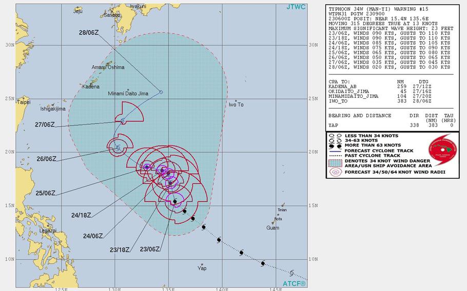
1 p.m. Tuesday, Nov. 27, Japan time: Man-yi has been downgraded to a tropical depression by the Joint Typhoon Warning Center and continues moving northeast, forecast to pass some 380 miles southeast of Kadena Air Base, Okinawa, at 5 p.m. and die out later this week. This concludes PST's coverage of Man-yi.6:40 p.m. Monday, Nov. 26, Japan time: Man-yi has been downgraded to a tropical storm by the Joint Typhoon Warning Center. It continues on a northerly arc and remains forecast to pass well southeast of Okinawa late Tuesday. At 3 p.m., Man-yi was 523 miles southeast of Kadena Air Base and 955 miles west-northwest of Guam, headed northwest at 9 mph, still packing 52-mph sustained winds and 63-mph gusts. Tropical storm-force winds extend 100 miles from center, according to the National Weather Service on Guam. If Man-yi continues moving as forecast, it should pass 350 miles southeast of Kadena at about 7 p.m. Tuesday, holding steady at the same wind values, then continue northeast, dying out well away from any land masses. Man-yi, called Tomas by the Philippines' national weather authority PAGASA, re-entered the Philippines area of responsibility early Monday, but again is not expected to threaten any land.7:45 p.m. Sunday, Nov. 25, Japan time: Typhoon Man-yi has remained quasi-stationary through most of Sunday, but is preparing to begin a wide arc northwest, then northeast while steadily weakening over the next few days, then dying out as a weak tropical depression Wednesday southeast of Okinawa. At 6 p.m., Man-yi was 580 miles southwest of Iwo Jima and 705 miles west-northwest of Guam, still packing 92-mph sustained winds and 115-mph gusts. Typhoon-force winds extend 35 miles from center and tropical storm-force winds 115 miles, according to the National Weather Service on Guam. If Man-yi continues moving as forecast, it's due to steadily diminish as it heads north over cooler waters and through cooler, less-humid air, passing 320 miles southeast of Kadena Air Base as a weak tropical depression.8:15 p.m. Saturday, Nov. 24, Japan time: Typhoon Man-yi has slowed somewhat in its journey north and is weakening as it goes. Man-yi continues moving north, and remains forecast to arc west, then northeast before dying out well south of Okinawa, according to the Joint Typhoon Warning Center. At 3 p.m., Man-yi was 771 miles southeast of Kadena Air Base and crawling north-northeast at 4 mph, still packing 86-mph sustained winds and 104-mph gusts at center. If Man-yi keeps on its current course, it's due to keep weakening as it curves northeast. Closest point of approach to Kadena is forecast for 332 miles south-southeast at 3 p.m. Tuesday, as a weak tropical depression. Man-yi has tracked along the edges of the Philippines area of responsibility, and has been named Tomas by the national weather authority PAGASA. It is no threat to land, but PAGASA does report the northeast monsoon is creating rough seas, making travel risky along north and east Luzon and eastern Visayas.5 p.m. Friday, Nov. 23, Japan time: Happy Black Friday from Pacific Storm Tracker. There have been more than a few glances made toward the southeast and Typhoon Man-yi, which continues meandering north in Okinawa's general direction. Relax. It's getting too cool, in the air and the surrounding water, in and around Okinawa for the conditions to support a typhoon. Man-yi has peaked at 104-mph sustained winds and 127-mph gusts, according to the Joint Typhoon Warning Center, and it's forecast to gradually weaken as it makes its way over cool waters and a far-less-than-humid environment to the north. At 3 p.m., Man-yi was about 915 miles southeast of Kadena Air Base and 544 miles west-northwest of Guam, trudging northwest at 15 mph. If it remains on its present course, Man-yi is forecast to lurch northwest early Sunday, then arc northeast, passing some 300 miles south-southeast of Kadena about 9 p.m. Tuesday as a minimal tropical storm or a tropical depression. In other worse, much ado about little. And too far away to be of major consequence if it does reach Okinawa. Some gusts and showers, but nothing like the island saw with the two typhoons that passed through in September and October.Model guidance is all over the place regarding Man-yi; JTWC reports a spread of some 1,060 miles among model solutions five days out. GFS and CMC forecast ensembles' best tracks are also spread out. On another note: U.S. bases on Okinawa starting next Saturday, Dec. 1, will revert from seasonal Tropical Cyclone Condition of Readiness 4 to All Clear, until June 1 of next year.1:30 p.m. Thursday, Nov. 22, Guam time: Guam has resumed seasonal Condition of Readiness 4, according to Guam Homeland Security/Office of Civil Defense, and the tropical storm warning is no longer in effect for Guam and Rota, according to the National Weather Service on Guam. At 10 a.m., Typhoon Man-yi was 290 miles southwest of Guam, moving west-northwest at 31 mph, away from the Marianas, and had intensified to 86-mph sustained winds and 104-mph gusts, NWS and Joint Typhoon Warning Center reported. Typhoon-force winds continue to extend 40 miles from center, and tropical storm-force winds 175 miles northeast and 140 miles elsewhere, NWS reported. For the moment, Man-yi no longer appears to be a threat to any land mass. Model guidance and the GFS and CMC forecast ensembles each depict a brief turn north, then a northwest track resumption followed by a wide arc northeast. PST will keep an eye on it.9:15 a.m. Thursday, Nov. 22, Guam time: Happy Thanksgiving from Pacific Storm Tracker to one and all. Closest point of approach to Guam has come and gone. Man-yi, upgraded this morning to a Category 1-equivalent typhoon by the Joint Typhoon Warning Center, passed about 275 miles southwest of Andersen Air Force Base and some 250 miles southwest of Naval Station "Big Navy" at about 7 a.m. A tropical storm warning remains in effect for Guam and Rota, according to the National Weather Service. At 7 a.m., Man-yi was 260 miles south-southwest of Guam, moving west-northwest at 30 mph with 75-mph sustained winds and 92-mph gusts. Typhoon-force winds extend up to 40 miles from center, and tropical storm-force winds 175 miles northeast and 140 miles elsewhere, NWS reports. Guam remains in Condition of Readiness 2, while military bases on island remain in COR 3, according to Guam Homeland Security/Office of Civil Defense. Man-yi is forecast to continue moving northwest, peaking at 110-mph sustained winds and 132-mph gusts early Friday morning, long after Man-yi has departed the Marianas area. Model guidance remains somewhat scattered. The CMC forecast ensemble's best track shows a brief turn toward Okinawa and the Philippines before curving northeast, with several outliers.8 p.m. Wednesday, Nov. 21, Guam time: Governor Eddie Baza Calvo has placed Guam in Condtion of Readiness 2 as of 8 p.m. in anticipation of Tropical Storm Man-yi, according to Guam Homeland Security/Office of Civil Defense. In conference with Rear Admiral Shoshana Chatfield, commander, Joint Region Marianas, only the Government of Guam will be in COR 2. Military installations on the island will remain in COR 3.7:30 p.m. Wednesday, Nov. 21, Guam time: Could Okinawa be next on Tropical Storm Man-yi's itinerary? Doubtful, very doubtful, considering the time of year and considering sea-surface temperatures, ocean-heat content and the environment as a whole are much cooler than two months ago when Typhoon Trami bore down on the place. Still, the latest from the Joint Typhoon Warning Center is much different, and a tad more disquieting, from previous reports -- instead of a northeast curve, Man-yi is now forecast to head straight north, then northwest at the top of next week, though it's forecast to drastically weaken after it turns. In other words, relax. No super typhoon or anything of the sort on the way. The latest GFS forecast ensemble shows Man-yi making something of a loop west, then curving northeast by the middle of next week. The CMC ensemble depicts the northeast curve coming slightly closer to Okinawa. But again, don't expect anything drastic. As for the immediate, a tropical storm warning remains in effect for Guam and Rota, according to the National Weather Service on Guam. The islands remain in Condition of Readiness 3, though Guam Homeland Security/Office of Civil Defense says shelters will open in three locations at 8 p.m. and the islands can expect to go COR 2 sometime this evening. At 5 p.m., Man-yi was 495 miles southeast of Guam, heading west-northwest at 23 mph and had intensified to 63-mph sustained winds and 81-mph gusts. If Man-yi remains moving as forecast, it's due to pass 228 miles southwest of Andersen Air Force Base and 206 miles southwest of Naval Base "Big Navy" around noon Thursday. Tropical storm-force winds extend 110 miles from center, NWS reports.3:30 p.m. Wednesday, Nov. 21, Guam time: A tropical storm warning has been issued for Guam and Rota in advance of Tropical Storm Man-yi, according to the National Weather Service. Condition of Readiness 2 is expected to be declared for Guam sometime Wednesday evening, according to Guam Homeland Security/Office of Civil Defense.12:30 p.m. Wednesday, Nov. 21, Guam time: Tropical Storm Man-yi continues hurtling northwest at a rapid clip and remains forecast to rumble southwest of Guam come Thanksgiving afternoon, according to the Joint Typhoon Warning Center and the National Weather Service on Guam. A tropical storm watch remains in effect for Guam and Rota, NWS reports. Guam remains in Condition of Readiness 3, according to Guam Homeland Security/Office of Civil Defense. Man-yi at 10 a.m. was 630 miles southeast of Guam, headed northwest at 20 mph, packing 58-mph sustained winds and 75-mph gusts and continues intensifying as it moves northwest. NWS reports Man-yi could become a typhoon as early as Wednesday nght or Thursday morning.
Long-term model guidance and the GFS and CMC forecast ensembles continue to hint at a northeast curve, followed by a turn back northwest, possibly heading toward Okinawa, but not certain. Stay tuned.9 a.m. Wednesday, Nov. 21, Guam time: Man-yi has been upgraded to a tropical storm by the Joint Typhoon Warning Center as it makes its way toward Guam, which remains in Condition of Readiness 3, according to Guam Homeland Security/Office of Civil Defense. At 5 a.m., Man-yi was 675 miles southeast of Guam and had picked up forward speed, moving northwest at 23 mph, packing 52-mph sustained winds and 63-mph gusts at center. Tropical storm-force winds extend 75 miles from center, according to the National Weather Service on Guam. A tropical storm watch remains in effect for Guam. Man-yi could become a Category 1-equivalent typhoon by Wednesday evening and is forecast to peak as a Category 3-equivalent storm, 121-mph sustained winds and 150-mph gusts late Thanksgiving afternoon. The good news, if there is such a thing involving typhoons, is Man-yi is forecast to pass 182 miles southwest of Andersen Air Force Base and 160 miles southwest of Naval Station "Big Navy" early Thursday afternoon, with Guam forecast to be outside Man-yi's 50-knot (58-mph) destructive wind band. As to where Man-yi might head after the Marianas, model guidance shows a track in Okinawa's general direction a week or so out. GFS forecast ensemble's best track still shows a curve northeast away from Japan, as does the CMC ensemble, though some outliers also favor a track in Okinawa's general direction. Stay tuned. 12:45 a.m. Wednesday, Nov. 21, Guam time: Guam has entered Condition of Readiness 3 in advance of Tropical Depression 34W, according to Guam Homeland Security/Office of Civil Defense. Destructive winds of 58 mph or greater are possible within 48 hours. By the time the sun rises, there's every chance 34W will be labeled a tropical storm and bear the name Man-yi. For the moment, it remains a tropical depression, according to the Joint Typhoon Warning Center. Its track has wobbled back west-northwest and it's continuing its slow crawl in the general direction of Guam. At 12:30 a.m., 34W was 874 miles southeast of Andersen Air Force Base, moving west-northwest at 8 mph and had intensified slightly, to 35-mph sustained winds and 46-mph gusts. If 34W continues on its present course, it's forecast to reach Category 1-equivalent typhoon intensity by mid-morning Thursday, then strengthen to a Category 2-equivalent typhoon by evening, packing 98-mph sustained winds and 121-mph gusts at center. The good news is, Guam should be safely out of the way of 34W's forecast 50-knot (58-mph) destructive wind bands. JTWC projects 34W to pass 187 miles southwest of Andersen and 165 miles southwest of Naval Station "Big Navy" between 7 and 8 p.m. Thursday. A tropical storm watch remains in effect for Guam and Rota, according to the National Weather Service on Guam.Model guidance agrees on a continued northwest path, followed by a curve northeast around the northern Marianas Islands and south of Iwo Jima by the weekend.7:15 p.m. Tuesday, Nov. 20, Guam time: A tropical storm watch remains in effect for Guam and Rota in advance of Tropical Depression 34W, which has wobbled a bit west and remains on forecast track to pass southwest of Guam on Thanksgiving Day, according to the Joint Typhoon Warning Center. At 7 p.m., 34W was 920 miles southeast of Andersen Air Force Base and had slowed a bit, moving west-southwest at 11 mph and holding steady at 29-mph sustained winds and 40-mph gusts. 34W is forecast to intensify rapidly over the next couple of days, becoming a Category 1-equivalent typhoon early Thanksgiving morning, then passing 200 miles southwest of Andersen and 177 miles southwest of Naval Station "Big Navy" at 5 p.m. Thanksgiving evening.Model guidance agrees on a northwest track past Guam; the question being, how close it might come. Both the GFS and CMC forecast ensembles are in line with model guidance on a northwest track followed by a northeast curve around the Marianas in the coming days, peaking at 110-mph sustained winds and 132-mph gusts on the weekend. Stay tuned.2 p.m. Tuesday, Nov. 20, Guam time: A tropical storm watch for Guam and Rota has been issued by the National Weather Service on Guam.1:30 p.m. Tuesday, Nov. 20, Guam time: Tropical Depression 34W continues to consolidate and remains on forecast track to pass southwest of Guam on Thanksgiving Day, potentially as a Category 2-equivalent typhoon, according to the Joint Typhoon Warning Center. At 10 a.m., 34W was 950 miles southeast of Guam, moving northwest at 13 mph. If it remains on its current course, 34W is forecast to rumble 204 miles southwest of Andersen Air Force Base and 181 miles southwest of Naval Station "Big Navy" at noon Thursday, packing 92-mph sustained winds and 115-mph gusts. No watches, warnings or accelerated Conditions of Readiness have been issued -- yet. But those are coming, should 34W hold true to its current forecast track. Keep an eye on Guam Homeland Security/Office of Civil Defense's official Facebook page and the National Weather Service on Guam for up-to-date information.Model guidance, GFS and CMC forecast ensembles continue to agree on a track northwest past the Marianas, followed by a curve northeast.7:30 a.m. Tuesday, Nov. 20, Guam time: A new tropical cyclone has spawned in the Micronesian islands southeast of Guam, and could affect Guam come mid-day Thanksgiving as a Category 2-equivalent typhoon, according to the Joint Typhoon Warning Center.
At 7:15 a.m., Tropical Depression 34W was 1,007 miles southeast of Andersen Air Force Base, moving west-northwest at 10 mph. If it remains on its present path, 34W is forecast to pass 202 miles southwest of Naval Station “Big Navy” and 225 miles southwest of Andersen at 1 p.m. Thursday, packing 98 mph sustained winds and 121 mph gusts at center.
Initial model guidance agrees on a track northwest then a curve northeast around the Marianas over the Thanksgiving weekend; the question being how close 34W comes to Guam. Best tracks from the GFS and CMC forecast ensembles show similar.
But it’s very early in the life of a new storm. Stay tuned.