Not much change at the moment. Jongdari remains a tropical depression and on a southwesterly path, but the Joint Typhoon Warning Center's latest forecast track calls for a loop around to the west and toward China. (Joint Typhoon Warning Center)
Not much change at the moment. Jongdari remains a tropical depression and on a southwesterly path, but the Joint Typhoon Warning Center's latest forecast track calls for a loop around to the west and toward China. (Joint Typhoon Warning Center)
(www.noaa.gov)
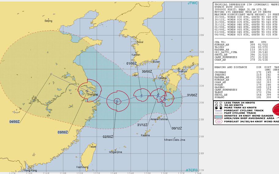
3 p.m. Wednesday, Aug. 1, Japan time: Jongdari remains a tropical depression, is forecast to peak at minimal tropical-storm strength at mid-day Thursday as it crosses the East China Sea, then come ashore just south of Shanghai at mid-morning Friday. At 9 a.m., Jongdari was 380 miles east of Shanghai, headed west-southwest at 11 mph. If it remains on its current course, Jongdari should peak at 40-mph sustained winds and 52-mph gusts at 9 a.m. Thursday, then make landfall at 9 a.m. Friday, dissipating as it moves over land. This is PST's final report on Jongdari.Midnight Tuesday, July 31, Japan time: As we exit July and head into August, Jongdari once more has weakened into a tropical depression. It has finished its wide loop south of Kyushu and is now headed west toward China's east coast. At 9 p.m., Jongdari was 214 miles south of Sasebo Naval Base and headed west at 15 mph, having weakened to 35-mph sustained winds and 46-mph gusts. If Jongdari continues on its present course, it's forecast to peak at 52-mph sustained winds and 63-mph gusts at mid-evening Thursday, about 12 hours before landfall south of Shanghai.Noon Tuesday, July 31, Japan time: Welcome back, Tropical Storm Jongdari. Jongdari re-intensified overnight Monday and continues to make a wide circle around southern Kyushu, preparing to make a run at China's East Coast, according to the Joint Typhoon Warning Center. At 9 a.m., 297 miles south-southeast of Sasebo Naval Base and 319 miles northeast of Kadena Air Base, Okinawa, headed east-northeast at 12 mph, with 40-mph sustained winds and 52-mph gusts. If Jongdari continues moving as forecast, it's due to complete its wide circle at mid-evening Tuesday, then make a wig-wag run west across the East China Sea, peaking at 63-mph sustained winds and 81-mph gusts just before landfall south of Shanghai at mid-day Friday. Okinawa should feel some of Jongdari's effects; it's forecast to pass 189 miles north of Kadena at 3 a.m. Thursday. But we're talking typical island wind gusts and a few showers. U.S. bases on Okinawa remain in seasonal Tropical Cyclone Condition of Readiness 4 and will likely continue to remain so. Asked if TCCOR Storm Watch was imminent, Kadena Air Base's 18th Wing Weather Flight told Stripes: "Not at this time."6 p.m. Monday, July 30, Japan time: Tropical Depression Jongdari has begun curving southeast, preparing to head across the East China Sea toward forecast landfall just south of Shanghai early Friday morning, according to the Joint Typhoon Warning Center. At 3 p.m., Jongdari was 195 miles south of Sasebo Naval Base, headed almost due south at 8 mph, holding steady at 35-mph sustained winds and 46-mph gusts. Fleet Activities Sasebo has directed Tropical Cyclone Condition of Readiness All Clear. If Jongdari continues moving as forecast, it's due to peak at 63-mph sustained winds and 81-mph gusts at mid-afternoon Thursday, just before coming ashore early Friday morning.Noon Monday, July 30, Japan time: Not much change at the moment. Jongdari remains a tropical depression and on a southwesterly path, but the Joint Typhoon Warning Center's latest forecast track calls for a loop around to the west and toward China. At 9 a.m., Jongdari was 148 miles south of Sasebo Naval Base, headed south-southwest at 10 mph with 35-mph sustained winds and 46-mph gusts. Jongdari is due to continue its very odd path and begin heading across the East China Sea at mid-morning Tuesday, peaking at 63-mph sustained winds and 81-mph gusts at mid-morning Thursday, still well off-shore. Jongdari is forecast to make a direct hit on Shanghai, China, early Friday morning. With Jongdari about to exit Japan, damage, flooding and injuries are still being assessed as Monday wears on. Thousands lost power and at least 24 people were hurt as Jongdari slammed into Japan over the weekend, according to multiple media reports. Jongdari made landfall at 1:20 a.m. Sunday over Shima, in Mie Prefecture just across the bay from Nagoya as a Category 1-equivalent typhoon. Rain continues to pour heavily on southern Kyushu and western Shikoku islands, on average about 2 inches per hour in some areas. Japan Meteorological Agency has issued warnings for landslides and flooding in low-lying areas. Hundreds of flights were canceled, affecting tens of thousands of passenger. Winds at the Tokyo International Airport at Haneda peaked at 50.6 mph. Flightaware.com and Flightstats.com reported at least 188 flights serving Haneda were canceled. More than 200,000 homes lost power at one point, according to the Asahi Shimbun, with Mie Prefecture hit hardest with 88,000 homes left darkened. Kasatoriyama saw the most rain over the weekend, 17.46 inches, followed by Minami-ise with 17.16, according to Accuweather.com. And this is an area hit hardest by heavy rain and winds that caused massive flooding and killed at least 225 people in the wake of Typhoon Prapiroon. Jongdari did bring relief from the recent heat wave to many portions of Japan, but the opposite occurred in the Tohoku region, with temperatures climbing to as high as 100 in Niigata and Kanazawa Prefectures. This all might not be done yet. Jongdari will hang around southern Kyushu for at least the next day or so.6:15 a.m. Monday, July 30, Japan time: Like the proverbial cat with nine lives, Tropical Depression Jongdari doesn’t appear to be dying out anytime soon Jongdari is but a tropical depression now, but it’s forecast to move south briefly, then loop back around to the west, re-intensifying and perhaps reaching Category 1-equivalent typhoon status again as it crosses the East China Sea. Landfall is forecast for early Friday close to Shanghai on China’s east coast.
At 3 a.m., Jongdari was 83 miles south of Sasebo Naval Base, moving south-southwest at 18 mph with 35-mph sustained winds and 46-mph gusts. Closest point of approach to Sasebo has come and gone, but the base remains in Tropical Cyclone Condition of Readiness Storm Watch.
That should continue for at least the rest of Monday, perhaps early Tuesday as Jongdari remains close by, then begins its journey west, peaking at 69-mph sustained winds and 86-mph gusts at 3 a.m. Thursday, perhaps stronger. Model guidance pretty much concurs with Joint Typhoon Warning Center’s assessment.
For the moment, Jongdari should not affect any land masses. It’s not forecast to turn around and harm Sasebo again, nor is it projected to come anywhere close to Okinawa, at least for right now. But Jongdari does bear considerable watching. Stay tuned.
11:30 p.m. Sunday, July 29, Japan time: Will Jongdari die out southwest of Kyushu Island as the Joint Typhoon Warning Center forecasts? Or will Jongdari keep fighting to stay alive and head west toward China's east coast? Jongdari has been downgraded to a tropical depression by JTWC, 35-mph sustained winds and 46-mph gusts and forecast to pass 28 miles southeast of Sasebo Naval Base at 1 a.m. Monday. Fleet Activities Sasebo remains in Tropical Cyclone Condition of Readiness Storm Watch and should remain so for much of Monday. JTWC projects Jongdari to crawl southwest off the ocast of Kyushu and die off about mid-morning Tuesday. But JTWC also reports there's a slight possibility it could regenerate about two days after that, retaining tropical-depression strength and then moving west over the East China Sea. Forecast models show Jongdari doing the same and also making landfall sometime Friday near Shanghai. Model guidance depicts Jongdari making a very unusual loop-the-loop near Tanegashima and Yakushima, two tiny islands near Kagoshima at Kyushu's southern tip, then heading west toward China. The GFS ensemble shows the same. A most unusual track. But then, that's why they call it weather; it can be so unpredictable at times, Stay tuned.6 p.m. Sunday, July 29, Japan time: Closes point of approach to Marine Corps Air Station Iwakuni by Tropical Storm Jongdari has come and gone. MCAS Iwakuni announced at 6 p.m. on its official Facebook page that the air station is now in Tropical Cyclone Condition of Readiness All Clear. Jongdari is now turning its attention southwest toward Sasebo Naval Base, and even the east coast of China might come into play, according to the Joint Typhoon Warning Center. While JTWC's forecast track calls for Jongdari to die off Tuesday afternoon southwest of Kyushu, model forecasts indicate a slight chance Jongdari could regenerate or remain alive and head toward China's east coast. At 3 p.m., Jongdari was 31 miles southwest of Iwakuni and had slowed slightly, headed west-southwest at 18 mph with 40-mph sustained winds and 52-mph gusts. Iwakuni's official Facebook page states that the base might continue to see winds up to 35 mph for the next day and a half. Meanwhile, Sasebo remains in TCCOR Storm Watch. If Jongdari continues moving as forecast, it's due to pass 27 miles southeast of Sasebo at 3 a.m. Monday as a tropical depression, 35-mph sustained winds and 46-mph gusts.Sasebo's weather portal calls for northerly winds of 12- to 18-mph sustained and 29-mph gusts, shifting southwest at 18- to 23-mph sustained gusting to 35 mph, then diminishing as daylight comes and Jongdari keeps moving southwest. As for Jongdari's long-term future, JTWC calls for it to dissipate Tuesday afternoon. But the GFS and CMC model ensembles call for extended life and a possible track into eastern China near Shanghai as late as Thursday afternoon. Stay tuned.Noon Sunday, July 29, Japan time: Yokota Air Base just became the last of the U.S. bases in the Kanto Plain to enter Tropical Cyclone Condition of Readiness All Clear, with Tropical Storm Jongdari well west and out of the area. Marine Corps Air Station Iwakuni is currently getting a wet, windy visit from Jongdari; heavy rain forecast for early afternoon. It should exit the Iwakuni area rapidly and pay a similar call on Sasebo Naval Base late Sunday, according to the Joint Typhoon Warning Center. Base officials told Stripes that Iwakuni City issued a siren just before noon for possible evacuations due to flood- and landslide-prone areas. At 9 a.m., Jondari was 61 miles north-northeast of Iwakuni, trucking west at 26 mph and holding steady at 46-mph sustained winds and 58-mph gusts. If Jongdari continues moving as forecast, it's due to pass just 7 miles northwest of Sasebo at about midnight as a tropical depression, 35-mph sustained winds and 46-mph gusts. Iwakuni and Sasebo remain in Tropical Cyclone Condition of Readiness Storm Watch. Though it should be blustery and showery, destructive winds of 58 mph or greater are not forecast for either base. Jongdari is next forecast to re-emerge over water southwest of Kyushu and dissipate in the East China Sea late Monday. JTWC reports there's a slight chance Jongdari might regenerate and continue into China's east coast..10 a.m. Sunday, July 29, Japan time: With the threat of bad weather from Tropical Storm Jondgari having moved into western Japan, Naval Air Facility Atsugi entered Tropical Cyclone Condition of Readiness All Clear at 9 a.m. and Camp Zama followed at 10 a.m.
6 a.m. Sunday, July 29, Japan time: Jongdari has been downgraded to a tropical storm by the Joint Typhoon Warning Center.
It made landfall at 1:20 a.m. Japan time over Shima in Mie Prefecture, just across the bay from Nagoya, and continues westbound toward Marine Corps Air Station Iwakuni and Sasebo Naval Base.
At 3 a.m., Jongdari was 207 miles west-southwest of Yokota Air Base, moving almost due west at 24 mph and still packing 69-mph sustained winds and 86-mph gusts at center. Destructive 58-mph winds extend 58 miles northeast of center and 40 miles southwest, JTWC reports.
The bad news is, Jongdari remains on course for possible direct hits on Iwakuni and Sasebo. The good news is, only as middle-grade tropical storms.
Jongdari is due to pass 22 miles north-northwest of Iwakuni at 3 p.m. Sunday, with 52-mph sustained winds and 63-mph gusts at center; then 7 miles northwest of Sasebo at 4 a.m. Monday, with 46-mph sustained winds and 58-mph gusts; then back over water, in the East China Sea, where dissipation is forecast for early Tuesday morning south of Cheju Island.
Iwakuni and Sasebo remain in Tropical Cyclone Condition of Readiness Storm Watch. Though no announcement has officially been made, Yokota, Naval Air Facility Atsugi and Camp Zama remain in TCCOR Storm Watch, with the all clear expected at any time. Yokosuka Naval Base went all clear at 12:30 a.m.
12:40 a.m. Sunday, July 29, Japan time: Fleet Activities Yokosuka has directed Tropical Cyclone Condition of Readiness All Clear for Yokosuka Naval Base and its satellite properties. All other U.S. bases in the Kanto Plain remain in TCCOR Storm Watch; that could change any time Sunday morning.
11:30 p.m. Saturday, July 28, Japan time: Fare thee well, Tokyo. Iwakuni and Sasebo, here comes Jongdari.
Typhoon Jongdari is barely clinging to Category 1-equivalent strength and is making its goodbyes to the Tokyo-Kanto Plain area and headed west toward the interior of Japan's main island of Honshu, according to the Joint Typhoon Warning Center.
At 9 p.m., Jongdari was 110 miles southwest of Yokosuka Naval Base, heading almost due west at 22 mph, still packing 81-mph sustained winds and 98-mph gusts at center.
Yokosuka remains in Tropical Cyclone Condition of Readiness 2 and Naval Air Facility Atsugi, Camp Zama and Yokota Air Base in TCCOR Storm Watch for now; expect the all-clear to be issued sometime early Sunday
As Jongdari makes its way across Honshu, it's forecast to weaken, down to 52-mph sustained winds and 63-mph gusts as it passes 26 miles north of Marine Corps Air Station Iwakuni at 5 p.m. Sunday.
Iwakuni remains in TCCOR Storm Watch, as does Sasebo Naval Base. Jongdari is forecast to pass 41 miles north of Sasebo at 10 a.m. Monday as a tropical depression.
From there, Jongdari is forecast to die out south of Cheju Island. JTWC reports there is a chance Jongdari could regenerate at mid-week and head toward the China coast.
7 p.m. Saturday, July 28, Japan time: Closest point of approach by Typhoon Jongdari to U.S. bases in the Kanto Plain has drawn nigh, according to the Joint Typhoon Warning Center's latest forecast track.
Japan Meteorological Agency has issued a heavy wind warning for the Kanto Plain, with 40-mph sustained winds and 58-mph gusts from time to time through midnight as Jongdari continues tracking west.
At 3 p.m., Jongdari was 113 miles south-southeast of Yokosuka Naval Base, headed west-northwest at 28 mph packing 92-mph sustained winds and 115-mph gusts at center.
U.S. bases in the Kanto Plain remain in Tropical Cyclone Condition of Readiness Storm Watch, except for Yokosuka, which remains in TCCOR 2. Expect those to be lifted as Jongdari moves out of the area and the winds die down.
Jongdari remains forecast to plow through central Honshu, reaching Kyoto by 3 a.m. Sunday, rapidly weakening throughout the day and eventually dying out just south of Korea's Cheju Island at mid-afternoon Tuesday.
Jongdari is due to pass 55 miles north of Marine Corps Air Station Iwakuni at 7 p.m. Sunday as a tropical storm, 52-mph sustained winds and 63-mph gusts, then 82 miles north of Sasebo Naval Base at noon Monday, 40-mph sustained winds and 52-mph gusts at center. Both bases remain in TCCOR Storm Watch.
Noon Saturday, July 28, Japan time: Despite Typhoon Jongdari's latest forecast track's close proximity to the Tokyo-Kanto Plain area, destructive winds are no longer forecast for Naval Air Facility Atsugi, Camp Zama and Yokota Air Base.
They have each entered Tropical Cyclone Condition of Readiness Storm Watch. Yokosuka Naval Base remains in TCCOR 2 and could upgrade, considering it is the closest of U.S. Kanto Plain bases to Jongdari.
Though destructive winds are not forecast to occur at Atsugi, Zama and Yokota, there still exists the chance of danger since Jongdari does remain close by. Downed power lines, trees or tree limbs, heavy squalls which may cause flooding in low-lying areas, for example. Key to moving around is doing it with caution, especially where standing or rushing water is present.
At 9 a.m., Jongdari was 275 miles southeast of Yokosuka, tracking north-northwest at 26 mph, packing 98-mph sustained winds and 121-mph gusts at storm's center.
Winds at Yokosuka should come out of the north, then gradually shift to the southeast throughout Saturday into Sunday.; Expect 40- to 46-mph sustained winds and 63-mph gusts early in the afternoon, diminishing to 29- to 35-mph sustained and 46-mph gusts in the evening and into Sunday morning, becoming light and variable from there.
If Jongdari continues moving as forecast, it should rumble through the Izu Islands south of Tokyo by 9 p.m., cross the southern tip of the Izu Peninsula a short time later, then make landfall around Shizuoka, near Mount Fuji, about midnight, still packing 86-mph sustained winds and 104-mph gusts.
Jongdari is forecast to pass 43 miles southwest of Camp Fuji, 60 miles southwest of Yokosuka, 66 miles southwest of Atsugi and Zama and 78 miles southwest of Yokota between 9 and 11 p.m. Saturday.
Jongdari should next plow through the mountains of central Honshu, steadily weakening, passing 64 miles north of Marine Corps Air Station Iwakuni at 1 a.m. Monday, with 40-mph sustained winds and 52-mph gusts at center. Iwakuni remains in TCCOR Storm Watch.
So, too, does Fleet Activities Sasebo. Jongdari is forecast to reemerge over water into the Sea of Japan (East Sea) and pass 94 miles north of Sasebo at 10 p.m. Monday as a tropical depression before dying out in the Tsushima Strait.
6:15 a.m. Saturday, July 28, Japan time: Typhoon Jongdari’s latest forecast track edges back toward the Kanto Plain, which now can expect a heavier rain and wind event come Saturday evening. And Marine Corps Air Station Iwakuni can also expect a near-direct hit early Monday, according to the Joint Typhoon Warning Center.
U.S. bases in the Kanto Plain remain in Tropical Cyclone Condition of Readiness 2. Expect that to be upgraded any time Saturday morning to TCCOR 1, with TCCOR 1-C and/or 1-E following Saturday afternoon or evening, depending on how close Jongdari comes and how much heavy wind it brings.
At 6 a.m., Jongdari was 449 miles southeast of Yokosuka Naval Base, moving almost due north at 23 mph and had peaked at 104-mph sustained winds and 127-mph gusts. As it arcs northwest toward the Kanto Plain, Jongdari is forecast to gradually weaken, but passing the Kanto Plain packing 92-mph sustained winds and 115-mph gusts.
If Jongdari continues moving as forecast, it should pass 76 miles southwest of Camp Fuji, 88 miles southwest of Yokosuka Naval Base, 97 miles southwest of Naval Air Facility Atsugi and Camp Zama and 110 miles southwest of Yokota Air Base between 10 p.m. and midnight Saturday.
Yokosuka can expect 23- to 29-mph sustained winds and 40-mph gusts early Saturday morning, increasing to 35- to 40-mph sustained and 58-mph gusts at mid-morning, decreasing the 29- to 35-mph sustained and 52-mph gusts late afternoon and weakening from there, according to Yokosuka’s weather portal. This forecast could change, depending on how close Jongdari comes.
Jongdari is forecast to make landfall around Hamamatsu in central Honshu early Sunday morning, then track west over the rugged terrain of Honshu, weakening the system into a middling tropical storm, 40-mph sustained winds and 52-mph gusts, as it passes almost directly over Iwakuni at 1 a.m. Monday and 35 miles north of Sasebo Naval Base 21 hours later. Sasebo and Iwakuni remain in TCCOR Storm Watch.
Midnight Friday, July 27, Japan time: Little change to report. Typhoon Jongdari's latest Joint Typhoon Warning Center forecast track keeps it well offshore away from the Tokyo area, but moving ever closer to Marine Corps Air Station Iwakuni and Sasebo Naval Base.
At 9 p.m., Jongdari was 562 miles south-southeast of Yokosuka Naval Base, moving north-northeast at 18 mph with 110-mph sustained winds and 132-mph gusts at center. It's due to peak at 115-mph sustained and 144-mph gusts as it curves northwest toward Honshu, Japan's main island.
If Jongdari remains on its current course, it's forecast to pass 125 miles southwest of Camp Fuji, 137 miles southwest of Yokosuka, 145 miles southwest of Naval Air Facility Atsugi and Camp Zama and 159 miles southwest of Yokota Air Base between 10 p.m. Saturday and 1 a.m. Sunday.
Destructive winds should be well out of the Tokyo-Kanto Plain area. JTWC projects destructive 75-mph winds to extend 58 miles northeast of center and 58-mph winds to extend 86 miles northeast of center. That's well short of those U.S. bases.
Still, Yokosuka, Zama and Atsugi remain in Tropical Cyclone Condition of Readiness 2 and Yokota in TCCOR 3. Expect those to be upgraded sometime overnight Friday or Saturday morning. Please check previous reports for forecast winds at Yokosuka; they have not changed.
Jongdari remains forecast to make landfall over the Kii Peninsula south of Osaka at mid-morning Sunday, skimming through Shikoku Island and passing 37 miles south of Iwakuni at 2 a.m. Monday as a severe tropical storm, 69-mph sustained winds and 86-mph gusts at center.
Sasebo is next. The bad news there: JTWC forecasts a direct hit on Sasebo at 9 p.m. Monday. The good news, if there is such a thing with tropical cyclones: As a middling tropical storm, 52-mph sustained winds, 63-mph gusts, a tad less than at Iwakuni.
For the moment, Iwakuni and Sasebo remain in TCCOR Storm Watch. Given the forecast track, that could change and rather quickly Saturday morning.
From there, Jongdari is forecast to re-enter open water, over the East China Sea, pass south of Korea's Cheju Island and move in China's general direction.
6:15 p.m. Friday, July 27, Japan time: Typhoon Jongdari has picked up forward speed and continues intensifying as it prepares to make the arc northwest toward Honshu, Japan's main island, this weekend, according to the Joint Typhoon Warning Center's latest forecast track.
At 6 p.m., Jongdari was 651 miles south-southeast of Yokosuka Naval Base, hurtling northeast at 23 mph with 104-mph sustained winds and 127-mph gusts at center.
If Jongdari remains on its present course, it's due to curve northwest, peaking at 121-mph sustained winds and 150-mph gusts at mid-afternoon Saturday, then arc southwest of the Tokyo-Kanto Plain area and toward landfall over the southern tip of the Kii Peninsula south of Osaka early Sunday morning.
Jongdari remains forecast to be well offshore from the Tokyo area, passing 135 miles southwest of Camp Fuji, 151 miles southwest of Yokosuka, 158 miles southwest of Camp Zama and Naval Air Facility Atsugi and 170 miles southwest of Yokota Air Base between 9 and 10 p.m. Saturday.
U.S. bases in the Kanto Plain remain in Tropical Cyclone Condition of Readiness 2. Depending on Jongdari's forward speed and intensity, upgrade to TCCOR 1 could happen in the wee hours Saturday morning, with further upgrades contingent on the presence of destructive winds (or not).
Yokosuka remains the closest base facing Jongdari's potential destructive winds, which should roar out of the northeast Saturday morning, shifting southeast later in the day, according to the base's weather portal.
Winds should pick up Friday evening, 18- to 23-mph sustained and 30-mph gusts overnight into Saturday. That should increase to 35- to 40-mph sustained and 58-mph gusts early Saturday afternoon, picking up to 40- to 46-mph sustained and 63-mph gusts Saturday evening, decreasing to 35- to 40-mph sustained and 58-mph gusts overnight into Sunday and diminishing from there.
Then, there are Marine Corps Air Station Iwakuni and Sasebo Naval Base to consider. Though interaction with land and mountains in Honshu and Shikoku Islands should weaken Jongdari, it should still pass close enough to Iwakuni and Sasebo to make for a blustery start of next week.
Jongdari is forecast to pass 46 miles south of Iwakuni at 11 p.m. Sunday and make an almost-direct hit on Sasebo 19 hours later, as a severe tropical storm in both locales, which remain in TCCOR Storm Watch. Those could be upgraded, again depending on Jongdari's locale and intensity.
4:25 p.m. Friday, July 27, Japan time: Fleet Activities Sasebo is the latest base to issue a tropical cyclone condition of readiness, this one Storm Watch, in anticipation of Typhoon Jongdari's forecast arrival. Strong winds are expected Monday morning at Sasebo Naval Base and its satellite properties.
Sasebo joins Marine Corps Air Station Iwakuni, which is in TCCOR Storm Watch; and all U.S. bases in the Kanto Plain in TCCOR 2.
3 p.m. Friday, July 27, Japan time: Fleet Activities Yokosuka and its satellite properties have entered Tropical Cyclone Condition of Readiness 2, in anticipation of the passage of Typhoon Jongdari this weekend.
Destructive winds of 58 mph or greater are anticipated within 24 hours. Destructive winds are forecast to occur at 3 p.m. Saturday. Expect upgrade to TCCOR 1 at about 3 a.m. Saturday.
A high-wind warning is in effect from 7 a.m. Saturday to 9 a.m. Sunday. A small craft warning is in effect from 9 p.m. Friday to 7 a.m. Sunday, according to Yokosuka's Naval weather portal.
Winds should primarily be out of the northeast through midafternoon Saturday, shifting southeast until Jongdari leaves the area.
Winds should pick up Friday evening, 18- to 23-mph sustained and 30-mph gusts overnight into Saturday. That should increase to 35- to 40-mph sustained and 58-mph gusts early Saturday afternoon, picking up to 40- to 46-mph sustained and 63-mph gusts Saturday evening, decreasing to 35- to 40-mph sustained and 58-mph gusts overnight into Sunday and diminishing from there.
2 p.m. Friday, July 27, Japan time: Marine Corps Air Station Iwakuni has entered Tropical Cyclone Condition of Readiness Storm Watch, with the anticipated approach of Typhoon Jongdari early next week.
It's too early to say whether Iwakuni might experience destructive winds. Jongdari is forecast to pass 66 miles south of Iwakuni at 7 p.m. Sunday, still packing 92-mph sustained winds and 115-mph gusts at storm's center. Iwakuni might end up on the edge of Jongdari's forecast 50-knot windbands.
Sasebo Naval Base announced on its official Facebook page that there are currently no plans to upgrade TCCORs, and that Storm Watch might be the highest level, depending on Jongdari's intensity and forecast track. Jongdari's forecast to remain a significant tropical storm and pass 17 miles south of Sasebo at 5 p.m. Monday.
Meanwhile, U.S. bases in the Kanto Plain remain in TCCOR 3 for the moment. But with Jongdari forecast to pass quite a ways away from the Tokyo area, that could change to Storm Watch, or remain at TCCOR 3 as a precaution.
7:15 a.m. Friday, July 27, Japan time: With Typhoon Jongdari now forecast to pass 167 miles southwest of Yokosuka on Saturday evening, forecast winds for the naval base have been dialed back some by the base’s weather portal.
Winds should primarily be out of the northeast, picking up Friday evening, 18- to 23-mph sustained and 30-mph gusts overnight into Saturday. That should increase to 35- to 40-mph sustained and 58-mph gusts early Saturday afternoon, picking up to 40- to 46-mph sustained and 63-mph gusts Saturday evening, decreasing to 35- to 40-mph sustained and 58-mph gusts overnight into Sunday and diminishing from there.
6 a.m. Friday, July 27, Japan time: Jongdari has intensified into a Category 1-equivalent typhoon, but it continues to look more and more as though it won’t bother Tokyo as much as previously forecast.
Instead, Marine Corps Air Station Iwakuni and Sasebo Naval Base might be the ones to get a visit from Jongdari early next week as a tropical storm, according to the Joint Typhoon Warning Center’s latest forecast track.
At 5:45 a.m., Jongdari was approaching Iwo Jima just to its southeast, packing 81-mph sustained winds and 98-mph gusts. Jongdari was 800 miles south of Tokyo, headed northeast at 9 mph and getting set to curve northwest toward Japan’s main island of Honshu.
If Jongdari continues moving as forecast, Tokyo and U.S. bases in the Kanto Plain could well be out of harm’s way. It’s due to pass 173 miles southwest of Camp Zama and Naval Air Facility Atsugi, 185 miles southwest of Yokota Air Base, 167 miles southwest of Yokosuka Naval Base and 149 miles southwest of Camp Fuji between 7 and 8 p.m. Saturday.
Jongdari should still be packing 104-mph sustained winds and 127-mph gusts as it passes the Tokyo area, but those would be at storm’s center, with Jongdari’s forecast 64-knot (74-mph) and 50-knot (58-mph) wind bands quite a ways offshore.
For the moment, Yokosuka Naval Base’s weather portal calls for winds picking up to 18- to 23-mph sustained and 35-mph gusts overnight Friday into Saturday, 35- to 40-mph sustained and 58-mph gusts early Saturday afternoon, 52- to 58-mph sustained and 75-mph gusts early evening, 58- to 63-mph sustained and 81-mph gusts late Saturday evening into Sunday morning, diminishing from there.
JTWC forecasts Jongdari to make landfall over Wakayama Prefecture, south of Osaka, about 3 a.m. Sunday, still packing 86-mph sustained winds and 104-mph gusts, then weaken to a tropical storm, 52-mph sustained winds and 63-mph gusts, as it passes 18 miles north of Iwakuni at 9 p.m. Sunday and 42 miles north of Sasebo at 2 p.m. Monday.
U.S. bases in the Kanto Plain remain in Tropical Cyclone Condition of Readiness 3. That could be upgraded to TCCOR 2 or perhaps downgraded to TCCOR Storm Watch, depending on Jongdari’s forecast track in the coming hours. No TCCORs have been set yet for Iwakuni or Sasebo. Stay tuned to Storm Tracker, AFN Radio, your base’s official Facebook page or your commander’s access channels for the latest.
Midnight Thursday, July 26, Japan/Korea time: Tropical Storm Jongdari's forecast track continues edging further west of Tokyo with every passing update.
But as it does, the more places like Marine Corps Air Station Iwakuni, Sasebo Naval Base and even Pusan in southeastern Korea might be on Jongdari's itinerary early next week.
This is beginning to read like a broken record, but there does remain a spread in model guidance, with GFS still depicting a track close to Tokyo, while NAVGEM projects a path closer to Osaka in Japan's Kansai region.
At 11:30 p.m., Jongdari was 818 miles south of Tokyo and picking up forward speed, moving northeast at 13 mph and had strengthened to just below typhoon intensity, 69-mph sustained winds and 86-mph gusts.
If Jongdari continues moving as forecast, it's due to make an almost-direct hit on Iwo Jima, 12 miles northwest at about 4 a.m. Friday, just as it reaches Category 1-equivalent typhoon strength.
Jongdari is forecast to peak at mid-evening Friday at 110-mph sustained winds and 132-mph gusts at center as it makes a wide curve northwest toward west-central Honshu, drawing a bead on Mie Prefecture across the bay from Nagoya, 170 miles southwest of Tokyo.
Assuming Jongdari continues moving as forecast, it's due to pass 117 miles southwest of Yokosuka Naval Base, 122 miles southwest of Camp Zama and Naval Air Facility Atsugi, 98 miles southwest of Camp Fuji and 134 miles southwest of Yokota Air Base, still packing 92-mph sustained winds and 115-mph gusts as it rams ashore.
U.S. bases in the Kanto Plain remain in Tropical Cyclone Condition of Readiness 3. Fleet Activities Yokosuka's official Facebook page stated Yokosuka would enter TCCOR 2 at 3 p.m. Friday and that destructive winds are forecast to hit at 3 p.m. Saturday. As Jongdari cuts across western and central Honshu and interacts with the rugged terrain, it's forecast to rapidly lose its punch, holding at 46-mph sustained winds and 58-mph gusts as it passes 55 miles north of Iwakuni at 10 p.m. Sunday and 112 miles north of Sasebo 16 hours later. Even Pusan might get more than just a zephyr or three; Jongdari is forecast to pass 30 miles south of there at about 4 p.m. Monday as a tropical depression, 35-mph sustained winds and 46-mph gusts. An interesting path, to say the least. And it might not be done changing yet. Stay tuned.6 p.m. Thursday, July 26, Japan time: With every passing forecast track update, Tropical Storm Jongdari looks to be on course to spare Tokyo of its full wrath when it makes forecast landfall over central Honshu in Japan early Sunday. Although model guidance continues to tighten, there's still a spread of about 275 miles among model solutions. So while it's generally agreed that Jongdari is headed in Tokyo's general direction, it's looking more and more like landfall will happen near Hamamatsu, about 130 miles southwest of Tokyo. But that could continue to change. At 6 p.m., Jongdari was 860 miles south of Tokyo, headed northeast at 9 mph and holding steady at 63-mph sustained winds and 81-mph gusts. Tropical storm-force winds extend 105 miles southeast of center and 65 miles northwest, according to the National Weather Service on Guam. If Jongdari continues moving as forecast, it's due to make a direct hit on Iwo Jima at 5 a.m. Friday just as it reaches Category 1-equivalent typhoon strength, 81-mph sustained winds and 98-mph gusts at center. As it continues moving northeast, then arcs northwest in Tokyo's general direction, Jongdari is forecast to peak at 115-mph sustained winds and 144-mph gusts at about 3 a.m. Saturday, still well off shore. Landfall is forecast for about 6 a.m. Sunday near Hamamatsu, in west-central Honshu, Japan's main island. Jongdari is forecast to rumble 68 miles southwest of Camp Fuji, 94 miles southwest of Yokosuka Naval Base, Camp Zama and Naval Air Facility Atsugi and 107 miles southwest of Yokota Air Base between 10 p.m. and midnight Saturday. And Korea could be next on the itinerary. Jongdari is forecast to maintain tropical-storm intensity as it crosses Honshu and edges back into the Sea of Japan (East Sea), and is even forecast to make secondary landfall over southeastern Korea, passing 23 miles south of Pohang and 38 miles northeast of Pusan between 3 and 6 a.m. Tuesday. U.S. bases remain in Tropical Cyclone Condition of Readiness 3, with 58-mph sustained winds possible within 48 hours. Assuming Jongdari's forecast track remains in close proximity to the Kanto Plain, expect an upgrade to TCCOR 2 at mid-day Friday.3:20 p.m. Thursday, July 26, Japan time: Fleet Activities Yokosuka has joined all other U.S. bases in the Kanto Plain in entering Tropical Cyclone Condition of Readiness 3. Destructive winds of 58 mph or greater are possible within 48 hours.2:30 p.m. Thursday, July 26, Japan time: Naval Air Facility Atsugi and Camp Zama have entered Tropical Cyclone Condition of Readiness 3 at 2:30 p.m. local time. Destructive winds of 58 mph or greater are possible within 48 hours. Expect Fleet Activities Yokosuka to follow by 6 p.m.Noon Thursday, July 26, Japan time: Yokota Air Base entered Tropical Cyclone Condition of Readiness 3 at noon local time. Destructive winds of 58 mph or greater are possible within 48 hours. What does this mean for you? Please give this link a click, scroll down to TCCOR 3 and give that paragraph a read. If you can't open the link, here's the text version:TCCOR 3 – Destructive winds of 58 mph or greater are possible within 48 hours. Begin a general cleanup around homes and office. Bring inside or tie down those bicycles to a concrete structure. Take down the trampoline and move it inside. Do the same with the hibachi or barbeque. Even plastic pails can become dangerous projectiles in a storm. Note: Do NOT tape windows; these days, windows of both on- and off-base structures are coated to protect from UV rays and are also designed to withstand sustained destructive winds for extended periods. Taping them might damage them. If you’ve not visited the Exchange or commissary, now’s the time to do so, to avoid the late rush.12:15 p.m. Thursday, July 26, Japan time: Might the Tokyo area and U.S. bases on the Kanto Plain catch a break from Tropical Storm Jongdari? Given the latest Joint Typhoon Warning Center forecast track, and the fact that it continues edging west of Japan's capital, that just might be the scenario come the weekend. At noon, Jongdari was 920 miles south of Tokyo, tracking almost due east at 9 mph and had strengthened slightly, to 63-mph sustained winds and 81-mph gusts, just shy of Category 1-equivalent typhoon strength. If Jongdari continues moving as forecast, Iwo Jima can expect a gusty, showery early Friday morning. Jongdari is due to pass 16 miles northwest of Iwo Jima at 7 a.m. Friday, just as it crosses that threshold and becomes a typhoon, with 86-mph sustained winds and 104-mph gusts at center as it roars past. Peak intensity of 115-mph sustained winds and 144-mph gusts is forecast for 9 a.m. Saturday, as Jongdari is in the process of arcing northwest in Tokyo's general direction. But unlike previous reports here, Jongdari is now forecast by JTWC to graze the southern tip of Izu Peninsula, 80-some-odd miles southwest of Tokyo, then make landfall between Shizuoka and Hamamatsu in central Honshu. Jongdari is forecast to pass 46 miles southwest of Camp Fuji, 73 miles southwest of Yokosuka Naval Base, Camp Zama and Naval Air Facility Atsugi and 85 miles southwest of Yokota Air Base, still packing 92-mph sustained winds and 115-mph gusts. But that's at storm's center. It appears as if Jongdari's 64-knot (74-mph) and 50-knot (58-mph) wind bands might just miss those U.S. bases. It'll still be a showery, rainy weekend, but perhaps not quite as windy. U.S. bases on the Kanto Plain remain in Tropical Cyclone Condition of Readiness 4. Despite the forecast track adjustment, expect an upgrade to TCCOR 3, if nothing else as a precaution, later Thursday. And as has been the case throughout Jongdari's young life, there remains a vast spread among model solution. JTWC reports some models take Jongdari southwest toward Iwakuni, while one outlier depicts a track north-northeast of Tokyo. Stay tuned.6:30 a.m. Thursday, July 26, Japan time: Tokyo and U.S. bases in the Kanto Plain can still expect a showery, blustery Sunday. But the latest Joint Typhoon Warning Center forecast track now shows Tropical Storm Jongdari making landfall early Sunday morning over the Izu Peninsula southwest of Tokyo.
And much uncertainty remains regarding model guidance, with a spread among solutions stretching from the Izu Peninsula to the southwest to as far east as Sendai in northeastern Honshu.
It’s a matter of where Jongdari makes landfall that will determine the sort of conditions Tokyo faces on Sunday. And no matter where it rumbles ashore, it’s forecast to remain a powerful Category 2-equivalent typhoon, packing 104-mph sustained winds and 127-mph gusts at center.
At 6 a.m., Jongdari was 936 miles south of Tokyo, crawling north-northeast at 5 mph and had intensified to 58-mph sustained winds and 75-mph gusts.
If Jongdari continues moving as forecast, expect it to pass 50 miles northwest of Iwo Jima at 6 a.m. Friday just as it strengthens into a Category 1-equivalent typhoon, 86-mph sustained winds and 104-mph gusts. It’s due to peak at 115-mph sustained winds and 144-mph gusts about a day later, still well off-shore.
Forecast track and model guidance continue to project a northwest arc toward the Tokyo area, with landfall at about 3 a.m. Sunday a bit further west of the Tokyo area than previously reported. The GFS ensemble depicts a track over central and western Honshu, perhaps taking it close to Marine Corps Air Station Iwakuni. The CMC ensemble shows a track through central Honshu into the Sea of Japan early next week.
Jongdari is forecast to pass 32 miles southwest of Camp Fuji, 62 miles southwest of Yokosuka Naval Base, 71 miles southwest of Yokota Air Base and 61 miles southwest of Camp Zama and Naval Air Facility Atsugi between 3 and 7 a.m. Sunday, with all bases resting at the edge of Jongdari’s forecast 58-mph wind band.
U.S. bases remain in Tropical Cyclone Condition of Readiness 4. Expect that to be upgraded sometime Thursday afternoon and/or evening.
11:30 p.m. Wednesday, July 25, Japan time: U.S. bases in the Kanto Plain have been placed in Tropical Cyclone Condition of Readiness 4. Destructive winds of 58 mph or greater are possible within 72 hours. Tropical Storm Jongdari has strengthened slightly. But while Tokyo could still take a pounding early Sunday, it's now Camp Fuji, some 40 miles southwest of Tokyo, in the crosshairs, according to the Joint Typhoon Warning Center's latest forecast track. Jongdari is coming to the close of its fourth day of existence and while model guidance agrees on a track in Tokyo's general direction, there remains a spread of some 420 miles among model solutions. That's a rather wide swath across Japan's main island of Honshu. At 11:15 p.m., Jongdari was 955 miles south of Tokyo, crawling north-northeast at 7 mph and had intensified to 52-mph sustained winds and 63-mph gusts. Tropical storm-force winds extend 85 miles from center in the east semicircle and 45 miles west, according to the National Weather Service on Guam. If Jongdari remains on its present course, it's forecast to pass 43 miles northwest of Iwo Jima at 4 a.m. Friday as a Category 2-equivalent typhoon, 98-mph sustained winds and 121-mph gusts at center as it roars past. Jongdari is then forecast to peak as a Category 3-equivalent storm, 115-mph sustained winds and 144-mph gusts at center at about 9 p.m. Friday while it's still well off shore. It should retain Category 2-equivalent strength as Jongdari approaches the Tokyo area early Sunday. Jongdari is forecast to make a direct hit on Camp Fuji, and pass 30 miles southwest of Yokosuka Naval Base, Camp Zama and Naval Air Facility Atsugi and 39 miles southwest of Yokota Air Base between 5 and 7 a.m. Sunday, and still be packing 86-mph sustained winds and 104-mph gusts as it rams ashore. Expect Kanto Plain bases to enter TCCOR 3 sometime Thursday afternoon or evening. Fleet Activities Yokosuka's official Facebook page indicated that destructive winds are forecast to begin at 6 p.m. Saturday. As stated earlier, though, it remains uncertain precisely where Jongdari will end up. Both the GFS and CMC ensembles show quite a divide among solutions. Whichever way it goes, the intense heat of the last few days in central Japan could be a contributing factor toward keeping Jongdari strong as it slams ashore Sunday. Time to start preparing, hope for the best but expect the worst. Get your safe on, Tokyo!5:45 p.m. Wednesday, July 25, Japan time: Looks as if Tropical Storm Jongdari is indeed punching its ticket for a journey to the Tokyo area on Sunday, according to the Joint Typhoon Warning Center's latest track and model guidance. At 5:30 p.m., Jongdari was 994 miles south of Tokyo and had begun curving northeast, moving at 10 mph and holding steady at 46-mph sustained winds and 58-mph gusts. Tropical storm-force winds extend 130 miles from center in the northern semicircle and 85 miles south, according to the National Weather Service on Guam. Should Jongdari remain on its present heading, it's forecast to reach Category 1-equivalent strength, 81-mph sustained winds and 98-mph gusts, as it passes 33 miles northwest of Iwo Jima. Jongdari next is forecast to arc northwest, putting the Tokyo-Kanto Plain area dead in its sights, peaking at 110-mph sustained winds and 127-mph gusts at 3 p.m. Saturday, still well off shore, before making landfall early Sunday morning. Jongdari is due to pass 7 miles southwest of Yokosuka Naval Base, Camp Zama and Naval Air Facility and 16 miles west of Yokota Air Base between 5 and 7 a.m. Sunday, still packing Category 2-equivalent winds as it rams ashore. That arc should continue, leading Jongdari through the mountains and rough terrain of center Honshu before bursting back over water in the Sea of Japan late Monday afternoon. Forecast models are coming into much better agreement, The GFS ensemble depicts a track just northeast of the Kanto Plain, while the CMC ensemble projects landfall southwest of the Tokyo area.12:30 p.m. Wednesday, July 25, Japan time: Still a few days away, so a lot can change, but the latest Joint Typhoon Warning Center forecast track shows Tropical Storm Jongdari making a possible direct hit on Tokyo and U.S. bases in the Kanto Plain early Sunday morning. For the moment, U.S. bases in the Kanto Plain remain in Tropical Cyclone Condition of Readiness All Clear. That may change, and as early as first thing Thursday morning. For those new to the Kanto Plain or the Pacific in general, please give this a good read; plenty of detail about those TCCORs and the keys to surviving them: Preparation and communication. At noon, Jongdari was 989 miles south of Tokyo, still moving slowly north at 9 mph and had strengthened slightly, to 46-mph sustained winds and 58-mph gusts. Assuming Jongdari remains on its JTWC forecast track, it's due to curve northeast and pass 36 miles northwest of Iwo Jima at 6 a.m. Friday, packing 81-mph sustained winds and 98-mph gusts at center. Peak intensity of 110-mph sustained winds and 127-mph gusts is projected for about 27 hours later. Jongdari is then forecast to turn by the left flank northwest, arcing on a path that's projected to take it 11 miles southwest of Yokota Air Base, 17 miles northwest of Yokosuka Naval Base and 20 miles northeast of Camp Zama and Naval Air Facility Atsugi, still packing Category 1-equivalent winds as it slams ashore. Again, though, there remains a significant spread among forecast models. The GFS ensemble depicts a direct hit on Tokyo, while the CMC ensemble projects a track much farther southwest, Shikoku and western Honshu. One thing's clear: Jongdari will hit Honshu in one place or another. The question is where.6:30 a.m. Wednesday, July 25, Japan time: Jongdari has intensified into a tropical storm and remains on target to make landfall just northeast of Tokyo early Sunday morning, according to the Joint Typhoon Warning Center’s latest forecast track.
Jongdari is forecast by JTWC to remain a strong Category 1-equivalent typhoon when it comes ashore, packing 86-mph sustained winds and 104-mph gusts. It’s not something the Tokyo area has been accustomed to seeing in quite awhile; best to begin preparation early, hope for the best and expect the worst as Jongdari approaches.
At 6 a.m., Jongdari was 1,024 miles south of Tokyo, moving north at 11 mph and had strengthened to 40-mph sustained winds and 52-mph gusts.
If Jongdari continues moving as forecast, it should begin curving northeast later Wednesday afternoon, passing 28 miles northwest of Iwo Jima at 2 a.m. Friday, then peak at 110-mph sustained winds and 127-mph gusts about a day later, still well off shore and about a day before arriving in the Kanto Plain.
Jongdari should then make for a very blustery, showery early Sunday morning, coming ashore and passing 26 miles northeast of Yokota Air Base, 29 miles northeast of Yokosuka Naval Base and 35 miles northeast of Camp Zama and Naval Air Facility Atsugi between midnight Saturday and 2 a.m. Sunday.
Jongdari is a Korean word for skylark.
11:30 p.m. Tuesday, July 24, Japan time: It's fairly clear Tropical Depression 15W is headed for landfall somewhere over northeast Honshu, Japan's main island. The question being, where and when? Joint Typhoon Warning Center's latest forecast track continues taking 15W just northeast of the Tokyo area's U.S. bases late Sunday morning. But a look at model guidance provides a far less than definitive outlook. At 11:15 p.m., 15W was 1,109 miles south of Tokyo, moving almost due north at 11 mph, still holding steady at 35-mph sustained winds and 46-mph gusts. JTWC and the National Weather Service on Guam project 15W to intensify into a tropical storm sometime Wednesday. If 15W continues moving as forecast, it's due to curve northeast and make an almost-direct hit on Iwo Jima, just 6 miles north at 7 p.m. Thursday, packing 75-mph sustained winds and 92-mph gusts at center. A blustery, rainy night for the tiny historic outpost. From there, 15W is forecast to peak at 104-mph sustained winds and 127-mph gusts at 9 p.m. Friday, far away from land; then curve northwest and draw a bead somewhere over northeast Japan. JTWC projects 15W to pass 19 miles northeast of Yokota Air Base, 24 miles northeast of Yokosuka Naval Base and 29 miles northeast of Naval Air Facility Atsugi and Camp Zama between 9 and 11 a.m. Sunday, still packing 92-mph sustained winds and 115-mph gusts. But there remains a vast spread among model solutions. The GFS ensemble splits the difference between GFS and NAVGEM model tracks; the CMC ensemble remains confused, at best, spread as far east as Tokyo and west as Amami Island, 200 miles northeast of Okinawa. In other words, the only thing certain is uncertainty. 6 p.m. Tuesday, July 24, Japan time: Interesting possibilities are developing as Tropical Depression 15W continues its slow crawl north and keeps putting northeast Japan in its sights. The question being, where in northeastern Japan. Joint Typhoon Warning Center's latest forecast track still projects landfall in the Kanto Plain; but model guidance is divided, with GEM suggesting a route overTokyo and GFS indicating a possible track toward Misawa Air Base, of all places. At 6 p.m., 15W was 1,185 miles south of Tokyo, tracking north at 8 mph, holding steady at 35-mph sustained winds and 46-mph gusts. If 15W keeps moving as forecast, it's due to pass 22 miles northwest of Iwo Jima at about midnight Thursday as a Category 1-equivalent typhoon, 81-mph sustained winds and 98-mph gusts at center. 15W is due to intensify rapidly over the next day or so, peaking at 104-mph sustained winds and 127-mph gusts at mid-afternoon Friday before curving north or northwest toward Honshu. JTWC forecasts 15W to put U.S. bases in the Kanto Plain almost directly in its sights, 15 miles northeast of Yokota Air Base, 24 miles northeast of Camp Zama and Naval Air Facility Atsugi and 25 miles northeast of Yokosuka Naval Base between 11 a.m. and 1 p.m. Sunday, still packing 81-mph sustained winds and 98-mph gusts at center. U.S. bases in the Kanto Plain remain in Tropical Cyclone Condition of Readiness All Clear. Expect that to change late Wednesday evening or early Thursday morning. TCCOR 4 would be the first step, with destructive winds of 58-mph or greater possible within 72 hours. Earlier Tuesday, the GFS ensemble indicated a track toward Tokyo; now, it, too, is projecting a possible path to Misawa. The CMC ensemble suggests completely different things, a spread from just southwest of Tokyo to as far west as Amami island northeast of Okinawa. Misawa has proven to be a rare destination for tropical cyclones. Only once have destructive winds of 58 mph or greater hit the base, sending Misawa into TCCOR 1-E, back in late August 2016 when Tropical Storm Lionrock passed through the region. And last September, Tropical Storm Talim had Misawa back in TCCOR 1 for awhile. Bottom line: One never knows. We're talking weather, as unpredictable as the night is long.12:15 p.m. Tuesday, July 24, Japan time: Pssst ... Hey, Tokyo. Got some good news and some bad news. The good news: You might be getting a break from this week's incredibly hot weather. The bad news: It's in the form of a tropical cyclone, which if it keeps moving as forecast, could bring Category 1-equivalent winds to the Kanto Plain by mid-morning Sunday. Tropical Depression 15W remains far from land, but continues moving slowly in a northerly direction. At noon, it was 1,285 miles south of Tokyo, heading north-northwest at 12 mph, holding steady at 35-mph sustained winds and 46-mph gusts. It's forecast to intensify into a tropical storm sometime Tuesday evening, curve northeast and peak at 98-mph sustained winds and 121-mph gusts at mid-morning Friday, just after passing 38 miles northwest of Iwo Jima. 15W is then forecast to curve northwest and plow ashore at 9 a.m. Sunday, 18 miles north of Yokota Air Base and 26 miles north of Yokosuka Naval Base, Camp Zama and Naval Air Facility Atsugi, packing 75-mph sustained winds and 92-mph gusts at center. U.S. bases in the Kanto Plain remain in Tropical Cyclone Condition of Readiness All Clear; expect that to change to TCCOR 4 sometime Thursday.Midnight Monday, July 23, Japan time: Tropical Depression 15W remains on a collision course with Iwo Jima early Saturday morning. And the latest forecast track from the Joint Typhoon Warning Center indicates a possible turn toward Tokyo a couple of days after. At midnight, 15W was 550 miles west-northwest of Guam, 1,333 miles south of Tokyo and 904 miles southeast of Kadena Air Base, Okinawa, tracking north at 7 mph, holding steady at 35-mph sustained winds and 46-mph gusts. 15W is forecast to keep tracking north until early Thursday morning before curving northeast, passing 37 miles northwest of Iwo Jima at 8 p.m. Friday. JTWC then projects 15W to make a slight poleward turn, indicating a return to a northwest track in the late term. But JTWC and model guidance still indicate a massive spread among model solutions, as far west as Okinawa to as far east as central Honshu. The GFS ensemble depicts landfall just northeast of Tokyo, while the CMC ensemble spreads as far west as Shikoku to as far east as Hokkaido. Still very early in the life of a young storm. Much more should be known in the next two days or so.6:45 p.m. Monday, July 23, Japan time: This is why they call it weather, gang. It is famed for its unpredictability. One never knows from one day, sometimes one hour, to the next where a tropical cyclone may decide to head. That's definitely the case with Tropical Depression 15W, which earlier Monday appeared as if it would track toward Okinawa by this weekend. But its forecast track has made a sharp right turn northeast, starting Wednesday evening. And the latest model guidance indicates that Tokyo might be a possible destination early next week. At 6 p.m., Joint Typhoon Warning Center reported that 15W was 529 miles west-northwest of Guam, 944 miles southeast of Kadena Air Base and 1,380 miles south of Tokyo, crawling north at 6 mph and holding steady at 35-mph sustained winds and 46-mph gusts. If 15W remains on its new forecast track, it's due to strengthen into a Category 2-equivalent typhoon, 110-mph sustained winds and 132-mph gusts at center at mid-afternoon Saturday, about half a day after passing 56 miles northwest of Iwo Jima. Beyond that, models indicate a track in Tokyo's general direction, though there's a vast spread -- of about 1,400 miles, JTWC reports -- among solutions. Here's the GFS ensemble and the CMC ensemble. Just as all of what we thought Monday morning got blown up by afternoon, we could be looking at a different scenario come Tuesday. That's weather.1 p.m. Monday, July 23, Japan time: Still no definite answer regarding whether Tropical Depression 15W will head northwest toward Okinawa or northeast toward Japan's main islands in the coming days. Only things certain at this point is, 15W will continue heading north for the next couple of days, should strengthen into a tropical storm later Monday and peak at 92-mph sustained winds and 115-mph gusts by Saturday. At 12:30 p.m., 15W was 990 miles southeast of Kadena Air Base and 600 miles northwest of Guam, and had slowed considerably, trudging north at 6 mph, holding steady at 35-mph sustained winds and 46-mph gusts. Model guidance remains wide and varied. Joint Typhoon Warning Center projects that if 15W remains on its current path, it's forecast to get within 284 miles east-southeast of Kadena at 9 a.m. Saturday.Midnight Sunday, July 22, Japan time: So very much like most tropical cyclones in their infancy: The question being, where will Tropical Depression 15W head in the long term? The latest Joint Typhoon Warning Center forecast track has 15W headed in Okinawa's general direction. Initial model guidance takes 15W right over or close to Okinawa. The GFS ensemble? That's all over the lot. In short, it might take another day or so before models start coming into better agreement and it becomes more clear which way 15W will head. At 11:45 p.m. Japan time, JTWC reports 15W was 457 miles west of Guam and 1,042 miles southeast of Kadena Air Base, Okinawa, moving north at 8 mph, and had intensified slightly, to 35-mph sustained winds and 46-mph gusts. If it continues moving as forecast, JTWC projects 15W to move within 363 miles east-southeast of Kadena by 9 p.m. Thursday, packing 98-mph sustained winds and 121-mph gusts at center as it stands about halfway between Okinawa and Iwo Jima. Again, hard to say for sure if that's where it will end up. Stay tuned. PST has an eye on it.1 p.m. Sunday, July 22, Guam time: Of the five active tropical cyclones in the Pacific at the moment, one appears as if it might threaten Okinawa in the coming days – 15W, which just spawned overnight west of Guam.
At 1 p.m., Joint Typhoon Warning Center projected 15W to be 434 miles west of Guam and 1,150 miles southeast of Kadena Air Base on Okinawa, traveling northwest at 15 mph with 29-mph sustained winds and 40-mph gusts at center.
JTWC’s initial forecast track takes 15W northwest and in Okinawa’s general direction by late this week. If it remains on course, it would be 335 miles southeast of Kadena by mid-morning Thursday.
But it’s still very early in the life of a young storm – and model guidance is all over the lot at the moment. JTWC reports a spread of about 1,150 miles among model solutions at the moment. Much more should be known, and much more definitively, in the next couple of days.
Still, it appears as if Okinawa could be in for yet another wet, gusty weekend.
