()
Noon Wednesday, Feb. 14, Philippines time: Sanba remains a weak tropical depression, continuing on a west-southwesterly course that should take it over southern Palawan in the next several hours, according to the Joint Typhoon Warning Center. At 11 a.m., Sanba was about 500 miles south of Manila, headed west-southwest at 25 mph, holding steady at 29-mph sustained winds and 40-mph gusts. Sanba is forecast to peak at 40-mph sustained and 52-mph gusts at mid-morning Thursday as it tracks just south of Vietnam by weekend. Sanba is forecast by JTWC to track 152 miles south of Puerto Princesa on Palawan by early evening Tuesday. if It remains on its present path, it might likely miss Vietnam altogether, passing 190 miles south of Ho Chi Minh City by late afternoon Saturday. Tropical Storm Warning Signal 1 remains raised for Palawan, including the Camian and Cuyo islands, according to the Philippines' national weather authority PAGASA. Warning signals in Mindanao and Visayas have been lowered. This should be PST's final report on Sanba.5:30 a.m. Wednesday, Feb. 14, Philippines time: Tropical Depression Sanba continues to weaken as it arcs southwest, according to the Joint Typhoon Warning Center. It’s projected to pass further south of Puerto Princesa on Palawan than previous forecast and could miss Vietnam altogether.
At 2 a.m., Sanba was 432 miles south of Manila, headed west-southwest at 18 mph and had diminished to 29-mph sustained winds and 40-mph gusts. Sanba is back over open water and could strengthen over the next several hours; JTWC projects Sanba to peak at 40-mph sustained winds and 52-mph gusts after passing 95 miles south of Puerto Princesa at about 6 p.m. Wednesday.
JTWC forecasts Sanba to keep tracking west toward the southern tip of Vietnam, and depending on its movement could miss Vietnam altogether. Model guidance is divided at this point.
Some portions of Luzon, Visayas and Mindanao remain under Tropical Storm Warning Signal 1, according to the Philippines’ national weather authority PAGASA.
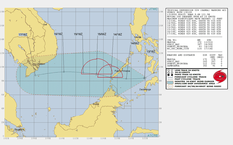
11 p.m. Tuesday, Feb. 13, Philippines time: Sanba has been downgraded to a tropical depression by the Joint Typhoon Warning Center and remains on target to exit Visayas and Mindanao, heading west toward the Philippines’ westernmost Palawan Island, then Vietnam by this weekend.
At 8 p.m., Sanba was 404 miles south-southeast of Manila and continuing what’s been a zig-zag course, now moving southwest at 17 mph and having diminished to 35-mph sustained winds and 46-mph gusts. Areas of Palawan, Visayas and Mindanao remain under Tropical Storm Warning Signal 1, according to the national weather authority PAGASA.
If it remains on its present course, Sanba is due to pass 158 miles north of Zamboanga, in southwestern Mindanao, at 2 a.m. Wednesday, then 44 miles south of Puerto Princesa on Palawan about 15 hours later. Sanba may become a tropical storm again soon after exiting Palawan, JTWC reports.
Sanba is then forecast to diminish as it crosses the South China Sea toward secondary landfall about 107 miles northeast of Ho Chi Minh City early Saturday evening.
4:45 p.m. Tuesday, Feb. 13, Philippines time: Sanba is barely clinging to tropical-storm status and has slowed somewhat as it heads west across the Bohol Sea toward Palawan and a forecast date with the South China Sea, according to the Joint Typhoon Warning Center. At 2 p.m., Sanba was 430 miles southeast of Manila, headed west at 12 mph, holding steady at 40-mph sustained winds and 52-mph gusts. Sanba is forecast to diminish some as it continues over the Philippines, then pick up strength after hitting the South China Sea, peaking at 46-mph sustained and 58-mph gusts at mid-afternoon Thursday. Tropical Storm Warning Signal 1 remains raised for areas of Palawan, southern Visayas and north-central Mindanao, according to the national weather authority PAGASA. If it remains on its present course, Sanba is due to pass 185 miles north of Zamboanga, in southwestern Mindanao, at 2 a.m. Wednesday, then make a near-direct hit on Puerto Princesa in Palawan about 17 hours later. Long-range projection calls for Sanba to make secondary landfall in Vietnam, just north of Nha Trang, at mid-afternoon Saturday as a tropical depression.11:30 a.m. Tuesday, Feb. 13, Philippines time: Tropical Storm Sanba has made landfall over Cortes, Surigao del Sur, northeast Mindanao and has begun tracking between Mindanao and Visayas.
Tropical Storm Warning Signal 2 has been canceled and Sanba could be downgraded to a tropical depression later Tuesday, according to PAGASA and Joint Typhoon Warning Center.
At 8 a.m., Sanba, called Basyang by PAGASA, was 463 miles southeast of Manila, tracking west-northwest at 18 mph, holding steady at 40-mph sustained winds and 52-mph gusts.
If Sanba continues tracking as forecast, it’s due to pass 228 miles north of Zamboanga, in southwest Mindanao, and 35 miles north of Puerto Princesa in Palawan.
Sanba may peak at 46-mph sustained winds and 58-mph gusts after heading back over the South China Sea toward Vietnam.
5:30 a.m. Tuesday, Feb. 13, Philippines time: Tropical Storm Sanba continues homing in on landfall over northeastern Mindanao and southern Visayas sometime Tuesday morning, according to the Joint Typhoon Warning Center. Tropical Storm Warning Signals have been raised and extended to western parts of the Philippines.
At 2 a.m., Sanba was 570 miles southeast of Manila, tracking northwest at 21 mph, holding steady at 40-mph sustained winds and 52-mph gusts. If it remains on its current course, Sanba is due to curve directly west, knifing between Mindanao and Visayas throughout the day Tuesday, exiting land early Wednesday morning over the Sulu Sea.
Sanba is forecast to pass further north of Zamboanga than previously forecast, 221 miles at midnight Tuesday, then 29 miles north of Puerto Princesa on Palawan at mid-afternoon Wednesday, peaking at 46-mph sustained winds and 58-mph gusts as it tracks into the South China Sea. Most of the high winds are confined to northern quadrants of Sanba, JTWC reports.
Tropical Storm Warning Signal 2 has been extended to western portions of Visayas while TSWS Signal 1 has been raised for portions of Palawan Island. Check here for a comprehensive list of places where warning signals are raised, according to the national weather authority PAGASA.
9:45 p.m. Monday, Feb. 12, Philippines time: As Tropical Storm Sanba edges closer to the Philiippines' largest island, Mindanao, it continues holding steady at 40-mph sustained winds and isn't forecast to exceed that, according to the Joint Typhoon Warning Center.
But heavy rain remains forecast for northern Mindanao and southern Visayas. Sanba is forecast to make landfall Tuesday morning over the Caraga region of east Mindanao and cross rapidly over the island into the Sulu Sea by Tuesday evening, JTWC and the national weather authority PAGASA reported.
At 8 p.m., Sanba was 477 miles east of Zamboanga, in southwest Mindanao, headed west-northwest at 18 mph, holding steady at 40-mph sustained winds and 52-mph gusts as it approaches land.
If it remains on its current track, Sanba is forecast to pass 117 miles north of Zamboanga at 2 a.m. Wednesday, weakening slightly as it makes its way over land, then 66 miles south of Puerto Princesa on Palawan Island.
The Dinagat Islands have been added to sites under Tropical Storm Warning Signal 2, according to PAGASA, with most of the rest of Mindanao and southern Visayas under TSWS 1.
Again, it's important to take special care to avoid flooding in low-lying areas and landslides in mountainous regions. Be safe, Philippines.
6:45 p.m. Monday, Feb. 12, Philippines time: Tropical Storm Warning Signal 2 has been expanded through Surigao and Agusan as Tropical Storm Sanba approaches Mindanao.4:45 p.m. Monday, Feb. 12, Philippines time: Tropical Storm Sanba continues to slow as it heads west toward forecast landfall Tuesday afternoon over eastern Mindanao. It is forecast to peak at just 46-mph sustained winds, according to the Joint Typhoon Warning Center. At 2 p.m., Sanba was 835 miles southeast of Manila and 1,000 miles west-southwest of Guam, headed almost due west at 17 mph, holding steady at 40-mph sustained winds and 52-mph gusts at center. Sanba is due to peak at 46-mph sustained and 58-mph gusts at 2 a.m. Tuesday. If Sanba remains on its current track, it's due to pass 104 miles north of Zamboanga, in southwest Mindanao, at 2 a.m. Wednesday, then 84 miles north of Puerto Princesa in Palawan, western Phiippines. Tropical Storm Warning Signal 2 has been raised for Surigao del Sur in Mindanao, according to the national weather authority PAGASA. Check here for TSWS Signal 1 in other parts of Mindanao and southern Visayas. Again, be especially watchful for heavy rain, flooding and possible landslides, especially in mountainous and low-lying areas. Best advice is to get to higher ground if possible before the heavy stuff hits.8 a.m. Monday, Feb. 12, Philippines time:It’s not so much high winds that appear to be the big worry with Tropical Storm Sanba, although 52-mph sustained winds and 63-mph gusts, projected to be the peak winds sometime later Monday, are not to be toyed with lightly. It’s heavy rain, which can trigger flooding and landslides in the regions of the Philippines which Sanba is targeting – Leyte and other sections of southern Visayas and northern portions of Mindanao, the Philippines’ largest island. Take special care in preparing for Sanba’s arrival; get toward higher ground, if necessary. Give a look at areas of the Philippines are in Tropical Storm Warning Signal 1, according to the national weather authority PAGASA. At 5 a.m., Sanba – called Basyang in the Philippines – was 925 miles west-southwest of Guam, headed due west at 13 mph with 40-mph sustained winds and 52-mph gusts at center, according to the National Weather Service on Guam.
If it remains on its present course, Sanba is due to pass 152 miles north of Zamboanga, in southwestern Mindanao, at 1 a.m. Wednesday, and 34 miles south-southwest of Puerto Princesa on Palawan Island about 18 hours later.
6 p.m. Sunday, Feb. 11, Philippines time: Tropical Storm Sanba is forecast to enter the Philippines area of responsibility Sunday evening. Tropical Storm Warning Signal 1 has been raised for parts of the eastern Philippines, according to the national weather authority PAGASA. At 5 p.m., Sanba was 785 miles west-southwest of Guam and had picked up forward speed again, moving almost due west at 18 mph, holding steady at 40-mph sustained winds and 52-mph gusts at center, according to the Joint Typhoon Warning Center and National Weather Service on Guam. If it remains on its current course, Sanba is due to pass 137 miles north-northeast of Zamboanga, in southwestern Mindanao, at 3 a.m. Wednesday, then 26 miles south of Puerto Princesa on Palawan Island 21 hours later. Sanba is forecast to peak at 52-mph sustained winds and 63-mph gusts at center at mid-afternoon Monday.2:30 p.m. Sunday, Feb. 11, Philippines time: So, will Tropical Storm 02W achieve typhoon intensity or will it not? According to the latest from the Joint Typhoon Warning Center, 02W is now forecast to peak only at 52-mph sustained winds and 63-mph gusts, far below what was forecast Sunday morning. At noon, 02W was 685 miles southwest of Guam, headed due west at 13 mph, about half the forward speed it had Sunday morning, and had diminished to 40-mph sustained winds and 52-mph gusts. The forecast track hasn't changed much; 02W is still due to cross northern Mindanao and southern Visayas in the central Philippines Tuesday and Wednesday, peaking at 52-mph sustained winds and 63-mph gusts on Monday. If 02W remains on its forecast path, it's due to pass 122 miles north-northeast of Zamboanga at 3 a.m. Tuesday, then 12 miles south of Puerto Princesa on Palawan Island about 22 hours later. Expect heavy rain with possible flooding and landslides from 02W as it makes its way through land early this week.
6 a.m. Sunday, Feb. 11, Philippines time: Looks like Mindanao might get the first typhoon of the northwest Pacific tropical cyclone season, according to the latest from the Joint Typhoon Warning Center. At 2 a.m., 02W was 710 miles southwest of Guam, moving due west at 29 mph but had intensified overnight, 52-mph sustained winds and 63-mph gusts at center. 02W is now forecast to peak at 86-mph sustained winds and 104-mph gusts just before making landfall Monday evening over eastern Mindanao, and retain typhoon strength as it crosses the north part of the Philippines’ largest island.
5 p.m. Saturday, Feb. 10, Philippines time: Looks like Tropical Depression 02W might edge more over central Mindanao in southern Philippines and less over the Visayas islands in the central part of the country, according to the latest from the Joint Typhoon Warning Center.
02W, which is not yet named, is not yet in the Philippines area of responsibility, according to the national weather authority PAGASA.
At 2 p.m., 02W was 460 miles south-southwest of Guam, headed west-southwest at 22 mph and remains weak and disorganized, 29-mph sustained winds and 40-mph gusts at center. It’s forecast to peak only at 46-mph sustained winds and 58-mph gusts at mid-afternoon Monday before making landfall over easter Zamboanga.
If it remains on its present course, 02W should pass 108 miles north of Zamboanga, much closer than previously reported, at 1 a.m. Wednesday, and 57 miles south-southwest of Puerto Princesa on western Palawan about 21 hours later. After weakening slightly, 02W is forecast to strengthen again as it makes its way back over water in the South China Sea.
10 a.m. Saturday, Feb. 10, Guam time:A small-craft advisory remains in effect until 6 p.m. Saturday for the Marianas islands as Tropical Depression 02W continues moving away from Guam westward toward forecast landfall between Visayas and Mindanao in the Philippines.
At 7 a.m., 02W, as yet unnamed, was 290 miles southwest of Guam, headed almost due west at 15 mph and had weakened to 29-mph sustained winds and 40-mph gusts. 02W is due to peak at 58-mph sustained winds and 75-mph gusts overnight Monday into Tuesday, passing 196 miles north of Zamboanga at 10 p.m. Tuesday and almost directly over Puerto Princesa at mid-morning Wednesday.
9 p.m. Friday, Feb. 9, Guam time: A new tropical depression has formed about 210 miles south of Agana, the capital of Guam, and is forecast to take the same route that the last few tropical cyclones of 2017 took, between the southern Visayas and northern Mindanao in the Philippines, according to the Joint Typhoon Warning Center.
A high-surf advisory remains in effect for Guam and the other main Marianas islands until 6 a.m. Saturday, according to the National Weather Service on Guam.
At 7 p.m., 02W was 220 miles south of Guam, headed west-southwest at 10 mph, with 35-mph sustained winds and 46-mph gusts at center.
If it remains on its current path, 02W is forecast to peak at 58-mph sustained winds and 75-mph gusts at mid-afternoon Sunday as it tracks west toward the Philippines. It’s due to pass 185 miles north of Zamboanga at 1 a.m. Wednesday and 31 miles southwest of Puerto Princesa on Palawan late Wednesday afternoon