(U.S. Navy)
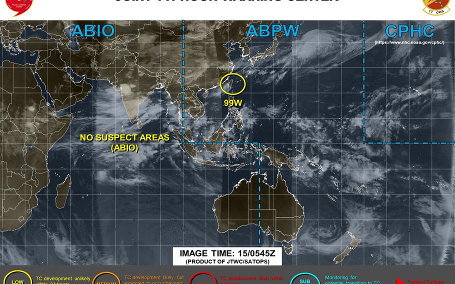
6:30 p.m. Wednesday, July 15, Japan time: 99W Invest has diminished into a mere low-pressure area over the last few hours. Joint Typhoon Warning Center reports it is no longer suspect for development into a tropical cyclone. This should be the final report on 99W.5:30 p.m. Wednesday, July 15, Japan time: 99W Invest continues to hang on, barely. Rain, showers, thunderstorms and gusty winds remain in Okinawa's forecast the rest of the week, but the chances of any sort of tropical cyclone developing are slim, at best. Joint Typhoon Warning Center downgraded 99W to a "low" area, meaning the chances of it developing into a tropical cyclone in the next 24 hours is low. U.S. bases on Okinawa remain in seasonal Tropical Cyclone Condition of Readiness 4. At 3 p.m., 99W, or what was left of it, was about 380 miles west-southwest of Kadena Air Base and had just about dissipated. It has also left the Philippines area of responsibility and is no longer subject to warnings from the national weather authority PAGASA. What Okinawa can expect the next few days is similar to what it's seen the last day or so. Kadena's extended weather forecast calls for 80-percent chance of rain, showers and thunderstorms into Saturday, with winds peaking at 20 mph with 32-mph gusts Thursday.5:30 p.m. Tuesday, July 14, Japan time: Will it become a tropical cyclone? Or will disturbance 99W Invest just fade away? Putting it as simply as possible: It's complicated. Joint Typhoon Warning Center reports that 99W currently sits in a marginal environment, buffeted by strong vertical wind shear and nestled between two land masses, southern Taiwan and Luzon island in the northern Philippines. Smallish, but land nonetheless. Neither of those factors are helpful to a tropical disturbance of any description. JTWC continues to label 99W as a "medium" area for development into a tropical cyclone in the next 24 hours. It could develop, or it could fade into your average, run-of-the-mill low-pressure area, as the Philippines' national weather authority PAGASA is suggesting. For folks on Okinawa, model-track guidance and the GFS and CMC forecast ensembles still show a turn in the island's general direction. While not expecting a tropical cyclone at the moment, we can still expect some rather nasty weather as the week progresses; Tuesday's scattered thundershowers offered some form of preview for that. At 3 p.m. Tuesday, 99W was 575 miles southwest of Kadena Air Base. U.S. bases on Okinawa remain in seasonal Tropical Cyclone Condition of Readiness 4 for now. Kadena's long-range forecast calls for 70- to 80[percent chance of rain, showers and scattered to widespread thunderstorms starting Wednesday morning and continuing the rest of the week. Expect winds to peak Thursday, southwesterly at 19 mph with gusts up to 31 mph, turning westerly and decreasing into Saturday. PAGASA continues to warn on what it labels Tropical Depression Carina, but says in its latest advisory that it could diminish into a low-pressure area by Tuesday night or Wednesday morning. All Tropical Cyclone Warning Signals have been lowered.6:30 p.m. Monday, July 13, Japan time: Rain, yes. Severe wind? Not so much, according to Joint Typhoon Warning Center and local weather forecasts regarding 99W Invest, which continues lurking southwest of Okinawa. At 6:15 p.m., 99W was 592 miles south-southwest of Kadena Air Base. U.S. bases on Okinawa remain in seasonal Tropical Cyclone Condition of Readiness 4. 99W is forecast to slowly move northwest toward the Batanes and Babuyan island groups in the northern Philippines, graze the east coast of Taiwan, then curve northeast toward Japan's southwestern islands, but as little more than a tropical depression, if that. JTWC labels 99W as a "medium" area for possible development into a tropical cyclone in the next 24 hours. Even so, JTWC indicates conditions for development are marginal, and that 99W will likely be absorbed into an approaching frontal boundary, known as a Meiyu, in the next day or so. That said, Okinawa can still expect quite a bit of rain from late Tuesday through the rest of the week.Kadena's long-range forecast calls for a 60-percent chance of rain, showers and scattered thunderstorms starting Tuesday evening, increasing to 80-percent Wednesday morning, with numberous and widespread thunderstorms as the week progresses. Stay tuned. The Philippines' national weather authority PAGASA has 99W labeled a tropical depression and has named it Carina. Tropical Cyclone Warning Signal 1 has been issued for the aforementioned island groups and portions of north and northeast Luzon.7 p.m. Sunday, July 12, Japan time: Weather forecasts, military and Japanese, agree that Okinawa should see quite a bit of rain by the middle of this week. But how much wind might the island get from 99W Invest, a disturbance still lurking well south-southwest of Okinawa? That remains to be seen. Joint Typhoon Warning Center still lists 99W's chances of developing into a tropical cyclone in the next 24 hours as low. U.S. bases on Okinawa remain in seasonal Tropical Cyclone Condition of Readiness 4. At 6:30 p.m., 99W was about 700 miles south-southwest of Kadena Air Base. Kadena's long-range forecast calls for wind gusts peaking at 26 mph Wednesday evening into Thursday morning, with a 60-percent chance of rain, showers and thunderstorms, increasing to 80 percent Thursday evening.Model guidance shows 99W slowly developing and curving northeast away from Taiwan and the Philippines' northernmost main island of Luzon toward Okinawa, passing west of the island between three to five days from now. The GFS and CMC forecast ensembles show similar. As to where it might head once past Okinawa, GFS ensemble sees 99W grazing the east coast of Japan's main islands, while CMC depicts a track right over them. But again, not as anything severe at the moment. It's a guessing game at this point. Still very early. Stay tuned.10 p.m. Saturday, July 11, Japan time: A new tropical disturbance, labeled 99W Invest, has formed northeast of Luzon, the Philippines’ northernmost island, but doesn’t appear to have much potential at the moment.
Still, this is weather, and the disturbance currently is in that area of the northwest Pacific where waters are warmest and the potential for tropical cyclones to develop is strong.
Model guidance currently shows 99W lingering southwest of Okinawa. The Global Forecast System, which tends to project development aggressively, and the Canadian Meteorological Centre each show a curve toward Okinawa, but nothing overly intense over the next few days.
Japanese weather forecast calls for rain, showers and possible thunderstorms Wednesday through Friday. The forecast at Windfinder.com, which is based on the GFS forecast model, calls for the same with increased winds, but nothing overly forceful.
