(U.S. Navy)
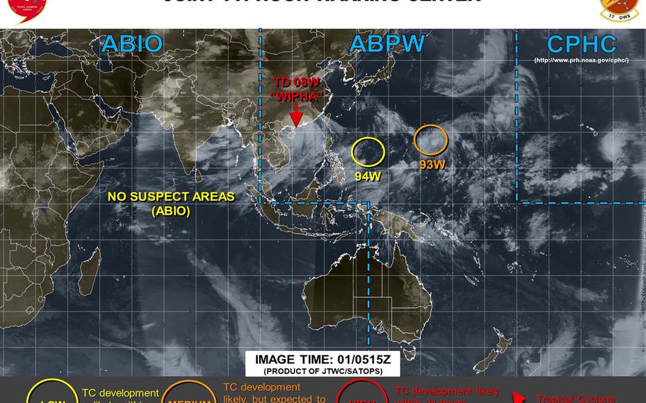
11 a.m. Friday, Aug. 2, Hong Kong time: All tropical cyclone warning signals for Hong Kong were canceled at 8:40 a.m. Nonetheless, Wipha has found new life as a newly upgraded tropical storm, now heading southwest toward Vietnam. This is the final report on Tropical Storm Wipha.4:45 a.m. Friday, Aug. 2, Hong Kong time: Wipha has been downgraded -- again -- to a tropical depression, has finished crossing the Leizhou Peninsula and is moving west over China's southeast coast en route to Vietnam, according to the Joint Typhoon Warning Center. At 2 a.m., Wipha was 228 miles east of Hanoi, moving west-northwest at 9 mph and had diminished slightly, to 35-mph sustained winds and 46-mph gusts. Standby Signal 1 remains raised for Hong Kong for now. If Wipha keeps moving as forecast, it's due to die out about 60 miles east of Hanoi at mid-afternoon Saturday.10:30 p.m. Thursday, Aug. 1, Hong Kong time: Tropical Storm Wipha has made landfall, is crossing the north portion of the Leizhou Peninsula and remains forecast to plow into northeastern Vietnam overnight Friday, according to the Joint Typhoon Warning Center. At 8 p.m., Wipha was 277 miles east of Hanoi, headed northwest at 12 mph and holding steady at 40-mph sustained winds and 52-mph gusts. Standby Signal 1 remains in force for Hong Kong; when local winds weaken further, the Hong Kong Observatory plans to cancel all warning signals. If Wipha continues on its present heading, it remains forecast to skim the coast of southeastern China, make secondary landfall northeast of Haiphong and dissipate as it approaches Hanoi late Saturday evening. JTWC reports.7:20 p.m. Thursday, Aug. 1, Hong Kong time: Standby Signal 1 has been raised for Hong Kong at 7:20 p.m., according to the Hong Kong Observatory. Tropical Storm Wipha continues moving northwest, away from Hong Kong, with winds diminishing as it goes.3:30 p.m. Thursday, Aug. 1, Vietnam time: Wipha can't seem to make up its mind. After a brief period as a tropical depression, Wipha was re-upgraded to a tropical storm and is preparing to cross the Leizhou Peninsula in southeastern China, according to the Joint Typhoon Warning Center. At 1 p.m., Wipha was 330 miles east of Hanoi, crawling northwest at 6 mph and had strengthened back to 40-mph sustained winds and 52-mph gusts. Strong Wind Signal 3 remains raised for Hong Kong and appears as if it will remain raised at least into Thursday evening. If Wipha continues on its present heading, it's forecast to plow across the northern portion of the Leizhou Peninsula, skim the southeastern coast of China and make landfall around mid-evening Friday northeast of Haiphong and die out as a tropical depression in Vietnam's interior.11:15 a.m. Thursday, Aug. 1, Hong Kong time: Wipha has been downgraded to a tropical depression and is forecast to skim the southeast coast of China and could die out entirely before reaching secondary landfall in Vietnam, according to the Joint Typhoon Warning Center. At 8 a.m., Wipha was 323 miles east of Hanoi, moving northwest at 8 mph and had diminished to 35-mph sustained winds and 46-mph gusts at center. Hong Kong remains in Strong Wind Signal 3 for now; that could change Thursday afternoon. If Wipha continues on its present course, it's due to follow the southeastern China coastline and could perish completely sometime Friday evening along the the northeastern Vietnam coast near Haiphong.Midnight Wednesday, July 31, Hong Kong time: Hong Kong reverted back to Strong Wind Signal 3 at 11:40 p.m. to replace Northeast Gale/Storm Signal 8, as Tropical Storm Wipha continues moving toward Leizhou Peninsula. At 8 p.m., Wipha was 235 miles southwest of Hong Kong, moving west-northwest at 11 mph and holding steady at 40-mph sustained winds and 52-mph gusts. If Wipha continues on its present course, it's forecast to make landfall over Leizhou Peninsula about 8 a.m. Thursday, start weakening as it turns west and make secondary landfall over Vietnam late Saturday evening as a tropical depression.5 p.m. Wednesday, July 31, Hong Kong time: Wipha has been upgraded to a tropical storm by the Joint Typhoon Warning Center. Northeast Gale/Storm Signal 8 should remain raised for the rest of the day in Hong Kong, according to the Hong Kong Observatory. At 2 p.m., Wipha was 238 miles south-southwest of Hong Kong, moving northwest at 12 mph and had strengthened to 40-mph sustained winds and 52-mph gusts. Closest point of approach to Hong Kong has come and gone and Wipha has reached its forecast wind peak, JTWC reports. If Wipha remains on its present heading, it's forecast to keep heading northwest, grazing the northeast corner of Hainan Island and crossing the southwestern edges of the Leizhou Peninsula through Thursday afternoon and make secondary landfall over Vietnam at mid-afternoon Friday. This should be far more of a rain than a wind event, HKO reports. Heavy showers and squalls are forecast and residents are asked to clear drains of leaves and rubbish, especially in low-lying areas, as soon as possible.2 p.m. Wednesday, July 31, Hong Kong time: Northeast Gale/Storm Signal 8 was raised for Hong Kong at 1:40 p.m. and is expected to remain in force for most of the rest of Wednesday, according to the Hong Kong Observatory. At 2 p.m., Tropical Depression Wipha was 211 miles south of Hong Kong and moving northwest at 9 mph. It's forecast to pass 186 miles southwest of Hong Kong early Wednesday evening. Hong Kong can expect 40-mph winds or greater from the northeast quarter. Wipha is forecast by the Joint Typhoon Warning Center to strengthen into a tropical storm later Wednesday. Stay tuned for changes.11 a.m. Wednesday, July 31, Hong Kong time: For the moment, Wipha remains a tropical depression, and it could be upgraded later Wednesday according to the Joint Typhoon Warning Center. And Hong Kong remains in Strong Wind Signal 3, and that could be upgraded to Gale or Storm Signal 8 later Wednesday, according to the Hong Kong Observatory. At 8 a.m., Wipha was 270 miles southwest of Hong Kong, crawling northwest at 7 mph and was holding steady at 35-mph sustained winds and 46-mph gusts. If Wipha remains on its current heading, it's forecast to intensify into a tropical storm by Wednesday evening but peak at 40-mph sustained winds and 52-mph gusts, and pass 252 miles southwest of Hong Kong at about 7 p.m. Wednesday. Tropical Depression 08W has been named Wipha by the Japan Meteorological Agency (second column, 12 down). Wipha is a Thai woman's name.4:45 a.m. Wednesday, July 31, Hong Kong time: The eighth numbered storm of the northwest Pacific's tropical cyclone season spawned overnight Tuesday and is forecast to pass well southwest of Hong Kong late Wednesday afternoon, according to the Joint Typhoon Warning Center. At 4:40 a.m., Tropical Depression 08W was 280 miles south-southwest of Hong Kong, moving west-northwest at 8 mph with 35-mph sustained winds and 46-mph gusts at center. If 08W remains on its present heading, it's due to curve northwest, peak at 40-mph sustained winds and 52-mph gusts at mid-afternoon and pass 252 miles southwest of Hong Kong at about 5 p.m. Wednesday.Strong Wind Signal 3 remains raised for Hong Kong. Unless 08W tracks further north, the chances of upgrading to Gale or Storm Wind Signal 8 are slim, according to the Hong Kong Observatory.Model track guidance and the GFS and CMC ensembles continue to show 08W tracking south-southwest of Hong Kong, with some solutions showing 08W curving back east toward Hainan island and others remaining over Vietnam. Stay tuned for any changes.10:45 p.m. Tuesday, July 30, Hong Kong time: Strong Wind Signal 3 was raised for Hong Kong at about 9:20 p.m., meaning winds between 25 and 40 mph are expected from 92W Invest overnight into Wednesday morning for the city, according to the Hong Kong Observatory. At 10 p.m. 92W was about 300 miles south of Hong Kong and was moving west at about 7 1/2 mph, headed toward western Guangdong. HKO reports 92W is forecast to continue westward; thus, unless it takes a more northerly track, chances are the wind signal might not be upgraded. Stay tuned.4:30 p.m. Tuesday, July 30, Hong Kong time: A tropical cyclone formation alert has been issued on a disturbance labeled 92W Invest, which at 4:20 p.m. was 278 miles south of Hong Kong and headed northwest.
Standby Signal 1 has been raised for Hong Kong and Strong Wind Signal 3 may be raised by Wednesday morning, though model track guidance and the GFS and CMC model ensembles indicate the system should pass southwest of Hong Kong.
