(U.S. Navy)
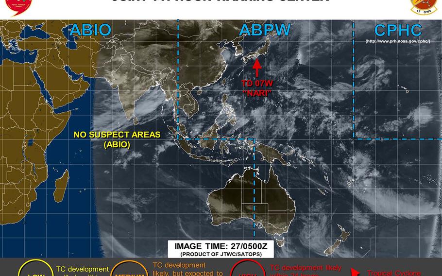
12:15 p.m. Saturday, July 27, Japan time: Nari made landfall Saturday morning near Wakayama in central Honshu, has been downgraded to a tropical depression and is forecast to pass further northwest of the Kanto Plain than previously reported. At 9 a.m., Nari was 185 miles west of Yokosuka Naval Base, tracking north-northeast at 18 mph and had diminished to 29-mph sustained winds and 40-mph gusts. Nari is forecast to curve northeast, continue weakening and passing 70 miles northwest of Yokota Air Base at 9 p.m. Saturday. Yokota is expecting between 2 to 4 inches of rain associated with Nari, according to the base's official Facebook page. A thunderstorm watch will be in effect from 3 a.m. to noon Sunday and small-craft warning is in effect until 9 a.m. Sunday, according to Yokosuka's extended weather forecast. Expect south to southwesterly winds between 23- to 28-mph sustained and 40-mph gusts overnight Saturday into Sunday. Storm Tracker will keep watch for signs of regeneration. Barring that, this should be the final report on Nari. 12:15 a.m. Saturday, July 27, Japan time: Looks as if Nari might not have much life left as a tropical storm, and its latest forecast track takes it slightly further inland and north of U.S. bases in the Kanto Plain. At 9 p.m., Nari was 310 miles southwest of Yokosuka Naval Base, moving north-northwest at 14 mph and holding steady at 40-mph sustained winds and 52-mph gusts. That might not last much longer; Nari is forecast by Joint Typhoon Warning Center to start weakening as it approaches the coast of southwest Mie Prefecture. If Nari continues on its present course, it's forecast to make landfall at about 9 a.m. near Shingu in southwest Mie Prefecture as a tropical depression. It's then due to cross Ise Bay and over Nagoya, through the Japan Alps in central Honshu and 36 miles northwest of Yokota Air Base early Sunday morning as a tropical depression, 35-mph sustained winds and 46-mph gusts as it rolls through.6 p.m. Friday, July 26, Japan time: Tropical Storm Nari has altered course slightly, tracking almost due northwest, but is still forecast to curve northeast overnight into Saturday and pass just north of U.S. bases in the Kanto Plain early Sunday morning. At 3 p.m., Nari was 360 miles south-southwest of Yokosuka Naval Base and moving northwest at 15 mph, holding steady at 40-mph sustained winds and 52-mph gusts. If Nari continues on its present course, it's due to start curving northeast overnight Friday into Saturday, skirting the Honshu coast along Kumano and Owase in southwestern Mie Prefecture between Osaka and Nagoya just past sunrise Saturday. Nari should then gradually weaken as it heads inland, passing over Nagoya at mid-afternoon, then head through the Japan Alps, passing 23 miles northwest of Yokota Air Base at 3 a.m. Sunday, with 29-mph sustained winds and 40-mph gusts at center as it quickly moves through. Model track guidance and forecast ensembles remain in tight agreement with JTWC's forecast track. Marine Corps Air Station Iwakuni remains well out of harm's way. No accelerated Tropical Cyclone Condition of Readiness has been issued yet.Yokota Air Base's official Facebook page says the base can expect 25-mph gusts along with between 2 to 4 inches of rain through Sunday. Might not be good news for folks living on the east side, which is rather low-lying and subject to flooding. Take special care to avoid such areas. For Yokosuka, a thunderstorm watch is in effect for midnight to 6 a.m. Saturday and a small-craft warning from noon Saturday to 9 a.m. Sunday. Yokosuka's extended forecast still calls for southerly wind picking up Friday and peaking Saturday evening into Sunday at 23- to 28-mph sustained and 40-mph gusts, with isolated showers and thunderstorms.12:30 p.m. Friday, July 26, Japan time: It now appears that Tropical Storm Nari might pass north of U.S. bases in the Kanto Plain as it makes landfall over central Japan and trudges northeast through Honshu's central mountains. At 9 a.m., Nari was 415 miles south-southwest of Yokosuka Naval Base, moving north-northwest at 14 mph and holding steady at 40-mph sustained winds and 52-mph gusts. If Nari remains on its present heading, it should maintain that intensity until reaching land at mid-day Saturday, just southwest of Nagoya. Nari is then forecast to curve northeast, gradually weakening as it passes over the Japan Alps, passing 30 miles northwest of Yokota Air Base at about 4 a.m. Sunday as a tropical depression, 29-mph sustained winds and 40-mph gusts. A thunderstorm watch will be in effect at Yokosuka from midnight to 6 a.m. Saturday. Yokosuka's extended weather forecast calls for southerly winds picking up Friday, peaking early Saturday morning in thunderstorms and again in the afternoon into Sunday morning, 23- to 28-mph sustained winds and 40-mph gusts, shifting southwesterly and diminishing Sunday afternoon. No accelerated tropical cyclone conditions of readiness have been issued at this point. Stay tuned.11:45 p.m. Thursday, July 25, Japan time: 07W wasted little time strengthening into a tropical storm, and the Joint Typhoon Warning Center's latest forecast track puts Yokota in the crosshairs for a mid-morning Sunday rendezvous ... but as not much more than a tropical depression. At 9 p.m., 07W, still not named, was 555 miles south-southwest of Yokosuka Naval Base and had found its forward speed again, moving north at 12 mph with 40-mph sustained winds and 52-mph gusts. If 07W maintains its present heading, it's forecast to head slightly north-northwest, then curve sharply right, weaken to a tropical depression and make landfall just south of Nagoya late Saturday evening, then pass directly over Yokota at 8 a.m. Sunday.Model track guidance and the GFS and CMC forecast ensembles pretty much mirror the JTWC forecast track.Yokosuka's extended weather forecast calls for southerly winds to start picking up Friday evening and peaking at 20- to 25-mph sustained winds and 35-mph gusts, with isolated showers and thunderstorms through Sunday. 6:30 p.m. Thursday, July 25, Japan time: Looks as if Tropical Depression 07W might have a brief life as a tropical storm in the next day or so. But as it tracks toward Japan's main island of Honshu, it's forecast to taper back down to a tropical depression as it curves northeast toward Tokyo. At 3 p.m., as yet unnamed 07W was 620 miles south-southwest of Yokosuka Naval Base, had screeched almost to a halt, crawling north at 4 mph and had slightly strengthened to 35-mph sustained winds and 46-mph gusts. If it remains on its present course, 07W is forecast to north-northwest toward Japan's Kansai region, then curve sharply right, well out of range of Marine Corps Air Station Iwakuni, then charge northeast toward a rendezvou Sunday morning with U.S. bases in Tokyo. 07W is forecast to peak at 40-mph sustained winds and 52-mph gusts overnight Thursday into Friday, then weaken as it approaches Honshu, passing 227 miles east of Iwakuni at 10 a.m. Saturday. 07W is due to make a near-direct hit on Naval Air Facility Atsugi and Camp Zama at 7 a.m. Sunday, with 35-mph sustained winds and 46-mph gusts. No warnings or accelerated Tropical Cyclone Conditions of Readiness have been issued at this point. Long-range forecast for Yokosuka remains unchanged. Storm Tracker has the watch. If 07W becomes a named storm, it would be called Nari (second column, 11th down), Korean for lily.12:45 p.m. Thursday, July 25, Japan time: Kanto Plain bases can expect a gusty, rainy visitor this weekend, though there's no danger at this point of destructive winds, according to the Joint Typhoon Warning Center's first warnining on Tropical Depression 07W. At 9 a.m., as yet unnamed 07W was 633 miles south of Yokosuka Naval Base, headed north at 13 mph with 29-mph sustained winds and 40-mph gusts. If 07W continues on its present heading, 07W is forecast to peak at 35-mph sustained winds and 46-mph gusts, remaining a tropical depression throughout its journey north. It's due to make landfall in the Nagoya area southwest of Tokyo at mid-afternoon Saturday. It's then forecast to cruise northeast through the Kanto Plain, making a near-direct hit on Yokota and passing 17 miles northwest of Naval Air Facility Atsugi and Camp Zama and 36 miles northwest of Yokosuka at about 8 a.m. Sunday.No warnings or tropical cyclone conditions of readiness are in effect at this point.Yokosuka's extended weather forecast calls for southerly winds to pick up Friday evening, peaking at between 22 and 28 mph with 35-mph gusts Saturday afternoon, with isolated showers and thunderstorms Saturday and Sunday. Doesn't look like it might amount to much at this point -- it could strengthen to a tropical storm at some point before landfall -- but keep tuned to Storm Tracker, AFN radio and to your base official television channels and Facebook pages ... just in case.6:30 p.m. Wednesday, July 24, Japan time: A tropical cyclone formation alert has been issued on a developing disturbance about 750 miles south-southwest of Yokosuka Naval Base.
Joint Typhoon Warning Center reports the system is forecast to consolidate and head northeast toward the Tokyo area and developing into at least a tropical depression, perhaps a tropical storm, in the coming days. U.S. bases on Okinawa, Marine Corps Air Station Iwakuni and Fleet Activities Sasebo are well out of harm’s way.
Model track guidance and the GFS and CMC ensembles are in good agreement on a track north toward the Tokyo area, then northeast over or near the east coast of Japan’s main island of Honshu. Storm Tracker is keeping watch.
