()
5 p.m. Monday, July 1, Philippines time: Egay has been downgraded to a low-pressure area by the Philippines' national weather authority PAGASA. Tropical Cyclone Warning Signal 1 for Babuyan and Batanes island groups has been lifted. Barring regeneration, this is Storm Tracker's last report on Egay.2 p.m. Monday, July 1, Philippines time: Tropical Depression Egay, or the remnants of TD 04W, has slowed to a crawl in its journey northwest. Tropical Cyclone Warning Signal 1 has been raised for the northern Philippines' Babuyan and Batanes island groups by the national weather authority PAGASA. At 2 p.m., Egay was 110 miles east of Calayan in northeast Cagayan province and sitting quasi-stationary.11 p.m. Sunday, June 30, Philippines time: Tropical Depression 04W continues to weaken and unravel, to the point where the Joint Typhoon Warning Center has issued its final warning on the system.
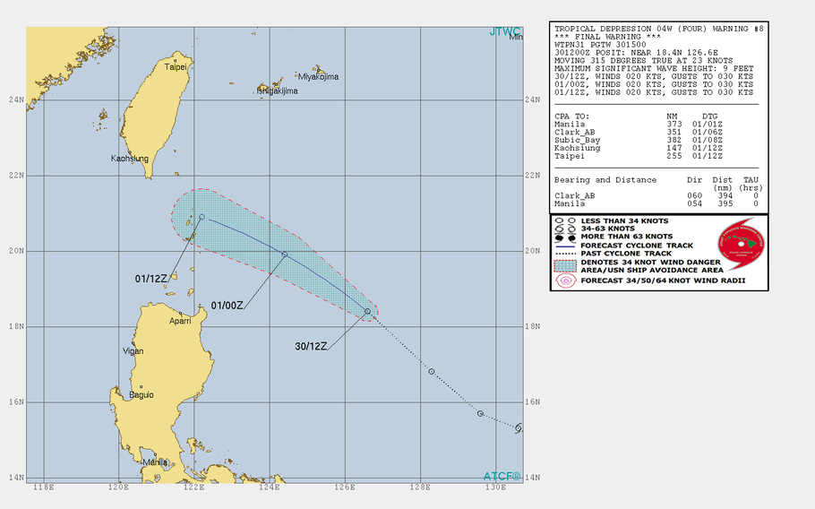
At 10:30 p.m., TD 04W was 455 miles northeast of Metro Manila and 555 miles south of Kadena Air Base, Okinawa, and was tracking rapidly northwest at 26 mph. It has just 23-mph sustained winds and 35-mph gusts at center – which really isn’t much of a center any more, “ragged, exposed and ill-defined circulation,” JTWC termed it in its final update on the system.
The Philippines’ national weather authority PAGASA continues to carry 04W as Tropical Depression Egay and has raised Tropical Cyclone Warning Signal 1 for only the Batanes group of islands, the country’s northernmost land masses.
JTWC and Storm Tracker will keep an eye on 04W for any signs of regeneration.
5:15 p.m. Sunday, June 30, Taiwan time:04W has been downgraded to a tropical depression by the Joint Typhoon Warning Center, and its latest forecast track calls for 04W to gradually diminish as it traverses the Luzon Strait into southeastern China, if it survives that long.
At 4:30 p.m., TD 04W was 500 miles east-northeast of Metro Manila and 680 miles south of Kadena Air Base, Okinawa, headed northwest at 16 mph and had weakened to 35-mph sustained winds and 46-mph gusts.
Model track guidance remains mixed. Most solutions favor a track between Luzon and Taiwan, with landfall over southeastern China possible around mid-day Wednesday. However, JTWC also says TD 04W could dissipate even before reaching land.
Okinawa continues to remain out of TD 04W’s forecast range and U.S. bases on island remain in seasonal Tropical Cyclone Condition of Readiness 4.
5 a.m. Sunday, June 30, Taiwan time: Looks as though Tropical Storm 04W might pass further south, near Taiwan's southern edges, than previously forecast. Okinawa continues to remain out of harm's way for the moment. At 4:30 a.m., TS 04W was 780 miles south-southeast of Kadena Air Base, Okinawa, and 650 miles east of Metro Manila, moving northwest at 7 mph and had weakened slightly, to 40-mph sustained winds and 52-mph gusts, according to the Joint Typhoon Warning Center. If TS 04W remains on its current path, it's forecast to peak at 63-mph sustained winds and 81-mph gusts at about 2 a.m. Tuesday as it approaches southern tip of Taiwan. It's forecast to pass 23 miles south-southwest of Kaohsiung at 1 p.m. Tuesday, weakening as it heads northwest through the Formosa Strait into southeastern China; landfall should occur early Wednesday morning. U.S. bases on island remain in seasonal Tropical Cyclone Condition of Readiness 4. The base's extended weather forecast calls for nothing unusual the next few days. TS 04W has entered the Philippines area of responsibility and has been named Tropical Depression Egay by the national weather authority PAGASA. No wind warning signals have been raised at this point. Egay's forecast track takes it near the northern Babuyan and Batanes island groups.11 p.m. Saturday, June 29, Taiwan time: Little change regarding Tropical Storm 04W. At 10:30 p.m., it was 675 miles east of Metro Manila and 830 miles south-southeast of Kadena Air Base, Okinawa, headed west-northwest at 8 mph and had intensified slightly, to 46-mph sustained winds and 58-mph gusts. TS 04W is forecast to rumble ashore about 15 miles northeast of Kaohsiung in southern Taiwan at 1 a.m. Wednesday, after peaking at 63-mph sustained winds and 81-mph gusts a few hours earlier. TS 04W should then cross south-central Taiwan, then the Formosa Strait into southeastern China, about 210 miles east-northeast of Hong Kong at about 1 a.m. Thursday. U.S. bases on Okinawa remain in seasonal Tropical Cyclone Condition of Readiness 4. No wind warning signals have been raised for the Philippines, Taiwan or Hong Kong for now; that could change as early as Sunday morning.Model track guidance remains mixed. GFS ensemble also remains divided, with some solutions favoring Taiwan and others southern China and northeastern Vietnam. CMC ensemble shows an even more vast spread, as far northeast as Japan and west as southeastern China.6:45 p.m. Saturday, June 29, Japan time: 04W wasted little time strengthening into a tropical storm, halfway through its first day as a tropical cyclone. But little has changed otherwise, with 04W still on course to plow over Taiwan by the middle of next week. Okinawa remains out of danger for now. At 6:30 p.m., TS 04W was 860 miles south-southeast of Kadena Air Base, heading west-northwest at 7 mph and having intensified to 40-mph sustained winds and 52-mph gusts at center, according to the Joint Typhoon Warning Center. JTWC forecasts TS 04W to keep heading northwest, making landfall over southeastern Taiwan by mid-evening Tuesday, peaking at 63-mph sustained winds and 81-mph gusts, then crossing the island into the Formosa Strait and making secondary landfall over southeastern China by mid-evening Wednesday.Model track guidance remains a mixed bag. The GFS model ensemble is somewhat divided, with some solutions depicting a track over Taiwan and curving over China's southeast coast toward Japan. The CMC ensemble favors a best track toward northern Taiwan, with some solutions pointing toward central Taiwan and others curving around Okinawa toward southwestern Japan. U.S. bases on Okinawa remain in seasonal Tropical Cyclone Condition of Readiness 4. More to come. PST has the watch.11:45 a.m. Saturday, June 29, Taiwan time: Tropical Depression 04W remains on course to primarily affect Taiwan, with some solutions depicting a path south of the island and other solutions favoring a track toward the island's center. Okinawa remains out of danger for now. At 8 a.m., TD 04W was 750 miles east of Manila, headed west-northwest at 6 mph and had strengthened to 35-mph sustained winds and 46-mph gusts at center. According to the Joint Typhoon Warning Center, if TD 04W remains on its present path, it's forecast to peak at 58-mph sustained winds and 74-mph gusts between 8 a.m. Tuesday and 8 a.m. TD 04W is forecast to make landfall around mid-morning Wednesday over south-central Taiwan, cross the island southeast to northwest, pass through the Formosa Strait and make secondary landfall over southeastern China at mid-morning Thursday. The GFS model ensemble depicts a track south of Taiwan and affecting the Philippines' Babuyan and Batanes island groups. The CMC ensemble favors the track further north over south-central Taiwan, with only a couple of solutions curving it northeast toward Japan. TD 04W is forecast to pass well away from Okinawa; JTWC projects 450 miles southwest of Kadena Air Base at mid-evening Tuesday. U.S. bases on Okinawa remain in seasonal Tropical Cyclone Condition of Readiness 4. On another note, Japan Meteorological Agency on Saturday morning declared an end to the annual rainy season for Okinawa.5 a.m. Saturday, June 29, Philippines time: The fourth numbered storm of the northwest Pacific's tropical cyclone season has formed well east of Manila and south of Okinawa, with Taiwan currently in its crosshairs. At 4:45 a.m., Tropical Depression 04W was 920 miles south-southeast of Kadena Air Base and 782 miles east of Metro Manila, moving northwest at 9 mph with 30-mph sustained winds and 40-mph gusts at center. If 04W continues on its present course, it's forecast to make landfall on Taiwan's east-central coast at about 2 a.m. Wednesday at just below Category 1-equivalent strength, 69-mph sustained winds and 86-mph gusts. For the moment, Okinawa appears out of the line of fire; 04W is due to pass 440 miles southwest of Kadena at 11 p.m. Tuesday. U.S. bases on Okinawa remain in seasonal Tropical Cyclone Condition of Readiness 4. So, too, does the Philippines appear out of range for the most part; 04W is forecast to pass 460 miles northeast of Metro Manila at 7 p.m. Monday. The Babuyan and Batanes island groups north of Luzon might feel some of 04W's effects after that.Model track guidance also points to Taiwan, as do the GFS and CMC model ensembles, with only a couple of solutions pointing to Okinawa at the moment. PST has the watch.3:30 p.m. Friday, June 28, Japan time: A tropical cyclone formation alert has been issued for 95W Invest by the Joint Typhoon Warning Center. It's still anybody's guess which way 95W might wend. Model track guidance has been all over the lot the last day or so, and currently points to Taiwan as a possible destination. The GFS model ensemble shows a vast spread among solutions, stretching from Ishigaki in southwestern Japan to northern Luzon. The CMC ensemble shows a similar spread, stretching from Amami Oshima in southwestern Japan to the Philippines' northern Babuyan and Batanes island groups. Most likely, 95W could develop into a tropical depression in the next day or so. Should it become a named system, it would be called Mun, which is Yapese for the month of June. Might be just in time for the end of the month.4 a.m. Friday, June 28, Japan time: So, just which way might 95W Invest head, if in fact it does become a tropical cyclone in the coming days? Model guidance at this point is all over the lot: -- The GFS model ensembles indicate a west-northwest track toward southern Taiwan, the Batanes and Babuyan island groups and northern Luzon in the Philippines. -- The CMC ensembles favor a more northwesterly approach toward Taiwan, with solutions spread over a rather vast area between Okinawa and the Formosa Strait, as far west as Hong Kong. That's why it's way too early to say definitively which way 95W might go. Even once it becomes a tropical cyclone, if it does, it might take a day or three for the system to consolidate and for model groups to tighten and settle on one firm destination. Patience and preparation are key. Even if 95W fades away, there'll always be more tropical cyclones on the way. It is that time of year. Newcomers, especially, give the story in this link a look; plenty of tips and hints on how to prepare for the worst. U.S. bases on Okinawa remain in seasonal Tropical Cyclone Condition of Readiness 4. PST has the watch.4:15 p.m. Thursday, June 27, Japan time: Just as 94W Invest is disappearing northeast of Okinawa, we get another disturbance on the grid, 95W Invest, forming up well south of Okinawa and forecast to head northwest in the general direction of Taiwan over the next week.
At 4 p.m., 95W was 616 miles west-southwest of Guam. Joint Typhoon Warning Center reports 95W is struggling to organize, but that conditions are favorable for development.
Initial model track guidance and the GFS and CMC model ensembles have 95W tracking toward Taiwan, with some models taking it toward the Philippines and others curving around Okinawa toward southwestern Japan.
How strong it will become, and whether it affects Okinawa, Korea or Japan, is way too soon to say. Stay tuned. PST has the watch.
