()
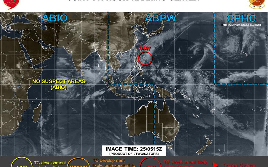
5:30 a.m. Thursday, June 27, Japan time: Thursday dawned peacefully on Okinawa, as 94W Invest passed just east of the island overnight and is headed north toward southwestern Japan. At 3 a.m., 94W was roughly 95 miles east of Kadena Air Base moving north at 12 mph. Most of the heavy stuff, gusty winds and heavy showers, was displaced well east of Okinawa over the Daito Islands. It's a sub-tropical system; it should not become a tropical depression or worse. As 94W moves north, it's pushing the rainy-season front north as well, Thus, Sasebo Naval Base and Marine Corps Air Station Iwakuni can expect quite a bit of rain, with the former bracing for some pretty heavy winds as well. A blustery, showery Thursday for those folks. As for Okinawa, it might see some patches of sunlight in the morning until mid-day, when the local forecast calls for one last blast of showers in the afternoon and again late in the evening. U.S. bases remain in seasonal Tropical Cyclone Condition of Readiness 4. And as for what might be down the road, there is another invest out there, 95W, but it's still in the very early formative stages. Whether it becomes something significant, whether it heads toward the Philippines or Okinawa, is still very much up in the air. PST has the watch.5:45 p.m. Wednesday, June 26, Japan time: Looks like most of the really heavy rain for Okinawa associated with 94W Invest may be ending, with a few pockets of showers left to the southeast which might or might not affect the island. At 5:30 p.m., 94W was 320 miles south of Kadena Air Base, moving north-northeast at 12 mph. U.S. bases on Okinawa remain in seasonal Tropical Cyclone Condition of Readiness 4. Still a pretty good idea to be on guard for flooding especially in low-lying areas as it gets dark and harder to see.Local forecast calls for more showers, heavy at times, picking up around 6-ish and continuing until mid-evening, perhaps a bit later, with southeasterly winds gusting up to 35 mph, shifting southwesterly overnight into Thursday. As 94W continues north-northeast, we might also see the rainy season front shift north toward southwestern Japan; the local forecast for Kyushu and Shikoku islands call for rain to start picking up as early as Wednesday evening as 94W races past, later this week into the weekend. Rainy season on Okinawa began on May 16; looks like the Japanese weather authorities may declare an end to it Friday or Saturday. Just for 411, the latest end to a rainy season on Okinawa was July 9, 1976. And this would also be the latest start to a rainy season in southwestern Japan since 1951, authorities said.11:30 a.m. Wednesday, June 26, Japan time: Rain, rain, go away, etc. While 94W Invest has not morphed into anything tropical in nature, one thing Okinawa is getting in plain abundance is rain associated with the system, which is forecast to pass southeast of Okinawa on Wednesday.Local forecast calls for heavy rain continuing through mid-evening Wednesday with strong southeasterly winds, shifting to southwesterly late Wednesday evening into Thursday. Kadena's 18th Wing Weather Flight forecast calls for much the same. From midight Tuesday through 11:15 a.m. Wednesday, the island's prefectural capital of Naha has had more than 4 inches of rain, as has Kadena Air Base, "with more rain to come," a Weather Flight official said. Most of Okinawa's main island, which is getting the brunt of 94W, is under a heavy rain and flood warning. Naha and Okinawa City, near Kadena, are under a landslide warning as well. Nishihara, Urasoe (near Camp Kinser) and Chatan (near Camp Foster) have already suffered some landslides. Tomigusuku, south of Naha; Urasoe, and Uruma on the island's east coast near Camp Courtney are at Level 3 warnings for elderly and handicapped people to prepare to evacuate to higher ground. Most likely, many people's portable phones are making those ring tones with warning messages in Japanese. Those are all related to the current storm, and more can be expected. One major key to remaining safe: Avoid low-lying areas and especially do not try to drive through flooded areas. Cars and floods do not get along well. The bright side to this, if there is such a thing, is the island's reservoir levels remain at 100 percent and should stay that way for several days thanks to run-off from all this rain.6:45 p.m. Tuesday, June 25, Japan time: 94W Invest remains in tropical cyclone formation alert status, tracking north toward Okinawa. All indications are that Wednesday is going to be a rainy, gusty day — though nothing tropical in nature is expected. At 6:30 p.m., 94W was 533 miles south-southwest of Kadena, tracking north and expected to pass Okinawa early Wednesday into mid-day. The local forecast calls for rain to pick up on Okinawa late evening Tuesday, with rain, showers and isolated thunderstorms — heavy at times — throughout the day Wednesday with gusty southeasterly winds. U.S. bases on Okinawa remain in seasonal Tropical Cyclone Condition of Readiness 4. Destructive winds of 58 mph or greater are not forecast at this time, officials at Kadena Air Base's 18th Wing Weather Flight said. Meanwhile, the Philippines' national weather authority PAGASA has issued its first severe weather bulletin on 94W Invest, which it has named Dodong. At 4 p.m., Dodong was 380 miles east of Calayan in Cagayan province of Luzon island.2 p.m. Tuesday, June 25, Japan time: Looks like 94W Invest has finally made up its mind what it wants to do. Thus, Okinawa can expect more of what it's seen the last few weeks, more heavy rain and gusty winds at least through Thursday. The Joint Typhoon Warning Center issued a tropical cyclone formation alert on 94W at 11 a.m. local time Tuesday.Model track guidance, the GFS and CMC model ensembles agree on a forecast track north for 94W toward Okinawa over the next day or so, then curving northeast as it encounters southwestern Japan. 94W might not amount to much other than what's called a sub-tropical low. It would bring Okinawa and southwestern Japan pretty much what the former has encountered during the rainy season, heavy rain and gusty winds. The local forecast for Okinawa calls for rain to pick up starting early Tuesday evening and lasting through early Thursday morning, very heavy at times, with southeasterly winds through early Thursday morning, turning southwesterly by mid-morning. Kadena Air Base's 18th Wing Weather Flight extended forecast calls for much of the same, between 60- to 80-percent chance of rain, showers and isolated thunderstorms with southeasterly winds gusting up to 33 mph Wednesday evening and Thursday morning. U.S. bases on Okinawa remain in seasonal Tropical Cyclone Condition of Readiness 4. Destructive winds of 58 mph or greater are not anticipated for the moment, 18th Wing Weather Flight officials said. At 10 a.m. Philippines time, 94W was 280 miles east of Aparri in Cagayan province in northeastern Luzon. It's not expected to affect the Philippines, though the southwestern monsoon, or Habagat, is expected to bring showers and thunderstorms to Metro Manila, according to the national weather authority PAGASA. No wind warning signals have been issued at this time.3:30 p.m. Monday, June 24, Japan time: Here we go again. 94W Invest has been upgraded again by the Joint Typhoon Warning Center to a medium area, development likely but not within the next 24 hours. JTWC projects 94W to continue briefly northwest, then curve northeast and possibly intensifying into a sub-tropical low. Sort of like the weather Okinawa experienced last week, showers, heavy at times, with gusty winds.Model track guidance and the GFS and CMC model ensembles all concur with JTWC's forecast. The Philippines' national weather authority PAGASA reports that 94W was 470 miles east of Casiguran in northeast Aurora, along Luzon's east coast and could develop into a tropical depression in the next 48 hours. If that happens while it's in the Philippines' area of responsibility, 94W would be named Dodong. But it's still a guessing game at this point. U.S. bases on Okinawa remain in seasonal Tropical Cyclone Condition of Readiness 4. Kadena Air Base's long-range weather forecast continues to call for showers and isolated thunderstorms, heavy at times, with gusts as high as 28 mph. PST has the watch.4 p.m. Sunday, June 23, Japan time: 94W Invest has been downgraded by the Joint Typhoon Warning Center to a low area, with development into a tropical cyclone unlikely in the next 24 hours. Models generally agree on 94W heading northwest with no intensification. Barring unforeseen strengthening, this is PST's final report on 94W.6:30 p.m. Saturday, June 22, Japan time: About all the models agree on is that 94W Invest should keep moving slowly, gradually northwest. But there remain many questions about how strong 94W will get, how much it will develop. Little can be had from GFS and CMC model ensembles or model track guidance at this point. U.S. bases on Okinawa remain in seasonal Tropical Cyclone Condition of Readiness 4. PST still has the watch.4 p.m. Friday, June 21, Japan time: Model guidance and ensembles remain divided on just what 94W Invest will do in the coming days. The only certainty remains uncertainty.Joint Typhoon Warning Center's latest update continues to depict 94W as a "medium" area for possible development but not within the next 24 hours. The GFS ensemble appears more muddled than ever, and its corresponding Web product Windfinder.com now no longer shows a possible tropical event next weekend on Okinawa. The CMC ensemble shows widely-scattered solutions, but with a best track over or near Okinawa six days out. U.S. bases on Okinawa remain in seasonal Tropical Cyclone Condition of Readiness 4. And PST still has the watch.7 a.m. Friday, June 21, Japan time: It remains too early to tell at this point what 94W Invest might become, and when, as it continues its slow journey north toward toward Yap. 94W continues to be depicted as a "medium" area by the Joint Typhoon Warning Center, formation of a tropical cyclone likely but not within the next 24 hours. The National Weather Service on Guam continues to report 94W as a weak circulation, which could bring heavy showers and gusty winds to Yap and Palau over the next few days. Where it goes and what it becomes after that ... the only thing certain remains uncertainty.Model track guidance remains muddled at this point. The GFS forecast ensemble no longer shows a best track headed in Okinawa's general direction; the CMC ensemble continues showing a best track passing east of Okinawa about five to six days from now. U.S. bases on Okinawa remain in seasonal Tropical Cyclone Condition of Readiness 4. Kadena's long-range weather forecast calls for showers and winds, but nothing tropical. Windfinder.com suggests a possible spike in winds over June 28-29. PST has the watch.11:30 p.m. Thursday, June 20, Japan time: 94W Invest has slowly begun trekking north and northwest, and model ensembles indicate it might pass just east of Okinawa about six days out. The question remains, if it does pass Okinawa, what will 94W become? And if it does become tropical in nature, how strong or weak might it be? The only thing certain at this point ... is uncertainty. 94W hasn't even become a tropical depression yet. A wait-and-see game at this point.Joint Typhoon Warning Center's latest update reports slow development possible over the next few days as it gradually heads northwest. But while warm sea-surface temperatures are conducive for development, the upper- and mid-level environments aren't favorable; wind shear and mid-level dry air, which tropical disturbances don't like. Still, the GFS and CMC model ensembles each show a best track just east of Okinawa by the middle of next week, with central air pressure low enough to at least make for gusty, showery days as 94W passes by. Windfinder.com does indicate a possible spike in wind speeds by the middle of next week at Kadena and Torii Station. And it might even make for a miserable couple of days for southwestern Japan, assuming it remains tropical in naturethat far ahead in the game. PST has the watch.4:30 p.m. Thursday, June 20, Japan time: As stated earlier in this space, you never know what a disturbance might do. A day ago, model guidance suggested 94W Invest, still lurking southeast of Palau, had little potential for development. Not so any more.Joint Typhoon Warning Center's latest report indicates 94W could develop slowly as it continues on a gradual northwest track, possibly becoming a tropical depression within the next four days. 94W has been upgraded by JTWC to a "medium" area, development of a tropical cyclone likely, but beyond the next 24 hours or so. The current CMC model ensemble does provide a best track taking 94W just east of Okinawa six days out. But as what? Hard to say at this point. U.S. bases on Okinawa and Guam remain in seasonal Tropical Cyclone Condition of Readiness 4. PST continues to keep a sharp lookout.6:30 p.m. Wednesday, June 19, Japan time: 94W Invest remains southeast of Palau, but the latest from the Joint Typhoon Warning Center says model guidance agrees on a northwest track with little to no intensification. JTWC continues to report the chances of 94W Invest developing into a tropical cyclone within the next 24 hours are low. U.S. bases on Okinawa remain in seasonal Tropical Cyclone Condition of Readiness 4. PST will continue to monitor.8:30 p.m. Tuesday, June 18, Japan time: For the moment, it doesn’t appear as if a new tropical disturbance, developing about 320 miles east-southeast of Palau and 1,600 miles south-southeast of Okinawa, will develop into anything significant, forecasters at the National Weather Service on Guam said Tuesday.
94W Invest has been on the grid for the last couple of days, sitting over warm waters just north of Yap and east of Mindanao in the southern Philippines and crawling slowly north.
NWS officials and Joint Typhoon Warning Center bulletins say that 94W is a broad system moving very slowly northward and not forecast to develop into anything significant at the moment.
Model track guidance is vastly spread, with no “best tracks” available for either the GFS and CMC model ensembles.
One forecaster at NWS on Guam said by Wednesday evening, most models have 94W washing out as it passes several hundred miles east parallel to the northern edges of Luzon Island in the northern Philippines.
Still, this is weather we’re talking. A day ago, the GFS best track had 94W developing into a semi-sort of significant tropical cyclone passing just east of Okinawa. Now, this. Things could change again, and rapidly. These are unpredictable buggers; they can turn on a dime and give back nine cents’ change.
Pacific Storm Tracker will keep an eye on the disturbance.
