(U.S. Navy)
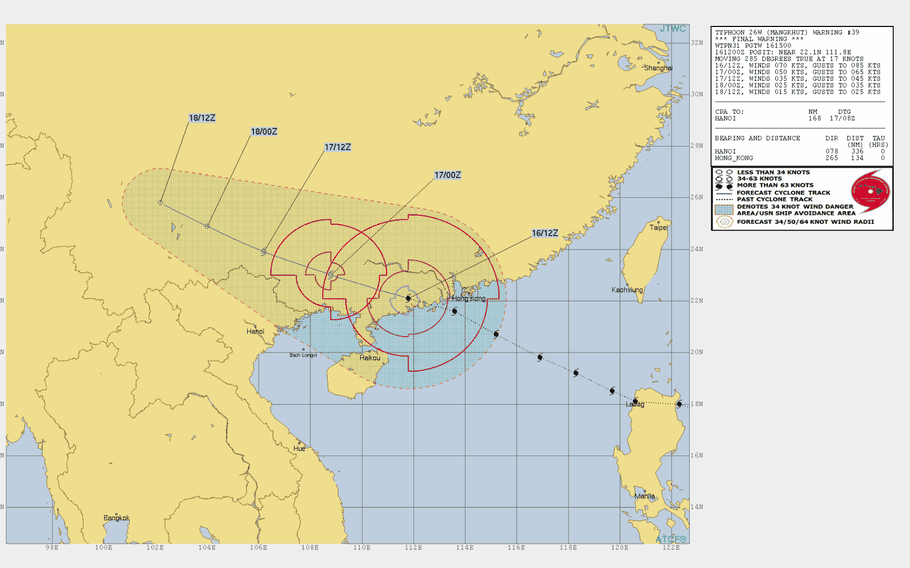
7:10 p.m. Monday, Sept. 17, Hong Kong time: All tropical cyclone warning signals for Hong Kong were canceled at 7:10 p.m. by the Hong Kong Observatory. This concludes coverage of Typhoon Mangkhut.11 p.m. Sunday, Sept. 16, Hong Kong time: The bad news is, Mangkhut remains a massive typhoon and winds and heavy rain should keep up through the night into Monday. Southeast Gale Signal 8 remains raised for Hong Kong.
The good news is, Mangkhut is now over land and should shear apart due to frictional effects of land and lack of sea nutrition. Hong Kong Observatory will likely not reduce the warning signal to Strong Wind Signal 3 until Monday morning.
7:40 p.m. Sunday, Sept. 16, Hong Kong time: The Hong Kong Observatory has issued Southeast Gale Signal 8 to replace Hurricane Signal 10, as Typhoon Mangkhut continues moving west-northwest into southeastern China.4:30 p.m. Sunday, Sept. 16, Hong Kong time: Typhoon Mangkhut passed 58 miles south-southwest of Hong Kong at 4 p.m. Mangkhut continues to pack 98-mph sustained winds and 121-mph gusts as it starts moving away from Hong Kong.Hurricane Signal 10 remains raised for the city and should continue to be for the next few hours, according to the Hong Kong Observatory. Back side winds and rain bands should continue to pound the city for the rest of Sunday into early Monday, with flooding in low-lying areas and possible landslides in upper regions. Continue to monitor this link regarding flights into and out of Chek Lap Kok Airport. For those attending Hong Kong International School, here's a link to emergency weather procedures.11 a.m. Sunday, Sept. 16, Hong Kong time: The highest weather alert signal, Hurricane Signal 10, has been raised by the Hong Kong Observatory, as the strongest typhoon to hit the city in 60 years makes way for forecast closest point of approach, 79 miles south of Hong Kong around 1 p.m.Mangkhut has diminished greatly since exiting the Philippines, but is still packing 98-mph sustained winds and 121-mph gusts as well as heavy rain bands, with flooding possible in low-lying areas of the city. This storm is no joke. It will be a high threat to the city throughout Sunday and possibly into early Monday, with a massive windfield that’s still affecting Kaohsiung in Taiwan and northwest sections of the Philippines. Get your safe on, Hong Kong! For those flying into and out of Chek Lap Kok International Airport on the city's west side, follow this link.
Midnight Saturday, Sept. 15, Hong Kong time:Typhoon Mangkhut has lost a bit more of its power, but is still maintaining 121-mph sustained winds and 150-mph gusts as it exits the Philippines’ area of responsibility and puts Hong Kong in position to face its worst storm in six decades.
At 8 p.m., Mangkhut was 345 miles southeast of Hong Kong, headed west-northwest at 16 mph. If it remains on its current course, Mangkhut is forecast to pass 80 miles south-southeast of Hong Kong at 2 p.m., still packing 98-mph sustained winds and 121-mph gusts at center.
Strong Wind Signal 3 is raised for Hong Kong; the Hong Kong Observatory said it would raise Gale Signal 8 at about 1:10 a.m. Sunday, with Hurricane Signal 10 a definite possibility.
Tropical Cyclone Warning Signals 1 and 2 remain raised for north and northwestern parts of the Philippines. Signals elsewhere have been lowered.
10:30 a.m. Saturday, Sept. 15, Philippines time:Mangkhut has lost its super-typhoon status, downgraded by the Joint Typhoon Warning Center. But it remains a Category 4-equivalent typhoon as it exits the Philippines along the west coast of Luzon.
The closest points of approach for Clark Air Base, Subic Bay Naval Station and Manila have come and gone.
At 8 a.m., Mangkhut was 243 miles north of Manila, heading west at 18 mph, still packing 132-mph sustained winds and 161-mph gusts as it roars back offshore. The Philippines, Luzon in particular, can expect strong winds and heavy rains, sparking mudslides and flooding, to continue for at least another day or so.
Tropical Storm Warning Signals remain raised for northern sections of the country.
Mangkhut is due to pass 116 miles south of Hong Kong at mid-day Sunday. Expect Strong Wind Signal 3 to be issued by the Hong Kong Observatory Saturday afternoon, with upgrades almost a certainty as Mangkut approaches.
9 a.m. Saturday, Sept. 15, Philippines time: Mangkhut is losing its eye feature, but remains a powerful Category 5 super typhoon as it moves across the Philippines, packing a nasty combination of strong winds and heavy rain, causing landslides and flooding in low-lying areas.
Mangkhut made landfall at 1:40 a.m. Saturday over Baggao in Cagayan, the northeastern tip of Luzon, the Philippines’ northernmost main island. Mangkhut is forecast to exit Luzon about mid-day Saturday, then cross into the South China Sea, maintaining Category 3-equivalent strength. Tropical Storm Warning Signals 2, 3 and 4 remain raised for various areas of Luzon and the northern Babuyan and Batanes island groups.
Next, it’s on to Hong Kong, or close to it. Mangkhut is due to pass 100 miles south-southwest of Hong Kong at 2 p.m. Sunday, still packing a vicious punch, 132-mph sustained winds and 161-mph gusts at center. Enough to warrant raising the hurricane Signal 10 by the Hong Kong Observatory. Currently, Standby Signal 1 remains in effect. Stay tuned.
10:30 p.m. Friday, Sept. 14, Philippines time: Closer, ever closer. Super Typhoon Mangkhut continues to hold steady at 167-mph sustained winds and 201-mph gusts as it homes in on landfall over northeastern Luzon early Saturday morning.
At 8 p.m., Mangkhut was 282 miles northeast of Manila, headed west-northwest at 18 mph. If it remains on its present course, Mangkhut will cross the northern edges of Luzon Island, also leveling a heavy blow on the Babuyan and Batanes islands overnight Friday into Saturday. Landfall should take place around 3 a.m. with the winds holding steady and heavy rain pelting the area.
Tropical Cyclone Warning Signal 3 remains raised for the smaller islands as well as northern Luzon, with TCWS Signals 2 and 1 raised in areas further south.
Hong Kong remains next on the itinerary. Mangkhut should weaken slightly as it approaches southeastern China, passing 92 miles southwest of Hong Kong at 2 p.m. Sunday, packing 132-mph sustained winds and 161-mph gusts at center. Standby Signal 1 was just raised for Hong Kong at 10:20 p.m. local time.
Noon Friday, Sept. 14, Philippines time: Mangkhut remains a Category 5-equivalent super typhoon, packing 173-mph sustained winds and 207-mph gusts as it steadily approaches the northern Philippines. But, the forecast track has lurched northwest, bringing it slightly closer to Hong Kong at mid-afternoon Sunday.
At noon, Mangkhut was 404 miles east-northeast of Manila and 934 miles east-southeast of Hong Kong, tracking northwest at 14 mph. If it remains on its present course, Mangkhut is forecast to pass 198 miles north-northeast of Clark Free Economic Zone at 7 a.m. Saturday, still a pretty vicious beast, 127-mph sustained winds and 155-mph gusts at center.
Tropical Cyclone Warning Signal 3 is up for portions of northeastern Luzon, including the Babuyan island group, and Signals 2 and 1 for other parts of the northern Philippines. Heavy rain, flooding in low-lying areas and extremely damaging winds are in the offing.
Hong Kong is next, with Mangkhut forecast to pass 123 miles south of the city at mid-afternoon Sunday, still packing 127-mph sustained winds and 155-mph gusts as it roars by. Expect Hong Kong Observatory to raise a storm warning signal as early as Friday evening.
5 a.m. Friday, Sept. 14, Philippines time: Super Typhoon Mangkhut continues to strengthen as it approaches the northeastern edges of Luzon in the northern Philippines.
It’s forecast to plow ashore early Saturday morning as a Category 5-equivalent storm, 167-mph sustained winds and 201-mph gusts, and maintain Category 4-equivalent strength when it exits the Philippines into the South China Sea at mid-afternoon Saturday. Expect heavy amounts of rain in addition to severe winds. Tropical Cyclone Warning Signal 2 is up for Isabella and Signal 1 for major portions of Luzon and northern Samar.
Mangkhut is due to pass 158 miles south of Hong Kong at mid-afternoon Sunday, but the storm’s wind and rain bands are quite wide, so Hong Kong should be in for a blustery end of the weekend with possible flooding in low-lying areas. No tropical cyclone warning signal has been raised yet; expect that to change sometime Saturday.
5:30 p.m. Thursday, Sept. 13, Philippines/Hong Kong time: Super Typhoon Mangkhut’s latest forecast track continues edging south, making for better news for Hong Kong, but worse for Luzon, which more than likely will feel much more of Manghkut’s fury than previously forecast.
At 5 p.m., Mangkhut was 950 miles west of Guam, 607 miles east of Manila and 1,171 miles east-southeast of Hong Kong, barreling west at 13 mph, still packing 167-mph sustained winds and 201-mph gusts at center. Typhoon-force winds extend 75 miles from center, and tropical storm-force winds 230 miles north and 190 south, according to the National Weather Service on Guam.
If Mangkhut keeps moving as forecast, it should cross northern Luzon between 2 a.m. and 2 p.m. Saturday, passing 182 miles north-northeast of the former Clark Air Base, and still packing 127-mph sustained winds and 155-mph gusts as it exits Luzon into the South China Sea. Tropical Storm Warning Signal 1 remains raised for much of Luzon and northern Samar, according the Philippines’ national weather authority PAGASA.
Hong Kong might get spared much of Mangkhut’s fury; Mangkhut is now forecast to pass 149 miles south of the city at 2 p.m. Sunday, still packing 104-mph sustained winds and 127-mph gusts at center. Hong Kong might rest just outside of or right on the edge of Mangkhut’s 50-knot (58-mph) wind bands). Currently, there’s no warning signal raised for Hong Kong.
6:30 a.m. Thursday, Sept. 13, Philippines/Hong Kong time: Super Typhoon Mangkhut’s latest forecast track takes it further south, putting more of northern Luzon in harm’s way, according to the Joint Typhoon Warning Center. It might lend Hong Kong something of a break, but not much of one.
At 6 a.m., Mangkhut was 865 miles west of Guam, 771 miles east of Manila and 1,323 miles east-southeast of Hong Kong, headed west at 17 mph and had intensified yet again, to 178-mph sustained winds and 219-mph gusts – the strongest tropical cyclone of the northwest Pacific season. Typhoon-force winds extend 50 miles from center and tropical storm-force winds 245 miles northeast and 200 miles elsewhere, according to the National Weather Service.
If it remains on its current course, Mangkhut is forecast to pass over northern Luzon and give the Babuyan and Batanes island groups a good, solid raking. Landfall is forecast for around 2 a.m. Saturday, still packing 155-mph sustained winds and 190-mph gusts. Mangkhut is due to pass 200 miles north-northeast of the old Clark Air Base at 6 a.m. Saturday.
Tropical Storm Warning Signal 1 has been raised for portions of northern Luzon and northern Samar, according to the Philippines’ national weather authority PAGASA.
Then, it’s on to southeastern China, which is already feeling the effects of Tropical Storm Barijat. The Hong Kong Observatory has lowered Strong Wind Signal 3 and has raised Standby Signal 1. That should stay in place, then upgrade again as Mangkhut approaches. Be safe and stay tuned.
5 p.m. Wednesday, Sept. 12, Hong Kong time:Super Typhoon Mangkhut has intensified into the strongest storm of the northwest Pacific tropical cyclone season, 173-mph sustained winds and 207-mph gusts at center as of 2 p.m. Wednesday, according to the Joint Typhoon Warning Center.
Hong Kong, northern Luzon and the Babuyan and Batanes island groups remain in the crosshairs. This is not just a powerful storm, but a wide one as well – about 485 miles from northern to southern tip including outer rainbands, according to a JTWC official. If Mangkhut continues moving as forecast and keeps its current shape, the storm’s outer bands could stretch from north of Kaohsiung in Taiwan to as far south as Manila.
At 4:45 p.m., Mangkhut was 615 miles west of Guam, 920 miles east of Manila and 1,484 miles east-southeast of Hong Kong, moving west at 12 mph, having slowed slightly. Typhoon-force winds extend 86 miles from center, and tropical storm-force winds 230 miles northeast and 155 miles southwest, according to the National Weather Service.
If Mangkhut continues on its present course, it’s forecast to nick the northeastern tip of Luzon, passing 232 miles north of the former Clark Air Base at 7 a.m. Saturday, still packing 138-mph sustained winds and 167-mph gusts, then 87 miles south of Hong Kong at 2 p.m. Sunday, still packing 104-mph sustained winds and 127-mph gusts at center.
Hong Kong continues to get a taste of what’s to come this weekend, thanks to Tropical Storm Barijat. Strong Wind Signal 3 was raised Wednesday afternoon by the Hong Kong Observatory, but that’s about how far it will go with Barijat. Mangkhut is forecast to be far worse – Hurricane Signal 10 worse, perhaps.
6 a.m. Wednesday, Sept. 12, Hong Kong time: Super Typhoon Mangkhut continues intensifying and its latest forecast track takes the Category 5-equivalent storm just north of the Philippines’ northernmost island of Luzon and just south of Hong Kong over the weekend.
At 5:30 a.m., Mangkhut was 455 miles west of Guam, 1,093 miles east of Manila and 1,610 miles east-southeast of Hong Kong, moving west at 16 mph, packing 161-mph sustained winds and 196-mph gusts. Typhoon-force winds extend 65 miles from center and tropical storm-force winds 205 miles north and 155 south, according to the National Weather Service.
If Mangkhut continues moving as forecast, it should pass 263 miles north-northeast of the former Clark Air Base in the Philippines at 2 a.m. Saturday, still packing 150-mph sustained winds and 184-mph gusts at center, then pass 52 miles south of Hong Kong at 2 p.m. Sunday, packing 104-mph sustained winds and 127-mph gusts at center.
Both are strong enough to warrant Tropical Cyclone Warning Signal 3, perhaps 4, in northern Luzon and the Babuyan and Batanes island groups north of Luzon and Hurricane Signal 10 for Hong Kong.
And Hong Kong remains in Standby Signal 1 due to Tropical Storm Barijat, and could upgrade to Strong Wing Signal 3 on Thursday. Stay tuned.
5 p.m. Tuesday, Sept. 11, Hong Kong time: Things are starting to settle on Guam, which has resumed seasonal Tropical Cyclone Condition of Readiness 4. Services should begin operating again on Wednesday and schools should reopen Thursday, depending on how quickly power and infrastructure is restored.
Mangkhut continues west of the Marianas Islands … and has been upgraded to a super typhoon by the Joint Typhoon Warning Center, the fourth of the northwest Pacific season. It looks like Hong Kong could be in for a windy, rainy visitor come late this weekend, once Mangkhut passes through the Batanes and Babuyan island groups in the northern Philippines.
At 4:45 p.m., Mangkhut was 1,231 miles east of Manila and 1,742 miles east-southeast of Hong Kong, moving due west at 17 mph and had intensified to 155-mph sustained winds and 190-mph gusts. It’s forecast to peak at 173-mph sustained winds and 207-mph gusts early Thursday morning as it curves northwest toward the Luzon Strait and the South China Sea.
If Mangkhut keeps moving as forecast, it should diminish some as it approaches Hong Kong, ready to make landfall late Sunday afternoon, still packing 115-mph sustained winds and 144-mph gusts. That would be enough to trigger Hurricane Signal 10 for Hong Kong.
And the city is already getting a bit of a taste of what’s to come. Tropical Storm Barijat is headed west away from Taiwan through the South China Sea toward Vietnam. The Hong Kong Observatory has already raised Standby Signal 1 for the city, with the possibility of Strong Wind Signal 3 being raised Wednesday morning.
7:15 a.m. Tuesday, Sept. 11, Guam time: Though the winds from Typhoon Mangkhut are subsiding, Guam and the Marianas main islands remain in Condition of Readness 1 and residents are asked not to go out onto the roads.
Guam’s Department of Homeland Security and Office of Civil Defense is warning about road hazards, downed power lines and trees. Crews are going out to assess damage and start clearing the roads. Please stay inside until seasonal Condition of Readiness 4 resumes.
At 4 a.m., Mangkhut was 140 miles west-northwest of Naval Station Guam, headed west at 19 mph. Typhoon warnings have been canceled, but gusty winds are forecast to continue for awhile, reaching 35 mph at times, according to the National Weather Service. Typhoon-force winds continue to extend 50 miles from center, and tropical storm-force winds 180 miles north and 120 miles south.
Long term, Mangkhut remains forecast to peak as a super typhoon, but well before the next set of events involving land.
Mangkhut remains on track to pummel the Babuyan and Batanes island groups in the northern Philippines, grazing Luzon island and Taiwan as it heads for the South China Sea. Model guidance suggests Hong Kong might feel some significant effects late this weekend. Stay tuned.
12:30 a.m. Tuesday, Sept. 11, Guam time: Closest point of approach for Typhoon Mangkhut to Guam and the other main Marianas Islands has come and gone. But the heavy rain and high winds are forecast to continue into Tuesday morning, according to the National Weather Service and Guam’s Department of Homeland Security and Office of Civil Defense.
Mangkhut’s eye passed over Rota, which according to an NWS forecaster left Guam “completely and solidly” within the heaviest concentration of wind bands and heavy rain. Through midnight, some areas of Guam had received 8 to 9½ inches of rain, the NWS headquarters near the international airport had 8 inches of rain and the highest winds were recorded at Andersen Air Force Base, 67-mph sustained winds and 87-mph gusts between 9 and 11 p.m.
At 10 p.m., Mangkhut was 60 miles northwest of Andersen, headed west at 17 mph packing 115-mph sustained winds and 140-mph gusts at center. Mangkhut is forecast to keep moving west away from the Marianas with winds dying down starting Tuesday morning.
DHS/OCD and NWS both recommend that residents remain in their homes or their shelters until seasonal Condition of Readiness 4 is issued. Guam, Rota, Tinian and Saipan each remain under typhoon warning and in COR 1, with a flash-flood warning in effect as well.
Once it exits the Marianas, the Babuyan and Batanes island groups in the northern Philippines are next on Mangkhut’s itinerary. It’s forecast to peak at Category 5-equivalent strength, 161-mph sustained winds and 196-mph gusts as it approaches Luzon.
7:30 p.m. Monday, Sept. 10, Guam time: It’s happening.
Typhoon Mangkhut is currently plowing through the Marianas, packing 104-mph sustained winds and 127-mph gusts as it makes a near-direct hit on Rota and rakes Guam with its southern quadrants.
At 4 p.m., Mangkhut was 68 miles northeast of Andersen Air Force Base, moving west at 19 mph. A typhoon warning remains in effect for Guam, Rota, Tinian and Saipan, which all remain in Condition of Readiness 1.
Typhoon-force winds extend 50 miles from center and tropical storm-force winds 180 miles north and 120 miles south, according to the National Weather Service.
Expect a blustery, rainy Monday evening and early Tuesday morning as Mangkhut makes its way west. Sporadic power outages are being reported throughout the island; crews are sheltering in place and will fan out to repair outages once weather permits. Best bet is to stay indoors safe and out of the way of dangerous winds.
12:30 p.m. Monday, Sept. 10, Guam time:Typhoon Mangkhut continues bearing down on the main Marianas Islands. A typhoon warning remains in effect for Guam, Rota, Tinian and Saipan, each of which remain in Condition of Readiness 1.
At 12:15 p.m., Mangkhut was 177 miles east-northeast of Andersen Air Force Base, headed west-southwest at 18 mph, holding steady at 92-mph sustained winds and 115-mph gusts at center. Typhoon-force winds extend 35 miles from center and tropical storm-force winds 140 miles north and 100 south, according to the National Weather Service on Guam.
If Mangkhut continues on its present course, Rota can expect a near-direct hit, with 104-mph sustained winds and 127-mph gusts at center. Mangkhut is forecast to pass 40 miles north of Andersen and 59 miles north of Hagatna at about 8 p.m. Monday.
Expect an upgrade to COR conditions if winds exceed 40-mph sustained, with emergency condition to be issued if winds exceed 58 mph.
7 a.m. Monday, Sept. 10, Guam time: Guam remains in Condition of Readiness 1 and under a typhoon warning, along with Rota, Tinian and Saipan as Typhoon Mangkhut continues bearing down on the Marianas, with passage forecast for late Monday.
At 4 a.m., Mangkhut was 290 miles east-northeast of Andersen Air Force Base, headed west-southwest at 21 mph and had intensified to 92-mph sustained winds and 115-mph gusts at center.
If Mangkhut continues on its present course, it’s forecast to intensify to 110-mph sustained winds and 127-mph gusts as it makes a direct hit on Rota and passes 36 miles north of Andersen and 57 miles north of Hagatna between 6 and 8 p.m. Monday.
Long term, Mangkhut remains forecast to peak at 155-mph sustained winds and 190-mph gusts as it clips northern Luzon and roars through the Babuyan and Batanes island groups in the northern Philippines.
12:30 a.m. Monday, Sept. 10, Guam time: Be prepared for Guam and its northern neighbors to enter Condition of Readiness 1 in the next few hours as Typhoon Mangkhut continues heading west toward the Marianas.
A typhoon warning remains in effect for Guam, Rota, Tinian and Saipan, according to the National Weather Service. Joint Typhoon Warning Center projects Mangkhut to split the difference between Tinian and Rota, with Guam possibly being spared Mangkhut's full fury. All the main Marianas Islands remain in COR 2.
Here's the latest from Guam's Homeland Security and Office of Civil Defense regarding shelters and other information.
At 12:15 a.m., Mangkhut was 419 miles east-northeast of Andersen Air Force Base, moving west at 22 mph and having intensified to 86-mph sustained winds and 104-mph gusts. If Mangkhut continues moving as forecast, it's due to pass 57 miles north of Andersen, 25 miles north of Rota, 33 miles south of Tinian and 76 miles north of Hagatna between 3 and 7 p.m. Monday, packing 115-mph sustained winds and 144-mph gusts at center.
Long term, it appears as if northern Luzon might feel some effects as well as the Babuyan and Batanes island groups in the northern Philippines. Still several days away for that. Stay tuned.
10:10 p.m. Sunday, Sept. 9, Guam time: Condition of Readiness 1 is expected to be set for Guam at about 4 a.m. Monday, with Typhoon Mangkhut forecast to pass the island at mid- to late-afternoon Monday as a Category 2- or 3-equivalent storm, according to the Governor of Guam's office.
Shelters are already activated for those who feel their homes cannot withstand destructive winds that may hit the island.
7:40 p.m. Sunday, Sept. 9, Guam time: Guam has entered Condition of Readiness 2 in advance of Typhoon Mangkhut. Destructive winds of 58 mph or greater are anticipated within 24 hours. Expect upgrade to COR 1 early Monday morning.
7 p.m. Sunday, Sept. 9, Guam time: There's every chance that Guam could be spared the full wrath of Typhoon Mangkhut. Joint Typhoon Warning Center's latest forecast track pulls Mangkhut north and keeps Guam right at the edge of the storm's 50-knot (58-mph) wind bands.
Still, a typhoon warning remains in effect for Guam, Rota, Tinian and Saipan according to the National Weather Service on Guam. Rota, Tinian and Saipan remain in Condition of Readiness 2, with Guam to follow at any moment.
At 6:45 p.m., Mangkhut was 544 miles east-northeast of Andersen Air Force Base, headed west at 22 mph packing 81-mph sustained winds and 98-mph gusts. Typhoon-force winds extend 30 miles from center, while tropical storm-force winds extend 130 miles north and 75 miles south, NWS reports.
If Mangkhut remains on its present course, it could deviate north of Guam. JTWC forecasts it to pass 52 miles north of Andersen, 17 miles north of Rota and 71 miles north of Hagatna between 7 and 9 p.m. Monday, almost a whole day sooner than previously forecast.
Mangkhut remains forecast to peak as a Category 4- or 5-equivalent super typhoon, 155-mph sustained winds and 190-mph gusts at center as it heads west-northwest with the Babuyan and Batanes islands in the northern Philippines in the crosshairs.
4 p.m. Sunday, Sept. 9, Guam time: Guam remains in Condition of Readiness 3; Guam's office of Homeland Security and Civil Defense expects to set COR 2 at 7 p.m., with COR 1 possible at 7 a.m. Monday.
1:30 p.m. Sunday, Sept. 9, Guam time: A typhoon warning has been issued for Guam, Rota, Tinian and Saipan by the National Weather Service on Guam.
1 p.m. Sunday, Sept. 9, Guam time: Mangkhut has been upgraded to a Category 1-equivalent typhoon by the Joint Typhoon Warning Center. A typhoon watch remains in effect for Guam, Rota, Tinian and Saipan, which remain in the crosshairs.
Long term, it appears as if Okinawa will be out of harm's way. Mangkhut is forecast to intensify into a Category 4- or 5-equivalent super typhoon once past the Marianas, with the Babuyan and Batanes islands of the northern Philippines bearing the next bull's-eye.
At 12:30 p.m., Mangkhut was 690 miles east of Guam and 1,914 miles east-southeast of Kadena Air Base, moving due west at 23 mph, with 75-mph sustained winds and 92-mph gusts at center.
Tropical storm-force winds extend 115 miles from Mangkhut's center, according to the National Weather Service on Guam.
Guam remains in Condition of Readiness 3; expect that to be upgraded by Sunday afternoon with COR 1 to be issued sometime Monday morning.
If Mangkhut remains on its present course, it's forecast to keep heading west, passing 12 miles north of Rota, 41 miles north of Andersen Air Force Base and 62 miles north of Hagatna between 8 and 10 p.m. Monday.
Guam would feel the brunt of Mangkhut's southern quadrants, with Category 4-equivalent sustained winds of 132-mph and 161-mph gusts for quite some time.
Mangkhut would then reach Category 5-equivalent strength, topping off at 155-mph sustained winds and 190-mph gusts as it exits the Marianas and heads west toward Taiwan and the Philippines.
Model guidance is in much tighter agreement, and on tracks that will take Mangkhut well away from Okinawa. The GFS ensemble favors a track between Taiwan and Luzon, with only a couple of outliers. The CMC ensemble remains somewhat scattered, but is settling on a track toward southern Taiwan.
Get your safe on, Guam!
1 a.m. Sunday, Sept. 9, Guam time: Guam remains in Condition of Readiness 3 along with Rota, Tinian and Saipan in advance of Tropical Storm Mangkhut's forecast Tuesday arrival. A typhoon watch remains in effect for those islands as well, according to the National Weather Service on Guam.
Regarding where Mangkhut might head from the Marianas, the latest model guidance indicates a more southerly track, meaning Taiwan may be more in harm's way than Okinawa. But it's still more than a week away to tell for sure.
At 1 a.m., Mangkhut was 965 miles east of Guam and 2,164 miles east-southeast of Kadena Air Base, Okinawa, headed west-northwest at 20 mph with 52-mph sustained winds and 63-mph gusts. NWS reports tropical storm-force winds extending 125 miles northwest of center and 90 miles outward elsewhere.
If Mangkhut remains on its present course, it's forecast to split the difference between Rota and Tinian Islands, passing 45 miles north of Andersen Air Force Base, 65 miles north of Hagatna and 63 miles south of Saipan between midnight Monday and 5 a.m. Tuesday, packing 127-mph sustained winds at center.
This storm is no joke; there's a reason the Marianas entered COR 3 as quickly as it did. This could be the next Pongsona. Be prepared for upgrades to COR 2 Sunday morning and COR 1 perhaps as early as Sunday evening. Time for preparation is quickly running out.
There remains quite the spread among model solutions, a 460-mile spread five days out. The GFS model ensemble favors a track toward Taiwan with some outliers, spreading from Ishigaki in southwestern Japan to the Batanes and Babuyan islands in the northern Philippines.
The CMC weather ensemble remains a hot mess, with a couple of outliers turning northeast without threatening land at all. Keep tuned. Guam is in for quite the battering, but beyond that, a lot can change in a week's time.
7 p.m. Saturday, Sept. 8, Guam time: Guam, Rota, Tinian and Saipan are now under a typhoon watch, according to the National Weather Service. Condition of Readiness 3 has been directed for all islands by the Governor of Guam.
1:15 p.m. Saturday, Sept. 8, Guam time: Mangkhut has been upgraded to a tropical storm and remains on course to batter Guam at mid-morning Tuesday, a day or so before becoming the fourth super typhoon of the season.
Where it heads after that is anybody's guess at this point, but most likely somewhere between Taiwan and Okinawa.
At 1 p.m., Mangkhut was 160 miles north of Enewetak, 1,188 miles east of Guam and 2,404 miles east-southeast of Kadena Air Base, Okinawa, headed west at 17 mph with 40-mph sustained winds and 52-mph gusts. A tropical storm watch remains in effect for Enewetak, according to the National Weather Service on Guam.
If Mangkhut keeps moving as forecast, it's due to intensify to a Category 4-equivalent typhoon as it approaches Guam, striking the island about 10 or 11 a.m. Tuesday packing 132-mph sustained winds and 161-mph gusts at center.
Mangkhut could be the worst typhoon to hit Guam since Pongsona in December 2002. Guam's office of homeland security and civil defense is already warning island residents to get prepared. Guam remains in seasonal Condition of Readiness 4; that will most likely be upgraded to COR 3 on Sunday and COR 2 early Monday as Mangkhut approaches.
Model guidance depicts a general westward track after Mangkhut exits the Marianas, but the question remains where specifically.
There's a spread of 425 miles among model solutions five days out, and Mangkhut is perhaps 10 days away from Taiwan and Okinawa. The GFS ensemble shows Taiwan as the most likely destination. The CMC ensemble? All over the lot, with one solution even favoring Tokyo. Stay tuned. This could get interesting.
6:30 p.m. Friday, Sept. 7, Guam time: Tropical Depression 26W remains on course to bisect Guam at mid-afternoon Tuesday, and, if it intensifies as forecast by the Joint Typhoon Warning Center, as one of the worst typhoons to strike Guam in the last 16 years.
At 6 p.m., 26W was 1,495 miles east of Guam and 334 miles east-northeast of Enewetak, headed west at 15 mph. A tropical storm watch remains in effect for Enewetak, according to the National Weather Service; damaging winds between 39 and 73 mph are forecast for the next couple of days.
26W is forecast to gradually intensify as it moves generally west, homing in on Guam and passing directly over the island at 4 p.m. Tuesday, packing forecast sustained winds of 127 mph and 155-mph gusts. It's then forecast to become the fourth super typhoon of the seasononce past Guam.
2:30 p.m. Friday, Sept. 7, Guam time: Looks like Guam is in for a beating next Tuesday and Wednesday, if the Joint Typhoon Warning Center's initial forecast track for Tropical Depression 26W holds.
At 1 p.m., 26W was 1,530 miles east of Guam, headed west at 18 mph. A tropical storm watch is in effect for Enewetak; damaging winds between 39 and 73 mph are possible, according to the National Weather Service.
If 26W's forecast track holds, it's projected to wig-wag in a generally westward direction, and cut across the center of Guam Tuesday evening, with backside winds continuing into Wednesday.
Once past Guam, 26W is forecast to become the season's fourth super typhoon. Model guidance is in surprisingly good agreement, with a slight spread about five days out. It could hit southeastern Kyushu, it could hit Okinawa, it could hit Taiwan or the Philippines. Stay tuned.
