()
8 a.m. Monday, Oct. 23, Japan time: Fleet Activities Yokosuka has set Tropical Cyclone Condition of Readiness 1-R (recovery) for Yokosuka Naval Base and its satellite properties. That does NOT mean it’s safe to go outside, however. For several hours, Yokosuka, Ikego and other sites got kicked around by heavy winds, 71 mph recorded on Weather Hill at 4:38 a.m. Thus, there might be some damage out there. Let the survey crews check whether there are downed trees or power lines, building damage, overturned vehicles, etc. So stay indoors until the All Clear is sounded. Hopefully soon; it all depends on how much damage there is and how long it’ll take to establish safe zones. Typhoon Lan continues moving rapidly out of the area and out into the northwest Pacific. Lan is not forecast to affect Misawa Air Base other than one of its typical gusty days, with winds between 35 and 50 mph, according to the Misawa Weather Flight official Facebook page. For typhoon geeks: Lan has tied Typhoon Tip in 1979 for second-largest wind diameter on record, with gale-force winds of 35 mph or greater extending 1,180 miles. It has also surpassed Tip’s record for second-widest diameter of storm-force winds of 58 mph or greater, 465 miles, compared to Tip’s 397. Typhoon Winnie in 1997 holds that record with 518 miles. Unless something changes drastically, this should be PST’s final report on Typhoon Lan.
6:45 a.m. Monday, Oct. 23, Japan time: Naval Air Facility Atsugi has entered Tropical Cyclone Condition of Readiness 1-R (recovery). Winds of 58-mph or greater have subsided, but that does not mean it’s time to go outside. Staff civil is out surveying damage, downed trees, power lines, overturned vehicles, etc. Wait for the all clear to be announced. Other bases are sure to follow in setting TCCOR 1-R soon. The sky is already showing signs of clearing.
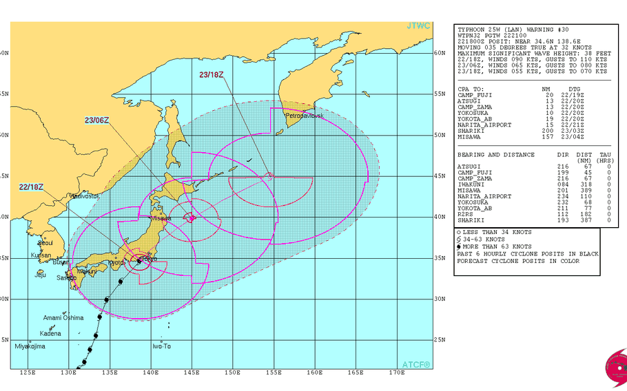
5 a.m. Monday, Oct. 23, Japan time: Typhoon Lan made landfall at about 1:40 a.m. Monday over Numazu, in central Honshu about 80 miles southwest of Tokyo. It’s currently in the Tokyo-Kanto Plain area, lashing U.S. bases with heavy rain and high winds. Fleet Activities Yokosuka and Naval Air Facility Atsugi remain in Tropical Cyclone Condition of Readiness 1-E (emergency).
At 3 a.m., Lan was 79 miles southwest of Yokosuka Naval Base and moving northeast at 37 mph, still packing 104-mph sustained winds and 127-mph gusts at center. Lan should be through the area rather quickly, given its current forward speed.
4:45 a.m. Monday, Oct. 23, Japan time: Tropical Cyclone Condition of Readiness 1-E (emergency) has been issued at Navy installations in the Kanto Plain, Fleet Activities Yokosuka and Naval Air Facility Atsugi. Sustained 58-mph winds and/or 69-mph gusts are actually occurring. STAY INDOORS until the emergency is over, responders have surveyed areas for damage and the All Clear is announced.
Midnight Sunday, Oct. 22, Japan time: Typhoon Lan continues moving at a rapid pace northeast, has lost a bit more of its punch and while it should give the Kanto Plain a hard time early Monday morning, it should be through and out of the area rather quickly, according to the Joint Typhoon Warning Center.
At 9 p.m., Lan was 267 miles southwest of Camp Fuji, rumbling northeast at 30 mph packing 121-mph sustained winds and 150-mph gusts at center. If Lan continues moving as forecast, it should knife its way between the major U.S. bases in the Kanto Plain between 4 and 5 a.m. Monday, still packing 92-mph sustained winds and 115-mph gusts as it roars past.
Fleet Activities Yokosuka and its satellite properties remain in Tropical Cyclone Condition of Readiness 1-C (caution). Expect other Kanto bases to follow suit early Monday morning, followed by TCCOR 1-E (emergency). TCCOR 1-R would follow when winds diminish below 58-mph sustained and Lan begins moving out of the area.
The high-wind warning for Yokosuka Naval Base has been extended until 3 a.m. Tuesday. Here’s the wind-forecast timeline for Fleet Activities Yokosuka:
Sunday: 52- to 58-mph sustained winds, 74-mph gusts overnight. Monday: 58- to 63-mph sustained winds and 86-mph gusts early morning to mid-day; 46- to 52-mph sustained winds and 63-mph gusts early afternoon; 29- to 35-mph sustained winds, 46-mph gusts early evening.One very important note: When your base exits TCCOR 1-E and enters 1-R, that is NOT the signal that everything is OK and you can go out. Far from it. That’s when staff civil and other survey crews move about bases looking for downed trees and power lines, flooding, building damage, overturned vehicles, etc., and establish safe zones around those hazards. Wait until the All Clear is sounded before leaving quarters.
Schools will be closed Monday along with most base service outlets. Mission-essential personnel only are expected to report for duty.
10 p.m. Sunday, Oct. 22, Japan time: Fleet Activities Yokosuka has set Tropical Cyclone Condition of Readiness 1-C (caution).
Winds up to 56 mph sustained are occurring on a particular installation within CFAY’s properties. Expect upgrade to TCCOR 1-E (emergency) for CFAY, Naval Air Facility Atsugi and other Kanto Plain installations should sustained winds exceed 58 mph sustained or 69-mph gusts.
6:30 p.m. Sunday, Oct. 22, Japan time: Typhoon Lan is losing its punch as it continues rapidly rumbling north-northeast toward the Tokyo area. Landfall is forecast for around 3 a.m. Monday between Shizuoka and Hamamatsu west of Tokyo with Lan still packing 98-mph sustained winds and 121-mph gusts at center as it rams ashore. At 3 p.m., Lan was 337 miles south-southeast of Marine Corps Air Station Iwakuni, cruising north-northeast at 24 mph packing sustained 132-mph winds and 161-mph gusts at center – still powerful, but not the Category 4-equivalent beast it once was. It should continue decaying as it moves toward Tokyo; however, the wind-field expansion forecast by Joint Typhoon Warning Center is at last happening, so the potential for destructive winds over a wide area is more than possible. U.S. bases in the Kanto Plain remain in Tropical Cyclone Condition of Readiness 1. Once winds increase past 40-mph sustained, expect upgrade to TCCOR 1-C (caution), with TCCOR 1-E (emergency) to follow, if necessary, should winds meet or exceed 58-mph sustained and/or 69-mph gusts. Fleet Activities Yokosuka’s official Facebook page indicated that might come around 3 a.m. Monday. Schools will be closed Monday along with most base services outlets, until the All Clear is sounded. Mission-essential personnel only are required for duty on Monday.
2 p.m. Sunday, Oct. 22, Japan time: U.S. bases in the Kanto Plain are in Tropical Cyclone Condition of Readiness 1. Destructive winds of 58 mph or greater are anticipated within 12 hours.
11 a.m. Sunday, Oct. 22, Japan time: Finally. Lan has finally shed super-typhoon status, but just barely. It remains a dangerous Category 4-equivalent typhoon and has really picked up forward speed as it continues hurtling headlong toward a bracing Kanto Plain. U.S. bases in the Kanto Plain remain in Tropical Cyclone Condition of Readiness 2. Okinawa has reverted to seasonal TCCOR 4, waiting and seeing with regard to Tropical Depression 27W, lurking way to the southeast of Guam. At 9 a.m., Lan was 380 miles east-northeast of Kadena Air Base, Okinawa, trucking north-northeast at 25 mph, packing 144-mph sustained winds and 173-mph gusts at center. Destructive wind bands remain close to storm’s center, but the wind field is forecast to fan out widely as Lan approaches the Tokyo area. If it remains on present course, Lan is forecast to rumble 15 miles southeast of Yokosuka Naval Base at 5 a.m. Monday, still packing 115-mph sustained winds and 132-mph gusts at center as it roars overhead. A high wind warning remains in effect for Yokosuka Naval Base until 2 a.m. Tuesday. Wind-forecast timeline for Fleet Activities Yokosuka: -- Sunday: 23- to 29-mph sustained winds and 40-mph gusts early evening; 35- to 40-mph sustained winds and 52-mph gusts late evening; 52- to 58-mph sustained winds, 74-mph gusts overnight. -- Monday: 58- to 63-mph sustained winds and 86-mph gusts early morning to mid-day; 46- to 52-mph sustained winds and 63-mph gusts early afternoon; 29- to 35-mph sustained winds, 46-mph gusts early evening. Don’t waste time preparing. Get your safe on, Kanto Plain!
7 a.m. Sunday, Oct. 22, Japan time: Fleet Activities Yokosuka has directed Tropical Cyclone Condition of Readiness 2 for Yokosuka Naval Base and its satellite properties. Destructive winds of 58 mph or greater are anticipated within 24 hours. Other Kanto Plain bases will likely follow suit shortly.
6:15 a.m. Sunday, Oct. 22, Japan time: Not only does Lan stubbornly remain a super typhoon; if anything, it’s increased in intensity, up to 155-mph sustained winds and 189-mph gusts. U.S. bases on Okinawa are in Tropical Cyclone Condition of Readiness Storm Watch. Kanto Plain bases can expect to enter TCCOR 2 any time now as Lan continues its charge toward Tokyo.
At 3 a.m., Lan was about 350 miles east of Kadena Air Base, trucking north-northeast at 20 mph. It’s already made closest point of approach regarding Okinawa. Peak winds were 39-mph sustained and 55-mph gusts at 4:30 a.m. Sunday.
While Lan’s wind field remains large, the critical 50- and 64-knot (58- and 74-mph) wind bands which bring destructive winds remain quite narrow; hence, Okinawa escaped Lan’s full wrath because its center was so far from island.
Lan should now continue moving headlong toward the Kanto Plain. U.S. bases remain in TCCOR 3; expect an upgrade at any point to TCCOR 2, with TCCOR 1 likely to be set at mid-evening Sunday. Lan is forecast to pass 22 miles southeast of Yokosuka at 3 a.m. Monday, still packing 121-mph sustained winds and 150-mph gusts as it approaches central Honshu.
A high wind warning remains in effect for Yokosuka Naval Base until 2 a.m. Tuesday. Wind-forecast timeline for Fleet Activities Yokosuka:
Sunday: 23- to 29-mph sustained winds and 40-mph gusts early evening; 35- to 40-mph sustained winds and 52-mph gusts late evening; 52- to 58-mph sustained winds, 74-mph gusts overnight. Monday: 58- to 63-mph sustained winds and 86-mph gusts early morning to mid-day; 46- to 52-mph sustained winds and 63-mph gusts early afternoon; 29- to 35-mph sustained winds, 46-mph gusts early evening.While Okinawa got fortunate, Lan is no joke; it remains a vicious, powerful storm. Time to make preparations if they haven’t already been made. Schools remain closed and mission-essential personnel only are required for duty Monday.
Midnight Saturday, Oct. 21, Japan time: Talk about stubborn. Lan just refuses to give up that super-typhoon status, remaining a Category 4-equivalent storm. But it’s begun speeding up in its relentless journey north-northeast toward a showdown with Yokosuka Naval Base early Monday, according to the Joint Typhoon Warning Center .
At 9 p.m., Lan was 353 miles east-southeast of Kadena Air Base and picking up serious forward speed, chugging north-northeast at 18 mph, but still packing 150-mph sustained winds and 184-mph gusts at center. Lan has just about reached closest point of approach regarding Okinawa, 339 miles east-southeast at about 1 a.m. Sunday.
U.S. bases on Okinawa remain in Tropical Cyclone Condition of Readiness 1. Though Lan’s wind field remains vast, destructive 58-mph wind bands remain well away from the island. It may be safe to say that accelerated TCCORs are not in the cards, but PST has learned long ago, never to say never.
As for the Tokyo area … Lan remains forecast to pass directly over Yokosuka at around 6 a.m. Monday, still packing 104-mph sustained winds and 127-mph gusts at center.
Here’s the latest wind-forecast timeline for Fleet Activities Yokosuka, which remains in TCCOR 3; expect that to be upgraded to TCCOR 2 around 3 a.m. Sunday, with other bases around the Kanto Plain to follow shortly or at the same time. Courtesy of NOAC Yokosuka’s weather Web page:
High-wind warning in effect until 2 a.m. Tuesday. Sunday: Northeast 21- to 27-mph sustained winds, 35-mph gusts most of the day; 23- to 29-mph sustained winds, 40-mph gusts, early evening; southeast 35- to 40-mph sustained, 46-mph gusts overnight. Monday: Here comes the rough stuff. Southeast 35- to 40-mph sustained, 46-mph gusts early morning; 58- to 63-mph sustained winds, 86-mph gusts mid-morning; 46- to 52-mph sustained, 63-mph gusts mid-afternoon; 29- to 35-mph sustained, 46-mph gusts early evening, diminishing overnight.Schools will be closed Monday. Mission-essential only report to work at most, if not all bases.
8 p.m. Saturday, Oct. 21, Japan time: Well, folks, for the moment, Okinawa is no longer expected to get destructive 58-mph winds as a result of Super Typhoon Lan, according to Kadena Air Base’s 18th Wing Weather Flight’s Shogun Weather site.
U.S. bases remain in Tropical Cyclone Condition of Readiness 1, and that may be about as far as it goes. Peak winds are now forecast to be 52-mph sustained and 63-mph gusts at 3 a.m. Sunday, just below TCCOR 1-E criteria. All this could change if Lan’s forecast track edges back closer to Okinawa.
6 p.m. Saturday, Oct. 21, Japan time: Further, ever further east, Super Typhoon Lan’s track continues edging away from Okinawa, perhaps allowing the island to be spared of Lan’s full fury as it roars past the island overnight Saturday into Sunday. At 3 p.m., Lan was 388 miles southeast of Kadena Air Base, headed northeast at 13 mph, still packing Category 4-equivalent strength, 150-mph sustained winds and 184-mph gusts at center. If it continues moving as forecast, Lan should pass 334 miles east-southeast of Kadena at 3 a.m. Sunday. As it continues moving on a north-northeast forecast track, Lan is projected to start picking up forward speed while losing its punch as it progresses. But Tokyo still remains a prime target for Lan and U.S. bases there remain in TCCOR 3, with TCCOR 2 expected to be set at Fleet Activities Yokosuka at 3 a.m. Sunday. Most services and schools at U.S. bases in the Kanto Plain will be closed; mission essential personnel only should report for duty at most installations. If Lan remains on course, it’s expected to pass 20 miles southeast of Yokosuka at 6 a.m. Monday, still packing 110-mph sustained winds and 127-mph gusts at center as it approaches the Tokyo area.
2:30 p.m. Saturday, Oct. 21, Japan time: Here is the latest wind-forecast timeline for Super Typhoon Lan, courtesy of Kadena Air Base’s 18th Wing Weather Flight.
Though Lan is still forecast to pass some 300 miles east of Okinawa, the wind field remains wide enough to present destructive winds for a brief period overnight Saturday into Sunday.
Sustained winds of 40 mph or greater: 3 p.m. Saturday Sustained winds of 58 mph or greater: 9 p.m. Saturday Peak winds of 58-mph sustained and 63-mph gusts: 1 a.m. Sunday Winds subsiding below 58-mph sustained: 3 a.m. Sunday Winds subsiding below 40-mph sustained: 3 p.m. SundayNote that all these times may change. U.S. bases on Okinawa remain in Tropical Cyclone Condition of Readiness 1. Expect TCCOR 1-C to be declared at 3 p.m., at which point folks should head to quarters or someplace safe. TCCOR 1-E will likely be issued at 9 p.m.; at that point, all outdoor activity is prohibited. TCCOR 1-R would follow when winds drop below 58-mph sustained. That does NOT mean people may leave their quarters. Stay indoors until the All Clear is sounded.
11:30 a.m. Saturday, Oct. 21, Japan time: Let’s not get our hopes up just yet, campers. Yes, Lan’s forecast track is edging further east of Okinawa than we previously reported, and its 64-knot (74-mph) and 50-knot (58-mph) wind bands appear to also leave the island out of harm’s way.
Still, U.S. bases on Okinawa are in Tropical Cyclone Condition of Readiness 1 for a reason: It’s a super typhoon, having peaked at 155-mph sustained winds and 190-mph gusts at center, and is forecast to remain a super typhoon as it passes 313 miles east-southeast of Kadena Air Base at 1 a.m. Sunday.
The slightest move back west, and Okinawa will suffers Lan’s full wrath. Nevertheless, Lan is still a dangerous beast and it could yet unleash a dangerous roundhouse punch to the island.
At 9 a.m., Lan was 412 miles south-southeast of Kadena, moving northeast at 9 mph. Current wind-forecast timeline still shows Okinawa experiencing destructive winds between 9 p.m. Saturday and 9 a.m. Sunday. Peak winds should occur at 1 a.m. Sunday, at closest point of approach.
And the Kanto Plain remains in Lan’s sights. U.S. bases remain in TCCOR 3 there. Lan is forecast to pick up forward speed as it approaches land and retain a powerful Category 1-equivalent punch, passing 13 miles southeast of Yokosuka Naval Base at 8 a.m. Monday, packing 81-mph sustained winds and 98-mph gusts, but move through the area quickly, with gradual clearing behind it.
Updated wind-forecast timeline from Kadena's 18th Wing Weather Flight when available.
10 a.m. Saturday, Oct. 21, Japan time: U.S. bases in the Kanto Plain have set Tropical Cyclone Condition of Readiness 3. Destructive winds of 58 mph or greater are possible within 48 hours. Expect upgraded to TCCOR 2 around mid-morning Sunday.
8 a.m. Saturday, Oct. 21, Japan time: Though Lan’s storm center is forecast to pass nearly 300 miles from Okinawa, it’s still a super typhoon. And its wind field is wide enough, typhoon-force winds extending 105 miles from storm’s center, to bring destructive winds of 58 mph or greater for a significant period to Okinawa.
Here’s the latest wind-forecast timeline for Okinawa from Kadena Air Base’s 18th Wing Weather Flight. U.S. bases remain in Tropical Cyclone Condition of Readiness 1:
Sustained winds of 40 mph or greater (upgrade to TCCOR 1-C): 3 p.m. Saturday. Sustained winds of 58 mph or greater (upgrade to TCCOR 1-E): 9 p.m. Saturday. Peak winds, 58-mph sustained, 69-mph gusts: 3 a.m. Sunday. Winds diminishing below 58-mph sustained (possibly entering TCCOR 1-R): 9 a.m. Sunday. Winds diminishing below 40-mph sustained: Midnight Sunday.A reminder: Leaving TCCOR 1-E and entering TCCOR 1-R Is not the signal that you can go outside. Far from it. That’s when survey crews go out to inspect bases for damage, flooding, downed power lines, trees and tree limbs, overturned vehicles, building damage and so on. Wait until All Clear is issued.
6:30 a.m. Saturday, Oct. 21, Japan time: The bad news: Lan has intensified rapidly into a super typhoon and is forecast by the Joint Typhoon Warning Center to peak at 161-mph sustained winds and 196-mph gusts at center later Saturday.
The slightly better news, if there is such a thing with major tropical cyclones: Lan’s wind field has diminished somewhat, according to the National Weather Service. Typhoon-force winds extend 105 miles from center; previously, it was 140. Tropical storm-force winds extend 330 miles southeast of center and 260 miles northwest, a bit less than before.
At 3 a.m., Lan was 440 miles south-southeast of Kadena Air Base, Okinawa, tracking northeast at 7 mph, packing 150-mph sustained winds and 184-mph gusts at center. If it continues on its present course, Lan is due to pass 298 miles east-southeast of Kadena at 3 a.m. Sunday.
Again, slightly better news: Lan’s 50-knot (58-mph) wind bands, containing those destructive winds we worry so much about, have edged a bit further east of the island. That does NOT mean Okinawa is out of the woods. U.S. bases on Okinawa remain in Tropical Cyclone Condition of Readiness 1. PST will post an updated wind forecast timeline when it becomes available. https://shogunweather.com/tropicalcycloneforecast/ In the long term, Lan is forecast to begin tracking rapidly northeast toward Tokyo, on path to take it directly over Yokosuka Naval Base at 6 a.m. Monday, remaining a powerful Category 1-equivalent storm, 86-mph sustained winds and 104-mph gusts as it makes landfall. U.S. bases in the Kanto Plain remain in TCCOR 4; expect that to be upgraded by 9 a.m.
Fleet Activities Yokosuka can expect the following wind timeline:
Overnight Sunday, early Monday: Southeasterly winds 35- to 40-mph sustained, 52-mph gusts. Mid-morning Monday: 52- to 58-mph sustained winds, 69-mph gusts. Mid-day Monday: 58- to 63-mph sustained winds, 81-mph gusts. Late afternoon: 46- to 52-mph sustained winds, 63-mph gusts. Late evening: 18- to 23-mph sustained winds, 35-mph gusts.More information as it becomes available.
12:30 a.m. Saturday, Oct. 21, Japan time: Here’s the current updated Tropical Cyclone Condition of Readiness scoreboard. Expect these numbers to upgrade as Typhoon Lan gets closer; these could change depending on Lan’s track and wind field:
Okinawa: TCCOR 1. Expect TCCOR 1-C by 3 a.m. local time, TCCOR 1-E by 9 p.m. Saturday. Lan is forecast to pass 263 miles southeast of Kadena Air Base at 11 p.m. Saturday, at which time peak winds of 58-mph sustained and 69-mph gusts are anticipated.
Sasebo Naval Base: No TCCORs expected to be declared at this time. Lan is due to pass 330 miles southeast at 6 p.m. Sunday.
Marine Corps Air Station Iwakuni: TCCOR Storm Watch; could be upgraded, since Iwakuni is currently forecast to be just inside Lan’s 50-knot (58-mph) wind bands. Lan is due to pass 246 miles southeast at 10 p.m. Sunday.
U.S. bases in Kanto Plain: TCCOR 4. Expect TCCOR 3 to be issued around 9 a.m. Saturday, TCCOR 2 about 9 a.m. Sunday and TCCOR 1 around 9 p.m. Sunday. Lan is due to pass almost directly over Yokota Air Base around 7 a.m. Monday, remaining a strong Category 1-equivalent typhoon with gusts up to 100 mph at center. A high-wind warning is in effect for Yokosuka Naval Base between 9 p.m. Saturday and 2 a.m. Tuesday.
10 p.m. Friday, Oct. 20, Japan time: U.S. bases on Okinawa have been place in Tropical Cyclone Condition of Readiness 1. Destructive winds of 58 mph or greater are anticipated within 12 hours. Also, Marine Corps Air Station Iwakuni has directed TCCOR Storm Watch.
7 p.m. Friday, Oct. 20, Japan time: All U.S. bases in the Kanto Plain have entered Tropical Cyclone Condition of Readiness 4. Destructive winds of 58 mph or greater are possible within 72 hours.
5:30 p.m. Friday, Oct. 20, Japan time: Typhoon Lan continues intensifying and is still expected to rake Okinawa with strong winds and up to 4 inches of rain Saturday night into Sunday. But according to the Joint Typhoon Warning Center, projected landfall over Honshu might be a bit further west of Tokyo than previously forecast. At 3 p.m., Lan was 490 miles south-southeast of Kadena Air Base, moving north-northeast at 10 mph, its intensity increased to 104-mph sustained winds and 127-mph gusts. It’s still forecast to peak as a strong Category 3-equivalent typhoon, 132-mph sustained winds and 161-mph gusts at mid-afternoon Saturday. Lan is forecast to pass 267 miles east-southeast of Kadena at midnight Saturday. That’s pretty far, but Lan’s wind field is massive – typhoon-force winds continue to extend 140 miles from center, and tropical storm-force winds 405 miles east and south of center and 265 miles northwest, according to the National Weather Service on Guam. Hence, why U.S. bases on Okinawa remain in Tropical Cyclone Condition of Readiness 2. Expect that to be upgraded sometime Friday evening or early Saturday morning, with TCCOR 1-C to follow soon after. Destructive winds of 58 mph or greater remain forecast for 9 p.m. Saturday to 9 a.m. Sunday, with peak 58-mph sustained winds and 69-mph gusts at midnight Saturday. Note that these times could change. Fleet Activities Yokosuka remains in TCCOR 4. Yokosuka Naval Base and its satellite properties will be closed on Monday. Mission essential personnel only required to report to work. A high-wind warning is in effect from 9 p.m. Saturday until 2 a.m. Tuesday, according to CFAY’s five-day forecast.
As to the wheres and whens Lan might actually affect the Kanto Plain, model guidance remains spread. They agree on a general track northeast through central Honshu. JTWC projects Lan to pass 29 miles southeast of Yokota Air Base and 59 miles northwest of Yokosuka at 9 a.m. Monday. But models continue to disagree on track speed and landfall timing.
2:30 p.m. Friday, Oct. 20, Japan time: Fleet Activities Yokosuka and its satellite properties to include Ikego Heights Naval Housing Facility have set Tropical Cyclone Condition of Readiness 4. Destructive winds of 58 mph or greater are possible within 72 hours.
Expect upgraded TCCORs starting Saturday, TCCOR 3 at 9 a.m., TCCOR 2 at 9 a.m. Sunday and TCCOR 1 at 9 p.m. Sunday. Only mission essential personnel report for duty Monday. Schools will be closed. The first day of the DODEA-Pacific Far East cheerleading competition is also canceled. Stay tuned to CFAY’s TV access channel and CFAY’s official Facebook page for future announcements.
Other bases in the Kanto Plain can anticipate similar measures in the run-up to Typhoon Lan’s forecast arrival Monday.
12:30 p.m. Friday, Oct. 20, Japan time: U.S. bases on Okinawa have entered Tropical Cyclone Condition of Readiness 2. Destructive winds of 58 mph or greater are anticipated within 24 hours.
12:30 p.m. Friday, Oct. 20, Japan time: Typhoon Lan has started to arc northeast, its peak forecast winds adjusted upward, to 132-mph sustained winds and 161-mph gusts at center sometime Saturday evening. Joint Typhoon Warning Center still projects Lan to pass through Tokyo area, but models diverge on whether it will strike Tokyo or further west, over central Honshu and when it will make landfall.
At 9 a.m., Lan was 550 miles south-southeast of Kadena Air Base, Okinawa, rumbling north-northeast at 9 mph, its core winds having increased to 98-mph sustained and 121-mph gusts by mid-evening Saturday. U.S. bases on Okinawa remain in Tropical Cyclone Condition of Readiness 3; expect that to be upgraded by mid-evening Friday to TCCOR 2, with TCCOR 1 to be issued Saturday morning.
If it remains on its current path, Lan should pass 260 miles east-southeast of Kadena at 1 a.m. Sunday, though its wind field remains vast – typhoon-force winds extending 140 miles from storm’s center and tropical storm-force winds 390 to the east and south and 250 miles to the northwest. Destructive winds of 58 mph or greater are forecast to occur on Okinawa between 9 p.m. Saturday and 9 a.m. Sunday, with peak winds of 58-mph sustained and 69-mph gusts at 1 a.m. Sunday.
JTWC forecasts Lan to continue northeast, passing 331 miles southeast of Sasebo Naval Base and 245 miles southeast of Marine Corps Air Station Iwakuni, still clinging to 115-mph sustained winds and 132-mph gusts as it approaches land.
Then, there’s the issue of the Tokyo-Kanto Plain area. Current JTWC track projects Lan to pass 20 miles southeast of Yokota Air Base and 50 miles northwest of Yokosuka Naval Base between 11 a.m. and noon Monday, remaining a significant cyclone with 98-mph sustained winds and 121-mph gusts.
But models diverge, both as to where Lan makes landfall and when. GFS ensemble projects landfall over the Kansai region, Nagoya or Osaka; https://www.tropicaltidbits.com/storminfo/25W_geps_latest.png is a bit more scattered but consensus shows landfall over Tokyo, some tracks showing a slower approach, others more rapid.
https://metoc.ndbc.noaa.gov/ProductFeeds-portlet/img/noacyoko/fiveday_yoko.htm for Yokosuka shows winds picking up Saturday evening, 18- to 23-mph sustained winds and 35-mph gusts, increasing to 23- to 29-mph sustained Sunday evening with 40-mph gusts, then 35- to 40-mph sustained with 46-mph gusts overnight Sunday.
9:45 a.m. Friday, Oct. 20, Japan time: Slight adjustment to the wind-forecast timeline from Kadena Air Base’s 18th Wing Weather Flight. U.S. bases remain in Tropical Cyclone Condition of Readiness 3:
Sustained 40-mph winds or greater: 3 a.m. Saturday Sustained 58-mph winds or greater: 9 p.m. Saturday Peak 58-mph sustained winds and 69-mph gusts: Midnight Saturday Winds diminishing below 58-mph sustained: 9 a.m. Sunday Winds diminishing below 40-mph sustained: Midnight SundayNote that these times may change. In general, when sustained winds reach 40 mph, that’s around the time that TCCOR 1-C (caution) is declared by the 18th Wing commanding officer. At 58-mph sustained, that’s generally when TCCOR 1-E (emergency) is issued; all outdoor activity is prohibited.
When winds subside below 58-mph sustained, that’s generally when TCCOR 1-R (recovery) is declared. That does NOT mean it’s OK to go outside! Quite the contrary; that’s the time when it’s MOST important to remain INDOORS.
Why? Because bases need to be surveyed for damage by civil engineers and other responders. Downed trees and limbs, downed power lines, facilities damage, flooding, overturned vehicles and so on. TCCOR 1-R could last but a couple of hours; it could last a day or longer, depending on how much needs to be repaired.
Bottom line: Best to stay indoors from TCCOR 1-C until the All Clear is declared or seasonal TCCOR 4 resumes.
6 a.m. Friday, Oct. 20, Japan time: The slightly better news, if there is such a thing, is that Typhoon Lan’s forecast peak winds have been adjusted, to 121-mph sustained and 150-mph gusts at 3 p.m. Saturday. Lan is forecast to pass 255 miles east-southeast of Okinawa at about midnight Saturday, according to the Joint Typhoon Warning Center.
The bad news: This storm is no joke, folks. The wind field is very wide; typhoon-force winds extend outward about 140 miles from Lan’s center, according to the National Weather Service on Guam. Tropical storm-force winds extend up to 420 miles southeast of center and 240 miles northwest.
So, Okinawa should still feel quite the roundhouse punch from Lan. We’re still looking at destructive winds of 58 mph or greater between 9 p.m. Saturday and 3 p.m. Sunday, with peak 58-mph sustained winds and 69-mph gusts at 7 a.m. Sunday, according to Kadena Air Base’s Shogunweather.com Web site.
At 3 a.m., Lan was 600 miles south-southeast of Kadena, rumbling north at 12 mph, holding steady at 86-mph sustained winds and 104-mph gusts, Category 1-equivalent. U.S. bases on Okinawa remain in Tropical Cyclone Condition of Readiness 3. Expect that to be upgraded sometime Friday evening, depending on Lan’s track and how quickly it moves.
Even Marine Corps Air Station Iwakuni and Sasebo Naval Base might feel some effects from Lan’s expansive wind field. Lan is forecast to pass 345 miles southeast of Sasebo at 10 p.m. Sunday and 266 miles southeast of Iwakuni six hours later, still packing 98-mph sustained winds and 121-mph gusts at center – and Iwakuni might end up just inside Lan’s 50-knot (58-mph) wind bands.
And Lan is next forecast to pass right over the Tokyo-Kanto Plain area by mid-day Monday, still maintaining 92-mph sustained winds and 115-mph gusts as it approaches. More specifics on wind timelines and TCCOR changes as it gets closer.
5:15 p.m. Thursday, Oct. 19, Japan time: Yokosuka Naval Base could be in for a direct or near-direct hit from Typhoon Lan sometime Monday evening, according to the latest Joint Typhoon Warning Center forecast track. At 3 p.m., Lan was 720 miles south-southeast of Kadena Air Base, Okinawa, headed north-northwest at 12 mph and had intensified to 86-mph sustained winds and 104-mph gusts at center. Lan remains forecast to peak at 138-mph sustained winds and 167-mph gusts around mid-afternoon Saturday before it begins arcing on a path taking it east of Okinawa, but close enough for accelerated Tropical Cyclone Conditions of Readiness. If Lan keeps moving as forecast, it’s due to pass 235 miles east-southeast of Kadena Air Base, still packing 127-mph sustained winds and 155-mph gusts at center as it roars past. U.S. bases on Okinawa remain in TCCOR 3; expect that to change by morning. Destructive winds of 58 mph or greater are forecast from 9 p.m. Saturday to 3 p.m. Sunday, but that could change, depending on Lan’s track. As for the Tokyo area, JTWC projects Lan to remain a strong Category 2-equivalent storm, packing 110-mph sustained winds and 127-mph gusts at center as it rumbles 7 miles east of Yokosuka and an equal distance west of Narita International Airport between 10 and. 11 p.m. Monday. But Lan should move through rather rapidly out of the area into the northwest Pacific Ocean soon after.
2:30 p.m. Thursday, Oct. 19, Japan time: Here’s the projected wind-forecast timeline for Okinawa if Typhoon Lan continues moving as forecast, according to Kadena Air Base’s 18th Wing Weather Flight’s Shogunweather.com Web site:
-- Sustained 40-mph winds or greater: From 5 a.m. Saturday. -- Sustained 58-mph winds or greater: From 9 p.m. Saturday. -- Peak winds of 58-mph sustained, 69-mph gusts: 10 a.m. Sunday. -- Winds diminishing below 58-mph sustained: 3 p.m. Sunday. -- Winds diminishing below 40-mph sustained: Midnight Sunday.
2 p.m. Thursday, Oct. 19, Japan time: U.S. bases on Okinawa have entered Tropical Cyclone Condition of Readiness 3. Destructive winds of 58 mph or greater are possible within 48 hours.
12:30 p.m. Thursday, Oct. 19, Japan time: Typhoon Lan is currently following a path that places the storm roughly 230 miles east of Okinawa, while Tokyo could be in for a fairly savage blow on Tuesday morning, according to the Joint Typhoon Warning Center’s latest forecast.
At 9 a.m. JST, Lan was 715 miles south-southeast of Kadena Air Base, moving northwest at 12 mph, holding steady with 75-mph sustained winds and 92-mph gusts. It’s forecast to peak at 138-mph sustained and 167-mph gusts at 9 a.m. Saturday. Lan is already a massive beast – more than 1,300 miles across in terms of full diameter, according to a JTWC official. This storm is no joke, folks.
If it stays on its current path, Lan could sideswipe Okinawa, missing it by about 230 miles at mid-morning Sunday with the island just outside of Lan’s destructive 50-knot (58-mph) wind bands. But, that’s all contingent on Lan’s progress and track, which could easily change. U.S. bases on Okinawa remain in seasonal Tropical Cyclone Condition of Readiness 4, which is expected to change later Friday.
Tokyo is next on Lan’s itinerary. It’s forecast to maintain Category 2-equivalent strength as it approaches the Kanto Plain, still packing 110-mph sustained winds and 132-mph gusts at center as it creeps within 35 miles of Yokosuka Naval Base at 4 a.m. Tuesday. Vast portions of the Kanto Plain are forecast to be within Lan’s 50-knot and 64-knot wind bands. Such weather is unusual in the Tokyo area at this time of year — but Lan is a very unusual storm.
6 a.m. Thursday, Oct. 19, Japan time: Slightly better news for Okinawa, but not that much better; Joint Typhoon Warning Center’s latest forecast track takes Typhoon Lan a bit further east of the island than previously reported, but still close enough to bring seriously high winds and heavy rain throughout the weekend, according to local forecasts.
At 3 a.m., Typhoon Lan was about 860 miles south-southeast of Kadena Air Base, moving north-northwest at 9 mph, holding steady at 75-mph sustained winds and 92-mph gusts. Another bit of slightly better news; Lan is currently forecast to peak just below super-typhoon strength, 144-mph sustained winds and 173-mph gusts at center while still well out to sea.
Kadena’s Shogunweather.com long-range forecast calls for winds picking up by Friday afternoon, 28-mph sustained winds and 46-mph gusts. Expect that to increase on Saturday, 35- to 43-mph sustained winds and 58- to 69-mph gusts. Sunday’s forecast calls for 46-mph sustained winds in the morning with 70-mph gusts, decreasing to 40 and 68 by afternoon. U.S. bases on Okinawa remain for now in seasonal Tropical Cyclone Condition of Readiness 4; that may change, and very soon.
Long term, Lan is projected to head in Tokyo’s general direction by early morning Tuesday, 71 miles south-southeast of Camp Fuji by 3 a.m. Tuesday, still packing 115-mph sustained winds and 140-mph gusts at center.
Unusual for this time of year, since it’s getting cooler in the Tokyo area. But this is no ordinary storm. It’s expected to remain strong. And large. Wide in diameter, wind bands expected to stretch as far west as Kyushu as Lan treks northeast. A dangerous beast. Time to start preparing.
6:30 p.m. Wednesday, Oct. 18, Japan time: Typhoon Lan continues its journey north, splitting the difference between the Philippines and Marianas and its latest projected track takes Lan a bit closer to Okinawa than previously forecast, according to the Joint Typhoon Warning Center.
At 5:30 p.m., Lan was 975 miles south-southeast of Kadena Air Base, moving north at 12 mph with 75-mph sustained winds and 92-mph gusts. Lan remains forecast to peak as a Category 5-equivalent super typhoon, 150-mph sustained winds and 184-mph gusts, briefly at mid-afternoon Friday before weakening as it reaches cooler waters up north.
Closest point of approach to Kadena is now 210 miles east-southeast at 7 a.m. Sunday. But Lan will remain a dangerous and very wide storm. Current projections show Okinawa just inside Lan’s forecast 50-knot (58-mph) wind bands, which generally means upgraded Tropical Cyclone Conditions of Readiness, perhaps as soon as Thursday morning, according to Kadena’s 18th Wing Weather Flight. U.S. bases for the moment remain in seasonal TCCOR 4; that could change by morning.Models continue to depict a track east of Okinawa, headed in the general direction of Tokyo by Monday or Tuesday, with Lan transitioning into a cold-core low, but still retaining gale-force or typhoon-strength winds as it heads north and northeast.
Noon Wednesday, Oct. 18, Japan time: Lan has strengthened into a Category 1-equivalent typhoon and has picked up forward speed as it commences its long journey north toward a possible rendezvous with Japan by the weekend or early next week, according to the Joint Typhoon Warning Center.
At 11:15 a.m., Lan was about 1,090 miles south-southeast of Kadena Air Base, Okinawa, headed north at 12 mph, packing 75-mph sustained winds and 92-mph gusts at center. It appears as though Lan should not impact the Philippines, well to the west, though Lan remains in that country’s area of responsibility.
If Lan remains on its current path, it’s forecast to pass about 255 miles east-southeast of Kadena at 1 a.m. Sunday as a Category 4-equivalent typhoon, 138-mph sustained winds and 167-mph gusts at center. Kadena’s Shogunweather.com’s long-range forecast calls for winds peaking at 36-mph sustained and gusts up to 55 mph Saturday evening into Sunday.
U.S. bases on Okinawa remain in seasonal Tropical Cyclone Condition of Readiness 4 for now. This is forecast to be a massive storm and Kadena and other parts of Okinawa could fall inside Lan’s 50-knot (58-mph) wind bands, which could necessitate accelerated TCCORs later this week.
Long-range models remain in agreement on a track taking Lan toward Honshu, crossing just north of the Tokyo area by early next week, not as a tropical system but as a cold-core low with at least gale-force and perhaps typhoon-strength winds. PST will keep a sharp lookout.
7 a.m. Wednesday, Oct. 18, Japan time: Like a cat crouched and ready to pounce, Tropical Storm Lan remains lurking well south of Japan, but ready to head northward. The forecast calls for a wet, gusty weekend on Okinawa and a similar start to next week in Honshu, according to the Joint Typhoon Warning Center.
At 3 a.m., Lan was 1,115 miles south-southeast of Kadena Air Base, crawling north at 4 mph packing 69-mph sustained winds and 86-mph gusts at center. Once Lan gets going and picks up forward speed, it should become a typhoon sometime Wednesday afternoon.
JTWC projects Lan to peak at 150-mph sustained winds and 184-mph gusts at 3 a.m. Saturday, just after crossing the 20th parallel, then weakening from there as it hits cooler waters in the north.
However, Lan is still forecast to be a massive storm in terms of total diameter. Its 34-knot (40-mph) wind bands stretch 15 degrees across, from Ishigaki in the southwestern islands to about 200 miles west of Iwo Jima.
What it means for Okinawa is much like what occurred with Super Typhoon Chaba last year. If Lan remains on course, the storm center should miss Okinawa to the east, with the island enduring 36-mph sustained winds and gusts up to 55 mph Saturday night into Sunday morning, along with showers and isolated thunderstorms.
U.S. bases on Okinawa remain in seasonal Tropical Cyclone Condition of Readiness 4. Model guidance is in good agreement. Still, if Lan’s track edges a degree or three west, all that could change. Best to start preparing for the worst in case that happens.
Midnight Tuesday, Oct. 17, Japan time: Whoo-wee, is Lan forecast to become not just powerful, but a massive tropical cyclone as it rumbles north, according to the Joint Typhoon Warning Center. http://www.usno.navy.mil/NOOC/nmfc-ph/RSS/jtwc/warnings/wp2517.gif While storm’s center is projected to pass about 260 miles east-southeast of Kadena Air Base early Saturday morning, Lan’s 50-knot (58-mph) wind bands are depicted to edge very close to Okinawa, with the island expected to feel some serious gale-force winds as it passes. At 9 p.m., Lan was 1,150 miles south-southeast of Kadena, holding quasi-stationary with 63-mph sustained winds and 81-mph gusts. If it stays on its forecast path, Lan is forecast to peak as a super typhoon, 150-mph sustained winds and 184-mph gusts, at mid-evening Thursday, weakening slightly as it continues north and hits cooler waters north of the Tropic of Cancer. Gale-force winds are forecast to extend a vast distance from Lan’s center, stretching all the way to Okinawa. Kadena’s Shogunweather.com’s extended forecast continues to show winds picking up Thursday afternoon, reaching 38-mph sustained and 54- to 56-mph gusts by Saturday afternoon and evening. U.S. bases on Okinawa remain in seasonal Tropical Cyclone Condition of Readiness 4 for now.
8:30 a.m. Tuesday, Oct. 17, Japan time: Tropical Storm Lan continues slowly tracking west, but it forecast to turn sharply north sometime later Tuesday, then become a super typhoon early Saturday morning but remain well east of Okinawa, according to the Joint Typhoon Warning Center.
Noon Monday, Oct. 16, Japan time: Lan has very quickly developed into a tropical storm and could become a Category 4-equivalent by Friday morning well southeast of Okinawa, according to the Joint Typhoon Warning Center. At noon, Lan was 1,230 miles south-southeast of Kadena Air Base, tracking northwest at 10 mph. If it remains on its current forecast track. Lan is projected to come within 340 miles southeast of Kadena, and as a Category 4-equivalent storm, 132-mph sustained winds and 161-mph gusts, but at storm’s center. Models remain spread out. Most indicate a track well east of Okinawa; others depict a track closer to the island and the Philippines. PST has an eye on it.
8 a.m. Monday, Oct. 16, Japan time: A new tropical depression, the 25th numbered storm of the season, has formed just west of Yap and is forecast by the Joint Typhoon Warning Center to become a Category 3-equivalent typhoon by early Friday. The initial JTWC track takes 25W in a northerly direction, coming within 350 miles southeast of Okinawa at 3 a.m. Friday. PST will keep an eye on 25W’s path and progress.
