()
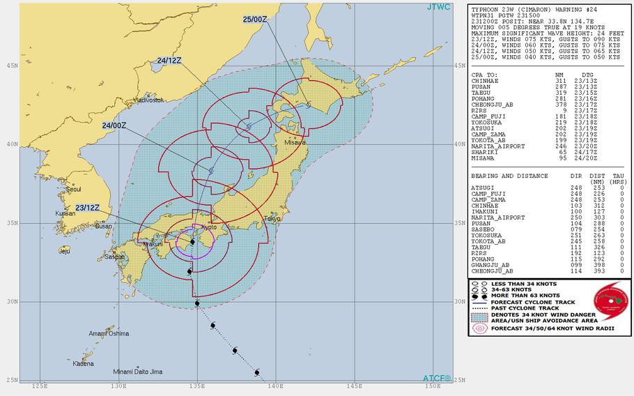
2 a.m. Friday, Aug. 24, Japan time: Closest point of approach by Typhoon Cimaron for Marine Corps Air Station Iwakuni has come and gone, though it remains in Tropical Cyclone Condition of Readiness Storm Watch, as does Fleet Activities Yokosuka well to the east.
Cimaron made landfall over the Osaka-Kobe area around midnight and is forecast to curve northeast back over water in the Sea of Japan, 110 miles northwest of Misawa Air Base early Saturday morning, then die out east of Hokkaido over the weekend. This is the final report on Cimaron.
7 p.m. Wednesday, Aug. 22, Japan time: Marine Corps Air Station Iwakuni’s weather service branch has directed Tropical Cyclone Condition of Readiness Storm Watch, meaning destructive winds are no longer forecast to impact Iwakuni. Fleet Activities Yokosuka remains in TCCOR Storm Watch.
Noon Wednesday, Aug. 22, Japan time: Typhoon Cimaron has finished buzzing Iwo Jima just to its west with 127-mph sustained winds and 155-mile gusts at center, and remains focused on forecast landfall over Osaka early Friday morning.
If Cimaron continues moving as forecast, it will pass 149 miles east of Marine Corps Air Station Iwakuni and 267 miles west-northwest of Yokosuka Naval Base between 10 p.m. Thursday and 3 a.m. Friday as a Category 1-equivalent typhoon. Iwakuni remains in Tropical Cyclone Condition of Readiness 3 and Yokosuka in TCCOR Storm Watch.
6:30 p.m. Tuesday, Aug. 21, Japan time: Typhoon Cimaron has intensified slightly, and the Joint Typhoon Warning Center’s latest forecast track takes it just a big further east of Marine Corps Air Station Iwakuni, which remains in Tropical Cyclone Condition of Readiness 3. Fleet Activities Yokosuka, meanwhile, remains in TCCOR Storm Watch.
At 6:15 p.m., Cimaron was 1,127 miles southeast of Iwakuni and 550 miles north of Guam, moving northwest at 18 mph and had strengthened to 86-mph sustained winds and 104-mph gusts. Typhoon-force winds extend 80 miles east and 60 miles west of center, and tropical storm-force winds 200 miles east and 160 miles west of center, according to the National Weather Service on Guam.
If Cimaron remains on its current course, it should pass 67 miles southwest of Iwo Jima at 7 a.m. Tuesday, having peaked at 98-mph sustained winds and 121-mph gusts at center.
Cimaron is then due to make landfall in the Osaka-Kobe area of central Japan early Thursday evening, then curve northeast into the Sea of Japan over Hokkaido, then die out over the northwest Pacific Ocean sometime this weekend.
6 a.m. Tuesday, Aug. 21, Japan time: The tropical storm warning has been canceled for Saipan and Tinian, according to the National Weather Service.
The latest forecast track from the Joint Typhoon Warning Center puts Typhoon Cimaron a bit closer to Marine Corps Air Station Iwakuni, which remains in Tropical Cyclone Condition of Readiness 3. Fleet Activities Yokosuka remains in TCCOR Storm Watch.
At 3 a.m., Cimaron was 410 miles north-northeast of Guam, holding steady at 75-mph sustained winds and 92-mph gusts. Typhoon-force winds extend 45 miles from center except in the southwest quadrant. Tropical storm-force winds extend 205 miles south and 175 miles north, according to the NWS.
If Cimaron continues on its present course, it’s forecast to pass 123 miles east of Iwakuni at 8 p.m. Thursday, still packing 75-mph sustained winds and 92-mph gusts at storm’s center, and 300 miles west-northwest of Yokosuka at midnight Thursday. Some slight differences remain in model guidance. Stay tuned.
11:45 p.m. Monday, Aug. 20, Japan time: Typhoon Cimaron’s latest forecast track sends it right down the middle, between Marine Corps Air Station Iwakuni and Yokosuka Naval Base and right over Osaka late Thursday evening.
Iwakuni remains in Tropical Cyclone Condition of Readiness 3, while Fleet Activities Yokosuka remains in TCCOR Storm Watch.
At 11 p.m., Cimaron was 1,409 miles southeast of Iwakuni, moving north-northwest at 13 mph holding steady at 75-mph sustained winds and 92-mph gusts. A tropical storm warning remains in effect for Saipan and Tinian. Typhoon-force winds extend 40 miles from center and tropical storm-force winds 215 miles south and 165 miles north, according to the National Weather Service.
If Cimaron remains on its current course, it’s forecast make landfall at 9 p.m. Thursday, barely maintaining Category 1-equivalent typhoon status, and passing 170 miles east of Iwakuni and 244 miles northwest of Yokosuka between 10 p.m. Thursday and 5 a.m. Friday.
7 p.m. Monday, Aug. 20, Japan time: Marine Corps Air Station Iwakuni has entered Tropical Cyclone Condition of Readiness 3. Destructive winds of 58 mph or greater are possible within 48 hours.
6:30 p.m. Monday, Aug. 20, Japan time: Fleet Activities Yokosuka has set Tropical Cyclone Condition of Readiness Storm Watch as a precaution prior to the forecast arrival of Typhoon Cimaron Thursday evening over central Japan.
Cimaron was 370 miles northeast of Guam at 4 p.m. Guam time, holding steady at 75-mph sustained winds and 92-mph gusts. Typhoon-force winds extend 35 miles from center and tropical storm-force winds 220 miles south and 115 miles north, according to the National Weather Service on Guam.
Cimaron is forecast by Joint Typhoon Warning Center to peak at 92-mph sustained winds and 115-mph gusts as it approaches Iwo Jima at around 3 a.m. Wednesday. Cimaron is due to pass 98 miles southwest of Iwo Jima at 8 a.m. Wednesday.
From there, Cimaron is forecast to head northwest and make landfall about 9 p.m. Thursday just west of Kobe, in central Japan. Cimaron is due to pass 130 miles east of Marine Corps Air Station Iwakuni and 280 miles west of Yokosuka between 10 p.m. Thursday and 7 a.m. Friday.
11:30 a.m. Monday, Aug. 20, Japan time: Cimaron has been upgraded to a Category 1-equivalent typhoon by the Joint Typhoon Warning Center. It remains on track to brush past Iwo Jima on Tuesday, then crash ashore Thursday evening just west of Osaka.
A tropical storm warning remains in effect for Saipan and Tinian, while a flash-flood watch and a small-craft advisory remain in effect for Guam and Rota, according to the National Weather Service on Guam.
At 10 a.m., Cimaron was 330 miles northeast of Guam, moving northwest at 14 mph, packing 75-mph sustained winds and 92-mph gusts.
If Cimaron continues moving as forecast, it should pass 88 miles southwest of Iwo Jima, packing 98-mph sustained winds and 121-mph gusts. Landfall is forecast for mid-evening Thursday, gradually weakening as it moves north.
1 a.m. Monday, Aug. 20, Guam time: Tropical Storm Cimaron continues to gather steam as it keeps heading northwest, and is forecast by the Joint Typhoon Warning Center to become a typhoon at mid-morning Monday. The latest track takes Cimaron ashore over Osaka early Friday morning.
At 10 p.m. Sunday, Cimaron was 420 miles east-northeast of Guam, headed northwest at 8 mph packing 63-mph sustained winds and 81-mph gusts. Tropical storm-force winds extend 145 miles east of center and 100 miles west, according to the National Weather Service on Guam. A tropical storm watch remains in effect for Saipan and Tinian.
Landfall for Cimaron could take place in the wee hours of Friday morning, with Cimaron still packing 86-mph sustained winds and 104-mph gusts as it moves ashore, splitting the difference between Marine Corps Air Station Iwakuni, 152 miles east, and Camp Fuji, 213 miles west, between 3 and 10 a.m. Friday.
7 p.m. Sunday, Aug. 19, Guam time: Though Tropical Storm Cimaron remains quite far east, it’s causing enough of a ruckus that a tropical storm watch is in effect for Saipan and Tinian in the Marianas Islands, according to the National Weather Service on Guam. Winds between 39 and 73 mph are possible in the next two days.
Nearer home on Guam, a high-surf and small-craft advisory are in effect through 10 p.m. Tuesday.
Though Cimaron was 450 miles east-northeast of Guam as of 4 p.m., its backside wind and rain bands extend quite far, close enough to cause gusts and rain, heavy at times, in the Marianas. As much as 3 inches of rain fell in the southern mountains of Guam in the afternoon, causing a flash flood watch for a time.
Long term, Cimaron remains forecast to track northwest the next few days. As of 4 p.m., it was moving northwest at 14 mph, with 52-mph sustained winds and 63-mph gusts at center.
Cimaron should become a typhoon at mid-afternoon Tuesday, pass 90 miles southwest of Iwo Jima at 6 a.m. Wednesday, peak at 86-mph sustained winds and 104-mph gusts as it approaches central Japan, making landfall early Friday morning just west of Osaka. Iwakuni should be well out of harm’s way; Cimaron is due to pass 127 miles east at 2 a.m. Friday.
6:30 a.m. Sunday, Aug. 19, Japan time: Looks like Tropical Storm Cimaron is planning to place central Japan in its crosshairs after giving the northern Marianas Islands and Iwo Jima a glancing blow, according to the Joint Typhoon Warning Center’s latest forecast track.
At 3 a.m., Cimaron was 520 miles east of Guam, heading almost due west at 15 mph. Tropical Storm-force winds extend 70 miles northeast of center and 35 miles southwest, according to the National Weather Service on Guam.
If Cimaron remains on its current course, it should move northwest over the next several days, passing 345 miles north-northeast of Andersen Air Force Base, Guam, early Monday morning, then 70 miles southwest of Iwo Jima at 5 a.m. Tuesday with 86-mph sustained winds and 104-mph gusts at center.
Cimaron is then forecast to curve north, making landfall early Friday morning and passing 120 miles east of Marine Corps Air Station Iwakuni, packing 98-mph sustained winds and 121-mph gusts as it roars ashore.
Model guidance is somewhat divided. Cimaron is still a young storm and a lot could change as it moves north. Stay tuned.
7:15 p.m. Saturday, Aug. 18, Guam time: 23W wasted little time strengthening into a tropical storm, and its latest Joint Typhoon Warning Center forecast track is apparently putting southwestern Japan in its sights.
At 4 p.m., 23W was 635 miles east of Guam, headed west-northwest at 10 mph with 40-mph sustained winds and 52-mph gusts. If it remains on its present course, 23W is forecast to remain on a northwest track, peaking at 110-mph sustained winds and 132-mph gusts at 3 p.m. Thursday.
Model guidance is in good agreement on a possible track through Marine Corps Air Station Iwakuni by next weekend. But it’s early yet and a lot of things can happen in seven days. Stay tuned.
7 a.m. Saturday, Aug. 18, Guam time: A new tropical depression has spawned overnight and as of 7 a.m. was 736 miles east of Guam.
It isn’t a threat to the Marianas Islands; the initial forecast track takes it well north of Saipan on a northwest course that could threaten Japan by late next week. One that bears watching. Stay tuned.
