(U.S. Navy)
Noon Thursday, Aug. 9, Japan time: U.S. bases in the Kanto Plain have set Tropical Cyclone Condition of Readiness All Clear as Typhoon Shanshan continues skirting up the east coast of Japan and away from the Tokyo area.
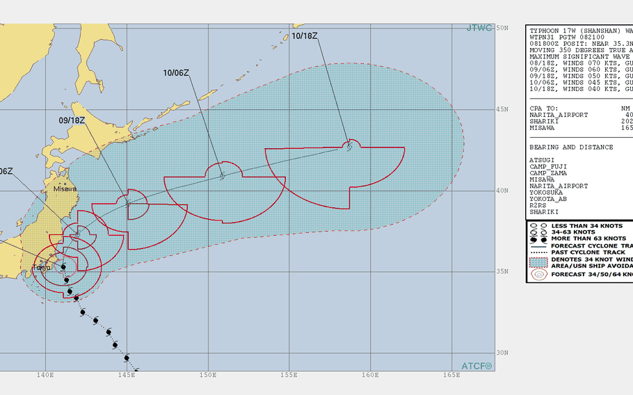
Shanshan continues clinging to Category 1-equivalent status, packing 75-mph sustained winds and 92-mph gusts as it continues north at 12 mph. This is the final report on Typhoon Shanshan.
5:45 a.m. Thursday, Aug. 9, Japan time: Closest point of approach by Typhoon Shanshan to U.S. bases in the Kanto Plain has come and gone. Now it's a matter of how quickly it makes its move north and east away from the Tokyo area.
At 3 a.m., Shanshan was 79 miles east of Yokosuka Naval Base, moving north at 9 mph, holding steady at 81-mph sustained winds and 98-mph gusts at center.
Shanshan is forecast to curve northeast as Thursday wears on, gradually weakening as it exits the Tokyo area.
It should remain somewhat windy in the Yokosuka area, winds out of the southwest between 29 and 35 mph sustained and gusts up to 46. But sunshine should return, and it should not be nearly as hot as it has been, thank goodness.
Fleet Activities Yokosuka remains in Tropical Cyclone Condition of Readiness 1. Most facilities remain closed and reporting for duty is delayed until two hours after the all clear is issued, sometime later Thursday morning.
Camp Zama, Yokota Air Base and Naval Air Facility Atsugi remain in TCCOR Storm Watch; again, the all clear should be directed later Thursday morning. Yokota's 374th Airlift Wing has authorized delayed reporting for duty until 10 a.m.
11:30 p.m. Wednesday, Aug. 8, Japan time: Shanshan is barely clinging to Category 1-equivalent typhoon status. It's weakening as it reaches the Tokyo-Kanto Plain area with its forecast destructive wind bands looking like they're remain offshore, according to the Joint Typhoon Warning Center's latest forecast track.
At 9 p.m., Shanshan was 106 miles east-southeast of Yokosuka Naval Base, headed north-northwest at 8 mph, packing 81-mph sustained winds and 98-mph gusts at center.
If Shanshan continues moving as forecast, it's due to pass 92 miles east of Yokosuka and 110 miles east of Camp Zama, Naval Air Facility Atsugi and Yokota Air Base between 2 and 4 a.m. Thursday.
But destructive winds of 58 mph or greater only extend 63 miles southwest of center and 52 miles northwest of center. It's possible Yokosuka could be spared much of Shanshan's inner fury.
Zama, Atsugi and Yokota remain in Tropical Cyclone Condition of Readiness Storm Watch, while Fleet Activities Yokosuka remains in TCCOR 1.
A high wind warning remains in effect for Yokosuka and its properties until 6 p.m. Thursday. Yokosuka's weather forecast calls for peak winds between 46- and 52-mph sustained and 69-mph gusts overnight Wednesday until dawn Thursday, gradually diminishing as the day wears on and Shanshan vacates the area.
6 p.m. Wednesday, Aug. 9, Japan time: Typhoon Shanshan's forward speed has slowed a bit. Closest point of approach to U.S. bases in the Kanto Plain is pushed back to just before dawn Thursday, according to the Joint Typhoon Warning Center's latest forecast track.
Yokota Air Base, Camp Zama and Naval Air Facility Atsugi remain in Tropical Cyclone Condition of Readiness Storm Watch. Fleet Activities Yokosuka is still in TCCOR 1.
At 3 p.m., Shanshan was 138 miles southeast of Yokosuka, headed northwest at 7 mph and holding steady at 92-mph sustained winds and 115-mph gusts at center.
Shanshan is forecast to start arcing north, then northeast as dawn turns to morning Thursday. It's due to pass 67 miles east of Yokosuka and 83 miles east of Zama, Atsugi and Yokota between 4 and 6 a.m., still packing 86-mph sustained winds and 104-mph gusts at center.
A heavy wind warning remains in effect at Yokota, along with a delay in reporting for duty until 10 a.m. Thursday, according to Yokota's official Facebook page.
5 p.m. Wednesday, Aug. 9, Japan time: Naval Air Facility Atsugi, Camp Zama and Yokota Air Base have entered Tropical Cyclone Condition of Readiness Storm Watch. Destructive winds of 58 mph or greater are no longer forecast to occur at each locale.
A heavy wind warning remains in effect, however, for Yokota, until 9 a.m. Thursday, according to Yokota's official Facebook page.
And the 374th Airlift Wing has authorized delay in reporting for duty until 10 a.m. Thursday. Strongest winds are forecast for between 3 and 9 a.m.; the wing recommends restricting travel to emergencies only between those hours.
Fleet Activities Yokosuka remains in TCCOR 1. Sustained winds between 46 and 52 mph and 69-mph gusts are forecast to begin after midnight.
11:45 a.m. Wednesday, Aug. 9, Japan time: Once more, it appears as if U.S. bases in the Kanto Plain might be spared Typhoon Shanshan's full wrath if Shanshan remains on its Joint Typhoon Warning Center's latest forecast track.
At 9 a.m., Shanshan was 177 miles southeast of Yokosuka Naval Base, headed north-northwest at 12 mph, packing 92-mph sustained winds and 115-mph gusts at center.
If Shanshan continues moving as forecast, it should weaken slightly, to 86-mph sustained winds and 104-mph gusts at center as it rumbles past the Tokyo-Kanto Plain area overnight Wednesday into Thursday.
Shanshan is forecast to pass 63 miles east of Yokosuka and 80 miles east of Camp Zama, Naval Air Facility Atsugi and Yokota Air Base between 2 and 4 a.m. Thursday.
Fleet Activities Yokosuka remains in Tropical Cyclone Condition of Readiness 1. Winds should pick up between 40- and 46-mph sustained with 58-mph gusts in the early evening, increasing to 46- to 52-mph sustained and 69-mph gusts overnight into Thursday, decreasing gradually as the day wears on, according to Yokosuka's weather portal.
Atsugi, Zama and Yokota remain in TCCOR 2. Depending on Shanshan's track, TCCOR can go one of two ways: it can be upgraded to TCCOR 1 if Shanshan moves closer, or those three bases could see TCCOR Storm Watch if the worst of Shanshan remains off shore.
Time to prepare for the storm is just about done. Get your safe on, Tokyo!
11 a.m. Wednesday, Aug. 8, Japan time: Fleet Activities Yokosuka has set a Tropical Cyclone Condition of Readiness 1 in advance of Typhoon Shanshan’s forecast arrival Wednesday evening. Destructive winds of 58 mph or greater are anticipated within 12 hours.
Naval Air Facility Atsugi, Camp Zama and Yokota Air Base have each set TCCOR 2. Destructive winds of 58 mph or greater are anticipated within 24 hours.
6 a.m. Wednesday, Aug. 8, Japan time: Closer, ever closer, Typhoon Shanshan is coming toward the Tokyo-Kanto Plain area, bringing with it possible destructive winds in a matter of hours to U.S. bases there.
At 5:30 a.m., Shanshan was 236 miles southeast of Tokyo, rumbling northwest at 9 mph and holding steady at 98-mph sustained winds and 121-mph gusts.
Fleet Activities Yokosuka and its properties remain in Tropical Cyclone Condition of Readiness 2; expect an upgrade to TCCOR 1 any time now. Naval Air Facility Atsugi, Yokota Air Base and Camp Zama remain in TCCOR 3; those should get upgraded as well.
If Shanshan remains on its present course, it's forecast to pass 60 miles east of Yokosuka Naval Base and 80 miles east of Yokota, Zama and Atsugi between 4 and 5 a.m. Thursday, still packing 81-mph sustained winds and 98-mph gusts.
Model guidance appears to be in tight agreement on an approach to Tokyo, followed by a sharp right curve northeast away from Japan's main islands over the next few days.
Though the worst winds appear to be confined to the eastern quadrants, U.S. bases appear to be on the edge of Shanshan's western 50-knot (58-mph) wind band. Just a question of how strong Shanshan remains as it approaches. Stay tuned.
Midnight Tuesday, Aug. 7, Japan time: Brace yourselves, Kanto Plain and Tokyo. Looks like a healthy dose of 58-mph winds or greater from Typhoon Shanshan may be on the way, if the Joint Typhoon Warning Center's latest forecast track is an indicator.
At 11:45 p.m., Shanshan was 320 miles southeast of Tokyo, headed northwest at 12 mph and had weakened slightly, to 98-mph sustained winds and 121-mph gusts at center, Category 2-equivalent strength.
If Shanshan remains on present course, it's due to diminish some more, remaining a Category 1-equivalent storm, 81-mph sustained winds and 98-mph gusts as it roars past Tokyo.
And U.S. bases appear as if they might be just inside Shanshan's 50-knot (58-mph) wind band, with upgrade to Tropical Cyclone Condition of Readiness 1 possible.
Currently, Yokota Air Base, Naval Air Facility Atsugi and Camp Zama remain in TCCOR 3, while Fleet Activities Yokosuka and its properties are in TCCOR 2. Expect those to be upgraded as night turns to dawn Wednesday.
Shanshan is due to pass 64 miles east of Yokosuka and 80 miles east of Zama, Atsugi and Yokota between 11 p.m. and midnight Wednesday.
Model guidance has come into much better agreement, with there only being about a 60-mile spread among model solutions.
Best to finish preparing cometh the dawn, brace for the worst and hope for the best. Get your safe on, Tokyo!
8:30 p.m. Tuesday, Aug. 7, Japan time: Fleet Activities Yokosuka has set Tropical Cyclone Condition of Readiness 2. Destructive winds of 58 mph or greater are anticipated within 24 hours.
6 p.m. Tuesday, Aug. 7, Japan time: And just like that, Typhoon Shanshan has re-intensified into a Category 2-equlvalent storm.
And it could remain at least a severe tropical storm, if not a Category 1-equivalent, when it approaches the Tokyo area by Thursday morning, if the latest Joint Typhoon Warning Center forecast holds.
At 5:30 p.m., Shanshan was 385 miles southeast of Tokyo, headed north-northwest at 11 mph and had strengthened to 104-mph sustained winds and 127-mph gusts -- a 23-mph increase in sustained winds and 29-mph increase in gusts over a six-hour period.
If Shanshan remains on its present heading, it's forecast to weaken gradually as it presses north, diminishing to 69-mph sustained winds and 86-mph gusts as it starts curving northeast, after closest point of approach to U.S. bases on the Kanto Plain.
Shanshan is forecast to pass 84 miles east of Yokosuka Naval Base and 100 miles east of Camp Zama, Naval Air Facility Atsugi and Yokota Air Base between 11 p.m. Wednesday and 2 a.m. Thursday.
Destructive winds are forecast to extend 58 miles from center in the southwest quadrant and 35 miles in the northwest. Still a possibility the Tokyo area might miss the most vicious winds, but it's still wait and see also.
U.S. bases in the Kanto Plain remain in Tropical Cyclone Condition of Readiness 3. Expect an upgrade sometime Tuesday evening or Wednesday morning.
12:20 p.m. Tuesday, Aug. 7, Japan time: U.S. bases on the Kanto Plain have entered Tropical Cyclone Condition of Readiness 3. Destructive winds of 58 mph or greater are possible within 48 hours.
Noon Tuesday, Aug. 7, Japan time: It's looking more and more like U.S. bases in the Kanto Plain might be spared the worst of Typhoon Shanshan.
And it's also looking more as if it will be a strong tropical storm as it roars past the Tokyo area late Wednesday and early Thursday, according to the Joint Typhoon Warning Center's latest forecast track.
At 9 a.m., Shanshan was 426 miles southeast of Yokosuka Naval Base, heading northwest at 12 mph, holding steady at 81-mph sustained winds and 98-mph gusts.
If Shanshan keeps on its present path, it's forecast to weaken to 63-mph sustained winds and 81-mph gusts as it heads toward the Tokyo area, then curves northeast as Thursday dawns.
Shanshan is forecast to pass 80 miles east of Yokosuka and 95 miles east of Camp Zama, Naval Air Facility Atsugi and Yokota Air Base between midnight Wednesday and 2 a.m. Thursday. Destructive 58-mph winds are forecast to extend between 40 and 46 miles west from storm's center.
Zama, Atsugi and Yokota remain in Tropical Cyclone Condition of Readiness 4 and Yokosuka in TCCOR 3 as of noon. Windfinder.com reports the Yokosuka-Yokohama areas could be limited to 47-mph sustained winds and 60-mph gusts early Thursday morning.
Model guidance remains divided, though the GFS and CMC ensembles have come into better agreement, at least on Shanshan heading toward Tokyo, then curving sharply northeast come Thursday.
11:30 p.m. Monday, Aug. 6, Japan time: Might Typhoon Shanshan not be a typhoon when it reaches the Tokyo area?
The Joint Typhoon Warning Center's latest forecast track indicates that may be a strong probability. Shanshan has picked up forward speed and has begun diminishing as it heads toward an early Thursday morning rendezvou with the Tokyo-Kanto Plain area.
At 11:15 p.m., Shanshan was 588 miles southeast of Tokyo, trucking north-northwest at 16 mph and had dropped off to 81-mph sustained winds and 98-mph gusts, barely hanging on to Category 1-equivalent status.
If Shanshan continues on its present course, it could weaken to tropical storm status, 69-mph sustained winds and 86-mph gusts. Better yet, Shanshan's 50-knot (58-mph) wind band could remain completely off shore, if the JTWC's newest track holds.
Shanshan is forecast to pass 84 miles east of Yokosuka Naval Base, 102 miles east of Camp Zama and Naval Air Facility Atsugi and 103 miles east of Yokota Air Base between 5 and 8 a.m. Thursday.
Shanshan's forecast 58-mph wind band only extends between 58 and 69 miles west of center. The math, for the moment, indicates possible good news for the Tokyo area.
Zama, Yokota and Atsugi remain in Tropical Cyclone Condition of Readiness 4, while Fleet Activities Yokosuka and its satellite properties remain in TCCOR 3. Whether those will be upgraded or revert to TCCOR Storm Watch is entirely up to Shanshan and its future forecast tracks.
6 p.m. Monday, Aug. 6, Japan time: Might Typhoon Shanshan pass just east enough of Tokyo that U.S. bases in the Kanto Plain might be spared those 58-mph destructive winds?
At least on paper, it seems possible. According to the Joint Typhoon Warning Center, Shanshan is forecast to pass 87 miles east of Yokosuka Naval Base at 4 a.m. Thursday, while its 58-mph wind bands stretch between 69 and 74 miles west of center.
Just enough to miss? Well, hold the phone; it's still hard to say exactly at this point.
There remains a vast spread, 414 miles, among model solutions, So Shanshan could track right over Tokyo; it could pass well east of the world's most heavily populated city. Time will tell.
Yokosuka has set Tropical Cyclone Condition of Readiness 3. Its official Facebook page states destructive winds are forecast to begin at 3 a.m. Thursday. All other U.S. bases in the Kanto Plain remain in TCCOR 4; expect that to change early Tuesday morning.
At 5:45 p.m., Shanshan was 680 miles south-southeast of Tokyo, headed north-northwest at 12 mph and holding steady at 92-mph sustained winds and 115-mph gusts at center.
If it remains on its current course, Shanshan is forecast to pass 87 miles east of Yokosuka, 106 miles east of Camp Zama and Naval Air Facility Atsugi and 110 miles east of Yokota Air Base between 4 and 6 a.m. Thursday, a bit earlier than previously forecast.
It will still be packing 81-mph sustained winds and 98-mph gusts, but that's at storm's at center.
And that all depends on which model Shanshan follows. The GFS and CMC ensembles have come into sliightly better agreement, but they're still a bit apart. Stay tuned, y'all.
Noon Monday, Aug. 6, Japan time: U.S. bases in the Kanto Plain are all in Tropical Cyclone Condition of Readness 4. Destructive winds of 58 mph or greater are possible within 72 hours.
Typhoon Shanshan has peaked at 92-mph sustained winds and 115-mph gusts, according to the Joint Typhoon Warning Center's latest forecast track, and is expected to pass just east of Tokyo Thursday morning as Category 1-equivalent typhoon.
At 11:45 a.m., Shanshan was 736 miles south-southeast of Tokyo, moving north-northwest at 10 mph. If Shanshan continues on its present course, it will maintain 75-mph sustained winds and 92-mph gusts as it rumbles just offshore of the Chiba Peninsula.
It's due to pass 72 miles east of Yokosuka Naval Base, 90 miles east of Camp Zama and Naval Air Facility Atsugi and 92 miles east of Yokota Air Base between 8 and 10 a.m. Thursday.
But yes, there remains quite a bit of uncertainty in the long-term forecast, about a 311-mile divide among model solutions. The GFS ensemble continues to favor a track close to Tokyo, while the CMC ensemble has come into better agreement, but remains well offshore.
And there's another wild card in the mix. JTWC issued a tropical cyclone formation alert on disturbance 93W Invest early Monday morning. No question it's headed northeast; it's whether it becomes its own tropical cyclone or interacts and/or gets absorbed by Shanshan. Only time will tell. Stay tuned.
11:30 p.m. Sunday, Aug. 5, Japan time: Typhoon Shanshan has resumed a north-northwesterly direction and remains on course to pass just east of the Tokyo-Kanto Plain area at mid-day Thursday, according to the Joint Typhoon Warning Center's latest forecast track.
Naval Air Facility Atsugi becomes the latest to join the TCCOR Conga Line, having joined Yokota Air Base and Camp Zama in Tropical Cyclone Condition of Readiness 5. Fleet Activities Yokosuka remains in TCCOR 4. Expect all to be in TCCOR 4 by Monday morning.
At 11:15 p.m., Shanshan was 874 miles south-southeast of Tokyo, headed north-northwest at 12 mph and had intensified to 92-mph sustained winds and 115-mph gusts.
If Shanshan remains on its present course, it's due to peak at Category 2-equivalent strength, 98-mph sustained winds and 121-mph gusts at mid-morning Monday.
Shanshan is now forecast to curve northwest toward Tokyo late Wednesday, then curve sharply northeast overnight, passing 49 miles east of Yokosuka, 70 miles east of Zama and Atsugi and 74 miles east of Yokota between 10 a.m. and noon Thursday, packing 69-mph sustained winds and 86-mph gusts at center.
But there remains a vast spread among model solutions, a 437-mile spread, according to JTWC (paragraph 3B). The GFS ensemble depicts a track close to Tokyo with some outliers taking Shanshan further west, while the CMC ensemble favors a more easterly track, again with a couple of western outliers. Stay tuned. More should be known in a couple more days.
8 p.m. Sunday, Aug. 5, Japan time: Fleet Activities Yokosuka has set Tropical Cyclone Condition of Readiness 4 for Yokosuka Naval Base and its satellite properties. Destructive winds of 58 mph or greater are possible within 72 hours. Yokota Air Base and Camp Zama remain in TCCOR 5.
So, just how close will Typhoon Shanshan come to the Tokyo-Kanto Plain area?
This remains a critical time in the life of a young storm, when the storm continues to organize and consolidate and model solutions are still not quite in full agreement.
Model guidance at the moment suggests three distinct solutions: Right over Tokyo and the Kanto Plain, just off shore or well off shore.
The Joint Typhoon Warning Center's latest track favors a solution somewhere in the middle. The GFS ensemble favors the track close to Tokyo and the CMC ensemble the one well off shore.
For the moment, the best way to put it is ... the only thing certain is uncertainty.
At 8 p.m., Shanshan was 934 miles south-southeast of Tokyo, headed almost due north at 6 mph, holding steady at 86-mph sustained winds and 104-mph gusts. Typhoon-force winds extend 60 miles from center and tropical storm-force winds 200 miles, according to the National Weather Service on Guam.
If it remains on its current course, Shanshan is forecast to pass 70 miles east of Yokosuka, 90 miles east of Camp Zama and Naval Air Facility Atsugi and 94 miles east of Yokota between 9 and 11 a.m. Thursday, packing 63-mph sustained winds and 81-mph gusts at center.
More and more, it looks as if Misawa Air Base will be well out of harm's way; Shanshan is forecast to pass 229 miles east of Misawa at 7 a.m. Friday.
12:10 p.m. Sunday, Aug. 5, Japan time: U.S. Army Garrison Japan at Camp Zama and Yokota Air Base have each set Tropical Cyclone Condition of Readiness 5. Destructive winds of 58 mph or greater are possible within 96 hours.
Noon Sunday, Aug. 5, Japan time: Typhoon Shanshan remains on track for a mid-week visit to Tokyo as a tropical storm, and it appears it might swerve away from Misawa Air Base just in the nick of time, according to the Joint Typhoon Warning Center.
At 11:45 a.m., Shanshan was 978 miles south-southeast of Tokyo and 690 miles north-northeast of Guam, headed north-northwest at 7 mph, holding steady at 86-mph sustained winds and 104-mph gusts at center.
Typhoon-force winds extend 60 miles from center and tropical storm-force winds 200 miles south and 165 miles north of center, according to the National Weather Service on Guam.
If Shanshan remains on its current course, it's forecast to peak at 104-mph sustained winds and 127-mph gusts at mid-afternoon Monday, then rapidly weaken as it approaches the Tokyo-Kanto Plain area at mid-morning Thursday.
Shanshan is forecast to pass 61 miles east-southeast of Yokosuka Naval Base and 80 miles east of Camp Zama, Naval Air Facility Atsugi and Yokota Air Base between 8 and 10 a.m. Thursday, still packing 63-mph sustained winds and 81-mph gusts.
The JTWC track has held fairly steady for the past few updates, but there remains a spread among forecast models. The GFS ensemble pretty much mirrors the JTWC solution, while the CMC ensemble favors a more easterly track.
Misawa should be spared much of Shanshan's fury; it's due to pass 143 miles east of Misawa at 9 a.m. Friday, with 46-mph sustained winds and 58-mph gusts at center.
11:45 p.m. Saturday, Aug. 4, Japan time: The bad news: Typhoon Shanshan's forecast track continues edging closer to Tokyo with every passing update from the Joint Typhoon Warning Center.
The silver lining, albeit a small one, is Shanshan is forecast to weaken rapidly as it approaches Tokyo. It could lose its typhoon status but still be a strong tropical storm as it roars past.
At 11:30 p.m., Shanshan was 1,058 miles south-southeast of Tokyo and 625 miles northeast of Guam, headed north-northwest at 13 mph, packing 81-mph sustained winds and 98-mph gusts at center.
Tropical storm-force winds extend 190 miles south of center and 165 miles north, according to the National Weather Service on Guam.
If Shanshan continues on its present course, it's forecast to graze the east coast of Honshu between 9 p.m. Wednesday and 9 p.m. Thursday.
It's due to pass 61 miles east of Yokosuka Naval Base and 77 miles east of Yokota Air Base, Camp Zama and Naval Air Facility Atsugi between 1 and 3 a.m. Thursday, packing 69-mph sustained winds and 86-mph gusts at center.
No upgraded Tropical Cyclone Conditions of Readiness yet; expect that to happen sometime late Sunday or early Monday.
Model guidance remains mixed at this point, understandable because the storm is so young. GFS ensemble still suggests a track similar to JTWC's, while the CMC ensemble favors a track further offshore. There remains a vast spread, of more than 400 miles, among model solutions, JTWC reports.
6 p.m. Saturday, Aug. 4, Japan time: Tokyo and U.S. bases on the Kanto Plain just can't seem to buy a break.
In just a little under two days' time Shanshan has morphed into a Category 1-equivalent typhoon and is set to become the second tropical cyclone in two weeks to threaten the Tokyo-Kanto Plain area, according to the Joint Typhoon Warning Center.
At 6 p.m., Shanshan was 1,150 miles south-southeast of Tokyo and 575 miles northeast of Guam, headed north-northwest at 9 mph with 75-mph sustained winds and 92-mph gusts at center.
Tropical storm-force winds extend 200 miles south of center and 90 miles north, according to the National Weather Service on Guam.
If Shanshan continues on its present course, it's forecast to peak at 110-mph sustained winds and 132-mph gusts at mid-afternoon Monday, still well to Tokyo's south.
Shanshan is due to curve northwest and skim the Tokyo-Kanto Plain area, passing 92 miles east of Yokosuka Naval Base, 110 miles east of Camp Zama and Naval Air Facility Atsugi and 108 miles east of Yokota Air Base between 3 and 5 a.m. Wednesday.
It should remain a Category 1-equivalent typhoon as it roars past Tokyo, with the aforementioned bases setting right at the edge of Shanshan's 50-knot (58-mph) wind bands. Thus, it's quite possible for Yokosuka, Yokota, Zama and Atsugi to get destructive winds early Wednesday morning.
U.S. bases in the Kanto Plain remain in Tropical Cyclone Condition of Readiness All Clear. That could change as soon as early Sunday morning.
It's also possible for Misawa Air Base, way up in northeast Honshu, to also get some effects from Shanshan. How close it passes to Misawa remains to be seen.
And given how young Shanshan is, there remains a vast spread, about 290 miles, among model solutions 72 hours out, or right around the time Shanshan is approaching the Tokyo area.
Model guidance depicts tracks as far west as central Honshu to as far east as well offshore. The GFS ensemble favors a track just east of the Kanto Plain, the CMC ensemble much further offshore.
Shanshan could become the second tropical cyclone to threaten the Tokyo-Kanto Plain area, on the heels of Jongdari two weeks ago.
Midnight Friday, Aug. 3, Japan time: The news is starting to worsen for the Tokyo area.
The latest Joint Typhoon Warning Center forecast track shows Tropical Storm Shanshan edging closer to the Kanto Plain by late evening Wednesday.
Still, it's not that bad -- yet. It could worsen still.
At 11:30 p.m., Shanshan was 1,337 miles south-southeast of Tokyo. It had just started to pick up forward speed, moving northwest at 8 mph, and had intensified to 52-mph sustained winds and 63-mph gusts.
If Shanshan remains on its present heading, it's forecast to pass 178 miles east of Yokosuka Naval Base -- 165 miles closer than previously reported -- at 9 p.m. Wednesday, packing 86-mph sustained winds and 104-mph gusts.
But that's at storm's center. Shanshan's forecast 64-knot (75-mph) and 50-knot (58-mph) wind bands are expected to remain well off-shore ... at least for the moment.
Model guidance remains spread about -- about a 230-mile spread in solutions three days out, and much more vast, about a 1,250-mile solution spread five days out, according to JTWC.
The GFS ensemble depicts a track close to the Kanto Plain, while the CMC ensemble shows a track much further off shore.
But note all the different solutions surrounding the thick, dark line in each ensemble. Shanshan is in its relative infancy. Much can change -- for the worse or for the better -- for the Tokyo area in the coming days. Stay tuned.
7 p.m. Friday, Aug. 3, Japan time: Shanshan spawned overnight Thursday and has strengthened quickly into a tropical storm northeast of Guam. Its initial Joint Typhoon Warning Center forecast track takes Shanshan north and east of the Marianas Islands and the Tokyo area.
At 3 p.m., Shanshan was 495 miles northeast of Guam and was quasi-stationary, packing 40 mph sustained winds and 52 mph gusts. Shanshan is due to turn north and peak at 92-mph sustained winds and 115 mph gusts at mid-afternoon Monday.
For the moment, Shanshan doesn’t appear to be a threat to either the Marianas islands or the Tokyo area. JTWC projects Shanshan to pass 357 miles northeast of Saipan at 11 p.m. Friday, then 343 miles east of Yokosuka Naval Base, Japan, at 7 a.m. Tuesday.
Model guidance appears mixed at the moment, with the GFS ensemble more or less mirroring the JTWC track, while the CMC ensemble depicts a track further east of the Tokyo area. Stay tuned.
