(Joint Typhoon Warning Center)
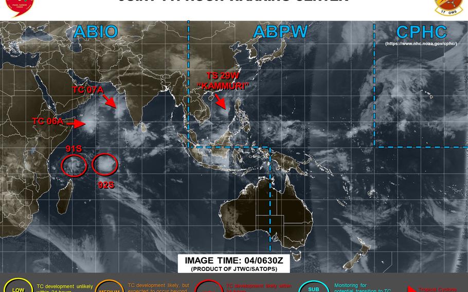
3:30 p.m. Wednesday, Dec. 4, Philippines time: All tropical cyclone warning signals have been lifted for the Philippines, according to the national weather authority PAGASA.Kammuri has also been downgraded to a tropical storm by the Joint Typhoon Warning Center. It continues moving west-northwest and is due to turn southwest and dissipate by the weekend due to a cold northeastery surge flow. But as Kammuri moves away, heavy seas remain possible for southern and central Luzon through the rest of the day, perhaps beyond, PAGASA reports. This is Storm Tracker's final report on Kammuri.11 p.m. Tuesday, Dec. 3, Philippines time: After a destructive swath across the central Philippines, Typhoon Kammuri has emerged back over water, through the Mindoro Strait into the South China Sea, and tropical cyclone warning signals continue gradually being lifted as Kammuri moves west. At 8 p.m., Kammuri was 114 miles south-southwest of Metro Manila, moving west-northwest at 13 mph packing 92-mph sustained winds and 115-mph gusts at center, Category 2-equivalent intensity. Its wind field remains fast, about 450 miles across the northern quadrants, but should become less pronounced as it moves away from land.Tropical Cyclone Warning Signal 3 remains raised over limited portions of Mindoro and southern and western Luzon, according to the national weather authority PAGASA, which refers to Kammuri as Tisoy. Closest points of approach to Manila, Clark International Airport and Subic Bay Free Port have come and gone. Kammuri is forecast to keep moving west-northwest, weakening as it goes, then get shoved southwest by a strong, cold northeasterly surge flow and dissipate by the weekend.5 p.m. Tuesday, Dec. 3, Philippines time: Typhoon Kammuri continues to weaken slightly as it makes its way across the central Philippines. But it remains a powerful Category 2-equivalent cyclone as it readies to re-emerge over water in the South China Sea.More than 200,000 were evacuated in advance of Kammuri, airports and seaports were closed and scores of flights and ferries canceled or shut down, stranding thousands of passengers, and dozens of schools were closed in the area of the cyclone, media outlets reported.Tropical Cyclone Warning Signal 3 remains raised for parts of southern and western Luzon and TCWS 2 for parts of western Visayas, according to the national weather authority PAGASA, which calls the storm Tisoy. At 2 p.m., Kammuri was 98 miles south of Metro Manila, headed west-northwest at 18 mph, still packing 98-mph sustained winds and 121-mph gusts at center. If Kammuri remains on its present heading, it should head into the South China Sea and track west-northwest, gradually weakening as it moves away from Luzon, then curve southwest and dissipate by the weekend.10:45 p.m. Monday, Dec. 2, Philippines time: Wow. Just wow. Kammuri has really dialed it up a notch or three as it makes its way west, about to make landfall north of Samar Island, having reached Category 4-equivalent intensity. Once it roars ashore, it'll be a battle between the frictional effects of land and the warmth of the Philippines' inland seas. Joint Typhoon Warning Center projects Kammuri to remain a violent storm as it crosses Visayas and southern Luzon overnight Monday into Tuesday. At 8 p.m., Kammuri, named Tisoy by the national weather authority PAGASA, was 271 miles east-southeast of Metro Manila, traveling west at 11 mph and had strengthened to 132-mph sustained winds and 161-mph gusts. A big, nasty beast, this one is. Tropical Cyclone Warning Signal 3 remains raised for vast portions of southern Luzon and Visayas, PAGASA reports. If Kammuri remains on its present heading, it's forecast to turn west-northwest, passing 70 miles south-southwest of Manila and Subic Bay Free Port and 104 miles south of Clark International Airport between 6 and 11 p.m. Tuesday. From there, JTWC projects Kammuri to remain a powerful Category 1-equivalent storm as it re-emerges over water in the South China Sea before curving southwest and dissipating by the weekend.4:15 p.m. Monday, Dec. 2, Philippines time: Tropical Cyclone Warning Signal 3 has been raised for portions of southern Luzon and Visayas in advance of Typhoon Kammuri's forecast arrival Monday evening into Tuesday morning, according to the national weather authority PAGASA. This is a bad one, campers. Kammuri strengthened rapidly in the last few hours, reaching Category 3-equivalent intensity, and could border on Category 4 as it approaches Visayas, according to the Joint Typhoon Warning Center. Kammuri's destructive wind bands stretch as much as 180 to 200 miles in diameter, JTWC reports. Local forecasts call for between 400 to 500 millimeters, almost two feet, of rain in the coming hours as Kammuri barrels through the area. Beware of flooding and landslides, particularly in low-lying areas; if you can get to higher ground, do so while there's time. At 2 p.m., Kammuri was 328 miles east-southeast of Metro Manila, moving west at 11 mph packing 121-mph sustained winds and 150-mph gusts at center, JTWC reports. Kammuri could peak at 127-mph sustained and 155-mph gusts as it roars ashore. JTWC projects Kammuri to pass 71 miles south of Metro Manila, 69 miles south of Subic Bay Free Port and 104 miles south of Clark Free Economic Zone between 5 and 9 p.m. Tuesday, still packing a wicked punch, 110-mph sustained winds and 132-mph gusts, JTWC forecasts. Long term, Kammuri is forecast to remain a powerful Category 1 or 2 equivalent cyclone even after re-emerging over open water in the South China Sea, before curving southwest and dissipating by the weekend.4:15 p.m. Sunday, Dec. 1, Philippines time: Tropical Cyclone Warning Signal 2 remains raised for northern and eastern Samar in Visayas and in portions of southern Luzon and TCWS 1 elsewhere in advance of Typhoon Kammuri, according to the Philippines national weather authority PAGASA. At 2 p.m., Kammuri, called Tisoy by PAGASA, was 593 miles east of Metro Manila, tracking west-southwest at 16 mph and packing 75-mph sustained winds and 92-mph gusts. Its wind field is vast, though Kammuri's destructive wind bands seem confined close to center. Typhoon-force winds extend up to 35 miles of center, and tropical storm-force winds up to 160 miles north and 100 south, according to the National Weather Service on Guam. For now, Kammuri remains a Category 1-equivalent storm. But if it continues on its present heading, it's forecast to peak as a Category 3-equivalent cyclone, 115-mph sustained winds and 144-mph gusts, at mid-afternoon Monday before ramming ashore near Samar early Tuesday morning. JTWC projects Kammuri to weaken as it interacts with land, but still be packing 92-mph sustained winds and 115-mph gusts as it passes 46 miles south of Manila and 50 south of Subic Bay Free Port between 3 and 8 p.m. Tuesday. Long term, JTWC forecasts Kammuri to emerge back over water in the South China Sea later Tuesday, curve southwest and die out later in the week.6 p.m. Saturday, Nov. 30, Philippines time: Typhoon Kammuri at 4 p.m. entered the Philippines area of responsibility and has been named Tisoy by the national weather authority PAGASA. Tropical Cyclone Warning Signal 1 has been issued for areas of eastern Visayas, PAGASA reports. Kammuri has weakened slightly as it continues tracking west-southwest. Joint Typhoon Warning Center projects Kammuri to make a straight run west and come ashore late Monday through Visayas and pass just south of Manila late Tuesday afternoon. At 5 p.m., Kammuri was 928 miles east of Metro Manila, 675 miles west of Guam and 1,006 miles south-southeast of Kadena Air Base, Okinawa, moving west-southwest at 11 mph, packing 81-mph sustained winds and 98-mph gusts. If it stays on its present heading, Kammuri is forecast to head west, peak at 121-mph sustained winds and 150-mph gusts, Category 3-equivalent cyclone, at mid-afternoon Monday before making landfall over the eastern Visayas. Kammuri is forecast to weaken slightly, to 98-mph sustained winds and 121-mph gusts, as it interacts with land and pass 49 miles south of Manila and 46 miles south of Subic Bay Free Por between 7 and 11 p.m. Tuesday. Long term, Kammuri remains due to curve slightly northwest into the South China Sea. Model track guidance and the GFS and CMC forecast ensembles then show a track southwest, with some outliers among the solutions.7 p.m. Friday, Nov. 29, Philippines time: Typhoon Kammuri has strengthened slightly and has begun its journey west toward the Philippines. It's forecast to make landfall as a Category 3-equivalent typhoon, maybe less, at mid-afternoon Tuesday. At 5 p.m., Kammuri was 1,088 miles east of Manila and 505 miles west of Guam, headed west-northwest at 7 mph and had strengthened to 86-mph sustained winds and 104-mph gusts. Typhoon-force winds extend up to 35 miles from center and tropical storm-force winds 145 miles, according to the National Weather Service on Guam. If Kammuri remains on its present heading, it's forecast to skim Samar in Visayas early Tuesday as a Category 3-equivalent typhoon, 121-mph sustained winds and 150-mph gusts, as it comes ashore. As it interacts with land, Kammuri is due to weaken slightly, passing 8 miles south of Metro Manila and 13 miles south of Subic Bay Free Port between 9 p.m. Tuesday and 1 a.m. Wednesday, still packing 104-mph sustained winds and 127-mph gusts. Long term, Kammuri is forecast to pass north of Palawan into the South China Sea overnight Wednesday into Thursday, still packing Category 1-equivalent winds.Model track guidance and the GFS and CMC ensembles generally agree with the JTWC track, and long term show Kammuri turning southwest. It's wait and see what happens in the long term.12:30 p.m. Friday, Nov. 29, Philippines time: Typhoon Kammuri has weakened slightly as it has finished its northern journey and begun curving west toward the Philippines. But the Joint Typhoon Warning Center continues to forecast Kammuri as a vicious beast, coming ashore over the central Philippines as a Category 3-equivalent cyclone with a vast wind field, stretching more than 300 miles north near the Babuyan Islands. At 9 a.m., Kammuri was 1,147 miles east of Metro Manila, headed northwest at 5 mph and had weakened slightly, to 81-mph sustained winds and 98-mph gusts at center. Typhoon-force winds stretch up to 35 miles from center and tropical storm-force winds up to 145 miles, according to the U.S. National Weather Service on Guam. If Kammuri remains on its present heading, it's due to peak at 121-mph sustained winds and 150-mph gusts at mid-afternoon Monday and maintain that strength as it reaches Samar in the Visayas portion of the Philippines the next day. JTWC projects Kammuri to weaken as it interacts with land, but remain a powerful Category 2-equivalent typhoon as it crosses the Philippines. It's forecast to make a direct or near-direct hit on Manila and later the former Subic Bay Naval Station between 11 p.m. Tuesday and 3 a.m. Wednesday, packing 104-mph sustained winds and 127-mph gusts. Much can change over the course of five days. Something to make serious preparations for. Get your safe on!7:30 p.m. Thursday, Nov. 28, Guam time: Happy Thanksgiving from the Storm Tracker team.Typhoon Kammuri is forecast to peak at Category 5-equivalent super-typhoon status at mid-afternoon Sunday, but then weaken slightly as it heads for Visayas in central Philippines. The silver lining, if there is such a thing, is Kammuri is due to make landfall at Category 3-equivalent status. Still, the outlook is grim for the central Philippines the middle of next week. At 4 p.m., Kammuri was 1,166 miles southeast of Kadena Air Base, Okinawa, and 1,182 miles east of Metro Manila, headed west-northwest at 7 p.m. packing 86-mph sustained winds and 104-mph gusts. Typhoon-force winds extend 30 miles from center and tropical storm-force winds 150 miles northwest and 120 miles elsewhere, according to the National Weather Service on Guam. If Kammuri remains on its present heading, it's due to peak at 150-mph sustained winds and 184-mph gusts at 4 p.m. Sunday before gradually weakening as it heads toward land. Joint Typhoon Warning Center projects Kammuri to hit the eastern Visayas at 2 p.m. local time Tuesday, still packing 121-mph sustained winds and 150-mph gusts.12:45 p.m. Wednesday, Nov. 27, Guam time: The tropical storm warning has been canceled for Guam, Rota, Tinian and Saipan, the National Weather Service reported at 11 a.m. But Tropical Storm Kammuri continues intensifying as it heads west and leaves the Marianas behind. Kammuri is forecast to peak at 132-mph sustained winds and 161-mph gusts, Category 4-equivalent intensity, at mid-morning Sunday, well away from any land mass. At 10 a.m., Kammuri was 200 miles southwest of Guam and 325 miles southwest of Saipan, moving west-northwest at 20 mph packing 63-mph sustained winds and 81-mph gusts. Guam has resumed seasonal Tropical Cyclone Conditiion of Readiness 4, according to Guam Homeland Security and Office of Civil Defense's official Facebook page. Whether the Philippines is affected by Kammuri remains to be seen. Model track guidance and the GFS and CMC forecast ensembles remain jumbled. It remains a wait-and-see game.7 a.m. Wednesday, Nov. 27, Guam time: A tropical storm warning remains in effect for Guam, Rota, Tinian and Saipan as Tropical Storm Kammuri continues passing south and southwest of the main Marianas Islands. U.S. bases on Guam remain in Condition of Readiness 4, while GovGuam remains in COR 2, according to Guam Homeland Security/Office of Civil Defense. Naval Base Guam's official Facebook page says "Big Navy" is open for normal business operations. At 4 a.m., Kammuri was 160 miles south-southwest of Guam and 290 miles south-southwest of Saipan, moving west-northwest at 20 mph, maintaining sustained 46-mph winds and 58-mph gusts. Tropical storm-force winds extend up to 275 miles north of center and up to 70 miles south, according to the National Weather Service. Kammuri is forecast to continue moving generally west, away from the Marianas, before curving northwest and intensifying into a typhoon as early as Thursday, but well away from land masses. It remains to be seen whether the Philippines might be affected, though model track guidance suggests it's possible at some point next week. GFS and CMC ensembles remain unsettled. Still wait-and-see at this point.6:30 p.m. Tuesday, Nov. 26, Guam time: Kammuri has been upgraded to a tropical storm by the Joint Typhoon Warning Center. It remains forecast to skim just south of Guam overnight Tuesday into Wednesday morning, but as naught more than a tropical storm. It's what happens as it roams further west that may be cause for concern. At 4 p.m., Kammuri was 240 miles southeast of Guam and 305 miles south-southeast of Saipan, moving west-northwest at 16 mph, packing 40-mph sustained winds and 52-mph gusts at center, according to the National Weather Service and Joint Typhoon Warning Center. A tropical storm warning remains in effect for Guam, Rota, Tinian and Saipan. Defense Department on Guam remains in seasonal Tropical Cyclone Condition of Readiness 4, but Government of Guam has upgraded to COR 2, according to Andersen Air Force Base's and Joint Region Marianas official Facebook pages If Kammuri remains on its present heading, JTWC forecasts it to pass 145 miles south-southwest of Andersen Air Force Base at about 3 a.m. Wednesday, steadily intensifying as it moves west. And intensify rather mightily as it moves west of the Marianas, JTWC projects, reaching Category 4-equivalent intensity at mid-afternoon Sunday. Still well away from any land mass, but still a cause for concern.Model track guidance and the GFS and CMC ensembles each show generally west movement toward the Philippines, with plenty of outliers. Still early in the life of Kammuri. Stay tuned.9 a.m. Tuesday, Nov. 26, Guam time: First warning has been issued on the 29th numbered system of the northwest Pacific's tropical cyclone season. Tropical Depression 29W is forecast to reach tropical-storm status as it passes south of guam overnight Tuesday. At 7 a.m., 29W was 475 miles southeast of Guam, mosing west-northwest at 17 mph, according to the National Weather Service. A tropical storm warning has been issued for Guam, Tinian, Rota and Saipan. If it remains on its current heading, Joint Typhoon Warning Center projects 29W to pass 210 miles south-southwest of Andersen at 2 a.m. Wednesday, packing 40-mph sustained winds and 52-mph gusts.11 p.m. Monday, Nov. 25, Guam time: A tropical cyclone formation alert was issued on 94W Invest by the Joint Typhoon Warning Center at 7 p.m. local time. At 7 p.m., 94W was 736 miles east-southeast of Andersen Air Force base and moving west at 18 mph, with winds gusting to 25 mph. Though 94W's initial track takes it very close to Guam, development continues rather slowly, JTWC reports. Every chance it could develop into a tropical depression in the next day or so, or pass south of Guam as a tropical disturbance, as the National Weather Service reported earlier. Still wait-and-see. A gale warning and a small-craft advisory remain in effect for Guam until mid-day Tuesday, NWS reports.5:45 p.m. Monday, Nov. 25, Guam time: 94W Invest is still having a tough time organizing, and could most likely pass Guam Tuesday evening as a tropical disturbance, according to the National Weather Service.Model track guidance continues to generally agree on a straight run west toward the Philippines. The GFS and CMC ensembles best tracks sort of show the same, but with plenty of outliers among solutions. It could strengthen and become a numbered system as it moves west through the Philippine Sea. Still a wait-and-see game.4:30 p.m. Saturday, Nov. 23, Guam time: A new tropical disturbance, labeled 94W Invest, has formed south of Kwajalein. At mid-afternoon Saturday, it was 1,754 miles east-southeast of Andersen Air Force Base, Guam.
Model track guidance, the GFS and the CMC ensembles are inconclusive at the moment, but show possible development and west-northwest movement toward Guam by Tuesday or Wednesday.
Bottom line: It's still too early to tell what it might become of this disturbance, as well as how close to Guam it might come — if at all. Just something to keep an eye on.
