()
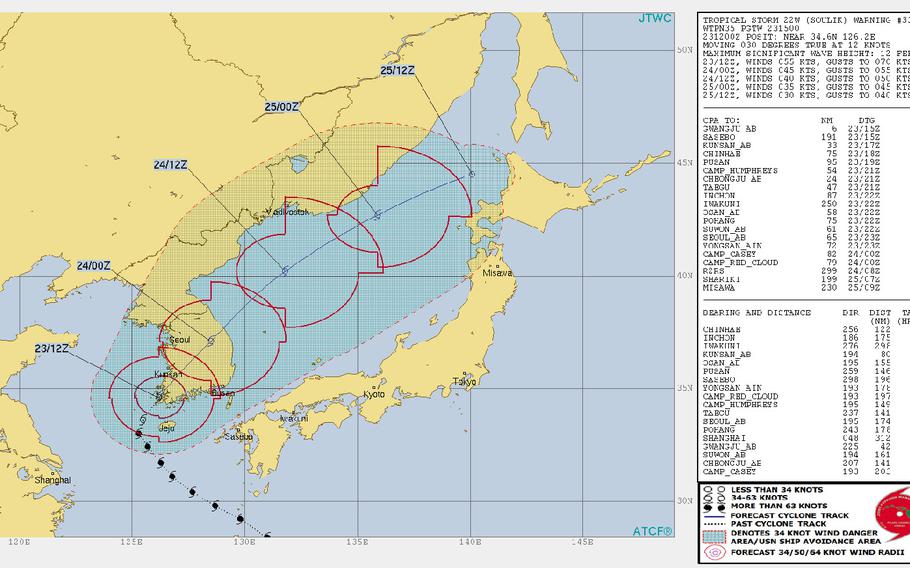
9 a.m. Friday, Aug. 24, Korea time: Tropical Storm Soulik continues weakening as it crosses the Korean peninsula. The shelter-in-place order has been rescinded at Kunsan Air Base, though non-essential facilities remained closed early Friday.
At Osan Air Base, the duty day begins at 11 a.m.
The all clear has been issued at Camp Humphreys, with facilities scheduled to start reopening at 9:30 a.m. This is the final report on Soulik.
1:45 a.m. Friday, Aug. 24, Korea time: Tropical Storm Soulik made landfall at mid-evening Thursday near Mokpo, along Korea’s southwest coast. It’s making its way through the central part of the peninsula, much further east of U.S. bases on Korea’s west coast than previously forecast, and toward the Sea of Japan.
At 9 p.m. Thursday, Soulik was 92 miles south-southwest of Kunsan Air Base, headed north-northeast at 14 mph and was holding steady at 63-mph sustained winds and 81-mph gusts.
If Soulik remains on its present course, it’s forecast to pass 38 miles southeast of Kunsan at 2 a.m. Friday, then 62 miles southeast of Camp Humphreys, 67 miles east of Osan Air Base and 83 miles east of Yongsan Garrison between 6 and 8 a.m. Friday, by which time it’s forecast to be packing 52-mph sustained winds and 63-mph gusts.
Kunsan remains on shelter-in-place order. All other bases have put word out to check with their official Facebook pages or their commanders’ access channels for updates on wind and road conditions and on reporting to work Friday.
6 p.m. Thursday, Aug. 23, Korea time: Soulik has been downgraded to a tropical storm by the Joint Typhoon Warning Center, but is still packing a nasty punch as it arcs toward U.S. bases along the west coast of South Korea.
A shelter in place order, removed temporarily by Kunsan Air Base, has been reinstated for 7 p.m. Thursday and will remain in place until Tropical Cyclone Condition of Readiness All Clear is directed. Kunsan remains in TCCOR 1 and has been directed for Camp Humphreys, while Osan Air Base remains in TCCOR 2.
At 3 p.m., Soulik was 170 miles south-southwest of Kunsan, moving north-northeast at 7 p.m., packing 69-mph sustained winds and 86-mph gusts at storm’s center.
If Soulik continues moving as forecast, it should come ashore around midnight around Mokpo, on Korea’s southwest coast, and pass 13 miles east of Kunsan, 36 miles east of Humphreys, 39 miles east of Osan and and 56 miles east of Yongsan Garrison between 3 and 8 a.m. Friday, diminishing to 63-mph sustained winds and 81-mph gusts as it moves inland.
Noon Thursday, Aug. 23, Korea time: Osan Air Base announced on its Facebook page that base functions will begin closing at 1 p.m. Thursday. Commissary and PX will shut down at 2 and base taxis will operate until 3 p.m.
No word yet about whether personnel should report to work on Friday at Osan or other U.S. bases on Korea’s west coast; it’s all about how quickly Typhoon Soulik vacates the area. All TCCORs remain the same for the moment; monitor your base’s Facebook pages for any changes.
At 9 a.m., Soulik was 212 miles south-southwest of Kunsan, headed north-northwest at 9 mph, barely holding on to Category 1-equivalent status, 75-mph sustained winds and 92-mph gusts. It’s forecast to be downgraded to a tropical storm as it passes Mokpo on Korea’s southwest corner by mid-evening Thursday.
It’s due to pass 19 miles west of Kunsan at 3 a.m. Friday, then 12 miles east of Osan, 7 miles east of Camp Humphreys and 25 miles east of Yongsan Garrison between 7 and 8 a.m. Friday as a tropical storm, 63-mph sustained winds and 81-mph gusts.
6 a.m. Thursday, Aug. 23, Korea time:Typhoon Soulik has begun arcing toward the Korean peninsula, weakening gradually as it goes. Kunsan Air Base remains in Tropical Cyclone Condition of Readiness 1, and Camp Humphreys and Osan Air Base in TCCOR 2.
Soulik remains on course to make a direct hit on Kunsan at 2 a.m. Friday, still packing 63-mph sustained winds and 81-mph gusts. Shelter in place procedures are currently in effect until TCCOR All Clear is directed. Sustained 58-mph winds are forecast starting at 11 a.m., with peak gusts of 80 mph and 4 to 6 inches of rain.
Camp Humphreys plans to release all non-essential personnel at noon. Garrison events for Thursday and Friday are canceled and most services will shutter starting at noon.
Osan plans to remain open on Thursday, though that could change depending on Soulik’s forecast track and strength of winds. Sustained winds of 40 mph are forecast for 4 p.m. Thursday to 3 p.m. Friday with maximum 63-mph gusts between 9 and 11 a.m. Friday.
If Soulik continues moving as forecast, it should pass 15 miles east of Camp Humphreys, 18 miles east of Osan and 29 miles east of Yongsan Garrison between 6 and 8 a.m. Friday, packing tropical storm-force winds, according to the Joint Typhoon Warning Center.
12:30 a.m. Thursday, Aug. 23, Korea time: Kunsan Air Base remains in Tropical Cyclone Condition of Readiness 1 in advance of a forecast direct hit by Typhoon Soulik, and could upgrade to TCCOR 1-C at any time when the onset of 40-mph sustained winds occurs. TCCOR 1-E could follow if 58-mph winds begin.
Meanwhile, Osan Air Base and Camp Humphreys remain in TCCOR 2. Soulik is now projected to make landfall sooner than previously forecast, and possibly pass east of Osan and Humphreys, instead of west.
At midnight, Soulik was 300 miles south of Kunsan and 345 miles south of Osan. Its forward speed had slowed; it was moving northwest at 8 mph; and it had weakened slightly, to 98-mph sustained winds and 121-mph gusts at center.
If it continues moving as forecast, Kunsan is expecting a direct hit at 2 a.m. Friday. Soulik is next forecast to pass 14 miles east of Humphreys, 16 east of Osan and 29 miles east of Yongsan Garrison between 6 and 8 a.m. Friday.
Kunsan continues to brace for the onset of 40-mph sustained winds at 4 a.m. Thursday, which meet TCCOR 1-C criteria, and destructive 58-mph winds starting at 11 a.m. Thursday, which meet TCCOR 1-E criteria. Kunsan is also forecasting between 4 to 6 inches of rain.
Also, effective 4 a.m. Thursday until TCCOR All Clear is directed, shelter-in-place procedures for Wolf Pack personnel are in effect. All non-typhoon response personnel are to shelter in their dormitory or other residence, according to Kunsan’s official Facebook page.
Osan is forecasting the onset of 40-mph sustained winds at 4 p.m. Thursday, continuing until 3 p.m. Friday with peak 63-mph gusts between 9 and 11 a.m. Friday, along with between 2 to 3 inches of rain.
6:30 p.m. Wednesday, Aug. 22, Korea time: Osan Air Base remains in Tropical Cyclone Condition of Readiness 2, Camp Humphreys set TCCOR 2 at 1 p.m. and Kunsan Air Base remains in TCCOR 1 as Typhoon Soulik continues its approach toward Korea’s west coast.
At 6 p.m., Soulik was 220 miles southwest of Sasebo Naval Base in southwestern Japan, 339 miles south of Kunsan and 391 miles south of Osan, moving northwest at 12 mph and had again diminished slightly, to 104-mph sustained winds and 127-mph gusts at center. Fleet Activities Sasebo directed TCCOR All Clear for Sasebo and its properties at 4 p.m.
Kunsan is bracing for the onset of 40-mph sustained winds at 4 a.m. Thursday, meeting TCCOR 1-C (caution) criteria, and destructive 58-mph sustained winds at 11 a.m. meeting TCCOR 1-E (emergency) criteria. Maximum gusts of 80 mph and 4 to 6 inches of rain are forecast.
Osan reports that despite being in TCCOR 2, the base is scheduled to be open on Thursday; that could change, depending on Soulik’s strength and forecast track. Osan is expecting 40-mph sustaind winds between 10 p.m. Thursday and 10 a.m. Friday, with gusts up to 75 mph between 11 p.m. Thursday and 4 a.m. Friday, along with 4 to 5 inches of rain.
Soulik is forecast to pass 28 miles west of Kunsan at 2 a.m. Friday, 15 miles west of Camp Humphreys and 11 miles west of Osan at 5 a.m. and 9 miles west of Yongsan Garrison and Camp Red Cloud between 8 and 10 a.m. Friday, diminishing rapidly as it makes its way inland.
11:45 a.m. Wednesday, Aug. 22, Korea time: A slight bit of good news for U.S. bases on Korea’s west coast: Soulik is forecast to weaken sufficiently that it may strike or pass by on Thursday as a tropical storm, instead of a typhoon.
But that probably won’t lessen the threat to Kunsan and Osan Air Bases and Camp Humphreys. Kunsan remains in Tropical Cyclone Condition of Readiness 1, while Osan set TCCOR 2 at mid-morning Wednesday and Humphreys remains in TCCOR 3.
At 11:30 a.m., Soulik was 385 miles south of Kunsan and 451 miles south of Osan, headed northwest at 13 mph and holding steady at 110-mph sustained winds and 132-mph gusts.
Soulik is forecast to arc north, then northeast, passing 42 miles west of Kunsan at 1 a.m. Friday, 31 miles west of Humphreys and 29 miles west of Osan at 6 a.m. and 17 miles west of Yongsan Garrison at 8 a.m., packing 63-mph sustained winds and 81-mph gusts as it passes Kunsan.
Expect Osan to upgrade to TCCOR 1 shortly. Kunsan sbould upgrade to TCCOR 1-C (caution) at around 1 a.m. Thursday, when the onset of 40-mph sustained winds is forecast, then to TCCOR 1-E (emergency) at about 7 a.m., when the onset of destructive 58-mph winds is projected.
6 a.m. Wednesday, Aug. 22, Korea time: Kunsan Air Base has directed Tropical Cyclone Condition of Readiness 1 in anticipation of Typhoon Soulik’s arrival. Destructive winds of 58 mph or greater are anticipated within 12 hours.
Kunsan, on Korea’s southwest coast, announced on its official Facebook page that 40-mph sustained winds are expected at 1 a.m. Thursday, increasing to destructive 58-mph sustained winds at 7 a.m.
At 5:45 a.m., Soulik was 443 miles south-southeast of Kunsan and 477 miles south of Osan Air Base, moving northwest at 13 mph, holding steady at 110-mph sustained winds and 132-mph gusts at center.
Soulik is forecast to make a wide arc around Korea’s southwest coast, passing 27 miles west of Kunsan at 7 p.m. Thursday, still packing 75-mph sustained winds and 92-mph gusts at center.
It should then diminish as Soulik makes its way inland, passing 15 miles west of Osan at 1 a.m. Friday, then 7 miles west of Yongsan Garrison at 3 a.m. Friday, still packing 58 mph sustained winds and 75-mph gusts.
12:30 a.m. Wednesday, Aug. 22, Korea time: Closest point of approach by Typhoon Soulik to Okinawa has come and gone. Soulik remains on a northwest track that is now taking it just west of U.S. bases on Korea’s southwest coast.
Kunsan Air Base remains in Tropical Cyclone Condition of Readiness 2, while Sasebo Naval Base in southwestern Japan – which should remain well out of harm’s way – remains in TCCOR Storm Watch.
At midnight Tuesday, Soulik was 506 miles south-southeast of Kunsan and 541 miles south-southeast of Osan Air Base, headed northwest at 15 mph and had weakened slightly, to 110-mph sustained winds and 132-mph gusts at center. Soulik is forecast to pass 190 miles west-southwest of Sasebo at mid-afternoon Tuesday.
Then, Soulik is forecast to arc north, barely skimming the southwest coast of Korea and maintaining 81-mph sustained winds and 98-mph gusts as it passes 34 miles west of Kunsan at 7 p.m. Thursday. Onset of 40-mph sustained winds is forecast for 11 p.m. Wednesday and destructive 58-mph sustained winds at 8 a.m. Thursday.
Soulik is forecast to gradually weaken as it interacts with land and curves inland, passing 30 miles west of Osan at midnight Thursday as a strong tropical storm, packing 63-mph sustained winds and 81-mph gusts.
Soulik should then zoom north across the DMZ through North Korea and into Manchuria, where it’s forecast to die out on the weekend.
6:30 p.m. Tuesday, Aug. 21, Korea time: Kunsan Air Base on Korea’s southwest coast has directed Tropical Cyclone Condition of Readiness 2 in advance of Typhoon Soulik. Destructive winds of 58 mph or greater are anticipated within 24 hours.
According to Kunsan’s official Facebook page, onset of 40-mph sustained winds is forecast for 11 p.m. Wednesday and destructive 58-mph sustained winds for 8 a.m. Thursday. Maximum gusts of 100 mph are forecast along with 4 to 6 inches of rain.
Further up the street at Osan Air Base, 40-mph sustained winds are forecast for 6 a.m. to midnight Thursday, destructive 58-mph sustained winds between 11 a.m. and 3 p.m. and maximum gusts of 74 mph between noon and 3 p.m. Elsewhere, Sasebo Naval Base remains in TCCOR Storm Watch.
At 6:15 p.m. Tuesday, Soulik was 247 miles northeast of Kadena Air Base, Okinawa, 575 miles south-southeast of Kunsan and 656 miles south-southeast of Osan, moving northwest at 15 mph and holding steady at 115-mph sustained winds and 144-mph gusts.
If Soulik remains on its current course, it should pass 225 miles northeast of Kadena at 9 p.m. Tuesday and 188 miles west-southwest of Sasebo at 4 p.m. Wednesday.
Soulik is then forecast to skim Korea’s west coast, maintaining 98-mph sustained winds and 121-mph gusts as it roars 20 miles west of Kunsan and Osan, 22 miles west of Camp Humphreys and 13 miles west of Yongsan Garrison between 4 p.m. and midnight Thursday.
11:40 a.m. Tuesday, Aug. 21, Korea time: With Typhoon Soulik forecast to pass well west, Fleet Activities Sasebo has directed Tropical Cyclone Condition of Readiness Storm Watch for Sasebo Naval Base and its satellite properties, according to CFAS’ Facebook page.
Meanwhile, Kunsan Air Base remains in TCCOR 3. It and all U.S. bases on South Korea’s west coast are bracing for typhoon-force winds as Soulik continues rumbling northwest toward a mid-morning Thursday rendezvous.
At 11:30 a.m., Soulik was 283 miles northeast of Kadena Air Base, Okinawa and 622 miles south-southeast of Kunsan, traveling northwest at 14 mph, holding steady at 115-mph sustained winds and 144-mph gusts at center.
Excepting a few forecast gusts and wind bands, Kadena and Sasebo remain safely out of harm’s way; Soulik is due to pass 225 miles northeast of Kadena at 9 p.m. Tuesday and 196 miles west-southwest of Sasebo at 1 p.m. Wednesday.
But Soulik is forecast to pack a major punch when it roars toward Korea’s southwest coast, still packing 86-mph sustained winds and 104-mph gusts as it passes just 7 miles west of Kunsan and Osan Air Bases, 8 miles west of Camp Humphreys and makes a near-direct hit on Yongsan Garrison between 1 and 9 p.m. Thursday.
It should rapidly weaken and pick up quick forward speed as it races through the peninsula, exiting into eastern Russia as a tropical depression.
Model guidance remains divided, with both the GFS and CMC ensembles mirroring the JTWC track, but with wide variations among model solutions.
11 p.m. Monday, Aug. 20, Korea time: Osan Air Base might brace itself for quite a bit of rainfall from Typhoon Soulik. The 51st Fighter Wing’s official Facebook page projects 4 to 5 inches of rain between 8 a.m. Wednesday and 8 a.m. Friday, along with 80-mph gusts at mid-afternoon Thursday.
Kunsan Air Base, meanwhile, remains in Tropical Cyclone Condition of Readiness 3, as it’s expecting a direct or near-direct hit early Thursday. Sasebo Naval Base in southwestern Japan also remains in TCCOR 3.
At 10:45 p.m., Soulik was 795 miles southeast of Kunsan and 865 miles south-southeast of Osan, moving west-northwest at 12 mph and holding steady at 115-mph sustained winds and 144-mph gusts.
Kadena Air Base on Okinawa remains out of harm’s way for now; Soulik is forecast to pass 220 miles northeast of Kadena at 9 p.m. Tuesday and 176 miles west-southwest of Sasebo at 6 p.m. Wednesday. Soulik is forecast to diminish slightly as it passes Sasebo, 104-mph sustained winds and 127-mph gusts at center.
Then comes the rendezvous with Korea’s southwest coast. Soulik is due to pass 8 miles west of Kunsan, 15 miles west of Camp Humphreys, 13 miles west of Osan and 9 miles west of Yongsan Garrison between 3 p.m. and 11 p.m. Thursday, rapidly weakening as it moves north.
Slight disparity remains in model guidance, with GFS favoring JTWC’s track and NAVGEM projecting one further east, through Daegu and into the Sea of Japan.
7 p.m. Monday, Aug. 20, Korea time: Typhoon Soulik is forecast to rake Osan Air Base with destructive 58-mph sustained winds between 8 a.m. and 3 p.m., according to the 51st Fighter Wing’s official Facebook.
Soulik has picked up forward speed and intensified slightly, and remains forecast to bypass Kadena Air Base, Okinawa, and Sasebo Naval Base in western Japan, but continues to put U.S. bases on Korea’s west coast in its sights.
At 6:30 p.m., Soulik was 860 miles southeast of Kunsan Air Base on Korea’s southwest coast and 930 miles southeast of Osan, traveling west-northwest at 11 mph packing 115-mph sustained winds and 144-mph gusts.
Soulik should spare Okinawa and Sasebo; the Joint Typhoon Warning Center projects Soulik to pass 220 miles northeast of Kadena at 8 p.m. Tuesday, then 159 miles west-southwest of Sasebo 22 hours later.
Soulik is forecast to weaken as it passes over Cheju Island, then skirt the southwest coast of the Korean peninsula, passing 7 miles west of Kunsan at 1 p.m. Thursday, packing 75-mph sustained winds and 92-mph gusts as it roars past.
Next is Osan, with Soulik projected to pass 21 miles west at 7 p.m. Thursday. Osan’s Facebook page projects 58-mph sustained winds and 81-mph gusts as Soulik moves north.
1 p.m. Monday, Aug. 20, Japan time: Fleet Activities Sasebo has directed Tropical Cyclone Condition of Readiness 3 for Sasebo Naval Base and its properties. Destructive winds of 58 mph or greater are possible within 48 hours. CFAS’ official Facebook page states that TCCORs are expected to be upgraded and they’ll maintain TCCOR 1 throughout Wednesday until Typhoon Soulik passes.
11:45 a.m. Monday, Aug. 20, Japan time: Kunsan and Osan Air Bases and Camp Humphreys might begin bracing themselves for a possible visit by Typhoon Soulik come Thursday morning, according to the Joint Typhoon Warning Center’s latest forecast track.
At 11:30 a.m., Soulik was 906 miles southeast of Kunsan, tracking west at 12 mph, packing 104-mph sustained winds and 127-mph gusts.
If it continues on its present course, it’s almost as if Soulik will make a tour of all U.S. bases on South Korea’s west coast – near-direct hits on Kunsan, Camp Humphreys, Osan and Yongsan Garrison between 9 a.m. and 3 p.m. Thursday. It’s forecast to remain a Category 1-equivalent typhoon as it moves north, 75-mph sustained winds and 92-mph gusts.
Though Soulik’s track has wobbled quite a bit the last few forecast periods, Okinawa and Sasebo Naval Base appear to be out of harm’s way for now. JTWC projects Soulik to pass 221 miles northeast of Kadena Air Base at 7 p.m. Tuesday and 158 miles west-southwest of Sasebo at 4 p.m. Wednesday.
6 a.m. Monday, Aug. 20, Japan/Korea time: Typhoon Soulik continues moving slowly northwest, and its latest forecast track takes it over the southwest coast of the Korean peninsula as a Category 1-equivalent typhoon, passing just east of U.S. bases on the west coast, according to the Joint Typhoon Warning Center.
At 3 a.m., Soulik was 689 miles southeast of Sasebo Naval Base, headed northwest at 9 mph and holding steady at 110-mph sustained winds and 132-mph gusts. Soulik remains forecast to peak at 115-mph sustained winds and 144-mph gusts as it passes 250 miles northeast of Kadena Air Base at 6 p.m. Tuesday.
Landfall over Korea is forecast for around midnight Wednesday or early morning Thursday, still packing 86-mph sustained winds and 104-mph gusts as it roars 30 miles east of Kunsan Air Base, 22 miles east of Osan Air Base and 84 miles west of Chinhae Naval Base between 2 and 9 a.m. Thursday.
11:30 p.m. Sunday, Aug. 19, Japan/Korea time: Typhoon Soulik’s forecast track has edged back east some, slightly further away from Okinawa, closer to Sasebo Naval Base and placing possible landfall more toward the middle of the Korean Peninsula’s south coast, according to the Joint Typhoon Warning Center.
At 11 p.m., Soulik had begun picking up forward speed and was 656 miles east of Kadena Air Base, 1,000 miles southeast of Kunsan Air Base, South Korea, and 748 miles southeast of Sasebo, headed west-northwest at 7 mph and had weakened slightly, to 110-mph sustained winds and 132-mph gusts at center.
The big question, as always, is will Soulik remain on its current course. If so, Soulik is due to strengthen slightly again, back to 115-mph sustained winds and 144-mph gusts as it passes 235 miles northeast of Kadena at 7 p.m. Tuesday.
A long, wide arc north should follow, with Soulik plowing ashore along Korea’s south coast at late evening Wednesday to early morning Thursday, still packing 92-mph sustained winds and 115-mph gusts as it makes landfall.
Soulik is forecast to pass 125 miles west of Sasebo, 68 miles west of Chinhae Naval Base, 51 miles east of Kunsan Air Base and 42 miles east of Osan Air Base between 4 p.m. Wednesday and 10 a.m. Thursday. It should diminish rapidly as it traverses Korea’s rough terrain, finally re-emerging over the East Sea late Thursday afternoon.
Model guidance remains mixed, with GFS preferring a track along Korea’s west coast and NAVGEM favoring a track closer to Sasebo and Chinhae. JTWC’s track splits the difference.
5:40 p.m. Sunday, Aug. 19, Japan/Korea time: Typhoon Soulik has slowed once again as it continues struggling to find any kind of forward speed. But its latest forecast track continues to put Korea’s southwest coast in its crosshairs for landfall late Wednesday evening, with Okinawa out of harm’s way for now.
At 5:25 p.m., Soulik was 690 miles east of Kadena Air Base, Okinawa, and 1,035 miles southeast of Kunsan Air Base, South Korea, crawling west-southwest at 5 mph, holding steady at 115-mph sustained winds and 144-mph gusts at center.
If Soulik keeps on its present path, it should pick up forward speed and head northwest, passing 223 miles northeast of Kadena at 7 p.m. Tuesday, with Kadena well outside of Soulik’s 34-knot wind band.
Sasebo Naval Base, Japan, might be spared full fury; Soulik is forecast to pass 150 miles west of Sasebo at 2 p.m. Wednesday, just outside Soulik’s 50-knot (58-mph) destructive wind band.
Following that, Soulik remains forecast to make a wide curve north, making landfall at about 9 to 10 p.m. Wednesday near Mokpo on Korea’s southwest coast and passing 36 miles east of Kunsan, 86 miles west of Chinhae Naval Base and 38 miles east of Osan Air Base as a tropical storm, 69-mph sustained winds and 86-mph gusts.
But this latest hiccough in Soulik’s forward movement could bring about some changes in forecast track.
Noon Sunday, Aug. 19, Japan/Korea time: Korea’s southwest coast may be Typhoon Soulik’s new target, according to the Joint Typhoon Warning Center’s latest forecast track.
Even Okinawa might have cause to be nervous, if Soulik’s forecast track keeps moving to the left. Soulik has picked up forward speed again. At 11:30 a.m., Soulik was 712 miles east of Kadena Air Base and 1,044 miles southeast of Kunsan Air Base on Korea’s west coast, headed west-northwest at 7 mph, packing 115-mph sustained winds and 144-mph gusts at center. U.S. bases on Okinawa remain in seasonal Tropical Cyclone Condition of Readiness 4; that might (or might not) be upgraded to Storm Watch come Monday or even later Sunday; it depends on future tracks. Soulik is forecast to pass 204 miles northeast of Kadena at 6 p.m. Tuesday, with Kadena still well outside Soulik’s forecast 34-knot wind band. Soulik is next forecast to make a wide curve north, burrowing ashore very early Thursday morning just east of Mokpo on Korea’s southwest coast. Soulik is forecast to pass 29 miles east-southeast of Kunsan and 23 miles east of Osan Air Base between 9 a.m. and 2 p.m. Thursday as a severe tropical storm, 69-mph sustained winds and 86-mph gusts.
Midnight Aug. 18, Japan time: Typhoon Soulik has ground to a halt just northwest of Iwo Jima. It’s forecast to pick up speed and head northwest on a track taking it slightly further west of Sasebo Naval Base and closer to Pusan, according to the Joint Typhoon Warning Center.
Soulik has barely moved in the last six hours, remainin
6:15 a.m. Sunday, Aug. 19, Japan/Korea time: Looks as if the south coast of the Korean peninsula might take the brunt of Typhoon Soulik’s full fury by mid-week, according to the Joint Typhoon Warning Center’s latest forecast track.
Soulik has remained quasi-stationary over the past 12 hours. At 6 a.m., Soulik was 950 miles southeast of Pusan, on South Korea’s southeast coast, and 828 miles southeast of Sasebo Naval Base, Japan, packing 121-mph sustained winds and 150-mph gusts.
Soulik’s forecast track remains out of Okinawa’s way; it’s forecast to pass 237 miles northeast of Kadena Air Base at 6 p.m. Tuesday, then gradually weaken as it curves north, but still carry 92-mph sustained winds and 115-mph gusts as it roars ashore along Korea’s south coast at 3 a.m. Thursday.
Soulik is due to pass 110 miles west of Sasebo, 45 miles west of Chinhae Naval Base, 74 miles west of Pusan and 71 miles east of Kunsan Air Base between 5 p.m. Wednesday and 6 a.m. Thursday.
Model guidance remains split, with GFS aligned with JTWC’s forecast track, while other models favor a more westerly track closer to Okinawa. Stay tuned; more changes could happen.
Midnight Aug. 18, Japan time: Typhoon Soulik has ground to a halt just northwest of Iwo Jima. It’s forecast to pick up speed and head northwest on a track taking it slightly further west of Sasebo Naval Base and closer to Pusan, according to the Joint Typhoon Warning Center.
Soulik has barely moved in the last six hours, remaining 837 miles southeast of Sasebo and remains quasi-stationary, packing 115-mph sustained winds and 143-mph gusts. Typhoon-force winds extend 50 miles from center and tropical storm-force winds 145, according to the National Weather Service on Guam.
JTWC projects Soulik to begin moving northwest early Sunday morning and peak at 121-mph sustained winds and 150-mph gusts as it homes in on Kyushu.
Pusan should get a near-direct hit from Soulik, forecast to pass 11 miles east of the second-largest South Korean city at 11 p.m. Wednesday, still packing 98-mph sustained winds and 121-mph gusts. Prior to that, Soulik is forecast to pass 35 miles west of Sasebo at 1 p.m. Wednesday.
6 p.m. Saturday, Aug. 18, Japan time: Looks like Sasebo Naval Base, Japan, and Pusan and Pohang on South Korea’s southeast coast should get equal parts gusts and heavy rain from Typhoon Soulik come the middle of next week, according to the Joint Typhoon Warning Center.
At 5:45 p.m., Soulik was 840 miles southeast of Sasebo, had intensified slightly but had slowed to a crawl, due north at 4 mph with 110-mph sustained winds and 132-mph gusts at center. Typhoon-force winds extend 45 miles from center and tropical storm-force winds 115 miles, according to the National Weather Service on Guam.
If Soulik continues moving as forecast, it’s due to curve northwest sometime Saturday evening or early Sunday morning, peaking at 121-mph sustained winds and 150-mph gusts at mid-afternoon Sunday. Okinawa should remain well out of harm’s way; forecast closest point of approach to Kadena Air Base is 298 miles northeast at 4 p.m. Tuesday.
Soulik should then weaken to 98-mph sustained winds and 121-mph gusts as it passes 25 miles west of Sasebo at 11 a.m. Wednesday, then 18 miles east of Pusan and Pohang between 9 p.m. and midnight Wednesday before curving into the Sea of Japan. Model guidance remains somewhat divided, but the GFS track is lining up with JTWC’s.
6:30 a.m. Saturday, Aug. 18, Japan time: Typhoon Soulik’s latest forecast track shifts a tad west, closer to Sasebo Naval Base than Marine Corps Air Station Iwakuni. Still, Iwakuni should feel some significant effect from Soulik by mid-week.
At 6 a.m., Soulik was 877 miles southeast of Sasebo, crawling almost due north at 6 mph and had strengthened slightly, to 98-mph sustained winds and 121-mph gusts at center. Typhoon-force winds extend 40 miles from center and tropical storm-force winds 145 miles, according to the National Weather Service on Guam.
If Soulik continues moving as forecast, it should peak at 132-mph sustained winds and 161-mph gusts by 3 a.m. Monday, then continue northwest, picking up forward speed as it approaches Kyushu in southwestern Japan.
Landfall is forecast for early Wednesday morning, packing 92-mph sustained winds and 115-mph gusts as it comes ashore just west of Kagoshima, with passage 25 miles east of Sasebo forecast for 10 a.m. Wednesday and 108 miles west of Iwakuni seven hours later. Soulik is then expected to weaken into a tropical depression and make its way into the Sea of Japan.
11:45 p.m. Friday, Aug. 17, Japan time: Typhoon Soulik’s latest forecast track has shifted slightly east, and it appears now as if the storm will split the difference between Sasebo Naval Base and Marine Corps Air Station Iwakuni, passing between the two as a Category 1-equivalent typhoon next Wednesday.
At 11:15 p.m., Soulik was 903 miles southeast of Sasebo and 780 miles north-northwest of Guam. Its forward speed had slowed somewhat, crawling north-northwest at 7 mph, and it had strengthened slightly, to 92-mph sustained winds and 115-mph gusts at center.
Typhoon-force winds extend 45 miles from center, while tropical storm-force winds extend 165 miles east and 130 miles west of center, according to the National Weather Service on Guam.
Soulik is forecast to pass 94 miles west of Iwo Jima at 4 a.m. Saturday as a Category 2-equivalent storm, then curve northwest and peak at 132-mph sustained winds and 161-mph gusts at 9 p.m. Sunday as it begins approaching Kyushu in southwestern Japan.
Soulik is then forecast to curve slightly north as it makes landfall over Kagoshima, in southernmost Kyushu, at 9 p.m. Tuesday. It should then cross the mountainous terrain of Kyushu as Wednesday dawns, passing 55 miles east of Sasebo at 11 a.m. Wednesday and 90 miles west of Iwakuni six hours later, still packing 81-mph sustained winds and 98-mph gusts at center.
There remains a spread of 288 miles in model solutions five days out near Sasebo, JTWC reports. For now, Sasebo and Iwakuni remain in Tropical Cyclone Condition of Readiness All Clear. That should change sometime Sunday if Soulik remains on its forecast track.
6 p.m. Friday, Aug. 17, Japan time: Sasebo Naval Base should get a gusty, rainy visitor by mid-day Wednesday. Its name is Soulik, and it’s forecast to remain a Category 1-equivalent typhoon as it reaches the base in southwestern Japan.
Soulik continues heading north-northwest for the moment. At 3 p.m., Soulik was 937 miles southeast of Sasebo, headed north-northwest at 18 mph and had strengthened to 86-mph sustained winds and 104-mph gusts.
If Soulik continues moving as forecast, it’s due to pass 86 miles west of Iwo Jima at 1 a.m. Saturday, then curve northwest toward Kyushu, Japan’s southwesternmost main island, peaking as a Category 4-equivalent typhoon, 132-mph sustained winds and 161-mph gusts at mid-afternoon Sunday.
Soulik is then forecast to weaken as it keeps heading for Kyushu, passing 21 miles east of Sasebo at high noon Wednesday, still packing 86-mph sustained winds and 104-mph gusts at center. Sasebo is forecast to be well inside both Soulik’s 64-knot (75-mph) and 50-knot (58-mph) sustained wind bands.
There does remain some disparity among model guidance. Still, it could be a nasty middle of the week for Sasebo. Stay tuned.
12:30 p.m. Friday, Aug. 17, Japan time: Just a day and a half into its existence, Soulik has been upgraded to Category 1-equivalent typhoon status by the Joint Typhoon Warning Center. And according to its latest forecast track, Soulik might have a Wednesday afternoon date with Sasebo Naval Base.
At 12:15 p.m., Soulik was 1,052 miles southeast of Sasebo and 645 miles north-northwest of Guam, moving north-northwest at 16 mph with 75-mph sustained winds and 92-mph gusts at center. Tropical storm-force winds extend 165 miles east from center and 100 miles west, according to the National Weather Service on Guam.
If Soulik keeps moving as forecast, it should peak at Category 4-equivalency, 132-mph sustained winds and 161-mph gusts at around mid-morning Monday. About two days later, 9 a.m. Monday, Soulik will have weakened considerably, but should still be a Category 1-equivalent typhoon, 86-mph sustained winds and 104-mph gusts about 85 miles due south of Sasebo.
There does remain something of a spread, about 440 miles, among model solutions, but JTWC favors the GFS track taking it close to Sasebo.
6:15 a.m. Friday, Aug. 17, Japan time: Sometime later Friday, Soulik should become a typhoon. And it should be far from done. Joint Typhoon Warning Center projects Soulik to intensify into a Category 4-equivalent storm as it marches northwest toward Kyushu, where it should maintain Category 3 status as it approaches Sasebo Naval Base. A strong one that bears considerable watching.
At 3 a.m., Soulik was 450 miles north-northwest of Guam and 317 miles south of Iwo Jima, packing 69-mph sustained winds and 86-mph gusts. Tropical storm-force winds extend 165 miles east of center and 90 miles west, according to the National Weather Service on Guam .
JTWC forecasts Soulik to pass 75 miles west of Iwo Jima at 5 a.m. Saturday before curving northwest, peaking at 132-mph sustained winds and 161 mph gusts at 3 a.m. Monday. By 3 a.m. Wednesday, Soulik is forecast to be 193 miles southeast of Sasebo, still packing 121-mph sustained winds and 150-mph gusts at center.
Midnight Thursday, Aug. 16, Japan time: Barely into its second day, Tropical Storm Soulik continues strengthening quite rapidly. It’s forecast by the Joint Typhoon Warning Center to peak at Category 4-equivalent intensity late Sunday evening and dropping into Sasebo Naval Base’s neck of the woods at Category 2 strength.
At 11:30 p.m., Soulik was 1,250 miles southeast of Sasebo and 340 miles north-northwest of Guam, headed north-northwest at 21 mph, packing 63-mph sustained winds and 81-mph gusts. Currently, tropical storm-force winds extend 155 miles east and 115 miles west of center, according to the National Weather Service on Guam.
If Soulik continues on its current course, it’s forecast to keep heading north-northwest, pass 74 miles west of Iwo Jima at 9 a.m. Saturday, peak at 132-mph sustained winds and 161-mph gusts at 9 p.m. Sunday, then curve northwest and head toward southwestern Japan – and Sasebo.
Model guidance remains quite divided, with a spread of 241 miles among model solutions two days out and 805 miles five days out. Final destination remains quite the guessing game. Stay tuned.
1:30 p.m. Thursday, Aug. 16, Japan time: Soulik wasted little time being upgraded to a tropical storm by the Joint Typhoon Warning Center. Model guidance remains mixed — but for the moment, JTWC projects Kyushu (and perhaps Sasebo Naval Base) to be in for a gusty start of next week.
At noon, Soulik was 220 miles northwest of Andersen Air Force Base, Guam, and 1,495 miles southeast of Sasebo, headed north-northwest at 17 mph packing 40-mph sustained winds and 52-mph gusts. A high surf and small craft advisory remains in effect Guam, Rota, Saipan and Tinian. Tropical storm-force winds extend 100 miles east and 40 miles west of center, according to the National Weather Service.
If Soulik continues moving as forecast, it’s due to peak at 104-mph sustained winds and 127-mph gusts as it curves northwest and approaches Kyushu. Soulik is due to be 202 miles south-southeast of Sasebo by mid-morning Tuesday. It’s a wait-and-see game at the moment. Stay tuned.
7 a.m. Thursday, Aug. 16, Japan time: Tropical Depression 22W has intensified slightly, remaining on course to pass just west of the Marianas, move north, then northwest and place Shikoku and western Honshu Islands in Japan in its sights. There’s a chance Marine Corps Air Station Iwakuni may be on its itinerary for the middle of next week, according to the Joint Typhoon Warning Center.
At 3 a.m., 22W was 67 miles west of Andersen Air Force Base, Guam, moving north-northwest at 14 mph with 35-mph sustained winds and 46-mph gusts. A small-craft advisory remains in effect for Guam until 5 a.m. Saturday, according to the National Weather Service.
22W is then forecast to move north, intensifying gradually, peaking at 98-mph sustained winds and 121-mph gusts just after passing Iwo Jima at mid-afternoon Saturday. Next comes a curve northwest, with a slight weakening trend, as 22W approaches western Japan, coming within 232 miles southeast of Iwakuni early Wednesday morning.
Model guidance is divided, with some models preferring the northwest track and others favoring a curve northeast toward east-central Honshu. Anybody’s guess at this point. Stay tuned.
1 a.m. Thursday, Aug. 16, Guam time: Traffic continues to build along Typhoon Alley, with the latest entry a tropical depression that just formed near Guam. Initial model guidance indicates a possible track toward Japan’s main islands sometime next week.
At 10 p.m., 22W was 59 miles south-southwest of Guam’s capital, Hagatna, moving northwest at 8 mph with 29-mph sustained winds and 40-mph gusts. 22W is forecast by the Joint Typhoon Warning Center to rapidly intensify into a tropical storm, reach typhoon status by mid-evening Friday, then Category 3-equivalent strength by mid-evening Monday, still well southeast of the Tokyo area but moving generally north. This one bears watching.
The National Weather Service on Guam has issued a small-craft advisory, in effect until 5 p.m. local time Friday. Southeast winds between 12 and 23 mph are forecast for Wednesday evening, shifting to the south and southwest between 23 and 29 mph by early Thursday morning, subsiding by Friday evening.
