()
10:30 a.m. Sunday, Aug. 27, Hong Kong time: Tropical Storm Pakhar peaked at 63-mph sustained winds and 81-mph gusts as it roared ashore over southeastern China southwest of Hong Kong, where Gale/Storm Warning Signal 8 remains raised for now; that should come down this afternoon. Joint Typhoon Warning Center has issued its last warning on Pakhar. This is PST’s final report on Pakhar.
5:30 a.m. Sunday, Aug. 27, Hong Kong time: The strongest portions of Tropical Storm Pakhar are in the northern quadrants, which should pass close to or right over Hong Kong sometime Sunday morning. Southeast Gale/Storm Signal 8 was raised for Hong Kong at 5:10 a.m. according to the Hong Kong Observatory.
At 2 a.m., Pakhar was 150 miles south-southeast of Hong Kong, moving northwest at 22 mph with 52-mph sustained winds and 63-mph gusts at center, according to the Joint Typhoon Warning Center. If it keeps moving as forecast, Pakhar should pass 64 miles south-southwest of Hong Kong at 9 a.m.
Moderate intensifying is possible, to 58-mph sustained winds and 63-mph gusts. Already, HKO has recorded sustained 59-mph winds and 87-mph gusts in some areas.
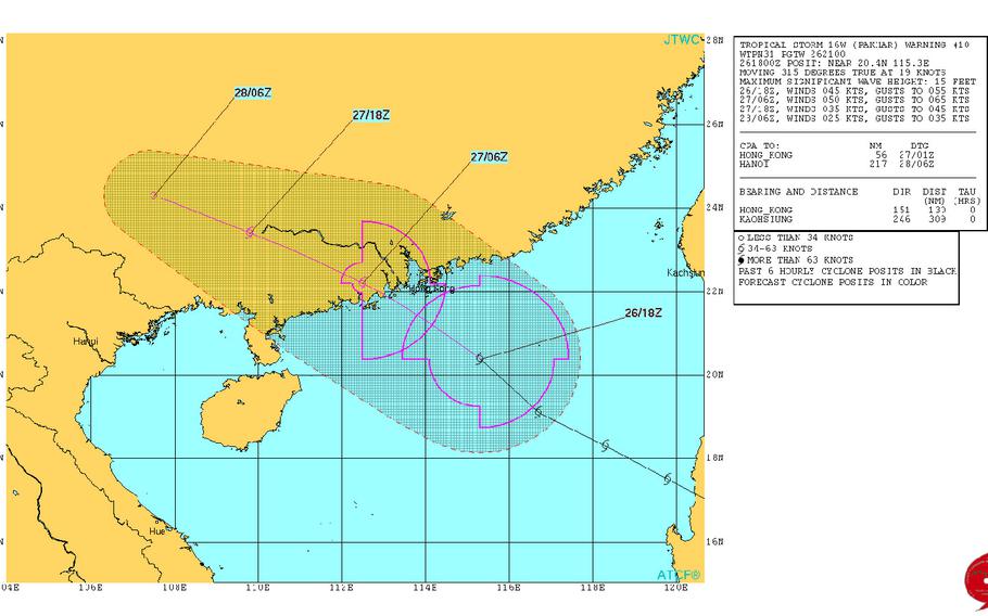
10:30 p.m. Saturday, Aug. 26, Hong Kong time: Hong Kong Observatory has raised Strong Wind Signal 3 for Hong Kong at 8:40 p.m., and has not ruled out raising Gale/Storm Signal 8 for the city by dawn Sunday. Still, Tropical Storm Pakhar is not as strong as Hato earlier this week and should pass yet further south of Hong Kong than did Hato.
At 8 p.m., Pakhar was 274 miles southeast of Hong Kong, moving west-northwest at 19 mph and had increased in intensity somewhat, 52-mph sustained winds and 63-mph gusts. Pakhar is forecast to peak at 63-mph sustained winds and 81-mph gusts at mid-morning Sunday and remains on course to pass 125 miles southwest of Hong Kong at 10 a.m. Sunday.
5 p.m. Saturday, Aug. 26, Hong Kong time: All tropical cyclone warning signals for the Philippines have been dropped by the country’s weather authority PAGASA , while Standby Signal 1 has been issued for Hong Kong in advance of Tropical Storm Pakhar’s approach by the Hong Kong Observatory.
At 2 p.m., Pakhar was 312 miles northwest of Manila, moving west-northwest at 18 mph with 46-mph sustained winds and 58-mph gusts at center. If it remains on its current track, Pakhar is forecast to pass 122 miles southwest of Hong Kong at 9 a.m. Sunday.
HKO reports it may issue Strong Wind Signal 3 by midnight Saturday, and though Pakhar is forecast to pass well south, it did not rule out issuing Signal 8, as it did earlier this week when Typhoon Hato battered the city.
10:30 p.m. Friday, Aug. 25, Hong Kong time: Tropical Storm Pakhar has made landfall over the east coast of Luzon in the northern Philippines. Tropical Cyclone Warning Signal 2 remains raised for that part of the country, along with Signal 1 in areas near Manila and the northern islands, according to the country’s weather authority PAGASA.
At 8 p.m., Pakhar was 125 miles east-northeast of Manila, headed west-northwest at 13 mph with 46-mph sustained winds and 58-mph gusts at center. Pakhar, named Jolina in the Philippines, is forecast to pass 125 miles north of Manila and 144 miles north of the former Subic Bay Naval Station about midnight Friday.
Pakhar could threaten Hong Kong next, although the Joint Typhoon Warning Center projects Pakhar to pass 110 miles southwest of Hong Kong at about mid-day Sunday. No wind warning signal has been raised yet for Hong Kong.
———
4:45 p.m. Friday, Aug. 25, Hong Kong time: Tropical Cyclone Warning Signal 2 remains raised for most of central Luzon, with Signal 1 raised for areas as far north as the Babuyan islands to parts of Manila, according to the Philippines’ weather authority PAGASA.
At 2 p.m., Tropical Storm Pakhar began curving northwest, was 159 miles east-northeast of Manila, moving northwest at 10 mph and winds at center had slightly decreased, 40-mph sustained at center and 52 mph gusts. According to the Joint Typhoon Warning Center, Pakhar should peak at 75 mph sustained winds and 92 mph gusts early Sunday afternoon, Category 1-equivalent typhoon strength, before it rams ashore over southeastern China late Sunday afternoon. Pakhar should pass 110 miles north of the former Clark Air Base, 130 miles north of Manila and 148 miles north of the former Subic Bay Naval Station between 9 p.m. Friday and 1 a.m. Saturday as a tropical storm.
11 a.m. Friday, Aug. 25, Hong Kong time: Looks as if Hong Kong might catch a bit of a break, while Manila and the old Clark Air Base and Subic Bay Naval Station might be in for more of a rainy, gusty weekend, according to the Joint Typhoon Warning Center.
At 8 a.m., Tropical Storm Pakhar was 194 miles east of Manila, rumbling west at 15 mph with 46-mph sustained winds and 58-mph gusts at center.
If it remains on its present course, Pakhar is due to pass 51 miles north of Clark, 89 miles north of Subic and 74 miles north of Manila between 10 p.m. Friday and 1 a.m. Saturday. Tropical Cyclone Warning Signal 2 remains raised for central Luzon and Signal 1 in other locales, according to the Philippines’ weather authority PAGASA.
From there, Pakhar is forecast to track northwest toward southeastern China — but probably further south of Hong Kong than when Hato hit earlier this week. JTWC projects Pakhar to pass 140 miles southwest of Hong Kong at 3 p.m. Sunday as a Category 2-equivalent typhoon.
7:30 a.m. Friday, Aug. 25, Philippines time: Tropical Cyclone Warning Signal 2 has been raised for Isabela, northern Aurora, Quirino, Kalinga, Mountain Province, Ifugao and Nueva Vizcaya in central Luzon, according to the Philippines’ national weather authority PAGASA.
Tropical Storm Pakhar is forecast to pass 97 miles north of the old Clark Air Base, 134 miles north of the old Subic Bay Naval Station and 117 miles north of Manila between 8 p.m. and midnight Friday, according to the Joint Typhoon Warning Center.
Pakhar is one of the many international names given to typhoons as assigned by the Japan Meteorological Agency. It’s Laotian for a fresh water fish native to the Mekong River.
5 a.m. Friday, Aug. 25, Hong Kong time: It didn’t take long for Pakhar to be upgraded to a tropical storm overnight Thursday. Its latest Joint Typhoon Warning Center forecast track takes Pakhar over central Luzon and a bit further south of Hong Kong than previously reported.
At 2 a.m., Pakhar was 282 miles east of Manila, headed west at 12 mph with 40-mph sustained winds and 52-mph gusts at center. Tropical Cyclone Warning Signal 1 has been raised for parts of central Luzon in the Philippines by the country’s weather authority PAGASA; Signal 2 could be raised later Friday into Saturday.
Pakhar is forecast to pass 97 miles north of the former Clark Air Base at 1 a.m. Saturday as a severe tropical storm, then 122 miles south-southwest of Hong Kong at 5 p.m. Sunday, peaking as a Category 1-equivalent typhoon, packing 81-mph sustained winds and 98-mph gusts as it makes landfall around 2 a.m. Monday.
12:15 p.m. Thursday, Aug. 24, Philippines time: A tropical cyclone formation alert was issued at 9 a.m. by the Joint Typhoon Warning Center on a disturbance some 650 miles east of Manila. JTWC projects the system to track west or west-northwest and develop gradually as it goes.
Early dynamic model guidance is somewhat split, with the GFS ensemble indicating a zig-zag walk toward southeastern China, southwest of Hong Kong and over Indochina; while the CMC ensemble shows a more northwesterly course between Luzon and Taiwan.
