()
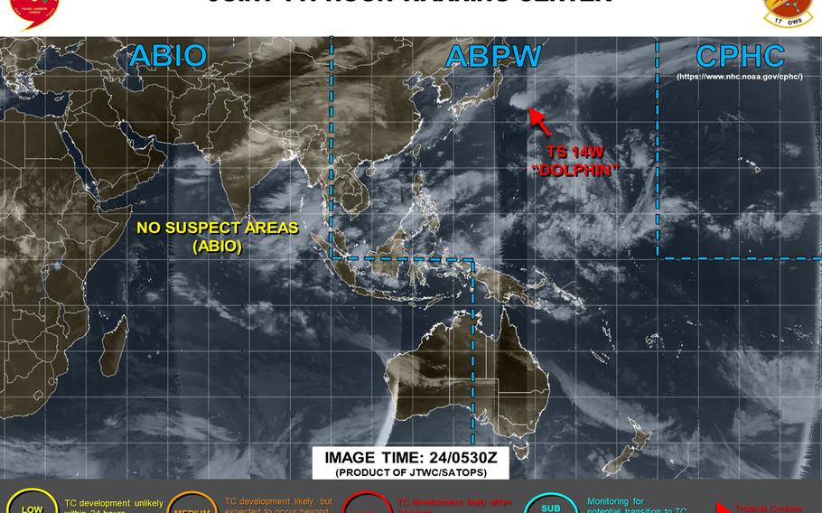
12:30 p.m. Thursday, Sept. 24, Japan time: With Dolphin weakening southeast of Tokyo, Yokosuka Naval Base, Naval Air Facility Atsugi and Camp Zama have reverted to Tropical Cyclone Condition of Readiness All Clear or seasonal TCCOR 5. At 9 a.m., Dolphin was about 200 miles southeast of Yokosuka, still packing 40-mph sustained winds and 52-mph gusts, had ceased forward movement and had converted from a tropical system to a storm-force cold-core low.Joint Typhoon Warning Center reported that Dolphin could remain quasi-stationary and dissipate southeast of Tokyo or gradually crawl north and decay as it moves. Either way, Dolphin appears to be dying out. Unless things change, this is Storm Tracker's final report on Dolphin.Midnight Wednesday, Sept. 23, Japan time: Tropical Storm Dolphin's latest forecast track has lurched much further southeast of the Tokyo area than previously reported. Forecast winds for Yokosuka Naval Base have been dialed back as a result. At 9 p.m., Dolphin was 200 miles south-southeast of Yokosuka, still moving at a brisk pace, east-northeast at 19 mph, and had strengthened slightly, to 63-mph sustained winds and 81-mph gusts at storm's center, according to Joint Typhoon Warning Center. Yokosuka, Camp Zama and Naval Air Facility Atsugi remained in Tropical Cyclone Condition of Readiness Storm Watch at midnight. But forecast closest points of approach to U.S. bases in the Kanto Plain are much further southeast than at last report. If Dolphin stays on present heading, JTWC projects it to pass 191 miles southeast of Yokosuka, 212 miles southeast of Atsugi and Zama and 227 miles southeast of Yokota Air Base between 1 and 2 a.m. Thursday -- much earlier than previously reported.Yokosuka's weather forecast still calls for gale-force winds and heavy rain, peaking northeasterly at 35- to 40-mph sustained and 52-mph gusts as Dolphin passes.Misawa Air Base should also catch something of a break, if the forecast track holds. JTWC projects Dolphin to pass 320 miles east-southeast of Misawa at mid-morning Friday.This report will be updated at mid-day Thursday.6 p.m. Wednesday, Sept. 23, Japan time: Tropical Storm Dolphin continues on a northeast trajectory, with Joint Typhoon Warning Center's forecast track taking it southeast of the Tokyo area at mid-day Thursday. Even Misawa Air Base in northeastern Japan should feel some effect Friday from Dolphin's very outer bands, though destructive winds are not forecast. At 3 p.m., Dolphin was 236 miles south-southwest of Yokosuka Naval Base, moving rather quickly northeast at 18 mph, holding steady at 58-mph sustained winds and 75-mph gusts at center. Yokosuka, Naval Air Facility Atsugi and Camp Zama remain in Tropical Cyclone Condition of Readiness Storm Watch. If Dolphin stays on present heading, JTWC projects it to pass 110 miles southeast of Yokosuka, 131 southeast of Atsugi and Zama and 144 southeast of Yokota Air Base, packing 52-mph sustained winds and 63-mph gusts at storm's center. Yokosuka remains the base closest to Dolphin's forecast track. Yokosuka’s weather forecast continues to call for heavy rain and peak winds of 38- to 44-mph sustained with 63-mph gusts at center at mid-afternoon Thursday, gradually tapering off into Friday. As for Misawa, Dolphin is forecast to pass 229 miles east-southeast at mid-afternoon Friday. Misawa's weather forecast calls for rainshowers and peak northeasterly 35-mph sustained winds and 52-mph gusts Friday afternoon.12:30 p.m. Wednesday, Sept. 23, Japan time: U.S. bases in the Kanto Plain can breathe a slight sigh of relief. They are more out of the line of fire from Tropical Storm Dolphin than previously reported, as Joint Typhoon Warning Center forecasts Dolphin to track further southeast of the Kanto Plain at mid-morning Thursday. At 9 a.m., Dolphin was 294 miles south-southwest of Yokosuka Naval Base, has put the pedal to the metal, moving northeast at 23 mph, and had weakened slightly, to 58-mph sustained winds and 75-mph gusts at center. Yokosuka, Naval Air Facility Atsugi and Camp Zama remain in Tropical Cyclone Condition of Readiness Storm Watch. If Dolphin stays on present heading, JTWC forecasts it to pass 115 miles southeast of Yokosuka, 137 southeast of Zama and Atsugi and 150 miles southeast of Yokota Air Base between 10 and 11 a.m. Thursday, still packing 58-mph sustained winds and 75-mph gusts at storm’s center. Regardless of distance from center, Dolphin remains a tropical system and forecast to be a strong wind and rain event for the Kanto Plain. Yokosuka would be closest to Dolphin if the current track holds, and winds have already begun picking up.Yokosuka’s weather forecast calls for heavy rain and peak winds of 38- to 44-mph sustained with 63-mph gusts at center at mid-afternoon Thursday, gradually tapering off into Friday.Model-track guidance and forecastensembles agree on a track just southeast of the Kanto Plain. More to follow.Midnight Tuesday, Sept. 22, Japan time: Tropical Storm Dolphin has weakened slightly in the last six hours, but remains a significant system. Joint Typhoon Warning Center's latest forecast track depicts a near-direct hit on Yokosuka Naval Base at about noon Thursday. At 9 p.m., Dolphin was 482 miles south-southwest of Yokosuka and had picked up forward speed, moving north-northeast at 13 mph and had weakened to 63-mph sustained winds and 81-mph gusts at center. U.S. bases in the Kanto Plain remained in Tropical Cyclone Condition of Readiness Storm Watch as of midnight. That could stay the same or be upgraded by morning, depending on forecast track and projected sustained winds and gusts. Yokosuka can expect winds to increase as the week progresses. The base's extended weather forecast calls for winds to peak at 40- to 46-mph sustained and 58-mph gusts at 8 a.m. Thursday with plenty of rain, with gradually clearing as the weekend approaches. If Dolphins stays on present heading, JTWC forecasts it to pass almost directly over Yokosuka, 20 miles southeast of Naval Air Facility Atsugi and Camp Zama, 32 miles southeast of Yokota Air Base and 35 miles southeast of Camp Fuji between 10 a.m. and noon Thursday.JTWC continues to forecast Dolphin to become a sub-tropical low, but remain a significant gale-force system as it passes relatively quickly through the Tokyo area. Forecastensembles agree on a track through or southeast of Tokyo.This report will be updated at mid-day Wednesday.6:15 p.m. Tuesday, Sept. 22, Japan time: U.S. bases in the Kanto Plain remain in Tropical Cyclone Condition of Readiness Storm Watch as Tropical Storm Dolphin has reached just below Category 1-equivalent intensity, according to Joint Typhoon Warning Center. And if the current JTWC forecast holds, Dolphin would put Tokyo and Kanto Plain bases in its crosshairs for a possible Thursday afternoon rendevous. Not the sort of winds like Typhoon Faxai last September, but still a significant system. At 3 p.m. Tuesday, Dolphin was 567 miles south-southwest of Yokosuka Naval Base, moving roughly due north at 9 mph, packing 69-mph sustained winds and 86-mph gusts at center. If Dolphin stays on its present course, JTWC projects it to make landfall at about 3 p.m. Thursday, passing between Yokosuka to its northwest and southeast of Naval Air Facility Atsugi, Camp Zama and Yokota Air Base, packing 58-mph sustained winds and 75-mph gusts at center. Dolphin is forecast to convert into a sub-tropical low in the next day or so, but JTWC and Yokosuka's weather forecast call for it to remain a storm-force system, a significant wind and rain event later in the week for the Kanto Plain. Yokosuka can expect winds increasing tonight, peaking at 40- to 46-mph sustained winds and 58-mph gusts at 8 a.m. Thursday, gradually diminishing into Friday. Stronger winds might trigger upgraded TCCORs for Kanto Plain bases, if needed.Forecastensembles have come into much better agreement on a track toward the Tokyo area, but still with some outliers. More to follow around midnight, and again at mid-day Wednesday.12:50 p.m. Tuesday, Sept. 22, Japan time: U.S. bases in the Kanto Plain have entered Tropical Cyclone Condition of Readiness Storm Watch in advance of Tropical Storm Dolphin's forecast arrival Thursday evening. Destructive winds are not forecast for the Tokyo area at the moment, and Dolphin is forecast to transition to a sub-tropical low within the next 24 hours, before it reaches the Tokyo area. But Joint Typhoon Warning Center projects Dolphin to remain a strong system nonetheless. Gale-force winds are forecast as Dolphin moves through the area Thursday evening into Friday.Yokosuka Naval Base's extended forecast calls for winds picking up late Tuesday evening, peaking at 38- to 44-mph sustained with 58-mph gusts late Thursday evening into Friday, subsiding from there. Heavy rain is on tap as well. At 9 a.m., Dolphin was 634 miles south-southwest of Yokosuka, moving due north at 9 mph packing 58-mph sustained winds and 75-mph gusts at center. JTWC forecasts Dolphin to peak at mid-morning Wednesday at 63-mph sustained and 81-mph gusts at center. Sub-tropical transition is forecast to begin later today and complete in the next day or so. If Dolphin stays on present heading, JTWC projects it to make landfall between Shizuoka and the Izu Peninsula southwest of Tokyo sometime Thursday evening, knifing between Naval Air Facility Atsugi, Camp Zama and Yokota Air Base around 7 p.m. Thursday. The ECMWF, UKMET and GFS forecast ensembles have come into better agreement, but there remains a 120-mile spread among solutions two days out, JTWC reports. More to follow this evening.12:15 a.m. Tuesday, Sept. 22, Japan time: Yokosuka Naval Base might get a wet, gusty visitor later this week if the Joint Typhoon Warning Center's forecast for Tropical Storm Dolphin holds, even as a sub-tropical low; it's projected to still be a significant system. At 9 p.m., Dolphin was 720 miles south-southwest of Yokosuka and 455 miles east of Kadena Air Base, Okinawa, crawling north-northeast at 5 mph, holding steady at 52-mph sustained winds and 63-mph gusts. Though Dolphin features some sub-tropical characteristics, it remains a tropical system for now. But as it moves north-northeast in the coming days, JTWC forecasts it to encounter increasing wind shear and decreasing sea-surfact temperatures. Still, JTWC projects Dolphin to be packing 52-mph sustained winds and 63-mph gusts as it gets within reach of land. The current forecast track shows Dolphin headed toward landfall between Shizuoka and the Izu Peninsula southwest of Tokyo late Thursday.Yokosuka's extended weather forecast calls for gale-force winds Wednesday into Thursday, peaknig at 40- to 46-mph sustained and 58-mph gusts at mid-morning Thursday, subsiding as Friday approaches. But JTWC also reports a spread of 313 miles among model solutions three days out. The ECMWF and UKMET forecast ensembles indicate a track toward central Honshu, while the GFS ensemble favors a track just southeast of Yokosuka. In short, the one thing certain is uncertainty. Much can change yet. Dolphin is just over a day old. Stay tuned. This will be updated at mid-day to mid-afternoon Tuesday.6:30 p.m. Monday, Sept. 21, Japan time: Tropical Storm Dolphin is forecast to peak at just-below typhoon intensity and head in the general direction of central Honshu in Japan later this week, according to Joint Typhoon Warning Center. At 3 p.m., Dolphin was 750 miles south-southwest of Yokosuka Naval Base and 437 miles east of Kadena Air Base, Okinawa, and was holding at 52-mph sustained winds and 63-mph gusts at center. All U.S. bases remain in seasonal tropical cyclone conditions of readiness, 4, 5 or all clear depending on which base. JTWC continues to report Dolphin having some sub-tropical characteristics, but for now remains a tropical system. JTWC projects Dolphin to peak at 69-mph sustained winds and 86-mph gusts, just shy of Category 1-equivalent intensity, by mid-afternoon Wednesday, and curve northeast toward central Honshu. Its final long-term destination remains up in the air. Okinawa, Sasebo Naval Base and Marine Corps Air Station Iwakuni appear to be out of harm's way. JTWC forecasts Dolphin to pass 432 miles east of Kadena at 8 a.m. Tuesday, 382 southeast of Sasebo at 5 p.m. Wednesday and 275 southeast of Iwakuni at 3 a.m. Thursday.JTWC reports a vast spread among model solutions long-term. Model-track guidance shows tracks southeast of Tokyo, as does the GFS forecast ensemble; the ECMWF ensemble has fallen more in line with the others, but still shows a track slightly further west.2:15 p.m. Monday, Sept. 21, Japan time: Tropical Storm Dolphin has intensified some in the last several hours, and is forecast to transition into a sub-tropical low 1 1/2 days out, according to the Joint Typhoon Warning Center. Where it heads long-term, and how strong that low might remain, continues to be up in the air, as model guidance and solutions continue to differ. At 9 a.m., Dolphin was 400 miles east-southeast of Kadena Air Base, Okinawa and had picked up some forward speed, north at 7 mph, packing 52-mph sustained winds and 63-mph gusts at center. Okinawa continues to remain well out of harm's way; JTWC forecasts Dolphin to pass 420 miles east of Kadena at about 11 a.m. Tuesday, 10 hours before reaching its forecast peak of 63-mph sustained winds and 81-mph gusts, well away from any land mass. All U.S. bases in Japan and Okinawa remain in seasonal Tropical Cyclone Conditions of Readiness, either 4, 5 or All Clear depending on which base.Model-track guidance and forecast ensembles continue to stray all over the lot, with GFS depicting a track toward the Tokyo area and ECMWF more toward central Japan's Osaka Kansai region. Still early in Dolphin's life. Stay tuned.7:15 a.m. Monday, Sept. 21, Japan time: Tropical Storm 14W continues crawling north at 2 mph and is holding steady at 40-mph sustained winds and 52-mph gusts. At 3 a.m., 14W was 415 miles east-southeast of Kadena Air Base, Okinawa. Joint Typhoon Warning Center forecasts 14W to keep moving generally north, transitioning into a sub-tropical low in the next 1 1/2 days, peaking at 58-mph sustained winds at mid-afternoon Tuesday. Long-term, much remains uncertain. Model-track guidance and forecastensembles show a spread among solutions. GFS depicts a track northeast, passing southeast of the Tokyo area in the next three to four days, while ECMWF favors a track toward Japan's Kansai region. Stay tuned.12:45 a.m. Monday, Sept. 21, Japan time: And just like that, the 14th numbered tropical cyclone of the northwest Pacific's season has spun up well off the southern coast of Japan and east of Okinawa. At 9 p.m., Tropical Storm 14W was 421 miles east-southeast of Kadena Air Base, 702 miles south of Marine Corps Air Station Iwakuni and 863 miles south-southwest of Yokosuka Naval Base, crawling north at 4 mph with 40-mph sustained winds and 52-mph gusts at center. Joint Typhoon Warning Center forecasts 14W to continue doing a slow crawl north over the next two days, peaking at 63-mph sustained winds and 81-mph gusts at center. But much remains uncertain about its forecast track and timing; more on that later. For the moment, Okinawa, Sasebo Naval Base and Iwakuni appear to have little worry from 14W, according to JTWC's forecast closest points of approach. If 14W remains on its initial course, JTWC projects it to pass 333 miles east of Kadena at 6 p.m. Tuesday, 354 miles southeast of Sasebo at 3 a.m. Thursday and 261 miles south-southeast of Iwakuni at 11 a.m. Thursday. All those locations remain either in seasonal Tropical Cyclone Condition of Readiness 4, 5 or All Clear. 14W is forecast to curve northeast on Thursday, picking up forward speed and hurtling toward central Honshu, between Shizuoka and Hamamatsu near Mount Fuji, weakening to 46-mph sustained winds as it goes on course for landfall late Thursday. But much can change during that span. JTWC reports a spread of 633 miles among solutions three days out and 725 four days out. Model-track guidance and forecastensembles shows similar. Stay tuned.6 p.m. Sunday, Sept. 20, Japan time: Disturbance 93W Invest continues lurking well south of Japan and east of Okinawa. Model guidance depicts a northeast turn in the coming days, with Joint Typhoon Warning Center indicating passage southeast of Tokyo possibly as a sub-tropical low. At 3 p.m., 93W was 422 miles east-southeast of Kadena Air Base and 861 miles south-southwest of Yokosuka Naval Base. U.S. bases on Okinawa remain in seasonal Tropical Cyclone Condition of Readiness 4, and Fleet Activities Yokosuka in TCCOR All Clear.Model-track guidance and forecastensembles indicate Okinawa out of harm's way and 93W passing southeast of Tokyo in the coming days, with a vast spread among solutions and timing.Yokosuka's extended forecast continues to call for showers with winds picking up Tuesday afternoon, peaking at 30-mph gusts into the evening and into Wednesday morning.1 a.m. Sunday, Sept. 20, Japan time: Disturbance 93W continues developing south of Japan. At midnight Saturday, 93W was 995 miles south-southwest of Yokosuka Naval Base and 581 miles east-southeast of Kadena Air Base, Okinawa, according to Joint Typhoon Warning Center.Model-track guidance and the GFS forecast ensembles indicate it could turn northeast and pass southeast of Yokosuka and the Tokyo/Kanto Plain area as a tropical storm two to three days out and be through the area rather quickly. Yokosuka's extended weather forecast calls for winds increasing Tuesday afternoon and evening, with gusts as high as 30 mph, and showers into Wednesday morning.7 p.m. Saturday, Sept. 19, Japan time: A tropical disturbance labeled 93W Invest has begun forming south of Japan. At 6:45 p.m., 93W was 1,012 miles south-southwest of Yokosuka Naval Base.
Model-track guidance and the Global Forecast System forecast ensemble depicts 93W moving north-northeast, passing southeast of Tokyo/Kanto Plain, possibly as a tropical depression or weak tropical storm, by the middle of next week.
4 p.m. Saturday, Sept. 12, Japan time: Well, that didn't last long. Already, Joint Typhoon Warning Center has issued its final warning on Tropical Depression 12W. And wind forecast for Yokosuka Naval Base this weekend has been dialed back quite a bit. At 9 a.m., 12W was 272 miles south-southwest of Yokosuka, moving north-northeast at 7 mph, still with 29-mph sustained winds and 40-mph gusts at center. JTWC forecasts 12W to maintain that intensity as it curves northeast, passing 84 miles southeast of Yokosuka at about 2 a.m. Sunday.The weather outlook for Yokosuka still includes showers and isolated thunderstorms through the weekend into Monday morning, but with northeasterly winds Saturday between 12 and 18 mph sustained, becoming light and variable Sunday morning. Unless something changes drastically, this is Storm Tracker's final report on 12W.7 a.m. Saturday, Sept. 12, Japan time: Tropical Depression 12W spawned overnight Friday, and according to the Joint Typhoon Warning Center is forecast to curve just offshore of the Tokyo-Kanto Plain area late Saturday into Sunday. At 3 a.m., 12W was 316 miles south-southwest of Yokosuka Naval Base, moving north-northwest at 16 mph with 29-mph sustained winds and 40-mph gusts at center. If it remains on its present heading, JTWC forecasts 12W to curve northeast, peaking at 35-mph sustained winds and 46-mph gusts and passing 39 miles southeast of Yokosuka at about 11 p.m. Saturday.Yokosuka's weather forecast calls for showers and thunderstorms through the weekend, with winds peaking north-northeasterly at 23- to 28-mph sustained with 35-mph gusts Saturday afternoon and evening.1:20 a.m. Saturday, Sept. 12, Japan time: Give disturbance 97W Invest credit for persistence.A tropical cyclone formation alert remains in effect on 97W. Joint Typhoon Warning Center continues to carry it as a "high" area, meaning chances of it developing into a tropical cyclone in the next 24 hours remain high. At 9 p.m., 97W was 328 miles north-northwest of Iwo Jima and 417 miles south of Yokosuka Naval Base, moving north-northwest at 9 mph. JTWC forecasts 97W to keep moving generally north-northwest in the next 24 hours.Model-track guidance depicts 97W moving north, then hang a right turn just before reaching land southeast of Yokosuka and heading east into open sea.Yokosuka's weather forecast calls for showers and thunderstorms during the weekend with winds peaking north-northeast at 18- to 23-mph sustained and 35-mph gusts late Saturday and early Sunday morning.1 a.m. Friday, Sept. 11, Japan time: A tropical cyclone formation alert has been issued on a disturbance, labeled 97W Invest, by the Joint Typhoon Warning Center. At midnight Thursday, 97W was 47 miles north-northwest of Iwo Jima and 690 miles south of Yokosuka Naval Base, JTWC reported.Model track guidance and forecastensembles indicate a northwest track followed by a sharp curve east out to sea, during the upcoming weekend, before reaching land southeast of the Tokyo-Kanto Plain area.
